The LS15 postcode district is a postal district located in the LS Leeds postcode area with a population of 35,941 residents according to the 2021 England and Wales Census.
The area of the LS15 postcode district is 13.59 square miles which is 35.21 square kilometres or 8,699.63 acres.
Currently, the LS15 district has about 973 postcode units spread across 6 geographic postcode sectors.
Given that each sector allows for 400 unique postcode combinations, the district has a capacity of 2,400 postcodes. With 973 postcodes already in use, this leaves 1427 units available.
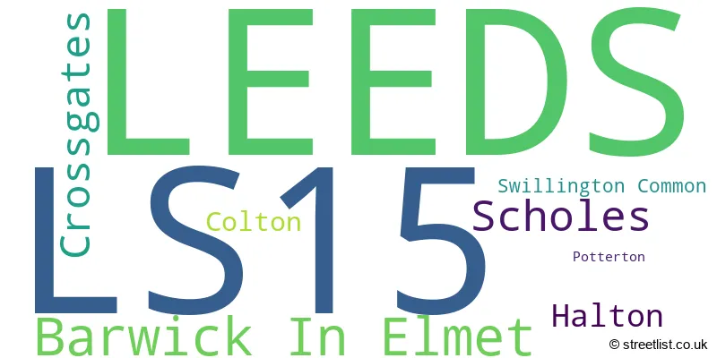
The largest settlement in the LS15 postal code is LEEDS followed by Barwick In Elmet, and Scholes.
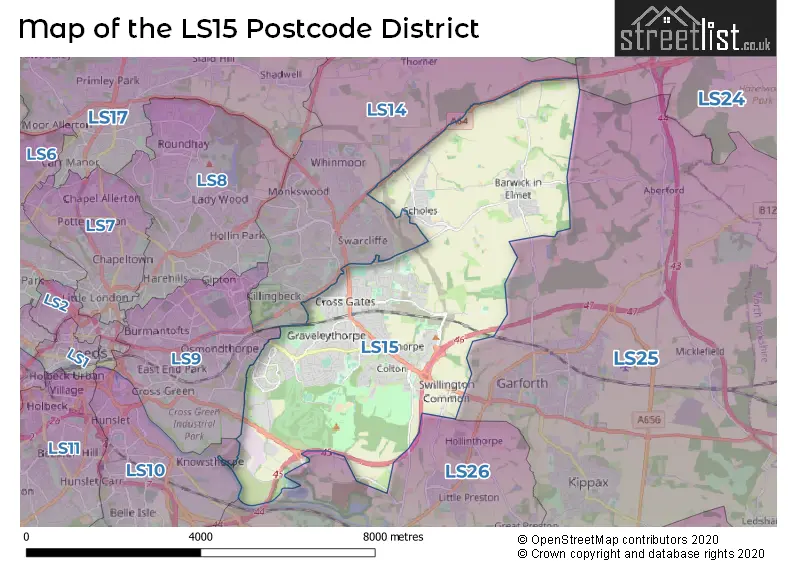
The LS15 Postcode shares a border with LS10 (LEEDS, Hunslet, Middleton), LS25 (Garforth, Sherburn In Elmet, Kippax), LS26 (Rothwell, Woodlesford, Methley), LS9 (LEEDS, Cross Green) and LS14 (LEEDS, Seacroft, Thorner).
The primary settlement in the LS15 postcode district is Leeds, located in West Yorkshire. Other significant settlements include Barwick In Elmet, Potterton, Scholes, Swillington Common, Crossgates, and Colton. The most significant Postal Town in the district is Leeds.
For the district LS15, we have data on 6 postcode sectors. Here's a breakdown: The sector LS15 0, covers Leeds in West Yorkshire. The sector LS15 4, covers Barwick In Elmet and Scholes in West Yorkshire. The sector LS15 5, covers Leeds in West Yorkshire. The sector LS15 7, covers Leeds and Halton in West Yorkshire. The sector LS15 8, covers Leeds and Crossgates in West Yorkshire. The sector LS15 9, covers Leeds and Colton in West Yorkshire.

Map of the LS15 Postcode District
Explore the LS15 postcode district by using our free interactive map.
When it comes to local government, postal geography often disregards political borders. However, for a breakdown in the LS15 District: the district mostly encompasses the Leeds District (B) area with a total of 987 postcodes.
Recent House Sales in LS15
| Date | Price | Address |
|---|---|---|
| 25/10/2023 | £193,000 | Cusworth Garth, Leeds, LS15 8GN |
| 20/10/2023 | £163,000 | Oak Crescent, Leeds, LS15 0DS |
| 29/09/2023 | £202,000 | Bennet Court, Leeds, LS15 9AX |
| 21/09/2023 | £295,000 | Gypsy Wood Close, Leeds, LS15 9DY |
| 14/09/2023 | £265,000 | Pendas Walk, Leeds, LS15 8HS |
| 11/09/2023 | £260,000 | Templenewsam Road, Leeds, LS15 0DX |
| 08/09/2023 | £237,500 | Orchard Road, Leeds, LS15 7LP |
| 01/09/2023 | £225,550 | Birch Avenue, Leeds, LS15 7QY |
| 30/08/2023 | £227,000 | Highland Court, Leeds, LS15 0FA |
| 29/08/2023 | £338,000 | Arthursdale Grange, Scholes, Leeds, LS15 4AW |
Weather Forecast for LS15
Press Button to Show Forecast for Stanks
| Time Period | Icon | Description | Temperature | Rain Probability | Wind |
|---|---|---|---|---|---|
| 00:00 to 03:00 | Partly cloudy (night) | 4.0°C (feels like 1.0°C) | 1.00% | NNW 7 mph | |
| 03:00 to 06:00 | Partly cloudy (night) | 4.0°C (feels like 1.0°C) | 1.00% | NW 7 mph | |
| 06:00 to 09:00 | Cloudy | 4.0°C (feels like 1.0°C) | 4.00% | NW 7 mph | |
| 09:00 to 12:00 | Cloudy | 7.0°C (feels like 4.0°C) | 5.00% | N 11 mph | |
| 12:00 to 15:00 | Cloudy | 9.0°C (feels like 7.0°C) | 8.00% | N 9 mph | |
| 15:00 to 18:00 | Overcast | 10.0°C (feels like 8.0°C) | 7.00% | N 9 mph | |
| 18:00 to 21:00 | Cloudy | 9.0°C (feels like 7.0°C) | 5.00% | NNE 7 mph | |
| 21:00 to 00:00 | Cloudy | 7.0°C (feels like 5.0°C) | 9.00% | NE 4 mph |
Press Button to Show Forecast for Stanks
| Time Period | Icon | Description | Temperature | Rain Probability | Wind |
|---|---|---|---|---|---|
| 00:00 to 03:00 | Overcast | 6.0°C (feels like 5.0°C) | 9.00% | NNE 2 mph | |
| 03:00 to 06:00 | Overcast | 5.0°C (feels like 4.0°C) | 17.00% | N 4 mph | |
| 06:00 to 09:00 | Light rain | 5.0°C (feels like 4.0°C) | 45.00% | NNE 4 mph | |
| 09:00 to 12:00 | Light rain | 6.0°C (feels like 5.0°C) | 42.00% | NE 4 mph | |
| 12:00 to 15:00 | Overcast | 8.0°C (feels like 7.0°C) | 15.00% | NE 7 mph | |
| 15:00 to 18:00 | Light rain | 9.0°C (feels like 8.0°C) | 46.00% | NE 7 mph | |
| 18:00 to 21:00 | Overcast | 8.0°C (feels like 6.0°C) | 13.00% | NE 7 mph | |
| 21:00 to 00:00 | Cloudy | 6.0°C (feels like 4.0°C) | 10.00% | ENE 4 mph |
Press Button to Show Forecast for Stanks
| Time Period | Icon | Description | Temperature | Rain Probability | Wind |
|---|---|---|---|---|---|
| 00:00 to 03:00 | Cloudy | 5.0°C (feels like 3.0°C) | 9.00% | NNE 2 mph | |
| 03:00 to 06:00 | Overcast | 4.0°C (feels like 3.0°C) | 21.00% | N 2 mph | |
| 06:00 to 09:00 | Cloudy | 5.0°C (feels like 4.0°C) | 22.00% | ENE 4 mph | |
| 09:00 to 12:00 | Light rain | 7.0°C (feels like 5.0°C) | 53.00% | S 4 mph | |
| 12:00 to 15:00 | Light rain | 8.0°C (feels like 7.0°C) | 55.00% | SE 7 mph | |
| 15:00 to 18:00 | Light rain | 9.0°C (feels like 8.0°C) | 49.00% | E 7 mph | |
| 18:00 to 21:00 | Light rain | 9.0°C (feels like 8.0°C) | 47.00% | NE 7 mph | |
| 21:00 to 00:00 | Overcast | 7.0°C (feels like 6.0°C) | 10.00% | NE 4 mph |
Press Button to Show Forecast for Stanks
| Time Period | Icon | Description | Temperature | Rain Probability | Wind |
|---|---|---|---|---|---|
| 00:00 to 03:00 | Cloudy | 7.0°C (feels like 5.0°C) | 7.00% | ENE 4 mph | |
| 03:00 to 06:00 | Cloudy | 6.0°C (feels like 4.0°C) | 6.00% | N 7 mph | |
| 06:00 to 09:00 | Cloudy | 7.0°C (feels like 4.0°C) | 8.00% | NNE 9 mph | |
| 09:00 to 12:00 | Overcast | 8.0°C (feels like 6.0°C) | 11.00% | NNE 9 mph | |
| 12:00 to 15:00 | Overcast | 10.0°C (feels like 8.0°C) | 19.00% | NNE 11 mph | |
| 15:00 to 18:00 | Overcast | 10.0°C (feels like 8.0°C) | 16.00% | NNE 11 mph | |
| 18:00 to 21:00 | Sunny day | 9.0°C (feels like 7.0°C) | 7.00% | NNE 9 mph | |
| 21:00 to 00:00 | Clear night | 6.0°C (feels like 4.0°C) | 9.00% | NNE 7 mph |
Where is the LS15 Postcode District?
The postcode district LS15 is located in the town of Leeds. It is situated near several towns in different directions. To the South East, there is Castleford, which is approximately 6.6 miles away. Normanton is located to the South, around 7.3 miles away. Tadcaster is situated to the North East, around 7.9 miles away. Wetherby is located to the North, approximately 8.7 miles away. Pudsey is situated to the West, around 9.8 miles away. Ossett is located to the South West, approximately 10.5 miles away. Additionally, the distance from LS15 to London is approximately 168.2 miles.
The district is within the post town of LEEDS.
The sector has postcodes within the nation of England.
The LS15 Postcode District is in the Leeds region of West Yorkshire within the Yorkshire and The Humber.
| Postcode Sector | Delivery Office |
|---|---|
| LS15 0 | Seacroft Delivery Office |
| LS15 4 | Seacroft Delivery Office |
| LS15 5 | Seacroft Delivery Office |
| LS15 7 | Seacroft Delivery Office |
| LS15 8 | Seacroft Delivery Office |
| LS15 9 | Seacroft Delivery Office |
| L | S | 1 | 5 | - | X | X | X |
| L | S | 1 | 5 | Space | Numeric | Letter | Letter |
Tourist Attractions within the Postcode Area
We found 1 visitor attractions within the LS15 postcode area
| Temple Newsam House and Farm |
|---|
| Museums & Art Galleries |
| Museum and / or Art Gallery |
| View Temple Newsam House and Farm on Google Maps |
Current Monthly Rental Prices
| # Bedrooms | Min Price | Max Price | Avg Price |
|---|---|---|---|
| £575 | £575 | £575 | |
| 1 | £650 | £695 | £680 |
| 2 | £850 | £980 | £933 |
| 3 | £875 | £1,300 | £1,121 |
| 4 | £1,300 | £2,000 | £1,600 |
Current House Prices
| # Bedrooms | Min Price | Max Price | Avg Price |
|---|---|---|---|
| £59,950 | £240,000 | £149,975 | |
| 1 | £65,000 | £109,000 | £77,750 |
| 2 | £110,000 | £389,000 | £228,577 |
| 3 | £140,000 | £460,000 | £288,596 |
| 4 | £280,000 | £1,300,000 | £471,897 |
| 5 | £374,950 | £875,000 | £585,849 |
| 6 | £450,000 | £550,000 | £500,000 |
Estate Agents who Operate in the LS15 District
| Logo | Name | Brand Name | Address | Contact Number | Total Properties |
|---|---|---|---|---|---|
 | Crossgates | Manning Stainton | 62 Austhorpe Road, Leeds, LS15 8DX | 0113 519 1494 | 67 |
 | Whitkirk | Stoneacre Properties | 1 Colton Road, Whitkirk, Leeds, LS15 9AA | 0113 519 1044 | 42 |
 | Crossgates | Emsleys Estate Agents | 35 Austhorpe Road, Leeds, LS15 8BA | 0113 519 4409 | 35 |
 | Crossgates | William H. Brown | 47 Station Road, Crossgates, Leeds, LS15 8DT | 0113 519 0427 | 14 |
 | Crossgates | Reeds Rains | 22 Austhorpe Road, Leeds, LS15 8DX | 0113 519 0554 | 11 |
| Type of Property | 2018 Average | 2018 Sales | 2017 Average | 2017 Sales | 2016 Average | 2016 Sales | 2015 Average | 2015 Sales |
|---|---|---|---|---|---|---|---|---|
| Detached | £293,300 | 101 | £288,567 | 117 | £307,170 | 136 | £267,955 | 162 |
| Semi-Detached | £185,944 | 350 | £183,939 | 335 | £174,876 | 310 | £159,898 | 326 |
| Terraced | £165,438 | 113 | £161,746 | 117 | £148,726 | 121 | £139,357 | 116 |
| Flats | £109,245 | 21 | £86,866 | 19 | £89,324 | 31 | £101,722 | 21 |
Hotels within the Postcode Area
We found 1 hotels and guest houses within the LS15 postcode area
Thorpe Park Hotel and Spa - A Thwaites Hotel and Spa
1150 Century Way, Thorpe Park, Leeds, LS15 8ZB.
View details