The LU1 postcode district is a postal district located in the LU Luton postcode area with a population of 50,512 residents according to the 2021 England and Wales Census.
The area of the LU1 postcode district is 12.65 square miles which is 32.78 square kilometres or 8,099.13 acres.
Currently, the LU1 district has about 932 postcode units spread across 5 geographic postcode sectors.
Given that each sector allows for 400 unique postcode combinations, the district has a capacity of 2,000 postcodes. With 932 postcodes already in use, this leaves 1068 units available.
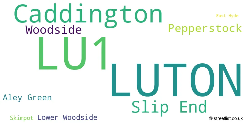
The largest settlement in the LU1 postal code is LUTON followed by Caddington, and Slip End.
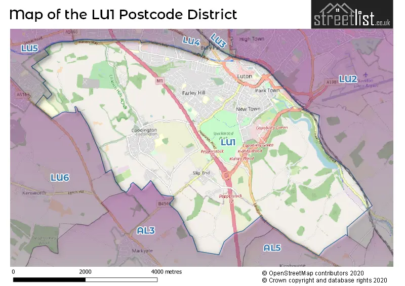
The LU1 Postcode shares a border with AL3 (ST. ALBANS, Redbourn, Markyate), AL5 (HARPENDEN), LU2 (LUTON, Lilley, London Luton Airport), LU3 (LUTON, Sundon), LU4 (LUTON, Chalton, Leagrave), LU5 (Houghton Regis, DUNSTABLE, Toddington) and LU6 (DUNSTABLE, Eaton Bray, Edlesborough).
The primary settlement in the LU1 postcode district is Luton, located in the county of Bedfordshire in England. Other significant settlements include East Hyde, Aley Green, Caddington, Lower Woodside, Pepperstock, Skimpot, Slip End, and Woodside, all of which are also in Bedfordshire. The most significant post town in the LU1 postcode district is Luton.
For the district LU1, we have data on 6 postcode sectors. Here's a breakdown: The sector LU1 1, covers Luton in Bedfordshire. The sector LU1 2, covers Luton in Bedfordshire. The sector LU1 3, covers Luton in Bedfordshire. The sector LU1 4, covers Caddington and Slip End in Bedfordshire. The sector LU1 5, covers Luton in Bedfordshire. The sector LU1 9 is non-geographic. It's often designated for PO Boxes, large organisations, or special services.

Map of the LU1 Postcode District
Explore the LU1 postcode district by using our free interactive map.
When it comes to local government, postal geography often disregards political borders. However, for a breakdown in the LU1 District: the district mostly encompasses the Luton (B) (790 postcodes), followed by the Central Bedfordshire area (143 postcodes), and finally, the Dacorum District (B) area (3 postcodes).
Recent House Sales in LU1
| Date | Price | Address |
|---|---|---|
| 20/10/2023 | £215,000 | King Street, Luton, LU1 2DW |
| 16/10/2023 | £73,761 | Dumfries Street, Luton, LU1 5FT |
| 06/10/2023 | £230,000 | Hibbert Street, Luton, LU1 3UU |
| 11/09/2023 | £460,000 | Tennyson Road, Luton, LU1 3RR |
| 07/09/2023 | £280,304 | Ashburnham Road, Luton, LU1 1JP |
| 07/09/2023 | £485,000 | Front Street, Slip End, Luton, LU1 4BS |
| 07/09/2023 | £425,000 | Markyate Road, Slip End, Luton, LU1 4BU |
| 06/09/2023 | £580,000 | Dove Close, Caddington, Luton, LU1 4FN |
| 01/09/2023 | £290,000 | Vernon Road, Luton, LU1 1NY |
| 01/09/2023 | £220,000 | St Peters Road, Luton, LU1 1PQ |
Weather Forecast for LU1
Press Button to Show Forecast for Luton
| Time Period | Icon | Description | Temperature | Rain Probability | Wind |
|---|---|---|---|---|---|
| 18:00 to 21:00 | Cloudy | 7.0°C (feels like 5.0°C) | 8.00% | NE 7 mph | |
| 21:00 to 00:00 | Cloudy | 5.0°C (feels like 4.0°C) | 4.00% | ENE 4 mph |
Press Button to Show Forecast for Luton
| Time Period | Icon | Description | Temperature | Rain Probability | Wind |
|---|---|---|---|---|---|
| 00:00 to 03:00 | Cloudy | 4.0°C (feels like 2.0°C) | 3.00% | NE 7 mph | |
| 03:00 to 06:00 | Clear night | 2.0°C (feels like 0.0°C) | 1.00% | ENE 4 mph | |
| 06:00 to 09:00 | Partly cloudy (day) | 2.0°C (feels like 0.0°C) | 1.00% | NE 4 mph | |
| 09:00 to 12:00 | Partly cloudy (day) | 7.0°C (feels like 5.0°C) | 2.00% | ENE 7 mph | |
| 12:00 to 15:00 | Cloudy | 10.0°C (feels like 8.0°C) | 7.00% | ENE 4 mph | |
| 15:00 to 18:00 | Overcast | 10.0°C (feels like 9.0°C) | 12.00% | NE 4 mph | |
| 18:00 to 21:00 | Cloudy | 9.0°C (feels like 7.0°C) | 10.00% | ENE 7 mph | |
| 21:00 to 00:00 | Cloudy | 6.0°C (feels like 4.0°C) | 11.00% | ENE 7 mph |
Press Button to Show Forecast for Luton
| Time Period | Icon | Description | Temperature | Rain Probability | Wind |
|---|---|---|---|---|---|
| 00:00 to 03:00 | Cloudy | 4.0°C (feels like 1.0°C) | 12.00% | ENE 7 mph | |
| 03:00 to 06:00 | Cloudy | 3.0°C (feels like 0.0°C) | 14.00% | ENE 7 mph | |
| 06:00 to 09:00 | Cloudy | 4.0°C (feels like 1.0°C) | 22.00% | NE 7 mph | |
| 09:00 to 12:00 | Cloudy | 8.0°C (feels like 5.0°C) | 18.00% | ENE 9 mph | |
| 12:00 to 15:00 | Overcast | 11.0°C (feels like 9.0°C) | 19.00% | ENE 9 mph | |
| 15:00 to 18:00 | Overcast | 11.0°C (feels like 9.0°C) | 20.00% | E 11 mph | |
| 18:00 to 21:00 | Cloudy | 10.0°C (feels like 8.0°C) | 18.00% | ENE 9 mph | |
| 21:00 to 00:00 | Light rain | 8.0°C (feels like 5.0°C) | 54.00% | NE 11 mph |
Press Button to Show Forecast for Luton
| Time Period | Icon | Description | Temperature | Rain Probability | Wind |
|---|---|---|---|---|---|
| 00:00 to 03:00 | Heavy rain | 7.0°C (feels like 4.0°C) | 72.00% | NE 11 mph | |
| 03:00 to 06:00 | Heavy rain | 8.0°C (feels like 5.0°C) | 77.00% | NE 9 mph | |
| 06:00 to 09:00 | Light rain | 8.0°C (feels like 6.0°C) | 53.00% | SE 9 mph | |
| 09:00 to 12:00 | Light rain | 10.0°C (feels like 8.0°C) | 53.00% | ESE 9 mph | |
| 12:00 to 15:00 | Heavy rain shower (day) | 11.0°C (feels like 9.0°C) | 61.00% | SE 9 mph | |
| 15:00 to 18:00 | Light rain shower (day) | 12.0°C (feels like 10.0°C) | 41.00% | SSW 11 mph | |
| 18:00 to 21:00 | Light rain shower (day) | 10.0°C (feels like 8.0°C) | 36.00% | W 11 mph | |
| 21:00 to 00:00 | Cloudy | 8.0°C (feels like 6.0°C) | 10.00% | WSW 7 mph |
Where is the LU1 Postcode District?
The postcode district LU1 is located in the town of Luton. Luton is surrounded by several nearby towns such as Dunstable to the West, Harpenden to the South East, Hemel Hempstead to the South, Hitchin to the North East, and Berkhamsted to the South West. The distance from Luton to the center of London is approximately 27.8 miles.
The district is within the post town of LUTON.
The sector has postcodes within the nation of England.
The LU1 Postcode District is covers the following regions.
- Luton - Bedfordshire and Hertfordshire - East of England
- Central Bedfordshire - Bedfordshire and Hertfordshire - East of England
- Hertfordshire - Bedfordshire and Hertfordshire - East of England
| Postcode Sector | Delivery Office |
|---|---|
| LU1 1 | Luton Delivery Office |
| LU1 2 | Luton Delivery Office |
| LU1 3 | Luton Delivery Office |
| LU1 4 | Luton Delivery Office |
| LU1 5 | Luton Delivery Office |
| L | U | 1 | - | X | X | X |
| L | U | 1 | Space | Numeric | Letter | Letter |
Current Monthly Rental Prices
| # Bedrooms | Min Price | Max Price | Avg Price |
|---|---|---|---|
| £50 | £1,733 | £716 | |
| 1 | £400 | £1,325 | £819 |
| 2 | £950 | £1,525 | £1,255 |
| 3 | £1,450 | £3,150 | £1,817 |
| 4 | £1,950 | £1,950 | £1,950 |
| 5 | £2,300 | £3,000 | £2,650 |
Current House Prices
| # Bedrooms | Min Price | Max Price | Avg Price |
|---|---|---|---|
| £30,000 | £2,400,000 | £156,791 | |
| 1 | £50,000 | £260,000 | £159,275 |
| 2 | £100,000 | £475,000 | £230,649 |
| 3 | £200,000 | £699,950 | £341,103 |
| 4 | £230,000 | £875,000 | £509,730 |
| 5 | £350,000 | £3,850,000 | £1,032,222 |
| 6 | £325,000 | £2,500,000 | £795,833 |
| 7 | £525,000 | £525,000 | £525,000 |
Estate Agents who Operate in the LU1 District
| Logo | Name | Brand Name | Address | Contact Number | Total Properties |
|---|---|---|---|---|---|
 | Luton | Taylors Estate Agents | 27 George Street, Luton LU1 2AF | 01582 377982 | 39 |
 | London | RW Invest | City Point 1 Ropemaker St London EC2Y 9AW | 020 3907 9852 | 38 |
 | Luton | Esquire Estates | 208 Marsh Road, Leagrave, Luton, LU3 2QW | 01582 377323 | 33 |
 | Luton | Connells | 83 George Street Luton Bedfordshire LU1 2AT | 01582 377356 | 33 |
 | Liverpool | Urban Evolution | Third Floor Honeycomb & Helix Building , Edmund Street, Liverpool L3 9NG | 0151 453 3028 | 30 |
| Type of Property | 2018 Average | 2018 Sales | 2017 Average | 2017 Sales | 2016 Average | 2016 Sales | 2015 Average | 2015 Sales |
|---|---|---|---|---|---|---|---|---|
| Detached | £491,713 | 61 | £505,852 | 100 | £464,153 | 36 | £423,276 | 59 |
| Semi-Detached | £304,678 | 130 | £302,266 | 156 | £276,455 | 168 | £229,645 | 131 |
| Terraced | £220,496 | 217 | £232,472 | 232 | £219,605 | 249 | £181,615 | 258 |
| Flats | £138,282 | 396 | £115,682 | 420 | £116,971 | 185 | £104,484 | 203 |