The M13 postcode district is a postal district located in the M Manchester postcode area with a population of 24,285 residents according to the 2021 England and Wales Census.
The area of the M13 postcode district is 1.13 square miles which is 2.92 square kilometres or 722.11 acres.
Currently, the M13 district has about 484 postcode units spread across 2 geographic postcode sectors.
Given that each sector allows for 400 unique postcode combinations, the district has a capacity of 800 postcodes. With 484 postcodes already in use, this leaves 316 units available.
The M13 postal code covers the settlement of MANCHESTER.
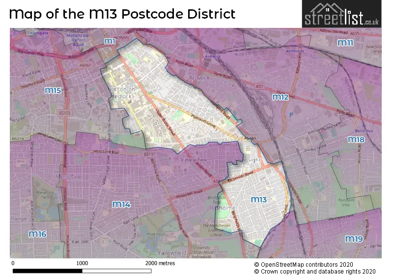
The M13 Postcode shares a border with M19 (MANCHESTER, Levenshulme), M15 (MANCHESTER, Hulme, Manchester Science Park), M12 (MANCHESTER, Longsight, Ardwick) and M14 (MANCHESTER, Fallowfield).
The primary settlement in the M13 postcode district is Manchester, located in the county of Greater Manchester in England. The most significant post town is also Manchester. Additionally, there is another settlement called Longsight within the M13 postcode district.
For the district M13, we have data on 2 postcode sectors. Here's a breakdown: The sector M13 0, covers Manchester in Greater Manchester. The sector M13 9, covers Manchester in Greater Manchester.


Map of the M13 Postcode District
Explore the M13 postcode district by using our free interactive map.
When it comes to local government, postal geography often disregards political borders. However, for a breakdown in the M13 District: the district mostly encompasses the Manchester District (B) area with a total of 489 postcodes.
Recent House Sales in M13
| Date | Price | Address |
|---|---|---|
| 18/10/2023 | £275,000 | Aspull Walk, Manchester, M13 9ER |
| 06/10/2023 | £305,500 | Hathersage Road, Manchester, M13 0EJ |
| 31/08/2023 | £216,000 | Whiley Street, Manchester, M13 0WR |
| 31/08/2023 | £120,000 | Birch Lane, Manchester, M13 0NW |
| 21/08/2023 | £165,000 | Plymouth Grove, Manchester, M13 9HX |
| 21/08/2023 | £93,000 | Hyde Grove, Manchester, M13 9LQ |
| 18/08/2023 | £355,000 | Upper Brook Street, Manchester, M13 9JS |
| 31/07/2023 | £93,000 | Hyde Grove, Manchester, M13 9LQ |
| 25/07/2023 | £310,000 | Montgomery Road, Manchester, M13 0PW |
| 18/07/2023 | £143,000 | Aspull Walk, Manchester, M13 9ER |
Weather Forecast for M13
Press Button to Show Forecast for Rusholme
| Time Period | Icon | Description | Temperature | Rain Probability | Wind |
|---|---|---|---|---|---|
| 21:00 to 00:00 | Overcast | 9.0°C (feels like 7.0°C) | 7.00% | NNE 4 mph |
Press Button to Show Forecast for Rusholme
| Time Period | Icon | Description | Temperature | Rain Probability | Wind |
|---|---|---|---|---|---|
| 00:00 to 03:00 | Overcast | 8.0°C (feels like 7.0°C) | 7.00% | NE 4 mph | |
| 03:00 to 06:00 | Clear night | 7.0°C (feels like 5.0°C) | 0.00% | N 4 mph | |
| 06:00 to 09:00 | Sunny day | 5.0°C (feels like 3.0°C) | 0.00% | NNE 7 mph | |
| 09:00 to 12:00 | Partly cloudy (day) | 7.0°C (feels like 5.0°C) | 1.00% | N 7 mph | |
| 12:00 to 15:00 | Partly cloudy (day) | 10.0°C (feels like 8.0°C) | 1.00% | N 7 mph | |
| 15:00 to 18:00 | Cloudy | 11.0°C (feels like 10.0°C) | 4.00% | NNW 7 mph | |
| 18:00 to 21:00 | Sunny day | 10.0°C (feels like 8.0°C) | 0.00% | NW 9 mph | |
| 21:00 to 00:00 | Cloudy | 7.0°C (feels like 6.0°C) | 4.00% | NW 7 mph |
Press Button to Show Forecast for Rusholme
| Time Period | Icon | Description | Temperature | Rain Probability | Wind |
|---|---|---|---|---|---|
| 00:00 to 03:00 | Cloudy | 6.0°C (feels like 5.0°C) | 4.00% | W 4 mph | |
| 03:00 to 06:00 | Cloudy | 6.0°C (feels like 4.0°C) | 5.00% | W 7 mph | |
| 06:00 to 09:00 | Overcast | 6.0°C (feels like 4.0°C) | 11.00% | WNW 7 mph | |
| 09:00 to 12:00 | Cloudy | 8.0°C (feels like 5.0°C) | 11.00% | NW 9 mph | |
| 12:00 to 15:00 | Cloudy | 10.0°C (feels like 8.0°C) | 9.00% | NW 9 mph | |
| 15:00 to 18:00 | Cloudy | 10.0°C (feels like 8.0°C) | 9.00% | NW 9 mph | |
| 18:00 to 21:00 | Cloudy | 9.0°C (feels like 8.0°C) | 8.00% | N 4 mph | |
| 21:00 to 00:00 | Cloudy | 7.0°C (feels like 5.0°C) | 8.00% | ENE 4 mph |
Press Button to Show Forecast for Rusholme
| Time Period | Icon | Description | Temperature | Rain Probability | Wind |
|---|---|---|---|---|---|
| 00:00 to 03:00 | Cloudy | 6.0°C (feels like 4.0°C) | 6.00% | ENE 4 mph | |
| 03:00 to 06:00 | Cloudy | 4.0°C (feels like 3.0°C) | 8.00% | E 4 mph | |
| 06:00 to 09:00 | Overcast | 5.0°C (feels like 3.0°C) | 12.00% | ESE 4 mph | |
| 09:00 to 12:00 | Cloudy | 7.0°C (feels like 5.0°C) | 12.00% | ESE 7 mph | |
| 12:00 to 15:00 | Cloudy | 9.0°C (feels like 7.0°C) | 14.00% | SE 7 mph | |
| 15:00 to 18:00 | Overcast | 10.0°C (feels like 8.0°C) | 17.00% | ESE 7 mph | |
| 18:00 to 21:00 | Cloudy | 9.0°C (feels like 8.0°C) | 11.00% | E 7 mph | |
| 21:00 to 00:00 | Cloudy | 7.0°C (feels like 5.0°C) | 13.00% | E 9 mph |
Press Button to Show Forecast for Rusholme
| Time Period | Icon | Description | Temperature | Rain Probability | Wind |
|---|---|---|---|---|---|
| 00:00 to 03:00 | Cloudy | 6.0°C (feels like 4.0°C) | 14.00% | E 7 mph | |
| 03:00 to 06:00 | Cloudy | 6.0°C (feels like 3.0°C) | 18.00% | E 7 mph | |
| 06:00 to 09:00 | Overcast | 6.0°C (feels like 4.0°C) | 22.00% | E 7 mph | |
| 09:00 to 12:00 | Overcast | 8.0°C (feels like 6.0°C) | 18.00% | ENE 9 mph | |
| 12:00 to 15:00 | Cloudy | 11.0°C (feels like 8.0°C) | 18.00% | ENE 11 mph | |
| 15:00 to 18:00 | Cloudy | 11.0°C (feels like 9.0°C) | 15.00% | ENE 11 mph | |
| 18:00 to 21:00 | Cloudy | 11.0°C (feels like 8.0°C) | 13.00% | NE 9 mph | |
| 21:00 to 00:00 | Cloudy | 9.0°C (feels like 7.0°C) | 14.00% | NE 9 mph |
Where is the M13 Postcode District?
The postcode district for M13 is located in the town of Manchester. It is situated in close proximity to the nearby towns of Salford, Stockport, Cheadle, Sale, Dukinfield, and Oldham. The distance from M13 to the center of London is approximately 161.18 miles.
The district is within the post town of MANCHESTER.
The sector has postcodes within the nation of England.
The M13 Postcode District is in the Manchester region of Greater Manchester within the North West (England).
| Postcode Sector | Delivery Office |
|---|---|
| M13 0 | South East (m) Delivery Office |
| M13 1 | South East (m) Delivery Office |
| M13 9 | South East (m) Delivery Office |
| M | 1 | 3 | - | X | X | X |
| M | 1 | 3 | Space | Numeric | Letter | Letter |
Tourist Attractions within the Postcode Area
We found 1 visitor attractions within the M13 postcode area
| Manchester Museum |
|---|
| Museums & Art Galleries |
| Museum and / or Art Gallery |
| View Manchester Museum on Google Maps |
Current Monthly Rental Prices
| # Bedrooms | Min Price | Max Price | Avg Price |
|---|---|---|---|
| £897 | £897 | £897 | |
| 1 | £550 | £875 | £690 |
| 2 | £1,150 | £1,150 | £1,150 |
| 3 | £1,295 | £1,400 | £1,348 |
| 4 | £1,500 | £3,588 | £2,225 |
| 5 | £3,250 | £3,250 | £3,250 |
| 6 | £3,900 | £3,900 | £3,900 |
| 7 | £3,336 | £3,336 | £3,336 |
| 8 | £3,640 | £3,640 | £3,640 |
| 9 | £3,900 | £3,900 | £3,900 |
Current House Prices
| # Bedrooms | Min Price | Max Price | Avg Price |
|---|---|---|---|
| £300,000 | £300,000 | £300,000 | |
| 1 | £100,000 | £140,000 | £119,000 |
| 2 | £125,000 | £325,000 | £198,750 |
| 3 | £210,000 | £375,000 | £258,462 |
| 4 | £260,000 | £330,000 | £295,000 |
| 9 | £1,200,000 | £1,200,000 | £1,200,000 |
| 10 | £750,000 | £750,000 | £750,000 |
Estate Agents who Operate in the M13 District
| Logo | Name | Brand Name | Address | Contact Number | Total Properties |
|---|---|---|---|---|---|
 | Levenshulme | Edward Mellor Ltd | 918 Stockport Road, Levenshulme, Manchester, M19 3AB | 0161 524 5302 | 12 |
 | Fallowfield | Thornley Groves | 306 Wilmslow Road, Manchester, M14 6LF | 0161 524 5388 | 12 |
 | Manchester | Buraq Estates | 314 Wilmslow Road Fallowfield Manchester M14 6XQ | 0161 524 6543 | 5 |
 | Manchester | Nicholas Humphreys | 323 Wilmslow Road, Fallowfield, Manchester, M14 6NW | 0161 524 5977 | 5 |
 | Withington | Bridgfords | 416 Wilmslow Road, Manchester, Lancashire, M20 3BW | 0161 524 2534 | 5 |
| Type of Property | 2018 Average | 2018 Sales | 2017 Average | 2017 Sales | 2016 Average | 2016 Sales | 2015 Average | 2015 Sales |
|---|---|---|---|---|---|---|---|---|
| Detached | £183,750 | 2 | £365,000 | 1 | £168,995 | 1 | £0 | 0 |
| Semi-Detached | £180,056 | 37 | £156,130 | 23 | £163,863 | 57 | £147,530 | 35 |
| Terraced | £176,097 | 56 | £147,624 | 87 | £153,004 | 152 | £139,728 | 136 |
| Flats | £119,955 | 22 | £122,394 | 29 | £98,389 | 37 | £88,791 | 57 |