The M16 postcode district is a postal district located in the M Manchester postcode area with a population of 37,780 residents according to the 2021 England and Wales Census.
The area of the M16 postcode district is 2.25 square miles which is 5.82 square kilometres or 1,437.27 acres.
Currently, the M16 district has about 868 postcode units spread across 4 geographic postcode sectors.
Given that each sector allows for 400 unique postcode combinations, the district has a capacity of 1,600 postcodes. With 868 postcodes already in use, this leaves 732 units available.
The largest settlement in the M16 postal code is MANCHESTER followed by Old Trafford, and Whalley Range.
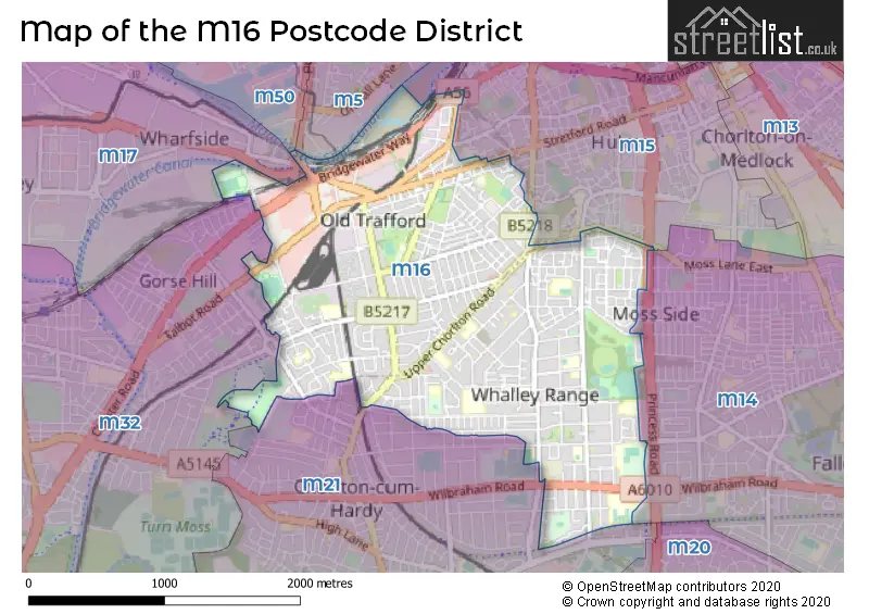
The M16 Postcode shares a border with M21 (MANCHESTER, Chorlton Cum Hardy), M5 (SALFORD), M15 (MANCHESTER, Hulme, Manchester Science Park), M32 (Stretford) and M14 (MANCHESTER, Fallowfield).
The primary settlement in the M16 postcode district is Manchester, which is located in the county of Greater Manchester in England. Other significant settlements in the district include Firswood, Old Trafford, Moss Side, and Whalley Range. The most significant post town in the district is Manchester.
For the district M16, we have data on 5 postcode sectors. Here's a breakdown: The sector M16 0, covers Manchester and Old Trafford in Greater Manchester. The sector M16 6 is non-geographic. It's often designated for PO Boxes, large organisations, or special services. The sector M16 7, covers Manchester and Old Trafford in Greater Manchester. The sector M16 8, covers Manchester in Greater Manchester. The sector M16 9, covers Manchester and Old Trafford in Greater Manchester.


Map of the M16 Postcode District
Explore the M16 postcode district by using our free interactive map.
When it comes to local government, postal geography often disregards political borders. However, for a breakdown in the M16 District: the district mostly encompasses the Trafford District (B) (467 postcodes), and finally, the Manchester District (B) area (410 postcodes).
Recent House Sales in M16
| Date | Price | Address |
|---|---|---|
| 09/10/2023 | £113,000 | Chester Road, Old Trafford, Manchester, M16 9QX |
| 29/09/2023 | £595,000 | Brooks Road, Manchester, M16 9QW |
| 22/09/2023 | £555,000 | Holwood Drive, Manchester, M16 8WS |
| 22/09/2023 | £375,000 | Caistor Close, Manchester, M16 8NW |
| 22/09/2023 | £555,000 | Holwood Drive, Manchester, M16 8WS |
| 13/09/2023 | £288,805 | Granville Avenue, Manchester, M16 8JX |
| 06/09/2023 | £92,307 | Seymour Grove, Manchester, M16 0YL |
| 06/09/2023 | £92,307 | Seymour Grove, Manchester, M16 0YH |
| 06/09/2023 | £92,307 | Seymour Grove, Manchester, M16 0YL |
| 06/09/2023 | £92,307 | Seymour Grove, Manchester, M16 0YH |
Weather Forecast for M16
Press Button to Show Forecast for Whalley Range
| Time Period | Icon | Description | Temperature | Rain Probability | Wind |
|---|---|---|---|---|---|
| 03:00 to 06:00 | Cloudy | 6.0°C (feels like 3.0°C) | 6.00% | WSW 7 mph | |
| 06:00 to 09:00 | Cloudy | 6.0°C (feels like 4.0°C) | 7.00% | W 7 mph | |
| 09:00 to 12:00 | Overcast | 8.0°C (feels like 6.0°C) | 43.00% | NW 9 mph | |
| 12:00 to 15:00 | Light rain | 8.0°C (feels like 6.0°C) | 49.00% | N 9 mph | |
| 15:00 to 18:00 | Light rain shower (day) | 9.0°C (feels like 8.0°C) | 38.00% | NE 4 mph | |
| 18:00 to 21:00 | Light rain | 9.0°C (feels like 7.0°C) | 49.00% | NNE 7 mph | |
| 21:00 to 00:00 | Cloudy | 7.0°C (feels like 5.0°C) | 8.00% | NE 4 mph |
Press Button to Show Forecast for Whalley Range
| Time Period | Icon | Description | Temperature | Rain Probability | Wind |
|---|---|---|---|---|---|
| 00:00 to 03:00 | Partly cloudy (night) | 5.0°C (feels like 3.0°C) | 2.00% | ENE 7 mph | |
| 03:00 to 06:00 | Partly cloudy (night) | 3.0°C (feels like 2.0°C) | 1.00% | ENE 4 mph | |
| 06:00 to 09:00 | Partly cloudy (day) | 3.0°C (feels like 2.0°C) | 1.00% | ENE 4 mph | |
| 09:00 to 12:00 | Partly cloudy (day) | 7.0°C (feels like 6.0°C) | 2.00% | ENE 4 mph | |
| 12:00 to 15:00 | Overcast | 9.0°C (feels like 8.0°C) | 9.00% | E 4 mph | |
| 15:00 to 18:00 | Cloudy | 10.0°C (feels like 9.0°C) | 7.00% | E 4 mph | |
| 18:00 to 21:00 | Cloudy | 10.0°C (feels like 9.0°C) | 7.00% | NE 4 mph | |
| 21:00 to 00:00 | Partly cloudy (night) | 6.0°C (feels like 4.0°C) | 4.00% | ENE 7 mph |
Press Button to Show Forecast for Whalley Range
| Time Period | Icon | Description | Temperature | Rain Probability | Wind |
|---|---|---|---|---|---|
| 00:00 to 03:00 | Partly cloudy (night) | 4.0°C (feels like 2.0°C) | 6.00% | ENE 4 mph | |
| 03:00 to 06:00 | Partly cloudy (night) | 3.0°C (feels like 1.0°C) | 6.00% | ENE 4 mph | |
| 06:00 to 09:00 | Partly cloudy (day) | 5.0°C (feels like 3.0°C) | 6.00% | ENE 4 mph | |
| 09:00 to 12:00 | Cloudy | 8.0°C (feels like 6.0°C) | 8.00% | E 7 mph | |
| 12:00 to 15:00 | Overcast | 10.0°C (feels like 9.0°C) | 16.00% | E 7 mph | |
| 15:00 to 18:00 | Cloudy | 11.0°C (feels like 9.0°C) | 18.00% | ENE 9 mph | |
| 18:00 to 21:00 | Cloudy | 10.0°C (feels like 8.0°C) | 15.00% | ENE 9 mph | |
| 21:00 to 00:00 | Cloudy | 7.0°C (feels like 5.0°C) | 17.00% | NE 9 mph |
Press Button to Show Forecast for Whalley Range
| Time Period | Icon | Description | Temperature | Rain Probability | Wind |
|---|---|---|---|---|---|
| 00:00 to 03:00 | Cloudy | 6.0°C (feels like 4.0°C) | 16.00% | NE 9 mph | |
| 03:00 to 06:00 | Cloudy | 6.0°C (feels like 4.0°C) | 17.00% | NNE 9 mph | |
| 06:00 to 09:00 | Cloudy | 7.0°C (feels like 4.0°C) | 20.00% | NNE 9 mph | |
| 09:00 to 12:00 | Light rain | 8.0°C (feels like 5.0°C) | 50.00% | NNE 11 mph | |
| 12:00 to 15:00 | Heavy rain | 9.0°C (feels like 6.0°C) | 76.00% | N 11 mph | |
| 15:00 to 18:00 | Light rain | 10.0°C (feels like 7.0°C) | 57.00% | NNE 9 mph | |
| 18:00 to 21:00 | Cloudy | 10.0°C (feels like 8.0°C) | 18.00% | N 9 mph | |
| 21:00 to 00:00 | Partly cloudy (night) | 8.0°C (feels like 6.0°C) | 10.00% | NW 7 mph |
Where is the M16 Postcode District?
The data shows that the M16 postcode district is located in the town of Manchester. It is situated near several nearby towns, including Salford to the north, Sale to the southwest, Cheadle to the southeast, Dukinfield to the east, and Wilmslow to the south. Additionally, the distance from the M16 postcode district to the center of London is approximately 162.08 miles.
The district is within the post town of MANCHESTER.
The sector has postcodes within the nation of England.
The M16 Postcode District is covers the following regions.
- Manchester - Greater Manchester - North West (England)
- Greater Manchester South West - Greater Manchester - North West (England)
- Greater Manchester South East - Greater Manchester - North West (England)
| Postcode Sector | Delivery Office |
|---|---|
| M16 0 | South West (m) Delivery Office |
| M16 7 | South West (m) Delivery Office |
| M16 8 | South West (m) Delivery Office |
| M16 9 | South West (m) Delivery Office |
| M | 1 | 6 | - | X | X | X |
| M | 1 | 6 | Space | Numeric | Letter | Letter |
Tourist Attractions within the Postcode Area
We found 1 visitor attractions within the M16 postcode area
| Manchester United Museum & Tour Centre |
|---|
| Museums & Art Galleries |
| Museum and / or Art Gallery |
| View Manchester United Museum & Tour Centre on Google Maps |
Current Monthly Rental Prices
| # Bedrooms | Min Price | Max Price | Avg Price |
|---|---|---|---|
| £615 | £950 | £783 | |
| 1 | £450 | £1,550 | £807 |
| 2 | £775 | £1,400 | £1,183 |
| 3 | £1,350 | £1,900 | £1,640 |
| 4 | £1,775 | £2,700 | £2,158 |
Current House Prices
| # Bedrooms | Min Price | Max Price | Avg Price |
|---|---|---|---|
| £23,000 | £225,000 | £118,325 | |
| 1 | £29,000 | £240,000 | £148,108 |
| 2 | £130,000 | £520,695 | £248,634 |
| 3 | £200,000 | £660,000 | £366,774 |
| 4 | £299,950 | £650,000 | £439,082 |
| 5 | £320,000 | £775,000 | £532,500 |
| 6 | £425,000 | £800,000 | £655,000 |
| 7 | £475,000 | £475,000 | £475,000 |
| 8 | £725,000 | £725,000 | £725,000 |
Estate Agents who Operate in the M16 District
| Logo | Name | Brand Name | Address | Contact Number | Total Properties |
|---|---|---|---|---|---|
 | Chorlton | Bridgfords | 561 Barlow Moor Road, Chorlton, Manchester, M21 8AN | 0161 524 5067 | 20 |
 | Chorlton | JP & Brimelow | 430 Barlow Moor Road, Chorlton Cum Hardy, Manchester, M21 8AD | 0161 524 5506 | 16 |
 | London | RW Invest | City Point 1 Ropemaker St London EC2Y 9AW | 020 3907 9852 | 15 |
 | Manchester Apartments | Manchester Apartments | 60 Oxford Street, Manchester, M1 5EE | 0161 524 4717 | 11 |
 | Manchester | LPC invest | Regus Digital World 1 Lowry PLaza The Quays, Salford, M50 3UB | 0161 524 5843 | 10 |
| Type of Property | 2018 Average | 2018 Sales | 2017 Average | 2017 Sales | 2016 Average | 2016 Sales | 2015 Average | 2015 Sales |
|---|---|---|---|---|---|---|---|---|
| Detached | £455,042 | 6 | £363,536 | 14 | £320,094 | 16 | £363,943 | 12 |
| Semi-Detached | £304,591 | 115 | £286,018 | 97 | £267,498 | 105 | £253,829 | 112 |
| Terraced | £215,931 | 107 | £241,253 | 118 | £197,763 | 135 | £180,609 | 124 |
| Flats | £144,906 | 311 | £134,776 | 172 | £116,195 | 243 | £102,024 | 231 |