The M19 postcode district is a postal district located in the M Manchester postcode area with a population of 37,405 residents according to the 2021 England and Wales Census.
The area of the M19 postcode district is 2.13 square miles which is 5.52 square kilometres or 1,364.26 acres.
Currently, the M19 district has about 807 postcode units spread across 3 geographic postcode sectors.
Given that each sector allows for 400 unique postcode combinations, the district has a capacity of 1,200 postcodes. With 807 postcodes already in use, this leaves 393 units available.
The largest settlements in the M19 postal code are MANCHESTER and Levenshulme.
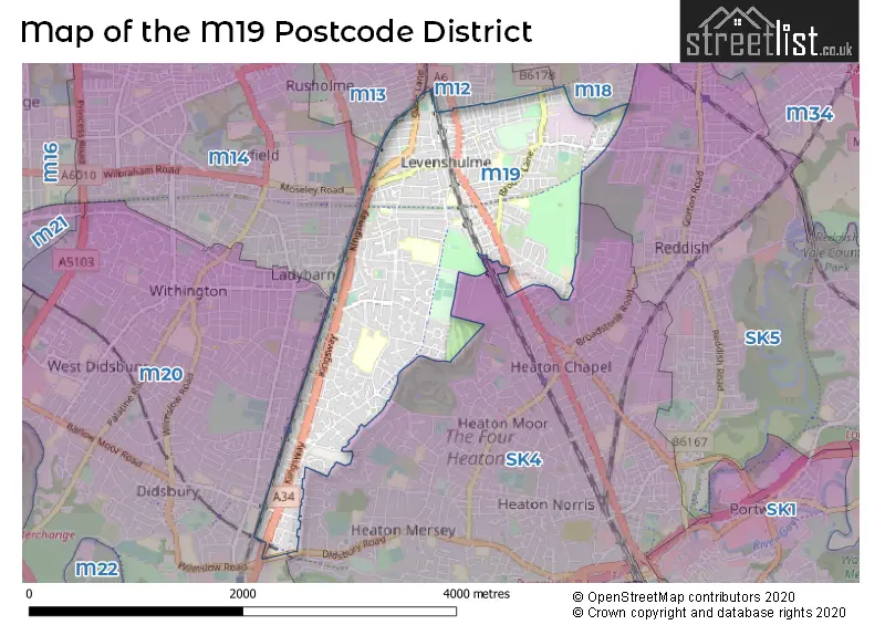
The M19 Postcode shares a border with SK5 (STOCKPORT, Reddish), M18 (MANCHESTER, Abbey Hey, Gorton), M20 (MANCHESTER, Withington, Didsbury), SK4 (STOCKPORT), M12 (MANCHESTER, Longsight, Ardwick) and M13 (MANCHESTER).
The primary settlement in the M19 postcode district is Manchester, located in Greater Manchester, England. Other significant settlements in the district include Burnage and Levenshulme. The main post town in the district is Manchester.
For the district M19, we have data on 4 postcode sectors. Here's a breakdown: The sector M19 0 is non-geographic. It's often designated for PO Boxes, large organisations, or special services. The sector M19 1, covers Manchester in Greater Manchester. The sector M19 2, covers Manchester in Greater Manchester. The sector M19 3, covers Manchester and Levenshulme in Greater Manchester.


Map of the M19 Postcode District
Explore the M19 postcode district by using our free interactive map.
When it comes to local government, postal geography often disregards political borders. However, for a breakdown in the M19 District: the district mostly encompasses the Manchester District (B) (792 postcodes), and finally, the Stockport District (B) area (14 postcodes).
Recent House Sales in M19
| Date | Price | Address |
|---|---|---|
| 10/10/2023 | £210,000 | King Edward Street, Manchester, M19 3FY |
| 09/10/2023 | £100,000 | Henderson Street, Manchester, M19 2QR |
| 22/09/2023 | £372,500 | Kinburn Road, Manchester, M19 1RH |
| 15/09/2023 | £110,000 | Rushford Avenue, Manchester, M19 2FE |
| 11/09/2023 | £250,000 | Kingsway, Manchester, M19 2BZ |
| 31/08/2023 | £325,000 | Broadlea Road, Manchester, M19 1BG |
| 30/08/2023 | £280,000 | Lavister Avenue, Manchester, M19 1RT |
| 30/08/2023 | £411,000 | Lynnwood Road, Manchester, M19 1RJ |
| 25/08/2023 | £250,000 | Western Circle, Manchester, M19 1HH |
| 25/08/2023 | £74,950 | Byrom Parade, Manchester, M19 3HH |
Weather Forecast for M19
Press Button to Show Forecast for Burnage
| Time Period | Icon | Description | Temperature | Rain Probability | Wind |
|---|---|---|---|---|---|
| 06:00 to 09:00 | Cloudy | 8.0°C (feels like 5.0°C) | 15.00% | NW 13 mph | |
| 09:00 to 12:00 | Cloudy | 10.0°C (feels like 6.0°C) | 39.00% | NW 16 mph | |
| 12:00 to 15:00 | Cloudy | 11.0°C (feels like 8.0°C) | 37.00% | NW 13 mph | |
| 15:00 to 18:00 | Light rain shower (day) | 11.0°C (feels like 9.0°C) | 58.00% | NW 11 mph | |
| 18:00 to 21:00 | Cloudy | 10.0°C (feels like 8.0°C) | 5.00% | N 11 mph | |
| 21:00 to 00:00 | Clear night | 7.0°C (feels like 6.0°C) | 1.00% | NE 7 mph |
Press Button to Show Forecast for Burnage
| Time Period | Icon | Description | Temperature | Rain Probability | Wind |
|---|---|---|---|---|---|
| 00:00 to 03:00 | Partly cloudy (night) | 6.0°C (feels like 4.0°C) | 1.00% | NE 4 mph | |
| 03:00 to 06:00 | Partly cloudy (night) | 4.0°C (feels like 3.0°C) | 1.00% | N 4 mph | |
| 06:00 to 09:00 | Sunny day | 4.0°C (feels like 3.0°C) | 1.00% | N 4 mph | |
| 09:00 to 12:00 | Sunny day | 7.0°C (feels like 6.0°C) | 1.00% | N 4 mph | |
| 12:00 to 15:00 | Cloudy | 10.0°C (feels like 9.0°C) | 5.00% | N 7 mph | |
| 15:00 to 18:00 | Cloudy | 11.0°C (feels like 10.0°C) | 6.00% | NNW 7 mph | |
| 18:00 to 21:00 | Cloudy | 11.0°C (feels like 9.0°C) | 5.00% | NNW 7 mph | |
| 21:00 to 00:00 | Clear night | 8.0°C (feels like 6.0°C) | 1.00% | N 4 mph |
Press Button to Show Forecast for Burnage
| Time Period | Icon | Description | Temperature | Rain Probability | Wind |
|---|---|---|---|---|---|
| 00:00 to 03:00 | Partly cloudy (night) | 6.0°C (feels like 5.0°C) | 2.00% | N 4 mph | |
| 03:00 to 06:00 | Cloudy | 5.0°C (feels like 4.0°C) | 6.00% | N 2 mph | |
| 06:00 to 09:00 | Cloudy | 6.0°C (feels like 5.0°C) | 13.00% | ESE 2 mph | |
| 09:00 to 12:00 | Cloudy | 9.0°C (feels like 8.0°C) | 8.00% | NNE 2 mph | |
| 12:00 to 15:00 | Light rain | 11.0°C (feels like 10.0°C) | 49.00% | NE 7 mph | |
| 15:00 to 18:00 | Cloudy | 12.0°C (feels like 10.0°C) | 15.00% | NE 7 mph | |
| 18:00 to 21:00 | Cloudy | 11.0°C (feels like 9.0°C) | 6.00% | NE 7 mph | |
| 21:00 to 00:00 | Cloudy | 8.0°C (feels like 7.0°C) | 4.00% | ENE 7 mph |
Press Button to Show Forecast for Burnage
| Time Period | Icon | Description | Temperature | Rain Probability | Wind |
|---|---|---|---|---|---|
| 00:00 to 03:00 | Partly cloudy (night) | 7.0°C (feels like 5.0°C) | 3.00% | E 4 mph | |
| 03:00 to 06:00 | Overcast | 5.0°C (feels like 4.0°C) | 9.00% | E 4 mph | |
| 06:00 to 09:00 | Cloudy | 6.0°C (feels like 5.0°C) | 7.00% | ENE 4 mph | |
| 09:00 to 12:00 | Overcast | 9.0°C (feels like 7.0°C) | 10.00% | ENE 7 mph | |
| 12:00 to 15:00 | Cloudy | 10.0°C (feels like 9.0°C) | 8.00% | ENE 7 mph | |
| 15:00 to 18:00 | Cloudy | 11.0°C (feels like 9.0°C) | 15.00% | NE 7 mph | |
| 18:00 to 21:00 | Cloudy | 10.0°C (feels like 9.0°C) | 15.00% | NE 7 mph | |
| 21:00 to 00:00 | Partly cloudy (night) | 7.0°C (feels like 6.0°C) | 3.00% | ENE 7 mph |
Where is the M19 Postcode District?
The postcode district M19 is located in the town of Manchester. Nearby towns include Stockport, Cheadle, Hyde, Dukinfield, Salford, and Sale. The distance from M19 to London is approximately 159.32 miles.
The district is within the post town of MANCHESTER.
The sector has postcodes within the nation of England.
The M19 Postcode District is covers the following regions.
- Manchester - Greater Manchester - North West (England)
- Greater Manchester South East - Greater Manchester - North West (England)
| Postcode Sector | Delivery Office |
|---|---|
| M19 1 | Levenshulme Delivery Office |
| M19 2 | Levenshulme Delivery Office |
| M19 3 | Levenshulme Delivery Office |
| M | 1 | 9 | - | X | X | X |
| M | 1 | 9 | Space | Numeric | Letter | Letter |
Current Monthly Rental Prices
| # Bedrooms | Min Price | Max Price | Avg Price |
|---|---|---|---|
| £1,000 | £1,000 | £1,000 | |
| 1 | £545 | £1,495 | £793 |
| 2 | £800 | £1,800 | £1,221 |
| 3 | £1,250 | £1,700 | £1,400 |
| 4 | £1,907 | £1,907 | £1,907 |
| 6 | £3,900 | £3,900 | £3,900 |
| 8 | £545 | £545 | £545 |
Current House Prices
| # Bedrooms | Min Price | Max Price | Avg Price |
|---|---|---|---|
| 1 | £60,000 | £120,000 | £91,111 |
| 2 | £150,000 | £290,000 | £201,883 |
| 3 | £102,500 | £500,000 | £310,689 |
| 4 | £260,000 | £499,995 | £384,043 |
| 5 | £290,000 | £350,000 | £330,000 |
| 6 | £460,000 | £460,000 | £460,000 |
| 9 | £350,000 | £350,000 | £350,000 |
| 10 | £750,000 | £750,000 | £750,000 |
| 16 | £1,500,000 | £1,500,000 | £1,500,000 |
Estate Agents who Operate in the M19 District
| Logo | Name | Brand Name | Address | Contact Number | Total Properties |
|---|---|---|---|---|---|
 | Levenshulme | Edward Mellor Ltd | 918 Stockport Road, Levenshulme, Manchester, M19 3AB | 0161 524 5302 | 35 |
 | Manchester | Peter Anthony | 834 Stockport Road, Manchester, M19 3AW | 0161 524 5024 | 12 |
 | Didsbury | Julian Wadden | 764b Wilmslow Road, Didsbury, Manchester, M20 2DR | 0161 524 9950 | 9 |
 | Didsbury | Reeds Rains | 713 Wilmslow Road, Manchester, M20 6RE | 0161 524 2267 | 7 |
 | Manchester | Lancashire Properties | 967 Stockport Road, Levenshulme, Manchester, M19 3NP | 0161 524 7921 | 7 |
| Type of Property | 2018 Average | 2018 Sales | 2017 Average | 2017 Sales | 2016 Average | 2016 Sales | 2015 Average | 2015 Sales |
|---|---|---|---|---|---|---|---|---|
| Detached | £290,083 | 6 | £218,282 | 14 | £143,297 | 8 | £234,656 | 16 |
| Semi-Detached | £219,465 | 221 | £206,219 | 225 | £184,325 | 212 | £168,110 | 181 |
| Terraced | £155,465 | 254 | £143,505 | 259 | £127,342 | 255 | £116,577 | 235 |
| Flats | £125,748 | 42 | £100,722 | 50 | £109,630 | 61 | £94,826 | 48 |
Hotels within the Postcode Area
We found 1 hotels and guest houses within the M19 postcode area