The M22 postcode district is a postal district located in the M Manchester postcode area with a population of 45,590 residents according to the 2021 England and Wales Census.
The area of the M22 postcode district is 4.61 square miles which is 11.93 square kilometres or 2,947.47 acres.
Currently, the M22 district has about 1213 postcode units spread across 6 geographic postcode sectors.
Given that each sector allows for 400 unique postcode combinations, the district has a capacity of 2,400 postcodes. With 1213 postcodes already in use, this leaves 1187 units available.
The largest settlements in the M22 postal code are MANCHESTER and Wythenshawe.
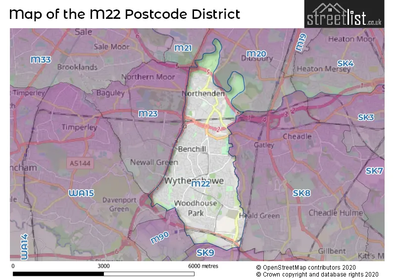
The M22 Postcode shares a border with WA15 (Timperley, Hale, Hale Barns), M23 (MANCHESTER, Roundthorn Industrial Estate, Wythenshawe), M90 (Manchester Airport, Airport City), SK8 (Cheadle Hulme, CHEADLE, Heald Green) and M20 (MANCHESTER, Withington, Didsbury).
The primary settlement in the M22 postcode district is Manchester, which is located in the county of Greater Manchester. Other significant settlements include Wythenshawe. The M22 postcode district is primarily associated with the post town of Manchester.
For the district M22, we have data on 7 postcode sectors. Here's a breakdown: The sector M22 0, covers Manchester in Greater Manchester. The sector M22 1, covers Manchester in Greater Manchester. The sector M22 2 is non-geographic. It's often designated for PO Boxes, large organisations, or special services. The sector M22 4, covers Manchester in Greater Manchester. The sector M22 5, covers Manchester in Greater Manchester. The sector M22 8, covers Manchester and Wythenshawe in Greater Manchester. The sector M22 9, covers Manchester in Greater Manchester.


Map of the M22 Postcode District
Explore the M22 postcode district by using our free interactive map.
When it comes to local government, postal geography often disregards political borders. However, for a breakdown in the M22 District: the district mostly encompasses the Manchester District (B) area with a total of 1213 postcodes.
Recent House Sales in M22
| Date | Price | Address |
|---|---|---|
| 22/09/2023 | £105,000 | Painswick Road, Manchester, M22 1EQ |
| 22/09/2023 | £335,000 | Kenworthy Lane, Manchester, M22 4EJ |
| 12/09/2023 | £165,000 | Royalthorn Road, Manchester, M22 8AD |
| 11/09/2023 | £110,000 | Cotefield Road, Manchester, M22 1UG |
| 01/09/2023 | £148,950 | Brett Street, Manchester, M22 4EZ |
| 01/09/2023 | £255,000 | Hilton Road, Manchester, M22 4ZD |
| 01/09/2023 | £195,000 | Ashmoor Road, Manchester, M22 0FD |
| 31/08/2023 | £213,000 | Hopton Avenue, Manchester, M22 5BY |
| 29/08/2023 | £218,500 | Ellenbrook Road, Manchester, M22 1JH |
| 29/08/2023 | £290,000 | Downes Way, Manchester, M22 4UD |
Weather Forecast for M22
Press Button to Show Forecast for Wythenshawe
| Time Period | Icon | Description | Temperature | Rain Probability | Wind |
|---|---|---|---|---|---|
| 12:00 to 15:00 | Light rain | 8.0°C (feels like 6.0°C) | 49.00% | N 7 mph | |
| 15:00 to 18:00 | Cloudy | 9.0°C (feels like 7.0°C) | 9.00% | ENE 4 mph | |
| 18:00 to 21:00 | Light rain | 9.0°C (feels like 7.0°C) | 52.00% | NNE 4 mph | |
| 21:00 to 00:00 | Cloudy | 6.0°C (feels like 5.0°C) | 43.00% | NE 4 mph |
Press Button to Show Forecast for Wythenshawe
| Time Period | Icon | Description | Temperature | Rain Probability | Wind |
|---|---|---|---|---|---|
| 00:00 to 03:00 | Partly cloudy (night) | 5.0°C (feels like 2.0°C) | 2.00% | E 7 mph | |
| 03:00 to 06:00 | Partly cloudy (night) | 3.0°C (feels like 1.0°C) | 2.00% | ENE 4 mph | |
| 06:00 to 09:00 | Sunny day | 3.0°C (feels like 1.0°C) | 1.00% | ENE 4 mph | |
| 09:00 to 12:00 | Partly cloudy (day) | 7.0°C (feels like 6.0°C) | 2.00% | NE 4 mph | |
| 12:00 to 15:00 | Overcast | 9.0°C (feels like 8.0°C) | 9.00% | E 4 mph | |
| 15:00 to 18:00 | Cloudy | 10.0°C (feels like 9.0°C) | 6.00% | E 4 mph | |
| 18:00 to 21:00 | Cloudy | 9.0°C (feels like 8.0°C) | 6.00% | NE 4 mph | |
| 21:00 to 00:00 | Partly cloudy (night) | 6.0°C (feels like 4.0°C) | 4.00% | ENE 7 mph |
Press Button to Show Forecast for Wythenshawe
| Time Period | Icon | Description | Temperature | Rain Probability | Wind |
|---|---|---|---|---|---|
| 00:00 to 03:00 | Partly cloudy (night) | 4.0°C (feels like 2.0°C) | 6.00% | ENE 4 mph | |
| 03:00 to 06:00 | Partly cloudy (night) | 3.0°C (feels like 1.0°C) | 7.00% | ENE 4 mph | |
| 06:00 to 09:00 | Cloudy | 4.0°C (feels like 2.0°C) | 9.00% | ENE 4 mph | |
| 09:00 to 12:00 | Partly cloudy (day) | 8.0°C (feels like 6.0°C) | 4.00% | E 7 mph | |
| 12:00 to 15:00 | Overcast | 10.0°C (feels like 8.0°C) | 16.00% | E 7 mph | |
| 15:00 to 18:00 | Light rain | 10.0°C (feels like 8.0°C) | 45.00% | E 9 mph | |
| 18:00 to 21:00 | Cloudy | 10.0°C (feels like 8.0°C) | 15.00% | ENE 9 mph | |
| 21:00 to 00:00 | Cloudy | 7.0°C (feels like 5.0°C) | 14.00% | NE 9 mph |
Press Button to Show Forecast for Wythenshawe
| Time Period | Icon | Description | Temperature | Rain Probability | Wind |
|---|---|---|---|---|---|
| 00:00 to 03:00 | Cloudy | 6.0°C (feels like 3.0°C) | 15.00% | NE 9 mph | |
| 03:00 to 06:00 | Cloudy | 6.0°C (feels like 3.0°C) | 18.00% | NE 9 mph | |
| 06:00 to 09:00 | Light rain | 7.0°C (feels like 4.0°C) | 49.00% | NNE 9 mph | |
| 09:00 to 12:00 | Light rain | 8.0°C (feels like 5.0°C) | 50.00% | NNE 11 mph | |
| 12:00 to 15:00 | Heavy rain | 9.0°C (feels like 6.0°C) | 77.00% | NNE 11 mph | |
| 15:00 to 18:00 | Heavy rain | 10.0°C (feels like 7.0°C) | 76.00% | NNE 9 mph | |
| 18:00 to 21:00 | Light rain shower (day) | 10.0°C (feels like 8.0°C) | 37.00% | NNE 9 mph | |
| 21:00 to 00:00 | Partly cloudy (night) | 7.0°C (feels like 6.0°C) | 12.00% | NNW 7 mph |
Where is the M22 Postcode District?
The postcode district M22 is located in the town of Manchester. It is situated near several other towns, including Cheadle to the East (1.95 miles away), Sale to the North West (3.70 miles away), Wilmslow to the South (3.97 miles away), Altrincham to the West (4.36 miles away), Knutsford to the South West (6.94 miles away), and Salford to the North (7.47 miles away). Additionally, the distance from M22 to the center of London is approximately 157.96 miles.
The district is within the post town of MANCHESTER.
The sector has postcodes within the nation of England.
The M22 Postcode District is in the Manchester region of Greater Manchester within the North West (England).
| Postcode Sector | Delivery Office |
|---|---|
| M22 0 | Wythenshawe Delivery Office |
| M22 1 | Wythenshawe Delivery Office |
| M22 4 | Wythenshawe Delivery Office |
| M22 5 | Wythenshawe Delivery Office |
| M22 8 | Wythenshawe Delivery Office |
| M22 9 | Wythenshawe Delivery Office |
| M | 2 | 2 | - | X | X | X |
| M | 2 | 2 | Space | Numeric | Letter | Letter |
Current Monthly Rental Prices
| # Bedrooms | Min Price | Max Price | Avg Price |
|---|---|---|---|
| £150 | £150 | £150 | |
| 1 | £725 | £725 | £725 |
| 2 | £900 | £1,290 | £1,062 |
| 3 | £1,000 | £2,000 | £1,388 |
| 4 | £1,995 | £2,100 | £2,048 |
Current House Prices
| # Bedrooms | Min Price | Max Price | Avg Price |
|---|---|---|---|
| £250,000 | £250,000 | £250,000 | |
| 1 | £80,000 | £135,000 | £116,667 |
| 2 | £115,000 | £350,000 | £209,521 |
| 3 | £150,000 | £575,000 | £278,087 |
| 4 | £189,995 | £650,000 | £407,904 |
| 5 | £375,000 | £950,000 | £662,500 |
| 6 | £599,000 | £599,000 | £599,000 |
Estate Agents who Operate in the M22 District
| Logo | Name | Brand Name | Address | Contact Number | Total Properties |
|---|---|---|---|---|---|
 | Heald Green | Main & Main | 198 Finney Lane, Heald Green, Cheadle, SK8 3QA | 0161 524 2114 | 15 |
 | Manchester | Northern Etchells | 53a Church Road, Gatley, Cheadle, SK8 4NG | 0161 498 0049 | 13 |
 | Heald Green | Roger Dean | 218 Finney Lane, Heald Green, SK8 3QA | 0161 524 7423 | 10 |
 | Manchester | Bergins Estate Agents | 22 Royle Green Road, Northenden, Wythenshawe, Manchester, M22 4NG | 0161 524 6967 | 8 |
 | South Manchester | Hunters | 372 Palatine Road, Manchester, M22 4FZ | 0161 524 5750 | 8 |
| Type of Property | 2018 Average | 2018 Sales | 2017 Average | 2017 Sales | 2016 Average | 2016 Sales | 2015 Average | 2015 Sales |
|---|---|---|---|---|---|---|---|---|
| Detached | £296,541 | 35 | £287,773 | 32 | £276,500 | 34 | £250,186 | 38 |
| Semi-Detached | £184,959 | 193 | £173,631 | 206 | £167,017 | 178 | £162,550 | 163 |
| Terraced | £155,066 | 167 | £151,376 | 175 | £152,792 | 232 | £132,143 | 230 |
| Flats | £121,871 | 98 | £133,747 | 128 | £109,343 | 115 | £105,563 | 78 |