The M23 postcode district is a postal district located in the M Manchester postcode area with a population of 32,753 residents according to the 2021 England and Wales Census.
The area of the M23 postcode district is 3.30 square miles which is 8.55 square kilometres or 2,113.62 acres.
Currently, the M23 district has about 814 postcode units spread across 4 geographic postcode sectors.
Given that each sector allows for 400 unique postcode combinations, the district has a capacity of 1,600 postcodes. With 814 postcodes already in use, this leaves 786 units available.
The largest settlement in the M23 postal code is MANCHESTER followed by Roundthorn Industrial Estate, and Wythenshawe.
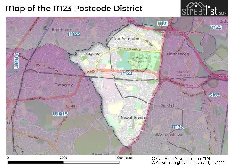
The M23 Postcode shares a border with WA15 (Timperley, Hale, Hale Barns), M22 (MANCHESTER, Wythenshawe), M21 (MANCHESTER, Chorlton Cum Hardy) and M33 (SALE).
The primary settlement in the M23 postcode district is Manchester, located in the county of Greater Manchester in England. Other significant settlements include Wythenshawe and Baguley. The most significant post town in the M23 postcode district is Manchester.
For the district M23, we have data on 4 postcode sectors. Here's a breakdown: The sector M23 0, covers Manchester in Greater Manchester. The sector M23 1, covers Manchester in Greater Manchester. The sector M23 2, covers Manchester in Greater Manchester. The sector M23 9, covers Manchester and Roundthorn Industrial Estate in Greater Manchester.

Map of the M23 Postcode District
Explore the M23 postcode district by using our free interactive map.
When it comes to local government, postal geography often disregards political borders. However, for a breakdown in the M23 District: the district mostly encompasses the Manchester District (B) (808 postcodes), and finally, the Trafford District (B) area (9 postcodes).
Recent House Sales in M23
| Date | Price | Address |
|---|---|---|
| 16/10/2023 | £345,000 | Kerscott Road, Manchester, M23 0GP |
| 16/10/2023 | £170,000 | Parklands Road, Manchester, M23 0GB |
| 13/10/2023 | £122,250 | Oakcliffe Road, Manchester, M23 1DA |
| 12/10/2023 | £250,000 | Bideford Drive, Manchester, M23 0QH |
| 06/10/2023 | £235,000 | Heyland Road, Manchester, M23 1HE |
| 03/10/2023 | £325,000 | Lawnhurst Avenue, Wythenshawe, Manchester, M23 9RY |
| 29/09/2023 | £68,000 | Glebelands Road, Manchester, M23 1HR |
| 11/09/2023 | £270,000 | Altrincham Road, Manchester, M23 1DW |
| 07/09/2023 | £144,000 | Hall Lane, Manchester, M23 1DL |
| 06/09/2023 | £177,000 | Hall Lane, Manchester, M23 1WA |
Weather Forecast for M23
Press Button to Show Forecast for Baguley
| Time Period | Icon | Description | Temperature | Rain Probability | Wind |
|---|---|---|---|---|---|
| 12:00 to 15:00 | Light rain | 8.0°C (feels like 6.0°C) | 49.00% | N 7 mph | |
| 15:00 to 18:00 | Cloudy | 9.0°C (feels like 8.0°C) | 8.00% | NE 4 mph | |
| 18:00 to 21:00 | Light rain | 9.0°C (feels like 8.0°C) | 52.00% | NNE 4 mph | |
| 21:00 to 00:00 | Cloudy | 6.0°C (feels like 5.0°C) | 12.00% | NE 4 mph |
Press Button to Show Forecast for Baguley
| Time Period | Icon | Description | Temperature | Rain Probability | Wind |
|---|---|---|---|---|---|
| 00:00 to 03:00 | Partly cloudy (night) | 5.0°C (feels like 3.0°C) | 2.00% | E 4 mph | |
| 03:00 to 06:00 | Partly cloudy (night) | 3.0°C (feels like 1.0°C) | 1.00% | ENE 4 mph | |
| 06:00 to 09:00 | Sunny day | 3.0°C (feels like 2.0°C) | 1.00% | ENE 4 mph | |
| 09:00 to 12:00 | Partly cloudy (day) | 7.0°C (feels like 6.0°C) | 2.00% | NE 4 mph | |
| 12:00 to 15:00 | Overcast | 9.0°C (feels like 8.0°C) | 9.00% | E 4 mph | |
| 15:00 to 18:00 | Cloudy | 10.0°C (feels like 9.0°C) | 6.00% | E 4 mph | |
| 18:00 to 21:00 | Cloudy | 9.0°C (feels like 9.0°C) | 6.00% | NE 4 mph | |
| 21:00 to 00:00 | Partly cloudy (night) | 6.0°C (feels like 4.0°C) | 4.00% | ENE 7 mph |
Press Button to Show Forecast for Baguley
| Time Period | Icon | Description | Temperature | Rain Probability | Wind |
|---|---|---|---|---|---|
| 00:00 to 03:00 | Partly cloudy (night) | 4.0°C (feels like 2.0°C) | 6.00% | ENE 4 mph | |
| 03:00 to 06:00 | Partly cloudy (night) | 3.0°C (feels like 1.0°C) | 7.00% | ENE 4 mph | |
| 06:00 to 09:00 | Cloudy | 5.0°C (feels like 2.0°C) | 9.00% | ENE 4 mph | |
| 09:00 to 12:00 | Partly cloudy (day) | 8.0°C (feels like 6.0°C) | 4.00% | E 7 mph | |
| 12:00 to 15:00 | Overcast | 10.0°C (feels like 8.0°C) | 16.00% | E 7 mph | |
| 15:00 to 18:00 | Light rain | 10.0°C (feels like 8.0°C) | 45.00% | E 9 mph | |
| 18:00 to 21:00 | Cloudy | 10.0°C (feels like 8.0°C) | 15.00% | ENE 9 mph | |
| 21:00 to 00:00 | Cloudy | 7.0°C (feels like 5.0°C) | 14.00% | NE 9 mph |
Press Button to Show Forecast for Baguley
| Time Period | Icon | Description | Temperature | Rain Probability | Wind |
|---|---|---|---|---|---|
| 00:00 to 03:00 | Cloudy | 6.0°C (feels like 3.0°C) | 15.00% | NE 9 mph | |
| 03:00 to 06:00 | Cloudy | 6.0°C (feels like 4.0°C) | 18.00% | NE 9 mph | |
| 06:00 to 09:00 | Light rain | 7.0°C (feels like 4.0°C) | 49.00% | NNE 9 mph | |
| 09:00 to 12:00 | Light rain | 8.0°C (feels like 5.0°C) | 50.00% | NNE 11 mph | |
| 12:00 to 15:00 | Heavy rain | 9.0°C (feels like 6.0°C) | 77.00% | NNE 11 mph | |
| 15:00 to 18:00 | Heavy rain | 10.0°C (feels like 7.0°C) | 76.00% | NNE 9 mph | |
| 18:00 to 21:00 | Light rain shower (day) | 10.0°C (feels like 8.0°C) | 37.00% | NNE 9 mph | |
| 21:00 to 00:00 | Partly cloudy (night) | 7.0°C (feels like 6.0°C) | 12.00% | NNW 7 mph |
Where is the M23 Postcode District?
The postcode district M23 is located in Manchester. It is a district town in the North West region of England. Nearby towns to M23 include Sale, Altrincham, Cheadle, Wilmslow, Salford, Alderley Edge, and Knutsford. M23 is approximately 159.4 miles away from the center of London.
The district is within the post town of MANCHESTER.
The sector has postcodes within the nation of England.
The M23 Postcode District is covers the following regions.
- Manchester - Greater Manchester - North West (England)
- Greater Manchester South West - Greater Manchester - North West (England)
| Postcode Sector | Delivery Office |
|---|---|
| M23 0 | Wythenshawe Delivery Office |
| M23 1 | Wythenshawe Delivery Office |
| M23 2 | Wythenshawe Delivery Office |
| M23 9 | Wythenshawe Delivery Office |
| M | 2 | 3 | - | X | X | X |
| M | 2 | 3 | Space | Numeric | Letter | Letter |
Current Monthly Rental Prices
| # Bedrooms | Min Price | Max Price | Avg Price |
|---|---|---|---|
| 2 | £980 | £1,100 | £1,040 |
| 3 | £1,000 | £1,800 | £1,350 |
| 4 | £1,600 | £1,600 | £1,600 |
Current House Prices
| # Bedrooms | Min Price | Max Price | Avg Price |
|---|---|---|---|
| £100,000 | £100,000 | £100,000 | |
| 1 | £70,000 | £180,000 | £99,250 |
| 2 | £100,000 | £340,000 | £197,939 |
| 3 | £160,000 | £450,000 | £296,102 |
| 4 | £315,000 | £525,000 | £418,933 |
| 5 | £450,000 | £1,250,000 | £668,750 |
| 6 | £900,000 | £900,000 | £900,000 |
Estate Agents who Operate in the M23 District
| Logo | Name | Brand Name | Address | Contact Number | Total Properties |
|---|---|---|---|---|---|
 | Manchester | Northern Etchells | 53a Church Road, Gatley, Cheadle, SK8 4NG | 0161 498 0049 | 10 |
 | Sale | Bridgfords | 81-83 School Road Sale M33 7XA | 0161 524 8210 | 9 |
 | Sale | Reeds Rains | 76 School Road, Sale, M33 7XB | 0161 524 2994 | 8 |
 | South Manchester | Hunters | 372 Palatine Road, Manchester, M22 4FZ | 0161 524 5750 | 7 |
 | Sale | Gascoigne Halman | 96 School Road, Sale, M33 7XB | 0161 524 1077 | 7 |
| Type of Property | 2018 Average | 2018 Sales | 2017 Average | 2017 Sales | 2016 Average | 2016 Sales | 2015 Average | 2015 Sales |
|---|---|---|---|---|---|---|---|---|
| Detached | £327,469 | 36 | £286,146 | 48 | £295,232 | 41 | £250,682 | 38 |
| Semi-Detached | £175,882 | 169 | £169,673 | 160 | £155,809 | 129 | £152,090 | 151 |
| Terraced | £158,373 | 145 | £149,946 | 125 | £132,636 | 153 | £132,406 | 192 |
| Flats | £119,238 | 97 | £114,814 | 102 | £102,051 | 82 | £93,674 | 61 |