The M32 postcode district is a postal district located in the M Manchester postcode area with a population of 29,500 residents according to the 2021 England and Wales Census.
The area of the M32 postcode district is 3.29 square miles which is 8.52 square kilometres or 2,104.84 acres.
Currently, the M32 district has about 679 postcode units spread across 3 geographic postcode sectors.
Given that each sector allows for 400 unique postcode combinations, the district has a capacity of 1,200 postcodes. With 679 postcodes already in use, this leaves 521 units available.
The M32 postal code covers the settlement of Stretford.
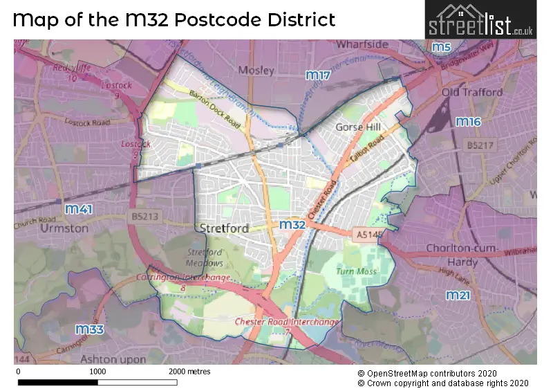
The M32 Postcode shares a border with M16 (MANCHESTER, Old Trafford, Whalley Range), M21 (MANCHESTER, Chorlton Cum Hardy), M17 (Trafford Park, The Trafford Centre, MANCHESTER), M33 (SALE) and M41 (Urmston).
The primary settlement in the M32 postcode district is Stretford, located in Greater Manchester, England. The most significant post town for this postcode district is Manchester.
For the district M32, we have data on 4 postcode sectors. Here's a breakdown: The sector M32 0, covers Stretford in Greater Manchester. The sector M32 2 is non-geographic. It's often designated for PO Boxes, large organisations, or special services. The sector M32 8, covers Stretford in Greater Manchester. The sector M32 9, covers Stretford in Greater Manchester.

Map of the M32 Postcode District
Explore the M32 postcode district by using our free interactive map.
When it comes to local government, postal geography often disregards political borders. However, for a breakdown in the M32 District: the district mostly encompasses the Trafford District (B) area with a total of 687 postcodes.
Recent House Sales in M32
| Date | Price | Address |
|---|---|---|
| 25/09/2023 | £150,000 | Edge Lane, Stretford, Manchester, M32 8PX |
| 18/09/2023 | £265,000 | Berkeley Avenue, Stretford, Manchester, M32 9TJ |
| 07/09/2023 | £1,219,575 | Brightgate Way, Stretford, Manchester, M32 0TB |
| 01/09/2023 | £395,000 | Mayfield Avenue, Stretford, Manchester, M32 9HL |
| 30/08/2023 | £661,000 | Norwood Road, Stretford, Manchester, M32 8PP |
| 25/08/2023 | £260,000 | Lesley Road, Stretford, Manchester, M32 9EE |
| 21/08/2023 | £285,000 | Ashbourne Road, Stretford, Manchester, M32 9RZ |
| 21/08/2023 | £290,000 | Barkway Road, Stretford, Manchester, M32 9DU |
| 21/08/2023 | £310,000 | Jackson Street, Stretford, Manchester, M32 8BB |
| 18/08/2023 | £215,000 | Gorse Street, Stretford, Manchester, M32 0HZ |
Weather Forecast for M32
Press Button to Show Forecast for Stretford
| Time Period | Icon | Description | Temperature | Rain Probability | Wind |
|---|---|---|---|---|---|
| 18:00 to 21:00 | Cloudy | 11.0°C (feels like 9.0°C) | 5.00% | NNE 9 mph | |
| 21:00 to 00:00 | Cloudy | 9.0°C (feels like 8.0°C) | 4.00% | NNE 4 mph |
Press Button to Show Forecast for Stretford
| Time Period | Icon | Description | Temperature | Rain Probability | Wind |
|---|---|---|---|---|---|
| 00:00 to 03:00 | Cloudy | 8.0°C (feels like 6.0°C) | 6.00% | NE 4 mph | |
| 03:00 to 06:00 | Partly cloudy (night) | 7.0°C (feels like 5.0°C) | 1.00% | N 4 mph | |
| 06:00 to 09:00 | Sunny day | 5.0°C (feels like 3.0°C) | 0.00% | NNE 7 mph | |
| 09:00 to 12:00 | Partly cloudy (day) | 7.0°C (feels like 5.0°C) | 0.00% | N 7 mph | |
| 12:00 to 15:00 | Partly cloudy (day) | 10.0°C (feels like 9.0°C) | 0.00% | N 7 mph | |
| 15:00 to 18:00 | Cloudy | 12.0°C (feels like 10.0°C) | 4.00% | NW 9 mph | |
| 18:00 to 21:00 | Partly cloudy (day) | 10.0°C (feels like 8.0°C) | 1.00% | NW 9 mph | |
| 21:00 to 00:00 | Partly cloudy (night) | 7.0°C (feels like 6.0°C) | 1.00% | NNW 4 mph |
Press Button to Show Forecast for Stretford
| Time Period | Icon | Description | Temperature | Rain Probability | Wind |
|---|---|---|---|---|---|
| 00:00 to 03:00 | Partly cloudy (night) | 6.0°C (feels like 4.0°C) | 1.00% | W 4 mph | |
| 03:00 to 06:00 | Cloudy | 6.0°C (feels like 4.0°C) | 4.00% | W 7 mph | |
| 06:00 to 09:00 | Cloudy | 6.0°C (feels like 4.0°C) | 6.00% | W 7 mph | |
| 09:00 to 12:00 | Cloudy | 8.0°C (feels like 6.0°C) | 7.00% | NW 9 mph | |
| 12:00 to 15:00 | Cloudy | 11.0°C (feels like 8.0°C) | 8.00% | NW 11 mph | |
| 15:00 to 18:00 | Cloudy | 11.0°C (feels like 8.0°C) | 7.00% | NW 9 mph | |
| 18:00 to 21:00 | Cloudy | 9.0°C (feels like 8.0°C) | 7.00% | N 7 mph | |
| 21:00 to 00:00 | Light rain shower (night) | 7.0°C (feels like 6.0°C) | 38.00% | ENE 4 mph |
Press Button to Show Forecast for Stretford
| Time Period | Icon | Description | Temperature | Rain Probability | Wind |
|---|---|---|---|---|---|
| 00:00 to 03:00 | Overcast | 6.0°C (feels like 4.0°C) | 10.00% | ENE 7 mph | |
| 03:00 to 06:00 | Overcast | 5.0°C (feels like 3.0°C) | 11.00% | ESE 4 mph | |
| 06:00 to 09:00 | Overcast | 5.0°C (feels like 3.0°C) | 20.00% | E 4 mph | |
| 09:00 to 12:00 | Cloudy | 7.0°C (feels like 5.0°C) | 11.00% | ESE 7 mph | |
| 12:00 to 15:00 | Overcast | 9.0°C (feels like 8.0°C) | 14.00% | ESE 7 mph | |
| 15:00 to 18:00 | Overcast | 10.0°C (feels like 9.0°C) | 15.00% | ESE 7 mph | |
| 18:00 to 21:00 | Cloudy | 10.0°C (feels like 8.0°C) | 10.00% | E 7 mph | |
| 21:00 to 00:00 | Cloudy | 8.0°C (feels like 6.0°C) | 10.00% | ENE 9 mph |
Press Button to Show Forecast for Stretford
| Time Period | Icon | Description | Temperature | Rain Probability | Wind |
|---|---|---|---|---|---|
| 00:00 to 03:00 | Overcast | 7.0°C (feels like 4.0°C) | 13.00% | E 7 mph | |
| 03:00 to 06:00 | Cloudy | 6.0°C (feels like 4.0°C) | 13.00% | E 7 mph | |
| 06:00 to 09:00 | Cloudy | 6.0°C (feels like 4.0°C) | 13.00% | E 7 mph | |
| 09:00 to 12:00 | Cloudy | 9.0°C (feels like 6.0°C) | 13.00% | E 9 mph | |
| 12:00 to 15:00 | Cloudy | 11.0°C (feels like 9.0°C) | 13.00% | ENE 9 mph | |
| 15:00 to 18:00 | Overcast | 12.0°C (feels like 10.0°C) | 45.00% | ENE 9 mph | |
| 18:00 to 21:00 | Cloudy | 11.0°C (feels like 9.0°C) | 13.00% | NE 9 mph | |
| 21:00 to 00:00 | Cloudy | 9.0°C (feels like 7.0°C) | 13.00% | NE 9 mph |
Where is the M32 Postcode District?
The M32 postcode district is located in MANCHESTER. It is situated near several towns, including SALE to the South (1.9 miles away), SALFORD to the North (3.3 miles away), ALTRINCHAM to the South West (4.6 miles away), CHEADLE to the South East (5.8 miles away), STOCKPORT to the East (7.0 miles away), and LEIGH to the West (9.3 miles away). Additionally, the M32 district is approximately 162.8 miles from the center of London.
The district is within the post town of MANCHESTER.
The sector has postcodes within the nation of England.
The M32 Postcode District is in the Greater Manchester South West region of Greater Manchester within the North West (England).
| Postcode Sector | Delivery Office |
|---|---|
| M32 0 | Stretford Delivery Office |
| M32 8 | Stretford Delivery Office |
| M32 9 | Stretford Delivery Office |
| M | 3 | 2 | - | X | X | X |
| M | 3 | 2 | Space | Numeric | Letter | Letter |
Current Monthly Rental Prices
| # Bedrooms | Min Price | Max Price | Avg Price |
|---|---|---|---|
| 1 | £550 | £1,125 | £914 |
| 2 | £800 | £1,250 | £1,009 |
| 3 | £995 | £1,875 | £1,289 |
| 4 | £1,450 | £1,700 | £1,588 |
Current House Prices
| # Bedrooms | Min Price | Max Price | Avg Price |
|---|---|---|---|
| £590,000 | £590,000 | £590,000 | |
| 1 | £110,000 | £195,000 | £148,333 |
| 2 | £130,000 | £300,000 | £217,500 |
| 3 | £170,000 | £525,000 | £321,462 |
| 4 | £345,000 | £775,000 | £549,444 |
| 5 | £395,000 | £900,000 | £681,667 |
| 6 | £800,000 | £800,000 | £800,000 |
Estate Agents who Operate in the M32 District
| Logo | Name | Brand Name | Address | Contact Number | Total Properties |
|---|---|---|---|---|---|
 | Stretford | Trading Places | 133 Barton Road, Stretford, Manchester, M32 8DN | 0161 865 9220 | 32 |
 | Stretford | Home Estate Agents | 145 Barton Road, Stretford, Manchester, M32 8DN | 0161 524 3272 | 13 |
 | Urmston | Locate Estate Agent | 3 Victoria Parade Urmston M41 9BP | 0161 549 1410 | 6 |
 | Urmston | Paul Birtles Estate Agents | 3 Flixton Road, Urmston, M41 5AW, | 0161 524 3341 | 5 |
 | North West | Yopa | Meridian House Wheatfield Way Hinckley LE10 1YG | 0121 387 6828 | 4 |
| Type of Property | 2018 Average | 2018 Sales | 2017 Average | 2017 Sales | 2016 Average | 2016 Sales | 2015 Average | 2015 Sales |
|---|---|---|---|---|---|---|---|---|
| Detached | £330,575 | 20 | £318,135 | 23 | £265,543 | 27 | £257,503 | 20 |
| Semi-Detached | £239,117 | 197 | £218,116 | 190 | £210,850 | 172 | £189,562 | 226 |
| Terraced | £198,651 | 148 | £186,607 | 155 | £166,962 | 143 | £150,219 | 165 |
| Flats | £113,655 | 63 | £163,318 | 54 | £103,011 | 61 | £90,571 | 59 |