The M45 postcode district is a postal district located in the M Manchester postcode area with a population of 23,294 residents according to the 2021 England and Wales Census.
The area of the M45 postcode district is 3.82 square miles which is 9.89 square kilometres or 2,444.14 acres.
Currently, the M45 district has about 655 postcode units spread across 3 geographic postcode sectors.
Given that each sector allows for 400 unique postcode combinations, the district has a capacity of 1,200 postcodes. With 655 postcodes already in use, this leaves 545 units available.
The M45 postal code covers the settlement of Whitefield.
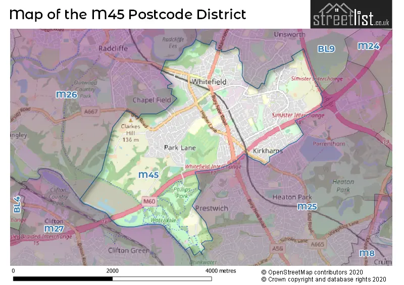
The M45 Postcode shares a border with M25 (Prestwich), BL9 (BURY), M26 (Radcliffe) and M27 (Swinton).
The primary settlement in the M45 postcode district is Whitefield in Greater Manchester. It is the most significant settlement in terms of population. The district also includes the settlements of Manchester and other significant settlements in the Greater Manchester county. The most significant post town in the district is Manchester.
For the district M45, we have data on 4 postcode sectors. Here's a breakdown: The sector M45 0 is non-geographic. It's often designated for PO Boxes, large organisations, or special services. The sector M45 6, covers Whitefield in Greater Manchester. The sector M45 7, covers Whitefield in Greater Manchester. The sector M45 8, covers Whitefield in Greater Manchester.


Map of the M45 Postcode District
Explore the M45 postcode district by using our free interactive map.
When it comes to local government, postal geography often disregards political borders. However, for a breakdown in the M45 District: the district mostly encompasses the Bury District (B) area with a total of 655 postcodes.
Recent House Sales in M45
| Date | Price | Address |
|---|---|---|
| 05/10/2023 | £193,000 | Marston Close, Whitefield, Manchester, M45 8JR |
| 15/09/2023 | £190,000 | Lily Hill Street, Whitefield, Manchester, M45 7SG |
| 15/09/2023 | £540,000 | Ferndale Avenue, Whitefield, Manchester, M45 7GP |
| 12/09/2023 | £425,000 | Carlton Place, Whitefield, Manchester, M45 7JX |
| 08/09/2023 | £277,500 | Park Lane, Whitefield, Manchester, M45 7HL |
| 08/09/2023 | £326,800 | Park Lane, Whitefield, Manchester, M45 7PX |
| 08/09/2023 | £169,000 | Lune Walk, Whitefield, Manchester, M45 8WL |
| 01/09/2023 | £340,000 | Balmoral Avenue, Whitefield, Manchester, M45 6BB |
| 01/09/2023 | £300,000 | Radcliffe New Road, Whitefield, Manchester, M45 7QZ |
| 25/08/2023 | £306,000 | Dartmouth Road, Whitefield, Manchester, M45 6AS |
Weather Forecast for M45
Press Button to Show Forecast for Whitefield
| Time Period | Icon | Description | Temperature | Rain Probability | Wind |
|---|---|---|---|---|---|
| 00:00 to 03:00 | Light rain | 9.0°C (feels like 6.0°C) | 59.00% | WNW 13 mph | |
| 03:00 to 06:00 | Light rain | 8.0°C (feels like 5.0°C) | 47.00% | WNW 11 mph | |
| 06:00 to 09:00 | Cloudy | 8.0°C (feels like 5.0°C) | 8.00% | WNW 11 mph | |
| 09:00 to 12:00 | Cloudy | 9.0°C (feels like 6.0°C) | 8.00% | NW 16 mph | |
| 12:00 to 15:00 | Cloudy | 10.0°C (feels like 7.0°C) | 14.00% | NNW 16 mph | |
| 15:00 to 18:00 | Cloudy | 10.0°C (feels like 8.0°C) | 52.00% | NNW 11 mph | |
| 18:00 to 21:00 | Partly cloudy (day) | 10.0°C (feels like 8.0°C) | 1.00% | N 9 mph | |
| 21:00 to 00:00 | Cloudy | 7.0°C (feels like 5.0°C) | 4.00% | NE 7 mph |
Press Button to Show Forecast for Whitefield
| Time Period | Icon | Description | Temperature | Rain Probability | Wind |
|---|---|---|---|---|---|
| 00:00 to 03:00 | Cloudy | 5.0°C (feels like 3.0°C) | 4.00% | NNE 4 mph | |
| 03:00 to 06:00 | Partly cloudy (night) | 4.0°C (feels like 2.0°C) | 1.00% | N 4 mph | |
| 06:00 to 09:00 | Partly cloudy (day) | 4.0°C (feels like 2.0°C) | 1.00% | N 4 mph | |
| 09:00 to 12:00 | Sunny day | 7.0°C (feels like 6.0°C) | 1.00% | N 4 mph | |
| 12:00 to 15:00 | Cloudy | 10.0°C (feels like 8.0°C) | 5.00% | N 7 mph | |
| 15:00 to 18:00 | Cloudy | 11.0°C (feels like 10.0°C) | 6.00% | NNW 7 mph | |
| 18:00 to 21:00 | Partly cloudy (day) | 10.0°C (feels like 9.0°C) | 1.00% | NNW 7 mph | |
| 21:00 to 00:00 | Partly cloudy (night) | 8.0°C (feels like 6.0°C) | 1.00% | N 4 mph |
Press Button to Show Forecast for Whitefield
| Time Period | Icon | Description | Temperature | Rain Probability | Wind |
|---|---|---|---|---|---|
| 00:00 to 03:00 | Partly cloudy (night) | 6.0°C (feels like 5.0°C) | 2.00% | NNW 2 mph | |
| 03:00 to 06:00 | Cloudy | 6.0°C (feels like 5.0°C) | 5.00% | N 2 mph | |
| 06:00 to 09:00 | Overcast | 6.0°C (feels like 6.0°C) | 8.00% | NNE 2 mph | |
| 09:00 to 12:00 | Cloudy | 9.0°C (feels like 8.0°C) | 7.00% | N 4 mph | |
| 12:00 to 15:00 | Cloudy | 10.0°C (feels like 9.0°C) | 8.00% | NE 7 mph | |
| 15:00 to 18:00 | Cloudy | 11.0°C (feels like 10.0°C) | 7.00% | ENE 7 mph | |
| 18:00 to 21:00 | Cloudy | 11.0°C (feels like 9.0°C) | 6.00% | NE 7 mph | |
| 21:00 to 00:00 | Partly cloudy (night) | 9.0°C (feels like 7.0°C) | 3.00% | NE 7 mph |
Press Button to Show Forecast for Whitefield
| Time Period | Icon | Description | Temperature | Rain Probability | Wind |
|---|---|---|---|---|---|
| 00:00 to 03:00 | Cloudy | 7.0°C (feels like 5.0°C) | 6.00% | ENE 4 mph | |
| 03:00 to 06:00 | Cloudy | 6.0°C (feels like 5.0°C) | 7.00% | E 4 mph | |
| 06:00 to 09:00 | Cloudy | 6.0°C (feels like 5.0°C) | 7.00% | E 4 mph | |
| 09:00 to 12:00 | Cloudy | 8.0°C (feels like 7.0°C) | 7.00% | E 7 mph | |
| 12:00 to 15:00 | Cloudy | 10.0°C (feels like 8.0°C) | 8.00% | ENE 7 mph | |
| 15:00 to 18:00 | Cloudy | 11.0°C (feels like 9.0°C) | 15.00% | ENE 7 mph | |
| 18:00 to 21:00 | Overcast | 10.0°C (feels like 9.0°C) | 10.00% | ENE 7 mph | |
| 21:00 to 00:00 | Partly cloudy (night) | 8.0°C (feels like 7.0°C) | 3.00% | ENE 7 mph |
Where is the M45 Postcode District?
The data shows that the postcode district for M45 is located in MANCHESTER. MANCHESTER is surrounded by several nearby towns, including SALFORD (3.53 miles to the South), BURY (4.08 miles to the North), HEYWOOD (4.28 miles to the North East), BOLTON (6.12 miles to the North West), OLDHAM (8.14 miles to the East), LEIGH (9.63 miles to the West), and DUKINFIELD (10.23 miles to the South East). Additionally, MANCHESTER is approximately 167.88 miles away from the centre of London.
The district is within the post town of MANCHESTER.
The sector has postcodes within the nation of England.
The M45 Postcode District is in the Greater Manchester North East region of Greater Manchester within the North West (England).
| Postcode Sector | Delivery Office |
|---|---|
| M45 6 | Prestwich Delivery Office |
| M45 7 | Prestwich Delivery Office |
| M45 8 | Prestwich Delivery Office |
| M | 4 | 5 | - | X | X | X |
| M | 4 | 5 | Space | Numeric | Letter | Letter |
Current Monthly Rental Prices
| # Bedrooms | Min Price | Max Price | Avg Price |
|---|---|---|---|
| 3 | £1,075 | £1,350 | £1,206 |
Current House Prices
| # Bedrooms | Min Price | Max Price | Avg Price |
|---|---|---|---|
| 1 | £100,000 | £100,000 | £100,000 |
| 2 | £90,000 | £499,950 | £234,767 |
| 3 | £150,000 | £695,000 | £298,248 |
| 4 | £215,000 | £1,475,000 | £569,198 |
| 5 | £365,000 | £1,500,000 | £928,333 |
| 6 | £500,000 | £1,195,000 | £847,500 |
| 7 | £1,750,000 | £1,750,000 | £1,750,000 |
| 9 | £2,400,000 | £2,400,000 | £2,400,000 |
Estate Agents who Operate in the M45 District
| Logo | Name | Brand Name | Address | Contact Number | Total Properties |
|---|---|---|---|---|---|
 | Prestwich | Normie Sales & Lettings | 503-505 Bury New Road, Prestwich, Manchester M25 1AD | 020 3834 7844 | 36 |
 | Prestwich | Clive Anthony Sales & Lettings | 487 Bury New Road, Prestwich, M25 1AD | 0161 524 6870 | 27 |
 | Prestwich | Melissa Berry Sales & Lettings | 455 Bury New Road, Prestwich, Manchester, M25 1AF | 0161 524 0159 | 6 |
 | Prestwich | Aubrey Lee & Co | 39, Bury New Road, Prestwich, Manchester, M25 9JY | 0161 524 4805 | 5 |
 | Whitefield | Jonathan Dines and Co | 228 Bury New Road Whitefield M45 8QN | 0161 524 6070 | 5 |
| Type of Property | 2018 Average | 2018 Sales | 2017 Average | 2017 Sales | 2016 Average | 2016 Sales | 2015 Average | 2015 Sales |
|---|---|---|---|---|---|---|---|---|
| Detached | £460,646 | 60 | £393,268 | 76 | £377,087 | 63 | £367,952 | 65 |
| Semi-Detached | £201,014 | 167 | £178,672 | 155 | £185,934 | 156 | £165,296 | 146 |
| Terraced | £153,820 | 121 | £158,476 | 113 | £141,584 | 140 | £127,444 | 126 |
| Flats | £169,669 | 47 | £201,301 | 47 | £131,901 | 62 | £107,730 | 44 |
Hotels within the Postcode Area
We found 1 hotels and guest houses within the M45 postcode area