The ME2 postcode district is a postal district located in the ME Medway postcode area with a population of 42,823 residents according to the 2021 England and Wales Census.
The area of the ME2 postcode district is 11.83 square miles which is 30.64 square kilometres or 7,570.48 acres.
Currently, the ME2 district has about 939 postcode units spread across 6 geographic postcode sectors.
Given that each sector allows for 400 unique postcode combinations, the district has a capacity of 2,400 postcodes. With 939 postcodes already in use, this leaves 1461 units available.
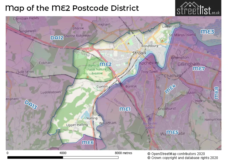
The largest settlement in the ME2 postal code is ROCHESTER followed by Halling, and Strood.
The postcode area has a boundary with Thames Estuary.
The ME2 Postcode shares a border with DA13 (Meopham, Istead Rise, Southfleet), ME6 (SNODLAND), ME1 (ROCHESTER, Wouldham, Burham) and ME3 (Hoo, Higham, Cliffe).
The primary settlement in the ME2 postcode district is Rochester, located in the county of Kent in England. Other significant settlements in the district include Cuxton, Halling, Upper Halling, Strood, Lower Upnor, Medway City Estate, Upnor, and Wainscott. The main post town for the ME2 district is Rochester.
For the district ME2, we have data on 4 postcode sectors. Here's a breakdown: The sector ME2 1, covers Halling and Cuxton and Upper Halling in Kent. The sector ME2 2, covers Rochester in Kent. The sector ME2 3, covers Rochester in Kent. The sector ME2 4, covers Rochester and Medway City Estate and Strood and Wainscott in Kent.


Map of the ME2 Postcode District
Explore the ME2 postcode district by using our free interactive map.
When it comes to local government, postal geography often disregards political borders. However, for a breakdown in the ME2 District: the district mostly encompasses the Medway (B) (931 postcodes), and finally, the Gravesham District (B) area (9 postcodes).
Recent House Sales in ME20
| Date | Price | Address |
|---|---|---|
| 06/10/2023 | £540,000 | Willow Road, Larkfield, Aylesford, ME20 6QZ |
| 08/09/2023 | £438,000 | Fernleigh Rise, Ditton, Aylesford, ME20 6BS |
| 04/09/2023 | £285,000 | Keats Road, Larkfield, Aylesford, ME20 6TR |
| 01/09/2023 | £535,000 | Fielding Drive, Larkfield, Aylesford, ME20 6TY |
| 01/09/2023 | £275,000 | Culpeper Road, Aylesford, ME20 7FJ |
| 01/09/2023 | £318,000 | Brampton Field, Ditton, Aylesford, ME20 6ED |
| 31/08/2023 | £475,000 | Lunsford Lane, Larkfield, Aylesford, ME20 6HW |
| 30/08/2023 | £485,000 | Priory Grove, Ditton, Aylesford, ME20 6BB |
| 30/08/2023 | £525,000 | The Stream, Ditton, Aylesford, ME20 6AG |
| 29/08/2023 | £735,000 | Holt Wood Avenue, Aylesford, ME20 7QH |
Weather Forecast for ME2
Press Button to Show Forecast for Strood
| Time Period | Icon | Description | Temperature | Rain Probability | Wind |
|---|---|---|---|---|---|
| 15:00 to 18:00 | Overcast | 9.0°C (feels like 6.0°C) | 11.00% | N 9 mph | |
| 18:00 to 21:00 | Cloudy | 9.0°C (feels like 6.0°C) | 5.00% | NNW 9 mph | |
| 21:00 to 00:00 | Cloudy | 7.0°C (feels like 4.0°C) | 4.00% | NNW 9 mph |
Press Button to Show Forecast for Strood
| Time Period | Icon | Description | Temperature | Rain Probability | Wind |
|---|---|---|---|---|---|
| 00:00 to 03:00 | Clear night | 5.0°C (feels like 2.0°C) | 0.00% | NW 9 mph | |
| 03:00 to 06:00 | Clear night | 4.0°C (feels like 1.0°C) | 0.00% | NW 9 mph | |
| 06:00 to 09:00 | Partly cloudy (day) | 4.0°C (feels like 1.0°C) | 1.00% | NW 11 mph | |
| 09:00 to 12:00 | Cloudy | 8.0°C (feels like 5.0°C) | 4.00% | NNW 13 mph | |
| 12:00 to 15:00 | Cloudy | 10.0°C (feels like 7.0°C) | 4.00% | NNW 13 mph | |
| 15:00 to 18:00 | Cloudy | 10.0°C (feels like 7.0°C) | 4.00% | NNW 13 mph | |
| 18:00 to 21:00 | Cloudy | 9.0°C (feels like 6.0°C) | 4.00% | N 11 mph | |
| 21:00 to 00:00 | Clear night | 6.0°C (feels like 4.0°C) | 0.00% | NNE 4 mph |
Press Button to Show Forecast for Strood
| Time Period | Icon | Description | Temperature | Rain Probability | Wind |
|---|---|---|---|---|---|
| 00:00 to 03:00 | Cloudy | 4.0°C (feels like 3.0°C) | 4.00% | WSW 4 mph | |
| 03:00 to 06:00 | Cloudy | 4.0°C (feels like 2.0°C) | 4.00% | SW 7 mph | |
| 06:00 to 09:00 | Cloudy | 6.0°C (feels like 3.0°C) | 4.00% | WSW 7 mph | |
| 09:00 to 12:00 | Cloudy | 9.0°C (feels like 6.0°C) | 6.00% | W 9 mph | |
| 12:00 to 15:00 | Overcast | 11.0°C (feels like 9.0°C) | 12.00% | WNW 9 mph | |
| 15:00 to 18:00 | Cloudy | 12.0°C (feels like 10.0°C) | 10.00% | WNW 9 mph | |
| 18:00 to 21:00 | Cloudy | 10.0°C (feels like 9.0°C) | 10.00% | NNW 7 mph | |
| 21:00 to 00:00 | Cloudy | 8.0°C (feels like 6.0°C) | 8.00% | N 7 mph |
Press Button to Show Forecast for Strood
| Time Period | Icon | Description | Temperature | Rain Probability | Wind |
|---|---|---|---|---|---|
| 00:00 to 03:00 | Cloudy | 6.0°C (feels like 5.0°C) | 5.00% | NNE 4 mph | |
| 03:00 to 06:00 | Cloudy | 5.0°C (feels like 3.0°C) | 5.00% | NNE 7 mph | |
| 06:00 to 09:00 | Cloudy | 6.0°C (feels like 4.0°C) | 6.00% | NNE 4 mph | |
| 09:00 to 12:00 | Cloudy | 9.0°C (feels like 7.0°C) | 7.00% | ENE 7 mph | |
| 12:00 to 15:00 | Cloudy | 10.0°C (feels like 8.0°C) | 11.00% | SE 9 mph | |
| 15:00 to 18:00 | Cloudy | 10.0°C (feels like 8.0°C) | 11.00% | SE 9 mph | |
| 18:00 to 21:00 | Cloudy | 10.0°C (feels like 8.0°C) | 12.00% | ESE 9 mph | |
| 21:00 to 00:00 | Cloudy | 8.0°C (feels like 6.0°C) | 11.00% | ESE 7 mph |
Press Button to Show Forecast for Strood
| Time Period | Icon | Description | Temperature | Rain Probability | Wind |
|---|---|---|---|---|---|
| 00:00 to 03:00 | Cloudy | 7.0°C (feels like 5.0°C) | 13.00% | ESE 7 mph | |
| 03:00 to 06:00 | Cloudy | 7.0°C (feels like 5.0°C) | 13.00% | ESE 7 mph | |
| 06:00 to 09:00 | Cloudy | 8.0°C (feels like 6.0°C) | 13.00% | SE 7 mph | |
| 09:00 to 12:00 | Cloudy | 11.0°C (feels like 9.0°C) | 12.00% | SE 9 mph | |
| 12:00 to 15:00 | Light rain shower (day) | 13.0°C (feels like 10.0°C) | 32.00% | SE 11 mph | |
| 15:00 to 18:00 | Light rain shower (day) | 13.0°C (feels like 11.0°C) | 35.00% | SE 11 mph | |
| 18:00 to 21:00 | Cloudy | 12.0°C (feels like 10.0°C) | 13.00% | ESE 11 mph | |
| 21:00 to 00:00 | Cloudy | 11.0°C (feels like 9.0°C) | 13.00% | ESE 9 mph |
Where is the ME2 Postcode District?
The data shows that the postcode district for ME2 is in Rochester, which is located in Kent. Rochester is in close proximity to several nearby towns: - To the east, there is Chatham, which is approximately 3.30 miles away. - To the south, there is Snodland, which is approximately 3.58 miles away. - To the northwest, there is Gravesend, which is approximately 4.89 miles away. - To the west, there is Longfield, which is approximately 6.10 miles away. Additionally, ME2 is around 26.73 miles away from the center of London.
The district is within the post town of ROCHESTER.
The sector has postcodes within the nation of England.
The ME2 Postcode District is covers the following regions.
- Medway - Kent - South East (England)
- Kent Thames Gateway - Kent - South East (England)
| Postcode Sector | Delivery Office |
|---|---|
| ME2 1 | Rochester Delivery Office |
| ME2 2 | Rochester Delivery Office |
| ME2 3 | Rochester Delivery Office |
| ME2 4 | Rochester Delivery Office |
| M | E | 2 | - | X | X | X |
| M | E | 2 | Space | Numeric | Letter | Letter |
Tourist Attractions within the Postcode Area
We found 1 visitor attractions within the ME2 postcode area
| Cobham Wood and Mausoleum |
|---|
| Historic Properties |
| Other Historic Property |
| View Cobham Wood and Mausoleum on Google Maps |
Current Monthly Rental Prices
| # Bedrooms | Min Price | Max Price | Avg Price |
|---|---|---|---|
| £190 | £1,550 | £795 | |
| 1 | £550 | £1,250 | £808 |
| 2 | £1,250 | £1,400 | £1,320 |
| 3 | £1,495 | £1,650 | £1,547 |
| 4 | £2,000 | £2,000 | £2,000 |
Current House Prices
| # Bedrooms | Min Price | Max Price | Avg Price |
|---|---|---|---|
| £90,000 | £90,000 | £90,000 | |
| 1 | £120,000 | £185,000 | £157,500 |
| 2 | £80,000 | £525,000 | £254,058 |
| 3 | £172,000 | £630,000 | £330,178 |
| 4 | £297,000 | £800,000 | £520,767 |
| 5 | £260,000 | £1,350,000 | £646,875 |
Estate Agents who Operate in the ME2 District
| Logo | Name | Brand Name | Address | Contact Number | Total Properties |
|---|---|---|---|---|---|
 | Strood | Wards | 86 High Street, Strood, Rochester, Kent, ME2 4AT | 01634 563335 | 20 |
 | Worthing | Homewise | 1 Liverpool Gardens Worthing BN11 1TF | 01903 497338 | 16 |
 | Strood | Mann | 165 High Street, Strood, Kent, ME2 4TH | 01634 563484 | 13 |
 | Strood | MMS Sales and Lettings | 159 High Street, Strood, Rochester, ME2 4TH | 01634 563317 | 13 |
 | Gravesend | Urban Estates | 20 Windmill Street, Gravesend, DA12 1AS | 01474 554877 | 11 |
| Type of Property | 2018 Average | 2018 Sales | 2017 Average | 2017 Sales | 2016 Average | 2016 Sales | 2015 Average | 2015 Sales |
|---|---|---|---|---|---|---|---|---|
| Detached | £439,802 | 82 | £405,004 | 128 | £394,090 | 137 | £354,670 | 127 |
| Semi-Detached | £304,402 | 241 | £291,938 | 246 | £269,703 | 236 | £238,582 | 245 |
| Terraced | £237,556 | 311 | £230,123 | 337 | £213,264 | 353 | £185,669 | 361 |
| Flats | £198,851 | 78 | £178,312 | 69 | £135,115 | 75 | £131,777 | 72 |