The N17 postcode district is a postal district located in the N London - N postcode area with a population of 68,813 residents according to the 2021 England and Wales Census.
The area of the N17 postcode district is 2.89 square miles which is 7.48 square kilometres or 1,848.67 acres.
Currently, the N17 district has about 1052 postcode units spread across 5 geographic postcode sectors.
Given that each sector allows for 400 unique postcode combinations, the district has a capacity of 2,000 postcodes. With 1052 postcodes already in use, this leaves 948 units available.
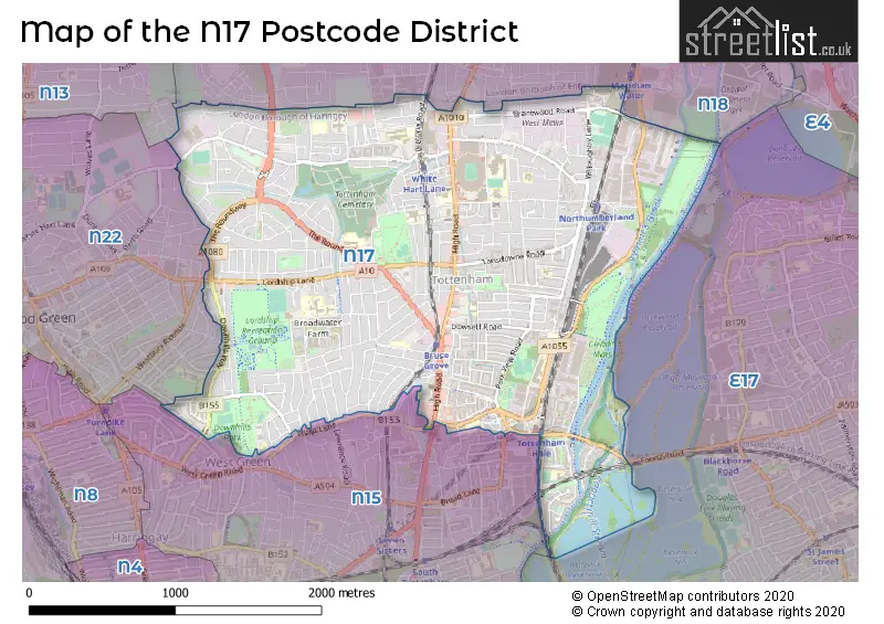
The N17 postal code covers the settlement of TOTTENHAM.
The N17 Postcode shares a border with E17 (WALTHAMSTOW), N15 (TOTTENHAM), N18 (EDMONTON) and N22 (WOOD GREEN).
The primary settlement in the N17 postcode district is Haringey, located in Greater London. Other significant settlements include Enfield and Waltham Forest. The N17 postcode district is part of the post town of London in the county of Greater London.
For the district N17, we have data on 6 postcode sectors. Here's a breakdown: The sector N17 0, covers Haringey in Greater London. The sector N17 1 is non-geographic. It's often designated for PO Boxes, large organisations, or special services. The sector N17 6, covers Haringey in Greater London. The sector N17 7, covers Haringey in Greater London. The sector N17 8, covers Haringey in Greater London. The sector N17 9, covers Haringey in Greater London.

Map of the N17 Postcode District
Explore the N17 postcode district by using our free interactive map.
When it comes to local government, postal geography often disregards political borders. However, for a breakdown in the N17 District: the district mostly encompasses the Haringey London Boro area with a total of 1084 postcodes.
Recent House Sales in N17
| Date | Price | Address |
|---|---|---|
| 19/10/2023 | £385,000 | Steele Road, London, N17 6YJ |
| 13/10/2023 | £565,000 | Seymour Avenue, London, N17 9RE |
| 12/10/2023 | £410,000 | Waterside Way, London, N17 9GD |
| 05/10/2023 | £596,000 | Tower Gardens Road, London, N17 7PX |
| 29/09/2023 | £575,000 | Almond Road, London, N17 0PJ |
| 21/09/2023 | £950,000 | High Road, Tottenham, London, N17 6SB |
| 20/09/2023 | £645,000 | Morrison Avenue, London, N17 6TU |
| 15/09/2023 | £237,000 | Mount Pleasant Road, London, N17 6TQ |
| 14/09/2023 | £420,000 | Belmont Avenue, London, N17 6AX |
| 07/09/2023 | £150,000 | Willoughby Lane, London, N17 0RY |
Weather Forecast for N17
Press Button to Show Forecast for Tottenham Hotspur F.C.
| Time Period | Icon | Description | Temperature | Rain Probability | Wind |
|---|---|---|---|---|---|
| 15:00 to 18:00 | Light rain shower (day) | 11.0°C (feels like 9.0°C) | 49.00% | WNW 9 mph | |
| 18:00 to 21:00 | Cloudy | 9.0°C (feels like 7.0°C) | 47.00% | N 7 mph | |
| 21:00 to 00:00 | Cloudy | 8.0°C (feels like 6.0°C) | 8.00% | ENE 7 mph |
Press Button to Show Forecast for Tottenham Hotspur F.C.
| Time Period | Icon | Description | Temperature | Rain Probability | Wind |
|---|---|---|---|---|---|
| 00:00 to 03:00 | Cloudy | 7.0°C (feels like 5.0°C) | 5.00% | NE 7 mph | |
| 03:00 to 06:00 | Cloudy | 5.0°C (feels like 3.0°C) | 4.00% | NE 7 mph | |
| 06:00 to 09:00 | Cloudy | 5.0°C (feels like 3.0°C) | 4.00% | NE 7 mph | |
| 09:00 to 12:00 | Partly cloudy (day) | 8.0°C (feels like 6.0°C) | 2.00% | ENE 7 mph | |
| 12:00 to 15:00 | Cloudy | 11.0°C (feels like 10.0°C) | 9.00% | E 4 mph | |
| 15:00 to 18:00 | Overcast | 11.0°C (feels like 10.0°C) | 14.00% | ENE 7 mph | |
| 18:00 to 21:00 | Cloudy | 10.0°C (feels like 9.0°C) | 11.00% | E 7 mph | |
| 21:00 to 00:00 | Cloudy | 7.0°C (feels like 5.0°C) | 11.00% | E 7 mph |
Press Button to Show Forecast for Tottenham Hotspur F.C.
| Time Period | Icon | Description | Temperature | Rain Probability | Wind |
|---|---|---|---|---|---|
| 00:00 to 03:00 | Cloudy | 6.0°C (feels like 4.0°C) | 12.00% | ENE 7 mph | |
| 03:00 to 06:00 | Cloudy | 5.0°C (feels like 3.0°C) | 18.00% | NE 7 mph | |
| 06:00 to 09:00 | Cloudy | 6.0°C (feels like 3.0°C) | 19.00% | NE 7 mph | |
| 09:00 to 12:00 | Overcast | 10.0°C (feels like 8.0°C) | 19.00% | ENE 9 mph | |
| 12:00 to 15:00 | Cloudy | 12.0°C (feels like 10.0°C) | 18.00% | E 9 mph | |
| 15:00 to 18:00 | Light rain | 12.0°C (feels like 10.0°C) | 52.00% | E 11 mph | |
| 18:00 to 21:00 | Light rain | 11.0°C (feels like 9.0°C) | 53.00% | ENE 9 mph | |
| 21:00 to 00:00 | Light rain | 10.0°C (feels like 7.0°C) | 49.00% | ENE 11 mph |
Press Button to Show Forecast for Tottenham Hotspur F.C.
| Time Period | Icon | Description | Temperature | Rain Probability | Wind |
|---|---|---|---|---|---|
| 00:00 to 03:00 | Light rain | 9.0°C (feels like 7.0°C) | 52.00% | NE 9 mph | |
| 03:00 to 06:00 | Light rain | 10.0°C (feels like 8.0°C) | 56.00% | ESE 9 mph | |
| 06:00 to 09:00 | Overcast | 10.0°C (feels like 8.0°C) | 51.00% | SE 7 mph | |
| 09:00 to 12:00 | Light rain shower (day) | 11.0°C (feels like 9.0°C) | 45.00% | SE 9 mph | |
| 12:00 to 15:00 | Heavy rain shower (day) | 13.0°C (feels like 11.0°C) | 61.00% | SSW 9 mph | |
| 15:00 to 18:00 | Light rain shower (day) | 14.0°C (feels like 12.0°C) | 43.00% | SW 11 mph | |
| 18:00 to 21:00 | Cloudy | 13.0°C (feels like 10.0°C) | 16.00% | SW 11 mph | |
| 21:00 to 00:00 | Cloudy | 10.0°C (feels like 9.0°C) | 8.00% | SW 7 mph |
Where is the N17 Postcode District?
The postcode district N17 is located in LONDON. It is approximately 6.75 miles away from the center of London. Nearby towns in the vicinity of N17 include Tottenham, Palmers Green, Walthamstow, Wood Green, Edmonton, Leyton, and Chingford.
The district is within the post town of LONDON.
The sector has postcodes within the nation of England.
The N17 Postcode District is covers the following regions.
- Haringey and Islington - Inner London - East - London
- Enfield - Outer London - East and North East - London
- Redbridge and Waltham Forest - Outer London - East and North East - London
| Postcode Sector | Delivery Office |
|---|---|
| N17 0 | Tottenham Sdelivery Office |
| N17 6 | Tottenham Sdelivery Office |
| N17 7 | Tottenham Sdelivery Office |
| N17 8 | Tottenham Sdelivery Office |
| N17 9 | Tottenham Sdelivery Office |
| N | 1 | 7 | - | X | X | X |
| N | 1 | 7 | Space | Numeric | Letter | Letter |
Current Monthly Rental Prices
| # Bedrooms | Min Price | Max Price | Avg Price |
|---|---|---|---|
| £700 | £2,200 | £1,178 | |
| 1 | £750 | £2,600 | £1,916 |
| 2 | £1,650 | £3,200 | £2,409 |
| 3 | £1,733 | £3,715 | £2,751 |
| 4 | £2,800 | £2,800 | £2,800 |
| 6 | £6,156 | £6,156 | £6,156 |
Current House Prices
| # Bedrooms | Min Price | Max Price | Avg Price |
|---|---|---|---|
| £80,125 | £525,000 | £222,874 | |
| 1 | £78,000 | £590,000 | £317,698 |
| 2 | £120,000 | £680,000 | £391,390 |
| 3 | £158,125 | £845,000 | £534,591 |
| 4 | £415,000 | £800,000 | £616,064 |
| 5 | £600,000 | £675,000 | £646,667 |
| 6 | £690,000 | £1,200,000 | £945,000 |
Estate Agents who Operate in the N17 District
| Logo | Name | Brand Name | Address | Contact Number | Total Properties |
|---|---|---|---|---|---|
 | Tottenham | Kings Group | 473 High Road, Tottenham, London N17 6QA | 020 3870 6388 | 23 |
 | The Sessile | Way of Life | 18 Ashley Road, London, N17 9ZS | 020 3535 7579 | 19 |
 | London | OpenRent | 39 Great Windmill Street London W1D 7LX | 020 3322 3265 | 15 |
 | London | Knights Residential | Knights House, 612 High Road, London, N17 9TA | 020 3909 9872 | 15 |
 | Wood Green | Foxtons | 156-158 High Road, London, N22 6EB | 020 3834 8105 | 13 |
| Type of Property | 2018 Average | 2018 Sales | 2017 Average | 2017 Sales | 2016 Average | 2016 Sales | 2015 Average | 2015 Sales |
|---|---|---|---|---|---|---|---|---|
| Detached | £702,500 | 2 | £0 | 0 | £0 | 0 | £850,000 | 1 |
| Semi-Detached | £461,250 | 8 | £534,200 | 10 | £406,000 | 11 | £432,324 | 17 |
| Terraced | £479,680 | 178 | £485,966 | 204 | £448,011 | 216 | £390,789 | 242 |
| Flats | £301,963 | 180 | £304,557 | 187 | £300,597 | 426 | £255,895 | 395 |