The N9 postcode district is a postal district located in the N London - N postcode area with a population of 53,045 residents according to the 2021 England and Wales Census.
The area of the N9 postcode district is 3.25 square miles which is 8.40 square kilometres or 2,076.85 acres.
Currently, the N9 district has about 876 postcode units spread across 4 geographic postcode sectors.
Given that each sector allows for 400 unique postcode combinations, the district has a capacity of 1,600 postcodes. With 876 postcodes already in use, this leaves 724 units available.
The N9 postal code covers the settlement of EDMONTON.
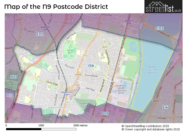
The N9 Postcode shares a border with E4 (CHINGFORD), EN1 (ENFIELD), EN3 (ENFIELD), N13 (SOUTHGATE), N18 (EDMONTON) and N21 (SOUTHGATE).
The primary settlement in the N9 postcode district is Enfield in Greater London. The most significant post town in this district is London, also located in Greater London.
For the district N9, we have data on 5 postcode sectors. Here's a breakdown: The sector N9 0, covers Enfield in Greater London. The sector N9 1 is non-geographic. It's often designated for PO Boxes, large organisations, or special services. The sector N9 7, covers Enfield in Greater London. The sector N9 8, covers Enfield in Greater London. The sector N9 9, covers Enfield in Greater London.


Map of the N9 Postcode District
Explore the N9 postcode district by using our free interactive map.
When it comes to local government, postal geography often disregards political borders. However, for a breakdown in the N9 District: the district mostly encompasses the Enfield London Boro area with a total of 877 postcodes.
Recent House Sales in N9
| Date | Price | Address |
|---|---|---|
| 12/10/2023 | £240,000 | Hudson Way, Edmonton, London, N9 0XG |
| 25/09/2023 | £115,000 | Ainsley Close, Edmonton, London, N9 9XJ |
| 11/09/2023 | £290,000 | Bath Road, London, N9 0JX |
| 08/09/2023 | £375,000 | Lowden Road, London, N9 8RN |
| 29/08/2023 | £360,000 | Hendon Road, London, N9 7AT |
| 25/08/2023 | £490,000 | Woodpecker Close, London, N9 7ND |
| 22/08/2023 | £285,000 | St Edmunds Road, London, N9 7PJ |
| 21/08/2023 | £197,500 | Hickory Close, London, N9 7PY |
| 21/08/2023 | £355,000 | Mayfield Crescent, London, N9 7NH |
| 18/08/2023 | £405,000 | Cambourne Avenue, London, N9 8QG |
Weather Forecast for N9
Press Button to Show Forecast for Tottenham Hotspur F.C.
| Time Period | Icon | Description | Temperature | Rain Probability | Wind |
|---|---|---|---|---|---|
| 09:00 to 12:00 | Cloudy | 9.0°C (feels like 8.0°C) | 7.00% | W 7 mph | |
| 12:00 to 15:00 | Cloudy | 11.0°C (feels like 9.0°C) | 47.00% | W 9 mph | |
| 15:00 to 18:00 | Light rain shower (day) | 11.0°C (feels like 9.0°C) | 49.00% | WNW 9 mph | |
| 18:00 to 21:00 | Cloudy | 9.0°C (feels like 7.0°C) | 47.00% | N 7 mph | |
| 21:00 to 00:00 | Cloudy | 8.0°C (feels like 6.0°C) | 8.00% | ENE 7 mph |
Press Button to Show Forecast for Tottenham Hotspur F.C.
| Time Period | Icon | Description | Temperature | Rain Probability | Wind |
|---|---|---|---|---|---|
| 00:00 to 03:00 | Cloudy | 7.0°C (feels like 5.0°C) | 5.00% | NE 7 mph | |
| 03:00 to 06:00 | Cloudy | 5.0°C (feels like 3.0°C) | 4.00% | NE 7 mph | |
| 06:00 to 09:00 | Cloudy | 5.0°C (feels like 3.0°C) | 4.00% | NE 7 mph | |
| 09:00 to 12:00 | Partly cloudy (day) | 8.0°C (feels like 6.0°C) | 2.00% | ENE 7 mph | |
| 12:00 to 15:00 | Cloudy | 11.0°C (feels like 10.0°C) | 9.00% | E 4 mph | |
| 15:00 to 18:00 | Overcast | 11.0°C (feels like 10.0°C) | 14.00% | ENE 7 mph | |
| 18:00 to 21:00 | Cloudy | 10.0°C (feels like 9.0°C) | 11.00% | E 7 mph | |
| 21:00 to 00:00 | Cloudy | 7.0°C (feels like 5.0°C) | 11.00% | E 7 mph |
Press Button to Show Forecast for Tottenham Hotspur F.C.
| Time Period | Icon | Description | Temperature | Rain Probability | Wind |
|---|---|---|---|---|---|
| 00:00 to 03:00 | Cloudy | 6.0°C (feels like 4.0°C) | 12.00% | ENE 7 mph | |
| 03:00 to 06:00 | Cloudy | 5.0°C (feels like 3.0°C) | 18.00% | NE 7 mph | |
| 06:00 to 09:00 | Cloudy | 6.0°C (feels like 3.0°C) | 19.00% | NE 7 mph | |
| 09:00 to 12:00 | Overcast | 10.0°C (feels like 8.0°C) | 19.00% | ENE 9 mph | |
| 12:00 to 15:00 | Cloudy | 12.0°C (feels like 10.0°C) | 18.00% | E 9 mph | |
| 15:00 to 18:00 | Light rain | 12.0°C (feels like 10.0°C) | 52.00% | E 11 mph | |
| 18:00 to 21:00 | Light rain | 11.0°C (feels like 9.0°C) | 53.00% | ENE 9 mph | |
| 21:00 to 00:00 | Light rain | 10.0°C (feels like 7.0°C) | 49.00% | ENE 11 mph |
Press Button to Show Forecast for Tottenham Hotspur F.C.
| Time Period | Icon | Description | Temperature | Rain Probability | Wind |
|---|---|---|---|---|---|
| 00:00 to 03:00 | Light rain | 9.0°C (feels like 7.0°C) | 52.00% | NE 9 mph | |
| 03:00 to 06:00 | Light rain | 10.0°C (feels like 8.0°C) | 56.00% | ESE 9 mph | |
| 06:00 to 09:00 | Overcast | 10.0°C (feels like 8.0°C) | 51.00% | SE 7 mph | |
| 09:00 to 12:00 | Light rain shower (day) | 11.0°C (feels like 9.0°C) | 45.00% | SE 9 mph | |
| 12:00 to 15:00 | Heavy rain shower (day) | 13.0°C (feels like 11.0°C) | 61.00% | SSW 9 mph | |
| 15:00 to 18:00 | Light rain shower (day) | 14.0°C (feels like 12.0°C) | 43.00% | SW 11 mph | |
| 18:00 to 21:00 | Cloudy | 13.0°C (feels like 10.0°C) | 16.00% | SW 11 mph | |
| 21:00 to 00:00 | Cloudy | 10.0°C (feels like 9.0°C) | 8.00% | SW 7 mph |
Where is the N9 Postcode District?
The postcode district N9 is located in LONDON. It is situated in close proximity to several nearby towns. To the North West is EDMONTON, which is approximately 0.14 miles away. To the East is CHINGFORD, which is around 1.82 miles away. PALMERS GREEN is to the West and is approximately 2.16 miles away. TOTTENHAM is situated in the South West direction, and it is around 2.72 miles away. Finally, WALTHAMSTOW is to the South and is approximately 3.07 miles away. The N9 postcode district is approximately 9.04 miles away from the center of London.
The district is within the post town of LONDON.
The sector has postcodes within the nation of England.
The N9 Postcode District is in the Enfield region of Outer London - East and North East within the London.
You may be interested in our page explaining the evolution of London's Postcodes| Postcode Sector | Delivery Office |
|---|---|
| N9 0 | Lower Edmonton Sdelivery Office |
| N9 7 | Lower Edmonton Sdelivery Office |
| N9 8 | Lower Edmonton Sdelivery Office |
| N9 9 | Lower Edmonton Sdelivery Office |
| N | 9 | - | X | X | X |
| N | 9 | Space | Numeric | Letter | Letter |
Current Monthly Rental Prices
| # Bedrooms | Min Price | Max Price | Avg Price |
|---|---|---|---|
| £1,195 | £1,195 | £1,195 | |
| 1 | £500 | £1,350 | £1,088 |
| 2 | £1,450 | £1,710 | £1,602 |
| 3 | £1,800 | £2,200 | £2,000 |
| 4 | £2,100 | £2,650 | £2,424 |
Current House Prices
| # Bedrooms | Min Price | Max Price | Avg Price |
|---|---|---|---|
| £175,000 | £179,995 | £178,330 | |
| 1 | £115,000 | £260,000 | £215,377 |
| 2 | £145,000 | £535,000 | £346,221 |
| 3 | £330,000 | £750,000 | £487,514 |
| 4 | £450,000 | £863,750 | £538,375 |
| 5 | £625,000 | £625,000 | £625,000 |
Estate Agents who Operate in the N9 District
| Logo | Name | Brand Name | Address | Contact Number | Total Properties |
|---|---|---|---|---|---|
 | Edmonton | Knights Residential | 1 Keats Parade, Church Street, London, N9 9DP | 020 3834 7954 | 17 |
 | Edmonton | Kings Group | 6 Church Street London N9 9DX | 020 3835 4075 | 16 |
 | Edmonton - Sales | Castles Estate Agents | 438 Hertford Road, London, N9 8AB | 020 3840 3311 | 11 |
 | Edmonton | Bairstow Eves | 9 - 10 Angel Corner Parade, Fore Street, Edmonton, London, N18 2QH | 020 3871 0501 | 10 |
 | Edmonton | Target Property | 315 Hertford Road, London, N9 7ET | 020 3834 8147 | 4 |
| Type of Property | 2018 Average | 2018 Sales | 2017 Average | 2017 Sales | 2016 Average | 2016 Sales | 2015 Average | 2015 Sales |
|---|---|---|---|---|---|---|---|---|
| Detached | £585,000 | 2 | £422,180 | 5 | £362,500 | 2 | £485,100 | 5 |
| Semi-Detached | £402,967 | 45 | £428,261 | 46 | £373,232 | 41 | £352,759 | 56 |
| Terraced | £367,342 | 213 | £363,924 | 222 | £354,904 | 233 | £307,007 | 319 |
| Flats | £230,799 | 137 | £221,518 | 140 | £211,499 | 145 | £188,018 | 210 |