The NE22 postcode district is a postal district located in the NE Newcastle upon Tyne postcode area with a population of 17,946 residents according to the 2021 England and Wales Census.
The area of the NE22 postcode district is 8.76 square miles which is 22.68 square kilometres or 5,605.57 acres.
Currently, the NE22 district has about 512 postcode units spread across 3 geographic postcode sectors.
Given that each sector allows for 400 unique postcode combinations, the district has a capacity of 1,200 postcodes. With 512 postcodes already in use, this leaves 688 units available.
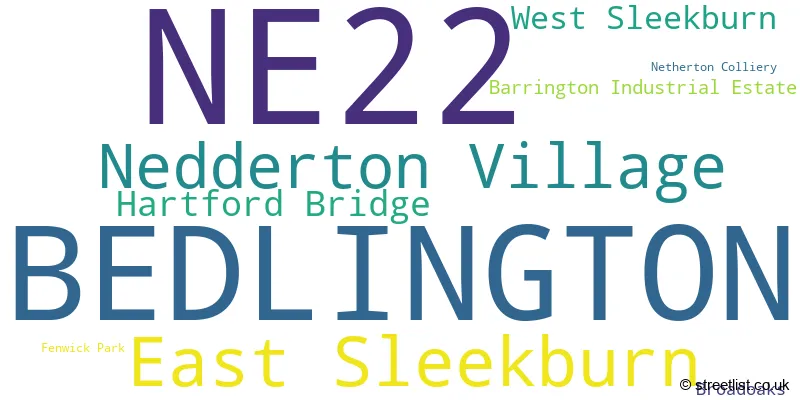
The largest settlement in the NE22 postal code is BEDLINGTON followed by East Sleekburn, and Fenwick Park.
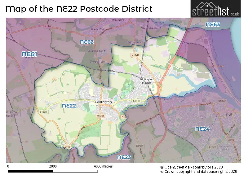
The postcode area has a boundary with The North Sea.
The NE22 Postcode shares a border with NE24 (BLYTH, Cambois, Blyth Riverside Business Park), NE61 (MORPETH, Pegswood, Widdrington), NE62 (CHOPPINGTON, Scotland Gate, West Sleekburn), NE63 (ASHINGTON, North Seaton) and NE23 (CRAMLINGTON, Dudley, Seghill).
The primary settlement in the NE22 postcode district is Bedlington, which is located in the county of Northumberland in England. Other significant settlements in the district include Broadoaks, Fenwick Park, Hartford Bridge, Nedderton Village, and Netherton Colliery. The most significant post town in the district is Bedlington.
For the district NE22, we have data on 3 postcode sectors. Here's a breakdown: The sector NE22 5, covers Bedlington in Northumberland. The sector NE22 6, covers Bedlington in Northumberland. The sector NE22 7, covers Bedlington and East Sleekburn in Northumberland.

Map of the NE22 Postcode District
Explore the NE22 postcode district by using our free interactive map.
When it comes to local government, postal geography often disregards political borders. However, for a breakdown in the NE22 District: the district mostly encompasses the Northumberland area with a total of 519 postcodes.
Recent House Sales in NE22
| Date | Price | Address |
|---|---|---|
| 24/10/2023 | £238,000 | Augustus Drive, Bedlington, NE22 6LF |
| 16/10/2023 | £180,000 | Hollymount Square, Bedlington, NE22 5AH |
| 13/10/2023 | £30,000 | Rothesay Terrace, Bedlington, NE22 5PS |
| 10/10/2023 | £327,500 | Errington Way, Fenwick Park, Bedlington, NE22 6FH |
| 10/10/2023 | £65,400 | Brook Court, Bedlington, NE22 5DF |
| 06/10/2023 | £250,000 | Newby Close, Bedlington, NE22 5YT |
| 18/09/2023 | £39,995 | North Ridge, Bedlington, NE22 6EU |
| 04/09/2023 | £135,000 | Barrington Court, Bedlington, NE22 5DH |
| 01/09/2023 | £60,000 | Rosalind Avenue, Bedlington, NE22 5BA |
| 01/09/2023 | £85,000 | Balmoral Close, Bedlington, NE22 5YD |
Weather Forecast for NE22
Press Button to Show Forecast for Bedlington
| Time Period | Icon | Description | Temperature | Rain Probability | Wind |
|---|---|---|---|---|---|
| 03:00 to 06:00 | Overcast | 4.0°C (feels like 0.0°C) | 17.00% | NW 9 mph | |
| 06:00 to 09:00 | Cloudy | 4.0°C (feels like 0.0°C) | 5.00% | NNW 11 mph | |
| 09:00 to 12:00 | Cloudy | 6.0°C (feels like 2.0°C) | 8.00% | N 16 mph | |
| 12:00 to 15:00 | Cloudy | 7.0°C (feels like 4.0°C) | 7.00% | N 16 mph | |
| 15:00 to 18:00 | Partly cloudy (day) | 8.0°C (feels like 5.0°C) | 1.00% | NNE 13 mph | |
| 18:00 to 21:00 | Cloudy | 7.0°C (feels like 4.0°C) | 4.00% | ENE 7 mph | |
| 21:00 to 00:00 | Cloudy | 6.0°C (feels like 3.0°C) | 5.00% | SW 7 mph |
Press Button to Show Forecast for Bedlington
| Time Period | Icon | Description | Temperature | Rain Probability | Wind |
|---|---|---|---|---|---|
| 00:00 to 03:00 | Cloudy | 5.0°C (feels like 2.0°C) | 6.00% | W 9 mph | |
| 03:00 to 06:00 | Cloudy | 5.0°C (feels like 1.0°C) | 7.00% | WNW 9 mph | |
| 06:00 to 09:00 | Cloudy | 5.0°C (feels like 1.0°C) | 7.00% | NW 11 mph | |
| 09:00 to 12:00 | Cloudy | 6.0°C (feels like 2.0°C) | 31.00% | NNW 13 mph | |
| 12:00 to 15:00 | Cloudy | 7.0°C (feels like 4.0°C) | 6.00% | N 13 mph | |
| 15:00 to 18:00 | Partly cloudy (day) | 7.0°C (feels like 4.0°C) | 2.00% | NNE 11 mph | |
| 18:00 to 21:00 | Sunny day | 6.0°C (feels like 4.0°C) | 2.00% | NNE 9 mph | |
| 21:00 to 00:00 | Clear night | 4.0°C (feels like 2.0°C) | 1.00% | NE 4 mph |
Press Button to Show Forecast for Bedlington
| Time Period | Icon | Description | Temperature | Rain Probability | Wind |
|---|---|---|---|---|---|
| 00:00 to 03:00 | Cloudy | 3.0°C (feels like 1.0°C) | 4.00% | NNE 4 mph | |
| 03:00 to 06:00 | Cloudy | 3.0°C (feels like 1.0°C) | 4.00% | NNW 4 mph | |
| 06:00 to 09:00 | Cloudy | 4.0°C (feels like 2.0°C) | 5.00% | NNW 4 mph | |
| 09:00 to 12:00 | Cloudy | 7.0°C (feels like 4.0°C) | 7.00% | ENE 7 mph | |
| 12:00 to 15:00 | Cloudy | 7.0°C (feels like 5.0°C) | 8.00% | E 9 mph | |
| 15:00 to 18:00 | Cloudy | 8.0°C (feels like 5.0°C) | 7.00% | E 9 mph | |
| 18:00 to 21:00 | Cloudy | 7.0°C (feels like 4.0°C) | 7.00% | E 9 mph | |
| 21:00 to 00:00 | Cloudy | 5.0°C (feels like 3.0°C) | 8.00% | ESE 9 mph |
Press Button to Show Forecast for Bedlington
| Time Period | Icon | Description | Temperature | Rain Probability | Wind |
|---|---|---|---|---|---|
| 00:00 to 03:00 | Overcast | 5.0°C (feels like 3.0°C) | 24.00% | ESE 7 mph | |
| 03:00 to 06:00 | Cloudy | 5.0°C (feels like 2.0°C) | 8.00% | ESE 7 mph | |
| 06:00 to 09:00 | Cloudy | 6.0°C (feels like 3.0°C) | 9.00% | ESE 9 mph | |
| 09:00 to 12:00 | Overcast | 7.0°C (feels like 4.0°C) | 14.00% | ESE 11 mph | |
| 12:00 to 15:00 | Cloudy | 8.0°C (feels like 5.0°C) | 13.00% | E 13 mph | |
| 15:00 to 18:00 | Cloudy | 8.0°C (feels like 5.0°C) | 12.00% | E 13 mph | |
| 18:00 to 21:00 | Cloudy | 7.0°C (feels like 4.0°C) | 11.00% | E 13 mph | |
| 21:00 to 00:00 | Partly cloudy (night) | 7.0°C (feels like 4.0°C) | 9.00% | ENE 11 mph |
Where is the NE22 Postcode District?
The postcode district NE22 is located in the town of Bedlington. It is surrounded by several nearby towns, including Choppington to the north, Blyth to the southeast, Cramlington to the south, Newbiggin-by-the-Sea to the northeast, and Morpeth to the northwest. Additionally, NE22 is approximately 258.08 miles away from the center of London.
The district is within the post town of BEDLINGTON.
The sector has postcodes within the nation of England.
The NE22 Postcode District is in the Northumberland region of Northumberland and Tyne and Wear within the North East (England).
| Postcode Sector | Delivery Office |
|---|---|
| NE22 5 | Ashington Delivery Office |
| NE22 6 | Ashington Delivery Office |
| NE22 7 | Ashington Delivery Office |
| N | E | 2 | 2 | - | X | X | X |
| N | E | 2 | 2 | Space | Numeric | Letter | Letter |
Tourist Attractions within the Postcode Area
We found 1 visitor attractions within the NE22 postcode area
| Bedlington Country Park Local Nature Reserve |
|---|
| Country Parks |
| Country Park |
| View Bedlington Country Park Local Nature Reserve on Google Maps |
Current Monthly Rental Prices
| # Bedrooms | Min Price | Max Price | Avg Price |
|---|---|---|---|
| 2 | £495 | £1,150 | £740 |
| 3 | £640 | £695 | £668 |
Current House Prices
| # Bedrooms | Min Price | Max Price | Avg Price |
|---|---|---|---|
| £50,000 | £550,000 | £300,000 | |
| 1 | £40,000 | £40,000 | £40,000 |
| 2 | £15,000 | £375,000 | £133,404 |
| 3 | £80,000 | £395,000 | £172,994 |
| 4 | £225,000 | £3,800,000 | £480,852 |
| 5 | £299,950 | £389,950 | £354,963 |
| 6 | £740,000 | £740,000 | £740,000 |
Estate Agents who Operate in the NE22 District
| Logo | Name | Brand Name | Address | Contact Number | Total Properties |
|---|---|---|---|---|---|
 | Bedlington | Rook Matthews Sayer | 82 Front Street West, Bedlington, NE22 5UA | 01670 332692 | 10 |
 | Bedlington | Pattinson Estate Agents | 17-18 Market Place, Bedlington, NE22 5TN | 0191 625 1039 | 10 |
 | Bedlington | Mike Rogerson Estate Agents | 66 Front Street West, Bedlington, NE22 5UA | 01670 332468 | 7 |
 | Whitley Bay | Signature | Head Office, 32 Beach Avenue, Tyne and Wear, NE26 1EA | 0191 625 1042 | 6 |
 | Blyth | Lennon Properties | 9 Regent Street Blyth NE24 1LQ | 01670 332649 | 4 |
| Type of Property | 2018 Average | 2018 Sales | 2017 Average | 2017 Sales | 2016 Average | 2016 Sales | 2015 Average | 2015 Sales |
|---|---|---|---|---|---|---|---|---|
| Detached | £238,879 | 89 | £224,881 | 92 | £217,804 | 110 | £215,199 | 91 |
| Semi-Detached | £119,742 | 84 | £115,792 | 80 | £106,211 | 94 | £116,868 | 82 |
| Terraced | £88,351 | 90 | £88,445 | 87 | £105,728 | 88 | £107,824 | 64 |
| Flats | £58,526 | 29 | £66,286 | 69 | £70,762 | 29 | £72,085 | 32 |