The NG8 postcode district is a postal district located in the NG Nottingham postcode area with a population of 67,062 residents according to the 2021 England and Wales Census.
The area of the NG8 postcode district is 7.78 square miles which is 20.15 square kilometres or 4,979.41 acres.
Currently, the NG8 district has about 1198 postcode units spread across 6 geographic postcode sectors.
Given that each sector allows for 400 unique postcode combinations, the district has a capacity of 2,400 postcodes. With 1198 postcodes already in use, this leaves 1202 units available.
The largest settlements in the NG8 postal code are NOTTINGHAM and Strelley.
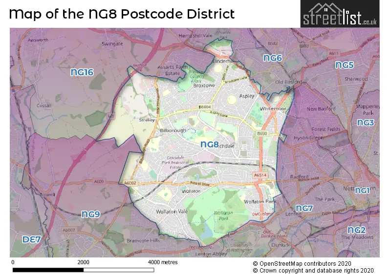
The NG8 Postcode shares a border with NG16 (Eastwood, Selston, Langley Mill), NG9 (Beeston, Stapleford, Bramcote), NG6 (NOTTINGHAM, Bestwood Village, Bulwell) and NG7 (NOTTINGHAM, Lenton, New Basford).
The primary settlement in the NG8 postcode district is Nottingham, located in the county of Nottinghamshire, England. Other significant settlements include Wollaton and Strelley. The post town associated with this postcode district is Nottingham.
For the district NG8, we have data on 7 postcode sectors. Here's a breakdown: The sector NG8 1, covers Nottingham in Nottinghamshire. The sector NG8 2, covers Nottingham in Nottinghamshire. The sector NG8 3, covers Nottingham in Nottinghamshire. The sector NG8 4, covers Nottingham in Nottinghamshire. The sector NG8 5, covers Nottingham in Nottinghamshire. The sector NG8 6, covers Nottingham in Nottinghamshire. The sector NG8 9 is non-geographic. It's often designated for PO Boxes, large organisations, or special services.

Map of the NG8 Postcode District
Explore the NG8 postcode district by using our free interactive map.
When it comes to local government, postal geography often disregards political borders. However, for a breakdown in the NG8 District: the district mostly encompasses the City of Nottingham (B) (1183 postcodes), and finally, the Broxtowe District (B) area (19 postcodes).
Recent House Sales in NG8
| Date | Price | Address |
|---|---|---|
| 09/10/2023 | £82,954 | White Lodge Gardens, Nottingham, NG8 4BL |
| 06/10/2023 | £178,000 | Flamsteed Road, Nottingham, NG8 6LR |
| 06/10/2023 | £220,000 | Harby Drive, Nottingham, NG8 1AR |
| 02/10/2023 | £102,000 | Cyril Avenue, Nottingham, NG8 5BA |
| 29/09/2023 | £136,000 | Denewood Crescent, Nottingham, NG8 3DA |
| 27/09/2023 | £110,150 | Beckley Road, Broxtowe, Nottingham, NG8 6GW |
| 27/09/2023 | £118,000 | Jasmine Close, Strelley, Nottingham, NG8 6GG |
| 21/09/2023 | £140,000 | Chesil Avenue, Nottingham, NG8 1QA |
| 15/09/2023 | £120,000 | Lavender Close, Nottingham, NG8 6FZ |
| 14/09/2023 | £459,000 | Seaford Avenue, Nottingham, NG8 1LA |
Weather Forecast for NG8
Press Button to Show Forecast for Bilborough
| Time Period | Icon | Description | Temperature | Rain Probability | Wind |
|---|---|---|---|---|---|
| 15:00 to 18:00 | Cloudy | 8.0°C (feels like 7.0°C) | 7.00% | NNE 4 mph | |
| 18:00 to 21:00 | Cloudy | 8.0°C (feels like 6.0°C) | 6.00% | NE 7 mph | |
| 21:00 to 00:00 | Cloudy | 5.0°C (feels like 3.0°C) | 5.00% | E 7 mph |
Press Button to Show Forecast for Bilborough
| Time Period | Icon | Description | Temperature | Rain Probability | Wind |
|---|---|---|---|---|---|
| 00:00 to 03:00 | Partly cloudy (night) | 4.0°C (feels like 2.0°C) | 1.00% | ENE 4 mph | |
| 03:00 to 06:00 | Partly cloudy (night) | 2.0°C (feels like 1.0°C) | 1.00% | NNE 4 mph | |
| 06:00 to 09:00 | Sunny day | 3.0°C (feels like 0.0°C) | 1.00% | NNE 4 mph | |
| 09:00 to 12:00 | Partly cloudy (day) | 7.0°C (feels like 5.0°C) | 2.00% | ENE 7 mph | |
| 12:00 to 15:00 | Cloudy | 9.0°C (feels like 8.0°C) | 8.00% | ENE 4 mph | |
| 15:00 to 18:00 | Cloudy | 9.0°C (feels like 8.0°C) | 8.00% | ENE 4 mph | |
| 18:00 to 21:00 | Cloudy | 8.0°C (feels like 6.0°C) | 11.00% | ENE 9 mph | |
| 21:00 to 00:00 | Cloudy | 6.0°C (feels like 3.0°C) | 10.00% | ENE 7 mph |
Press Button to Show Forecast for Bilborough
| Time Period | Icon | Description | Temperature | Rain Probability | Wind |
|---|---|---|---|---|---|
| 00:00 to 03:00 | Partly cloudy (night) | 4.0°C (feels like 2.0°C) | 8.00% | NE 4 mph | |
| 03:00 to 06:00 | Cloudy | 4.0°C (feels like 1.0°C) | 11.00% | NE 7 mph | |
| 06:00 to 09:00 | Cloudy | 4.0°C (feels like 1.0°C) | 10.00% | NE 7 mph | |
| 09:00 to 12:00 | Cloudy | 8.0°C (feels like 5.0°C) | 12.00% | ENE 9 mph | |
| 12:00 to 15:00 | Cloudy | 9.0°C (feels like 7.0°C) | 18.00% | ENE 9 mph | |
| 15:00 to 18:00 | Overcast | 10.0°C (feels like 8.0°C) | 21.00% | ENE 11 mph | |
| 18:00 to 21:00 | Cloudy | 9.0°C (feels like 7.0°C) | 19.00% | ENE 11 mph | |
| 21:00 to 00:00 | Cloudy | 7.0°C (feels like 4.0°C) | 15.00% | NE 11 mph |
Press Button to Show Forecast for Bilborough
| Time Period | Icon | Description | Temperature | Rain Probability | Wind |
|---|---|---|---|---|---|
| 00:00 to 03:00 | Overcast | 7.0°C (feels like 4.0°C) | 22.00% | NE 11 mph | |
| 03:00 to 06:00 | Light rain | 7.0°C (feels like 3.0°C) | 52.00% | NNE 13 mph | |
| 06:00 to 09:00 | Heavy rain | 7.0°C (feels like 4.0°C) | 77.00% | NNE 13 mph | |
| 09:00 to 12:00 | Heavy rain | 8.0°C (feels like 5.0°C) | 78.00% | NE 13 mph | |
| 12:00 to 15:00 | Heavy rain | 10.0°C (feels like 7.0°C) | 77.00% | N 13 mph | |
| 15:00 to 18:00 | Light rain shower (day) | 10.0°C (feels like 7.0°C) | 42.00% | N 11 mph | |
| 18:00 to 21:00 | Light rain shower (day) | 10.0°C (feels like 8.0°C) | 39.00% | NNE 9 mph | |
| 21:00 to 00:00 | Cloudy | 8.0°C (feels like 6.0°C) | 11.00% | SW 7 mph |
Where is the NG8 Postcode District?
The postcode district NG8 is located in Nottingham. It is nearby towns such as Ilkeston, Heanor, Sutton-in-Ashfield, and Southwell. The distance from NG8 to London is approximately 110.8 miles.
The district is within the post town of NOTTINGHAM.
The sector has postcodes within the nation of England.
The NG8 Postcode District is covers the following regions.
- Nottingham - Derbyshire and Nottinghamshire - East Midlands (England)
- South Nottinghamshire - Derbyshire and Nottinghamshire - East Midlands (England)
| Postcode Sector | Delivery Office |
|---|---|
| NG8 1 | Glaisdale Parkway Delivery Office |
| NG8 2 | Glaisdale Parkway Delivery Office |
| NG8 3 | Glaisdale Parkway Delivery Office |
| NG8 4 | Glaisdale Parkway Delivery Office |
| NG8 5 | Glaisdale Parkway Delivery Office |
| NG8 6 | Glaisdale Parkway Delivery Office |
| N | G | 8 | - | X | X | X |
| N | G | 8 | Space | Numeric | Letter | Letter |
Tourist Attractions within the Postcode Area
We found 1 visitor attractions within the NG8 postcode area
| Wollaton Hall and Park |
|---|
| Museums & Art Galleries |
| Museum and / or Art Gallery |
| View Wollaton Hall and Park on Google Maps |
Current Monthly Rental Prices
| # Bedrooms | Min Price | Max Price | Avg Price |
|---|---|---|---|
| 1 | £565 | £750 | £611 |
| 2 | £825 | £1,352 | £1,013 |
| 3 | £895 | £2,200 | £1,281 |
| 4 | £1,200 | £3,100 | £1,731 |
| 5 | £1,993 | £2,383 | £2,235 |
| 6 | £2,600 | £2,730 | £2,683 |
Current House Prices
| # Bedrooms | Min Price | Max Price | Avg Price |
|---|---|---|---|
| £155,000 | £240,000 | £197,500 | |
| 1 | £265,000 | £265,000 | £265,000 |
| 2 | £65,000 | £475,000 | £214,130 |
| 3 | £140,000 | £700,000 | £291,015 |
| 4 | £220,000 | £1,200,000 | £457,839 |
| 5 | £315,000 | £800,000 | £555,381 |
| 6 | £450,000 | £1,350,000 | £951,188 |
| 8 | £750,000 | £750,000 | £750,000 |
Estate Agents who Operate in the NG8 District
| Logo | Name | Brand Name | Address | Contact Number | Total Properties |
|---|---|---|---|---|---|
 | Wollaton | Bairstow Eves | 205A Bramcote Lane, Nottingham, Nottinghamshire, NG8 2QJ | 0115 647 0982 | 48 |
 | Nottingham | William H. Brown | 20 Upper Parliament Street Nottingham NG1 2AG | 0115 647 4013 | 24 |
 | Wollaton | YOUR MOVE SDS | 158a Bramcote Lane, Wollaton, Nottingham, NG8 2QP | 0115 647 2689 | 23 |
 | Hucknall | HoldenCopley | 33A High Street, Hucknall, Nottingham, NG15 7HJ | 0115 647 9661 | 17 |
 | Beeston | Robert Ellis | 12 High Road Beeston Nottingham NG9 2JP | 0115 647 2080 | 17 |
| Type of Property | 2018 Average | 2018 Sales | 2017 Average | 2017 Sales | 2016 Average | 2016 Sales | 2015 Average | 2015 Sales |
|---|---|---|---|---|---|---|---|---|
| Detached | £284,943 | 317 | £278,920 | 319 | £267,616 | 270 | £257,667 | 272 |
| Semi-Detached | £161,686 | 312 | £152,734 | 345 | £143,929 | 351 | £130,461 | 336 |
| Terraced | £120,645 | 212 | £108,270 | 239 | £104,140 | 192 | £85,529 | 198 |
| Flats | £93,256 | 39 | £96,649 | 32 | £80,376 | 21 | £72,688 | 24 |