The NN29 postcode district is a postal district located in the NN Northampton postcode area with a population of 11,812 residents according to the 2021 England and Wales Census.
The area of the NN29 postcode district is 24.49 square miles which is 63.44 square kilometres or 15,676.42 acres.
Currently, the NN29 district has about 274 postcode units spread across 1 geographic postcode sectors.
Given that each sector allows for 400 unique postcode combinations, the district has a capacity of 400 postcodes. With 274 postcodes already in use, this leaves 126 units available.
The largest settlement in the NN29 postal code is Irchester followed by Wollaston, and Bozeat.
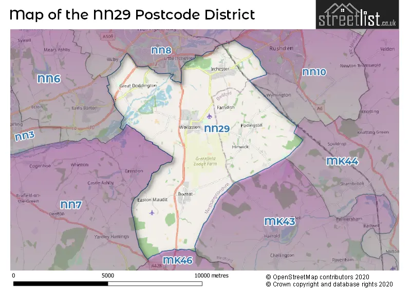
The NN29 Postcode shares a border with MK43 (Cranfield, Wootton, Marston Moretaine), MK46 (OLNEY, Lavendon, Emberton), NN10 (RUSHDEN, Higham Ferrers, Wymington), NN6 (Earls Barton, Brixworth, Long Buckby), NN7 (Weedon, Roade, Bugbrooke) and NN8 (WELLINGBOROUGH, Finedon Road Industrial Estate, Wilby).
The primary settlement in the NN29 postcode district is Wollaston, located in the county of Northamptonshire in the East Midlands region of England. Other significant settlements in the district include Irchester, Great Doddington, and Knuston, also located in Northamptonshire. The post town for this district is Wellingborough.
For the district NN29, we have data on 1 postcode sectors. Here's a breakdown: The sector NN29 7, covers Wollaston and Irchester and Bozeat in Northamptonshire.
NN29 Postcode Sectors


Map of the NN29 Postcode District
Explore the NN29 postcode district by using our free interactive map.
When it comes to local government, postal geography often disregards political borders. However, for a breakdown in the NN29 District: the district mostly encompasses the North Northamptonshire (265 postcodes), and finally, the Bedford (B) area (14 postcodes).
Recent House Sales in NN29
| Date | Price | Address |
|---|---|---|
| 17/10/2023 | £315,000 | Roberts Street, Bozeat, Wellingborough, NN29 7JZ |
| 13/10/2023 | £396,995 | Briarwood Way, Wollaston, Wellingborough, NN29 7QR |
| 29/09/2023 | £255,000 | Howard Road, Wollaston, Wellingborough, NN29 7QZ |
| 19/09/2023 | £295,000 | John Gray Road, Great Doddington, Wellingborough, NN29 7TF |
| 25/08/2023 | £210,000 | Arkwright Road, Irchester, Wellingborough, NN29 7HD |
| 25/08/2023 | £280,500 | Mansfield Way, Irchester, Wellingborough, NN29 7DQ |
| 24/08/2023 | £320,000 | Allens Hill, Bozeat, Wellingborough, NN29 7LW |
| 18/08/2023 | £315,000 | Duck End, Wollaston, Wellingborough, NN29 7SH |
| 04/08/2023 | £235,000 | London Road, Wollaston, Wellingborough, NN29 7QP |
| 03/08/2023 | £236,000 | Mill Road, Bozeat, Wellingborough, NN29 7JA |
Weather Forecast for NN29
Press Button to Show Forecast for Santa Pod Raceway
| Time Period | Icon | Description | Temperature | Rain Probability | Wind |
|---|---|---|---|---|---|
| 00:00 to 03:00 | Clear night | 3.0°C (feels like 0.0°C) | 0.00% | NNW 7 mph | |
| 03:00 to 06:00 | Clear night | 3.0°C (feels like -1.0°C) | 0.00% | NNW 7 mph | |
| 06:00 to 09:00 | Partly cloudy (day) | 3.0°C (feels like 0.0°C) | 1.00% | NNW 9 mph | |
| 09:00 to 12:00 | Cloudy | 7.0°C (feels like 4.0°C) | 4.00% | N 13 mph | |
| 12:00 to 15:00 | Cloudy | 9.0°C (feels like 6.0°C) | 4.00% | N 13 mph | |
| 15:00 to 18:00 | Cloudy | 10.0°C (feels like 7.0°C) | 5.00% | N 11 mph | |
| 18:00 to 21:00 | Cloudy | 9.0°C (feels like 7.0°C) | 5.00% | NNE 9 mph | |
| 21:00 to 00:00 | Cloudy | 5.0°C (feels like 4.0°C) | 8.00% | NE 4 mph |
Press Button to Show Forecast for Santa Pod Raceway
| Time Period | Icon | Description | Temperature | Rain Probability | Wind |
|---|---|---|---|---|---|
| 00:00 to 03:00 | Cloudy | 5.0°C (feels like 3.0°C) | 9.00% | N 4 mph | |
| 03:00 to 06:00 | Overcast | 5.0°C (feels like 2.0°C) | 8.00% | NNW 7 mph | |
| 06:00 to 09:00 | Overcast | 5.0°C (feels like 2.0°C) | 8.00% | N 7 mph | |
| 09:00 to 12:00 | Overcast | 7.0°C (feels like 4.0°C) | 10.00% | NNE 9 mph | |
| 12:00 to 15:00 | Overcast | 9.0°C (feels like 6.0°C) | 10.00% | NNE 11 mph | |
| 15:00 to 18:00 | Overcast | 9.0°C (feels like 7.0°C) | 10.00% | NNE 11 mph | |
| 18:00 to 21:00 | Partly cloudy (day) | 8.0°C (feels like 5.0°C) | 2.00% | NE 9 mph | |
| 21:00 to 00:00 | Clear night | 5.0°C (feels like 2.0°C) | 2.00% | NE 7 mph |
Press Button to Show Forecast for Santa Pod Raceway
| Time Period | Icon | Description | Temperature | Rain Probability | Wind |
|---|---|---|---|---|---|
| 00:00 to 03:00 | Partly cloudy (night) | 3.0°C (feels like 1.0°C) | 3.00% | NNE 4 mph | |
| 03:00 to 06:00 | Cloudy | 3.0°C (feels like 1.0°C) | 5.00% | N 4 mph | |
| 06:00 to 09:00 | Cloudy | 4.0°C (feels like 2.0°C) | 9.00% | NNW 4 mph | |
| 09:00 to 12:00 | Cloudy | 7.0°C (feels like 5.0°C) | 11.00% | NNW 7 mph | |
| 12:00 to 15:00 | Light rain | 8.0°C (feels like 6.0°C) | 50.00% | N 7 mph | |
| 15:00 to 18:00 | Light rain | 8.0°C (feels like 6.0°C) | 50.00% | NNW 7 mph | |
| 18:00 to 21:00 | Cloudy | 7.0°C (feels like 5.0°C) | 20.00% | NNW 7 mph | |
| 21:00 to 00:00 | Cloudy | 6.0°C (feels like 4.0°C) | 18.00% | NNW 4 mph |
Press Button to Show Forecast for Santa Pod Raceway
| Time Period | Icon | Description | Temperature | Rain Probability | Wind |
|---|---|---|---|---|---|
| 00:00 to 03:00 | Cloudy | 5.0°C (feels like 3.0°C) | 10.00% | NNE 7 mph | |
| 03:00 to 06:00 | Cloudy | 5.0°C (feels like 3.0°C) | 15.00% | NNE 7 mph | |
| 06:00 to 09:00 | Cloudy | 5.0°C (feels like 3.0°C) | 10.00% | N 7 mph | |
| 09:00 to 12:00 | Overcast | 8.0°C (feels like 6.0°C) | 9.00% | N 9 mph | |
| 12:00 to 15:00 | Overcast | 10.0°C (feels like 8.0°C) | 11.00% | NNE 9 mph | |
| 15:00 to 18:00 | Cloudy | 11.0°C (feels like 8.0°C) | 23.00% | NNE 9 mph | |
| 18:00 to 21:00 | Cloudy | 9.0°C (feels like 7.0°C) | 7.00% | NNE 9 mph | |
| 21:00 to 00:00 | Clear night | 6.0°C (feels like 4.0°C) | 2.00% | NNE 7 mph |
Where is the NN29 Postcode District?
The NN29 postcode district is located in the town of Wellingborough. It is surrounded by several nearby towns, including Rushden to the North East, Olney to the South, Northampton to the West, Kettering to the North, Bedford to the South East, and Towcester to the South West. The distance from the NN29 postcode district to the center of London is approximately 56.16 miles.
The district is within the post town of WELLINGBOROUGH.
The sector has postcodes within the nation of England.
The NN29 Postcode District is covers the following regions.
- North Northamptonshire - Leicestershire, Rutland and Northamptonshire - East Midlands (England)
- Bedford - Bedfordshire and Hertfordshire - East of England
Postcode Sectors within the NN29 District
| Postcode Sector | Delivery Office |
|---|---|
| NN29 7 | Wellingborough Delivery Office |
| NN29 7 | Irchester Scale Payment Delivery Office |
| NN29 7 | Wollaston Scale Payment Delivery Office |
| NN29 7 | Bozeat Scale Payment Delivery Office |
| N | N | 2 | 9 | - | X | X | X |
| N | N | 2 | 9 | Space | Numeric | Letter | Letter |
Current Monthly Rental Prices
| # Bedrooms | Min Price | Max Price | Avg Price |
|---|---|---|---|
| £3,500 | £3,500 | £3,500 | |
| 1 | £725 | £795 | £760 |
| 2 | £925 | £995 | £960 |
| 3 | £1,050 | £1,395 | £1,198 |
| 4 | £2,000 | £2,000 | £2,000 |
Current House Prices
| # Bedrooms | Min Price | Max Price | Avg Price |
|---|---|---|---|
| £260,000 | £2,000,000 | £953,333 | |
| 2 | £120,000 | £399,950 | £255,756 |
| 3 | £210,000 | £699,995 | £327,566 |
| 4 | £350,000 | £800,000 | £472,487 |
| 5 | £399,995 | £2,450,000 | £1,028,570 |
| 6 | £1,650,000 | £1,750,000 | £1,700,000 |
| 9 | £1,000,000 | £1,000,000 | £1,000,000 |
| 18 | £7,950,000 | £7,950,000 | £7,950,000 |
Estate Agents who Operate in the NN29 District
| Logo | Name | Brand Name | Address | Contact Number | Total Properties |
|---|---|---|---|---|---|
 | Wollaston | Matthew Nicholas Estate Agents | 27- 29 Newton Road, Wollaston, NN29 7QN | 01933 823306 | 21 |
 | Rushden | Simpson & Weekley | 30 High Street, Rushden, NN10 0PW | 01933 823233 | 11 |
 | Rushden | Mike Neville Estate Agents | 67 Wellingborough Road, Rushden, NN10 9YG | 01933 823295 | 5 |
 | Rushden | William H. Brown | 52 High Street, Rushden, NN10 0PJ | 01933 823236 | 5 |
 | Olney | Michael Graham | Osborn House 20 High Street Olney MK46 4AA | 01234 230064 | 4 |
| Type of Property | 2018 Average | 2018 Sales | 2017 Average | 2017 Sales | 2016 Average | 2016 Sales | 2015 Average | 2015 Sales |
|---|---|---|---|---|---|---|---|---|
| Detached | £373,267 | 66 | £299,509 | 64 | £328,266 | 60 | £333,291 | 76 |
| Semi-Detached | £231,009 | 66 | £218,595 | 82 | £180,868 | 81 | £178,720 | 84 |
| Terraced | £201,890 | 55 | £195,135 | 51 | £174,981 | 64 | £174,136 | 58 |
| Flats | £108,999 | 7 | £138,914 | 7 | £119,333 | 6 | £108,500 | 10 |