The NR15 postcode district is a postal district located in the NR Norwich postcode area with a population of 16,097 residents according to the 2021 England and Wales Census.
The area of the NR15 postcode district is 56.06 square miles which is 145.20 square kilometres or 35,878.94 acres.
Currently, the NR15 district has about 603 postcode units spread across 2 geographic postcode sectors.
Given that each sector allows for 400 unique postcode combinations, the district has a capacity of 800 postcodes. With 603 postcodes already in use, this leaves 197 units available.
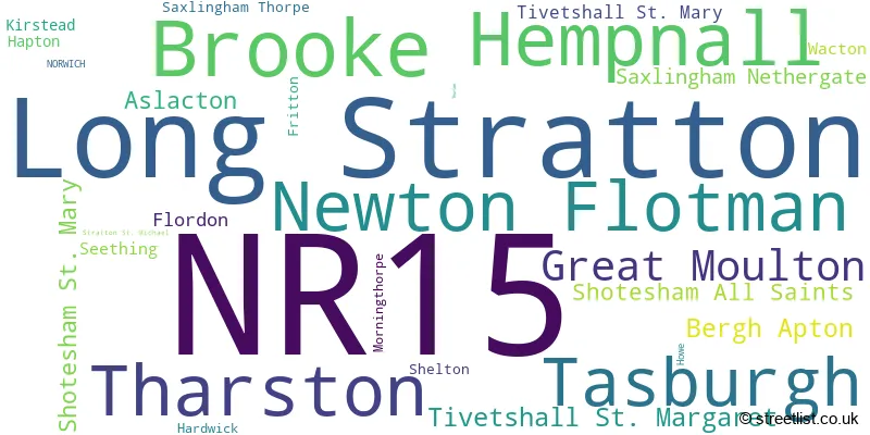
The largest settlement in the NR15 postal code is Long Stratton followed by Brooke, and Hempnall.
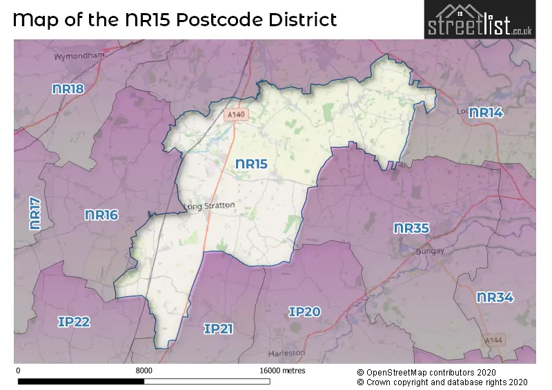
The NR15 Postcode shares a border with IP20 (HARLESTON, Alburgh, Metfield), IP21 (Stradbroke, Fressingfield, Scole), IP22 (DISS, Roydon, Rickinghall), NR35 (BUNGAY, Ditchingham, Earsham), NR14 (Poringland, Mulbarton, Loddon) and NR16 (East Harling, Banham, Bunwell).
The NR15 postcode district in Norfolk, England, is primarily represented by the settlement of Norwich. Other significant settlements in the district include Bergh Apton, Brooke, Flordon, Hapton, Howe, Kirstead, Newton Flotman, Saxlingham Nethergate, Saxlingham Thorpe, Seething, Shotesham All Saints, Shotesham St. Mary, Tasburgh, and Thurton. The most significant post town in the district is Norwich.
For the district NR15, we have data on 2 postcode sectors. Here's a breakdown: The sector NR15 1, covers Brooke and Newton Flotman and Tasburgh in Norfolk. The sector NR15 2, covers Long Stratton and Hempnall and Tharston and Great Moulton in Norfolk.

Map of the NR15 Postcode District
Explore the NR15 postcode district by using our free interactive map.
When it comes to local government, postal geography often disregards political borders. However, for a breakdown in the NR15 District: the district mostly encompasses the South Norfolk District area with a total of 603 postcodes.
Recent House Sales in NR15
| Date | Price | Address |
|---|---|---|
| 23/10/2023 | £245,000 | Bainard Rise, Hempnall, Norwich, NR15 2NB |
| 23/10/2023 | £377,000 | Burgess Way, Brooke, Norwich, NR15 1JY |
| 19/10/2023 | £405,000 | Grove Dale, Newton Flotman, Norwich, NR15 1QG |
| 04/10/2023 | £210,000 | St Davids Close, Long Stratton, Norwich, NR15 2PP |
| 29/09/2023 | £172,500 | Coopers Close, Aslacton, Norwich, NR15 2FA |
| 29/09/2023 | £282,000 | St Marys Close, Newton Flotman, Norwich, NR15 1AH |
| 29/09/2023 | £450,000 | Drovers Rest, Kirstead, Norwich, NR15 1EW |
| 27/09/2023 | £315,000 | Churchfields Road, Long Stratton, Norwich, NR15 2WH |
| 26/09/2023 | £307,000 | Flordon Road, Newton Flotman, Norwich, NR15 1QX |
| 22/09/2023 | £490,000 | Hawes Green, Shotesham St Mary, Norwich, NR15 1UP |
Weather Forecast for NR15
Press Button to Show Forecast for Rainthorpe Hall
| Time Period | Icon | Description | Temperature | Rain Probability | Wind |
|---|---|---|---|---|---|
| 15:00 to 18:00 | Light rain | 7.0°C (feels like 5.0°C) | 44.00% | NNW 7 mph | |
| 18:00 to 21:00 | Sunny day | 6.0°C (feels like 4.0°C) | 1.00% | N 7 mph | |
| 21:00 to 00:00 | Clear night | 2.0°C (feels like 0.0°C) | 0.00% | NW 4 mph |
Press Button to Show Forecast for Rainthorpe Hall
| Time Period | Icon | Description | Temperature | Rain Probability | Wind |
|---|---|---|---|---|---|
| 00:00 to 03:00 | Clear night | 1.0°C (feels like -1.0°C) | 0.00% | WNW 4 mph | |
| 03:00 to 06:00 | Clear night | 0.0°C (feels like -2.0°C) | 1.00% | WNW 4 mph | |
| 06:00 to 09:00 | Cloudy | 3.0°C (feels like 1.0°C) | 3.00% | NW 4 mph | |
| 09:00 to 12:00 | Cloudy | 8.0°C (feels like 6.0°C) | 4.00% | NE 4 mph | |
| 12:00 to 15:00 | Cloudy | 9.0°C (feels like 8.0°C) | 43.00% | NE 4 mph | |
| 15:00 to 18:00 | Cloudy | 9.0°C (feels like 8.0°C) | 11.00% | ENE 7 mph | |
| 18:00 to 21:00 | Cloudy | 8.0°C (feels like 6.0°C) | 7.00% | E 7 mph | |
| 21:00 to 00:00 | Cloudy | 5.0°C (feels like 3.0°C) | 7.00% | ENE 4 mph |
Press Button to Show Forecast for Rainthorpe Hall
| Time Period | Icon | Description | Temperature | Rain Probability | Wind |
|---|---|---|---|---|---|
| 00:00 to 03:00 | Cloudy | 4.0°C (feels like 2.0°C) | 9.00% | NE 4 mph | |
| 03:00 to 06:00 | Partly cloudy (night) | 3.0°C (feels like 1.0°C) | 9.00% | NE 7 mph | |
| 06:00 to 09:00 | Cloudy | 5.0°C (feels like 3.0°C) | 12.00% | NE 7 mph | |
| 09:00 to 12:00 | Overcast | 9.0°C (feels like 7.0°C) | 19.00% | ENE 9 mph | |
| 12:00 to 15:00 | Overcast | 11.0°C (feels like 9.0°C) | 17.00% | E 9 mph | |
| 15:00 to 18:00 | Cloudy | 11.0°C (feels like 9.0°C) | 12.00% | ENE 9 mph | |
| 18:00 to 21:00 | Cloudy | 10.0°C (feels like 8.0°C) | 12.00% | ENE 11 mph | |
| 21:00 to 00:00 | Light rain | 9.0°C (feels like 6.0°C) | 50.00% | ENE 9 mph |
Press Button to Show Forecast for Rainthorpe Hall
| Time Period | Icon | Description | Temperature | Rain Probability | Wind |
|---|---|---|---|---|---|
| 00:00 to 03:00 | Light rain | 9.0°C (feels like 7.0°C) | 51.00% | ENE 11 mph | |
| 03:00 to 06:00 | Heavy rain | 10.0°C (feels like 8.0°C) | 72.00% | E 9 mph | |
| 06:00 to 09:00 | Light rain shower (day) | 10.0°C (feels like 8.0°C) | 43.00% | SE 11 mph | |
| 09:00 to 12:00 | Light rain shower (day) | 12.0°C (feels like 10.0°C) | 39.00% | SSE 13 mph | |
| 12:00 to 15:00 | Light rain shower (day) | 13.0°C (feels like 10.0°C) | 43.00% | SSE 16 mph | |
| 15:00 to 18:00 | Light rain shower (day) | 13.0°C (feels like 10.0°C) | 41.00% | SSW 13 mph | |
| 18:00 to 21:00 | Partly cloudy (day) | 12.0°C (feels like 10.0°C) | 13.00% | SW 11 mph | |
| 21:00 to 00:00 | Partly cloudy (night) | 9.0°C (feels like 7.0°C) | 4.00% | WSW 9 mph |
Where is the NR15 Postcode District?
The NR15 postcode district is located in NORWICH. It is situated approximately 5.8 miles South of HARLESTON, 7.8 miles South East of BUNGAY, 8.9 miles North West of WYMONDHAM, 10 miles South West of DISS, 11.6 miles West of ATTLEBOROUGH, and 12.8 miles East of BECCLES. Additionally, it is approximately 91.4 miles away from the centre of London.
The district is within the post town of NORWICH.
The sector has postcodes within the nation of England.
The NR15 Postcode District is covers the following regions.
- Breckland and South Norfolk - East Anglia - East of England
- Norwich and East Norfolk - East Anglia - East of England
| Postcode Sector | Delivery Office |
|---|---|
| NR15 1 | Brooke Scale Payment Delivery Office |
| NR15 1 | Newton Flotman Scale Payment Delivery Office |
| NR15 1 | Long Stratton Scale Payment Delivery Office |
| NR15 2 | Long Stratton Scale Payment Delivery Office |
| N | R | 1 | 5 | - | X | X | X |
| N | R | 1 | 5 | Space | Numeric | Letter | Letter |
Tourist Attractions within the Postcode Area
We found 1 visitor attractions within the NR15 postcode area
| Moulton Mill |
|---|
| Historic Properties |
| Other Historic / Scenic Transport Operator |
| View Moulton Mill on Google Maps |
Current Monthly Rental Prices
| # Bedrooms | Min Price | Max Price | Avg Price |
|---|---|---|---|
| 3 | £1,250 | £1,250 | £1,250 |
| 4 | £1,395 | £1,800 | £1,554 |
Current House Prices
| # Bedrooms | Min Price | Max Price | Avg Price |
|---|---|---|---|
| £30,000 | £4,500,000 | £1,096,667 | |
| 1 | £150,000 | £180,000 | £165,000 |
| 2 | £190,000 | £285,000 | £237,857 |
| 3 | £130,000 | £750,000 | £354,202 |
| 4 | £160,000 | £1,595,000 | £548,673 |
| 5 | £425,000 | £2,250,000 | £802,857 |
| 6 | £428,000 | £1,425,000 | £1,000,600 |
| 7 | £900,000 | £900,000 | £900,000 |
| 8 | £2,950,000 | £2,950,000 | £2,950,000 |
Estate Agents who Operate in the NR15 District
| Logo | Name | Brand Name | Address | Contact Number | Total Properties |
|---|---|---|---|---|---|
 | Long Stratton | Whittley Parish | Beatrix Potter Cottage The Street, Long Stratton, NR15 2XJ | 01508 505536 | 23 |
 | Poringland | Starkings & Watson | 2a Shotesham Road, Poringland, NR14 7LE | 01508 356456 | 15 |
 | Poringland | Winkworth | Unit 2 Overtons Way, Poringland, NR14 7WB | 01508 528880 | 13 |
 | covering Long Stratton | Howards | The Street, Long Stratton, NR15 2XG | 01508 505543 | 12 |
 | Long Stratton | Martin Smith Partnership | Jubilee House The Street Long Stratton NR15 2XJ | 01508 505236 | 9 |
- Alpington
- Aslacton
- Bergh Apton
- Brooke
- Flordon
- Fritton
- Great Moulton
- Hapton
- Hardwick
- Hawes' Green
- Hellington Corner
- Hempnall Green
- Hempnall
- Howe
- Kirstead Green
- Long Row
- Long Stratton
- Low Tharston
- Lower Tasburgh
- Lundy Green
- Morningthorpe
- Mundham Common
- Newton Flotman
- Saxlingham Nethergate
- Saxlingham Thorpe
- Seething
- Shelton
- Shotesham
- Sneath Common
- Stratton St Michael
- Swainsthorpe
- Tasburgh
- Tharston
- Thurton
- Tivetshall St Margaret
- Tivetshall St Mary
- Topcroft
- Toprow
- Upgate
- Wacton
| Type of Property | 2018 Average | 2018 Sales | 2017 Average | 2017 Sales | 2016 Average | 2016 Sales | 2015 Average | 2015 Sales |
|---|---|---|---|---|---|---|---|---|
| Detached | £323,137 | 125 | £343,438 | 139 | £333,124 | 134 | £312,971 | 151 |
| Semi-Detached | £225,013 | 88 | £207,548 | 95 | £218,928 | 70 | £193,061 | 63 |
| Terraced | £206,622 | 47 | £180,403 | 31 | £182,119 | 39 | £154,754 | 35 |
| Flats | £100,000 | 1 | £132,500 | 4 | £137,850 | 2 | £92,500 | 2 |