The PE6 postcode district is a postal district located in the PE Peterborough postcode area with a population of 39,581 residents according to the 2021 England and Wales Census.
The area of the PE6 postcode district is 119.32 square miles which is 309.04 square kilometres or 76,366.32 acres.
Currently, the PE6 district has about 985 postcode units spread across 4 geographic postcode sectors.
Given that each sector allows for 400 unique postcode combinations, the district has a capacity of 1,600 postcodes. With 985 postcodes already in use, this leaves 615 units available.
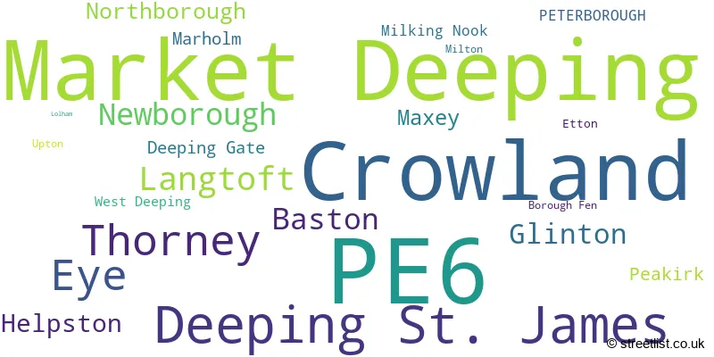
The largest settlement in the PE6 postal code is Market Deeping followed by Deeping St. James, and Crowland.
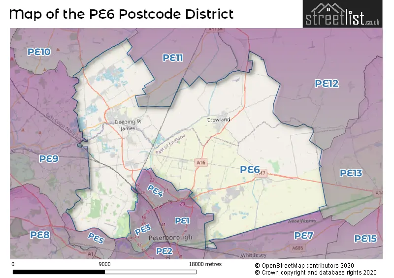
The PE6 Postcode shares a border with PE4 (PETERBOROUGH, Werrington), PE7 (Whittlesey, Yaxley, Hampton Vale), PE3 (PETERBOROUGH, Bretton, Longthorpe), PE5 (Castor, Ailsworth, Sutton), PE13 (WISBECH, Leverington, Wisbech St. Mary), PE9 (STAMFORD, Ketton, Tallington), PE1 (PETERBOROUGH), PE10 (BOURNE, Morton, Thurlby), PE11 (SPALDING, Pinchbeck, Donington), PE2 (PETERBOROUGH, Orton Goldhay, Orton Malborne) and PE12 (Holbeach, Long Sutton, Sutton Bridge).
The primary settlement in the PE6 postcode district is Crowland, located in the county of Lincolnshire in England. The most significant post town in this district is Peterborough. Other significant settlements within the PE6 district include Thorney, Borough Fen, Etton, Eye, Glinton, Helpston, Marholm, Milking Nook, Milton, Newborough, Peakirk, Upton, Deeping St. James, Market Deeping, Baston, Deeping Gate, Langtoft, Lolham, Maxey, Northborough, and West Deeping.
For the district PE6, we have data on 5 postcode sectors. Here's a breakdown: The sector PE6 0, covers Crowland in Lincolnshire. The sector PE6 0, covers Thorney in Cambridgeshire. The sector PE6 6 is non-geographic. It's often designated for PO Boxes, large organisations, or special services. The sector PE6 7, covers Eye and Newborough and Glinton and Helpston in Cambridgeshire. The sector PE6 8, covers Market Deeping and Deeping St. James in Lincolnshire. The sector PE6 9, covers Langtoft and Baston in Lincolnshire. The sector PE6 9, covers Northborough and Maxey in Cambridgeshire.

Map of the PE6 Postcode District
Explore the PE6 postcode district by using our free interactive map.
When it comes to local government, postal geography often disregards political borders. However, for a breakdown in the PE6 District: the district mostly encompasses the City of Peterborough (B) (455 postcodes), followed by the South Kesteven District area (407 postcodes), and finally, the South Holland District area (166 postcodes).
Recent House Sales in PE6
| Date | Price | Address |
|---|---|---|
| 13/10/2023 | £250,000 | Towning Close, Deeping St James, Peterborough, PE6 8HS |
| 29/09/2023 | £253,000 | Althorpe Close, Market Deeping, Peterborough, PE6 8BL |
| 22/09/2023 | £315,000 | Kingsgate, Market Deeping, Peterborough, PE6 8GH |
| 22/09/2023 | £100,000 | Reform Street, Crowland, Peterborough, PE6 0AN |
| 22/09/2023 | £650,000 | Deeping St James Road, Northborough, Peterborough, PE6 9BQ |
| 22/09/2023 | £210,000 | Ash Close, Langtoft, Peterborough, PE6 9LQ |
| 19/09/2023 | £200,000 | Wisbech Road, Thorney, Peterborough, PE6 0SE |
| 15/09/2023 | £310,000 | Welmore Road, Glinton, Peterborough, PE6 7LU |
| 12/09/2023 | £423,500 | High Street, Maxey, Peterborough, PE6 9EE |
| 08/09/2023 | £285,000 | Bede Road, Baston, Peterborough, PE6 9PZ |
Weather Forecast for PE6
Press Button to Show Forecast for Crowland
| Time Period | Icon | Description | Temperature | Rain Probability | Wind |
|---|---|---|---|---|---|
| 03:00 to 06:00 | Cloudy | 4.0°C (feels like 2.0°C) | 3.00% | SW 7 mph | |
| 06:00 to 09:00 | Cloudy | 5.0°C (feels like 2.0°C) | 7.00% | WSW 9 mph | |
| 09:00 to 12:00 | Light rain | 7.0°C (feels like 4.0°C) | 50.00% | W 11 mph | |
| 12:00 to 15:00 | Light rain | 8.0°C (feels like 5.0°C) | 47.00% | NNW 11 mph | |
| 15:00 to 18:00 | Cloudy | 8.0°C (feels like 6.0°C) | 12.00% | NNE 7 mph | |
| 18:00 to 21:00 | Cloudy | 7.0°C (feels like 5.0°C) | 11.00% | E 4 mph | |
| 21:00 to 00:00 | Clear night | 4.0°C (feels like 2.0°C) | 0.00% | NE 4 mph |
Press Button to Show Forecast for Crowland
| Time Period | Icon | Description | Temperature | Rain Probability | Wind |
|---|---|---|---|---|---|
| 00:00 to 03:00 | Clear night | 1.0°C (feels like -1.0°C) | 0.00% | N 4 mph | |
| 03:00 to 06:00 | Clear night | 1.0°C (feels like -2.0°C) | 0.00% | NNW 4 mph | |
| 06:00 to 09:00 | Sunny day | 2.0°C (feels like -1.0°C) | 1.00% | N 4 mph | |
| 09:00 to 12:00 | Partly cloudy (day) | 8.0°C (feels like 6.0°C) | 1.00% | NNE 7 mph | |
| 12:00 to 15:00 | Cloudy | 9.0°C (feels like 8.0°C) | 10.00% | ENE 7 mph | |
| 15:00 to 18:00 | Light rain | 9.0°C (feels like 7.0°C) | 40.00% | ENE 7 mph | |
| 18:00 to 21:00 | Cloudy | 8.0°C (feels like 6.0°C) | 9.00% | ENE 7 mph | |
| 21:00 to 00:00 | Cloudy | 6.0°C (feels like 5.0°C) | 10.00% | NE 4 mph |
Press Button to Show Forecast for Crowland
| Time Period | Icon | Description | Temperature | Rain Probability | Wind |
|---|---|---|---|---|---|
| 00:00 to 03:00 | Cloudy | 5.0°C (feels like 3.0°C) | 9.00% | ENE 4 mph | |
| 03:00 to 06:00 | Partly cloudy (night) | 3.0°C (feels like 1.0°C) | 6.00% | NE 4 mph | |
| 06:00 to 09:00 | Cloudy | 5.0°C (feels like 3.0°C) | 11.00% | NE 7 mph | |
| 09:00 to 12:00 | Cloudy | 9.0°C (feels like 7.0°C) | 15.00% | ENE 9 mph | |
| 12:00 to 15:00 | Cloudy | 11.0°C (feels like 8.0°C) | 17.00% | ENE 11 mph | |
| 15:00 to 18:00 | Cloudy | 11.0°C (feels like 9.0°C) | 14.00% | ENE 11 mph | |
| 18:00 to 21:00 | Cloudy | 10.0°C (feels like 7.0°C) | 15.00% | ENE 11 mph | |
| 21:00 to 00:00 | Light rain | 8.0°C (feels like 5.0°C) | 51.00% | NE 11 mph |
Press Button to Show Forecast for Crowland
| Time Period | Icon | Description | Temperature | Rain Probability | Wind |
|---|---|---|---|---|---|
| 00:00 to 03:00 | Light rain | 8.0°C (feels like 5.0°C) | 47.00% | NE 11 mph | |
| 03:00 to 06:00 | Heavy rain | 8.0°C (feels like 6.0°C) | 75.00% | NE 11 mph | |
| 06:00 to 09:00 | Heavy rain | 9.0°C (feels like 7.0°C) | 76.00% | ENE 9 mph | |
| 09:00 to 12:00 | Light rain shower (day) | 12.0°C (feels like 10.0°C) | 42.00% | ESE 11 mph | |
| 12:00 to 15:00 | Light rain shower (day) | 12.0°C (feels like 11.0°C) | 46.00% | SSE 9 mph | |
| 15:00 to 18:00 | Heavy rain shower (day) | 12.0°C (feels like 10.0°C) | 59.00% | W 11 mph | |
| 18:00 to 21:00 | Light rain shower (day) | 11.0°C (feels like 8.0°C) | 34.00% | SW 11 mph | |
| 21:00 to 00:00 | Cloudy | 9.0°C (feels like 7.0°C) | 9.00% | SSW 7 mph |
Where is the PE6 Postcode District?
The postcode district PE6 is located in Peterborough, which is a district town. Peterborough is situated near several towns. To the north, there is Spalding, which is approximately 8.84 miles away. Towards the northwest, there is Bourne, which is about 10.06 miles away. Stamford is located to the west of Peterborough, at a distance of around 11.88 miles. March is situated to the southeast, approximately 13.43 miles away, while Wisbech is to the east, about 14.78 miles from Peterborough. St. Ives is situated to the south, at a distance of approximately 21.94 miles. Lastly, Corby is located in the southwest, about 23.26 miles away from Peterborough. Furthermore, the distance between Peterborough and London's city center is approximately 79.07 miles.
The district is within the post town of PETERBOROUGH.
The sector has postcodes within the nation of England.
The PE6 Postcode District is covers the following regions.
- Lincolnshire - Lincolnshire - East Midlands (England)
- Peterborough - East Anglia - East of England
| Postcode Sector | Delivery Office |
|---|---|
| PE6 0 | Peterborough Postal Delivery Office |
| PE6 7 | Eye Scale Payment Delivery Office |
| PE6 7 | Glinton Scale Payment Delivery Office |
| PE6 7 | Newborough Scale Payment Delivery Office |
| PE6 7 | Peterborough Postal Delivery Office |
| PE6 8 | Peterborough Postal Delivery Office |
| PE6 8 | Market Deeping Delivery Office |
| PE6 9 | Peterborough Postal Delivery Office |
| PE6 9 | Market Deeping Delivery Office |
| P | E | 6 | - | X | X | X |
| P | E | 6 | Space | Numeric | Letter | Letter |
Tourist Attractions within the Postcode Area
We found 1 visitor attractions within the PE6 postcode area
| Thorney Heritage Museum |
|---|
| Museums & Art Galleries |
| Museum and / or Art Gallery |
| View Thorney Heritage Museum on Google Maps |
Current Monthly Rental Prices
| # Bedrooms | Min Price | Max Price | Avg Price |
|---|---|---|---|
| 1 | £550 | £550 | £550 |
| 2 | £795 | £1,350 | £1,015 |
| 3 | £895 | £1,250 | £1,133 |
| 4 | £1,100 | £2,000 | £1,513 |
| 5 | £2,400 | £2,700 | £2,550 |
Current House Prices
| # Bedrooms | Min Price | Max Price | Avg Price |
|---|---|---|---|
| £60,000 | £2,220,000 | £566,737 | |
| 1 | £125,000 | £300,000 | £212,500 |
| 2 | £65,000 | £1,500,000 | £251,568 |
| 3 | £125,000 | £800,000 | £310,991 |
| 4 | £250,000 | £1,195,000 | £483,838 |
| 5 | £250,000 | £1,095,000 | £610,887 |
| 6 | £495,000 | £2,350,000 | £933,125 |
| 7 | £650,000 | £650,000 | £650,000 |
Estate Agents who Operate in the PE6 District
| Logo | Name | Brand Name | Address | Contact Number | Total Properties |
|---|---|---|---|---|---|
 | Market Deeping | Sharman Quinney | 25 Market Place, Market Deeping, PE6 8EA | 01778 309997 | 35 |
 | Crowland | City & County (UK) Ltd | 11 North Street Crowland PE6 0EG | 01733 964706 | 34 |
 | Market Deeping | Briggs Residential | 17 Market Place Market Deeping PE6 8EA | 01778 349300 | 31 |
 | Castor | Hurfords | 5 The Barns Milton Lane Castor PE5 7DH | 01733 964902 | 23 |
 | Market Deeping | Winkworth | 5a High Street, Market Deeping, PE6 8ED | 01778 301163 | 21 |
- Baston
- Coates
- Cowbit
- Crowland
- Deeping Gate
- Deeping St James
- Deeping St Nicholas
- Dowsdale
- Etton
- Eye Green
- Eye
- Frognall
- Gedney Hill
- Glinton
- Helpston
- Hop Pole
- King's Dyke
- Langtoft
- Marholm
- Market Deeping
- Maxey
- Milking Nook
- Newborough
- Northborough
- Peakirk
- Peterborough
- Shepeau Stow
- Sutton
- Thorney
- Thorney Toll
- Tongue End
- Ufford
- Upton
- West Deeping
- Whittlesey
| Type of Property | 2018 Average | 2018 Sales | 2017 Average | 2017 Sales | 2016 Average | 2016 Sales | 2015 Average | 2015 Sales |
|---|---|---|---|---|---|---|---|---|
| Detached | £311,080 | 361 | £312,912 | 389 | £296,501 | 436 | £262,251 | 442 |
| Semi-Detached | £202,538 | 226 | £199,986 | 236 | £179,823 | 241 | £171,027 | 190 |
| Terraced | £177,527 | 108 | £161,710 | 104 | £158,085 | 116 | £139,219 | 124 |
| Flats | £126,993 | 15 | £125,774 | 16 | £119,625 | 14 | £107,706 | 17 |