The PH42 postcode district is a postal district located in the PH Perth postcode area with a population of 153 residents according to the 2011 Scotland Census.
The area of the PH42 postcode district is 11.38 square miles which is 29.47 square kilometres or 7,281.50 acres.
Currently, the PH42 district has about 1 postcode units spread across 0 geographic postcode sectors.
Given that each sector allows for 400 unique postcode combinations, the district has a capacity of 0 postcodes. With 1 postcodes already in use, this leaves -1 units available.
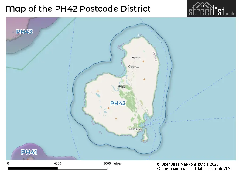
The PH42 postal code covers the settlement of ISLE OF EIGG.
The postcode area has a boundary with Sea of the Hebredes.
The primary settlement in the PH42 postcode district is Isle of Eigg, which is located in the county of Inverness. There are no other significant settlements mentioned. The post town associated with this postcode district is Inverness.
For the district PH42, we have data on 1 postcode sectors. Here's a breakdown: The sector PH42 4 is non-geographic. It's often designated for PO Boxes, large organisations, or special services.
PH42 Postcode Sectors

Map of the PH42 Postcode District
Explore the PH42 postcode district by using our free interactive map.
There are no postcodes assigned to any local authorities in the PH42 District.
Where is the PH42 Postcode District?
The postcode district for PH42 is located in the town of Isle of Eigg. This town is nearby other towns such as Isle of Rum, Arisaig, Mallaig, Acharacle, and Isle of Coll. The distance from the postcode district to the center of London is 445.68 miles.
The district is within the post town of ISLE OF EIGG.
The sector has postcodes within the nation of Scotland.
The PH42 Postcode District is covers the following regions.
- Caithness & Sutherland and Ross & Cromarty - Highlands and Islands - Scotland
- Inverness & Nairn and Moray, Badenoch & Strathspey - Highlands and Islands - Scotland
- Lochaber, Skye & Lochalsh, Arran & Cumbrae and Argyll & Bute - Highlands and Islands - Scotland
Postcode Sectors within the PH42 District
Postcode Districts that Share a Border with PH42
| Postcode Sector | Delivery Office |
|---|---|
| PH42 4 | Isle Of Eigg Scale Payment Delivery Office |
| P | H | 4 | 2 | - | X | X | X |
| P | H | 4 | 2 | Space | Numeric | Letter | Letter |
Current Monthly Rental Prices
| # Bedrooms | Min Price | Max Price | Avg Price |
|---|
Current House Prices
| # Bedrooms | Min Price | Max Price | Avg Price |
|---|
Estate Agents who Operate in the PH42 District
| Logo | Name | Brand Name | Address | Contact Number | Total Properties |
|---|