The PO15 postcode district is a postal district located in the PO Portsmouth postcode area with a population of 23,064 residents according to the 2021 England and Wales Census.
The area of the PO15 postcode district is 6.93 square miles which is 17.96 square kilometres or 4,437.69 acres.
Currently, the PO15 district has about 663 postcode units spread across 3 geographic postcode sectors.
Given that each sector allows for 400 unique postcode combinations, the district has a capacity of 1,200 postcodes. With 663 postcodes already in use, this leaves 537 units available.
The largest settlement in the PO15 postal code is FAREHAM followed by Whiteley, and Titchfield.
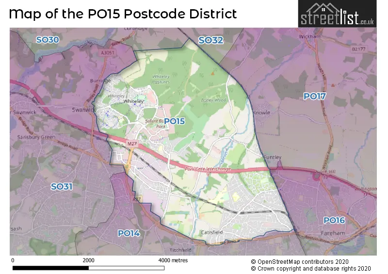
The PO15 Postcode shares a border with PO17 (Wickham, Knowle, North Boarhunt), SO31 (Locks Heath, Bursledon, Warsash), PO14 (FAREHAM, Titchfield, Stubbington) and PO16 (FAREHAM, Portchester).
The primary settlement in the PO15 postcode district is Fareham, which is located in the county of Hampshire, England. Other significant settlements include Segensworth West, Titchfield, Knowle, Wickham, and Whiteley.
For the district PO15, we have data on 3 postcode sectors. Here's a breakdown: The sector PO15 5, covers Fareham in Hampshire. The sector PO15 6, covers Fareham in Hampshire. The sector PO15 7, covers Whiteley in Hampshire.


Map of the PO15 Postcode District
Explore the PO15 postcode district by using our free interactive map.
When it comes to local government, postal geography often disregards political borders. However, for a breakdown in the PO15 District: the district mostly encompasses the Fareham District (B) (521 postcodes), and finally, the Winchester District (B) area (172 postcodes).
Recent House Sales in PO15
| Date | Price | Address |
|---|---|---|
| 04/10/2023 | £400,000 | Abbots Way, Fareham, PO15 5BX |
| 29/09/2023 | £122,500 | Highlands Road, Fareham, PO15 6HL |
| 27/09/2023 | £458,000 | Stag Way, Funtley, Fareham, PO15 6TW |
| 07/09/2023 | £475,000 | East Lodge, Fareham, PO15 5LZ |
| 04/09/2023 | £439,000 | Larches Gardens, Fareham, PO15 5LR |
| 01/09/2023 | £155,000 | Oak Coppice Road, Whiteley, Fareham, PO15 7GU |
| 01/09/2023 | £490,000 | Regency Place, Fareham, PO15 5JF |
| 30/08/2023 | £380,000 | Southmead Road, Fareham, PO15 5JZ |
| 25/08/2023 | £290,000 | Walton Court, Fareham, PO15 6EZ |
| 25/08/2023 | £300,000 | Andersen Close, Whiteley, Fareham, PO15 7ER |
Weather Forecast for PO15
Press Button to Show Forecast for Catisfield
| Time Period | Icon | Description | Temperature | Rain Probability | Wind |
|---|---|---|---|---|---|
| 00:00 to 03:00 | Clear night | 7.0°C (feels like 5.0°C) | 0.00% | NNE 7 mph | |
| 03:00 to 06:00 | Clear night | 4.0°C (feels like 2.0°C) | 0.00% | N 4 mph | |
| 06:00 to 09:00 | Sunny day | 4.0°C (feels like 2.0°C) | 0.00% | N 4 mph | |
| 09:00 to 12:00 | Partly cloudy (day) | 8.0°C (feels like 6.0°C) | 1.00% | N 9 mph | |
| 12:00 to 15:00 | Cloudy | 11.0°C (feels like 9.0°C) | 4.00% | N 11 mph | |
| 15:00 to 18:00 | Cloudy | 12.0°C (feels like 10.0°C) | 4.00% | N 11 mph | |
| 18:00 to 21:00 | Cloudy | 11.0°C (feels like 9.0°C) | 4.00% | N 9 mph | |
| 21:00 to 00:00 | Cloudy | 8.0°C (feels like 7.0°C) | 4.00% | NNE 4 mph |
Press Button to Show Forecast for Catisfield
| Time Period | Icon | Description | Temperature | Rain Probability | Wind |
|---|---|---|---|---|---|
| 00:00 to 03:00 | Partly cloudy (night) | 7.0°C (feels like 6.0°C) | 1.00% | NNE 4 mph | |
| 03:00 to 06:00 | Partly cloudy (night) | 6.0°C (feels like 4.0°C) | 1.00% | N 4 mph | |
| 06:00 to 09:00 | Cloudy | 6.0°C (feels like 4.0°C) | 5.00% | NNE 7 mph | |
| 09:00 to 12:00 | Overcast | 8.0°C (feels like 6.0°C) | 7.00% | NNE 9 mph | |
| 12:00 to 15:00 | Overcast | 10.0°C (feels like 8.0°C) | 8.00% | NNE 11 mph | |
| 15:00 to 18:00 | Overcast | 11.0°C (feels like 9.0°C) | 8.00% | NNE 11 mph | |
| 18:00 to 21:00 | Partly cloudy (day) | 10.0°C (feels like 8.0°C) | 3.00% | NNE 11 mph | |
| 21:00 to 00:00 | Clear night | 8.0°C (feels like 6.0°C) | 2.00% | NNE 9 mph |
Press Button to Show Forecast for Catisfield
| Time Period | Icon | Description | Temperature | Rain Probability | Wind |
|---|---|---|---|---|---|
| 00:00 to 03:00 | Clear night | 6.0°C (feels like 4.0°C) | 3.00% | NE 9 mph | |
| 03:00 to 06:00 | Clear night | 4.0°C (feels like 2.0°C) | 3.00% | NNE 7 mph | |
| 06:00 to 09:00 | Sunny day | 5.0°C (feels like 2.0°C) | 3.00% | NNE 7 mph | |
| 09:00 to 12:00 | Cloudy | 8.0°C (feels like 6.0°C) | 7.00% | NNE 7 mph | |
| 12:00 to 15:00 | Cloudy | 10.0°C (feels like 9.0°C) | 11.00% | N 7 mph | |
| 15:00 to 18:00 | Overcast | 10.0°C (feels like 9.0°C) | 16.00% | NNW 7 mph | |
| 18:00 to 21:00 | Cloudy | 9.0°C (feels like 7.0°C) | 16.00% | NNW 9 mph | |
| 21:00 to 00:00 | Light rain | 8.0°C (feels like 6.0°C) | 45.00% | N 7 mph |
Press Button to Show Forecast for Catisfield
| Time Period | Icon | Description | Temperature | Rain Probability | Wind |
|---|---|---|---|---|---|
| 00:00 to 03:00 | Cloudy | 7.0°C (feels like 5.0°C) | 11.00% | N 7 mph | |
| 03:00 to 06:00 | Cloudy | 7.0°C (feels like 5.0°C) | 8.00% | NNE 7 mph | |
| 06:00 to 09:00 | Cloudy | 6.0°C (feels like 4.0°C) | 7.00% | NNE 7 mph | |
| 09:00 to 12:00 | Partly cloudy (day) | 9.0°C (feels like 7.0°C) | 4.00% | NNE 9 mph | |
| 12:00 to 15:00 | Cloudy | 11.0°C (feels like 9.0°C) | 10.00% | NE 9 mph | |
| 15:00 to 18:00 | Cloudy | 12.0°C (feels like 10.0°C) | 10.00% | NNE 9 mph | |
| 18:00 to 21:00 | Cloudy | 11.0°C (feels like 10.0°C) | 7.00% | N 9 mph | |
| 21:00 to 00:00 | Partly cloudy (night) | 9.0°C (feels like 8.0°C) | 4.00% | N 7 mph |
Where is the PO15 Postcode District?
The data indicates that the postcode district for PO15 is located in Fareham, a town situated in the South of England. Fareham shares its borders with several nearby towns, including Lee-on-the-Solent to the South (5.06 miles away), Gosport to the South East (5.78 miles away), Southampton to the North West (7.85 miles away), and Waterlooville to the East (9.69 miles away). Additionally, Fareham is approximately 64.92 miles away from the center of London.
The district is within the post town of FAREHAM.
The sector has postcodes within the nation of England.
The PO15 Postcode District is covers the following regions.
- South Hampshire - Hampshire and Isle of Wight - South East (England)
- Central Hampshire - Hampshire and Isle of Wight - South East (England)
| Postcode Sector | Delivery Office |
|---|---|
| PO15 5 | Fareham Delivery Office |
| PO15 6 | Fareham Delivery Office |
| PO15 7 | Fareham Delivery Office |
| P | O | 1 | 5 | - | X | X | X |
| P | O | 1 | 5 | Space | Numeric | Letter | Letter |
Current Monthly Rental Prices
| # Bedrooms | Min Price | Max Price | Avg Price |
|---|---|---|---|
| 2 | £975 | £1,500 | £1,145 |
| 3 | £1,350 | £1,650 | £1,453 |
| 4 | £1,900 | £1,900 | £1,900 |
Current House Prices
| # Bedrooms | Min Price | Max Price | Avg Price |
|---|---|---|---|
| £1 | £100 | £51 | |
| 1 | £164,950 | £170,000 | £167,475 |
| 2 | £130,000 | £615,000 | £301,026 |
| 3 | £190,000 | £630,000 | £395,424 |
| 4 | £262,000 | £1,250,000 | £523,294 |
| 5 | £414,995 | £1,950,000 | £926,500 |
| 6 | £570,000 | £1,800,000 | £1,072,500 |
| 8 | £2,600,000 | £2,600,000 | £2,600,000 |
Estate Agents who Operate in the PO15 District
| Logo | Name | Brand Name | Address | Contact Number | Total Properties |
|---|---|---|---|---|---|
 | Park Gate | Walker & Waterer Ltd | 20e Bridge Road, Park Gate, Southampton, Hampshire, SO31 7GE | 01489 577990 | 39 |
 | Fareham | Pearsons | 21 West Street, Fareham, PO16 0BG | 01329 288241 | 28 |
 | Fareham | Chapplins Estate Agents | 9-11 West St, Ground Floor Offices, Fareham, PO16 0BG | 01329 557322 | 17 |
 | Park Gate | Charters | 39 Middle Road, Park Gate, SO31 7GH | 01489 539487 | 13 |
 | Fareham | Fenwicks Estate Agents | 3 West Street, Fareham, PO16 0BG | 01329 551192 | 9 |
| Type of Property | 2018 Average | 2018 Sales | 2017 Average | 2017 Sales | 2016 Average | 2016 Sales | 2015 Average | 2015 Sales |
|---|---|---|---|---|---|---|---|---|
| Detached | £420,800 | 134 | £421,096 | 151 | £391,015 | 153 | £356,006 | 178 |
| Semi-Detached | £275,969 | 143 | £269,563 | 132 | £256,752 | 123 | £236,905 | 144 |
| Terraced | £258,921 | 106 | £249,324 | 104 | £235,785 | 103 | £222,846 | 87 |
| Flats | £164,436 | 47 | £168,719 | 58 | £156,287 | 64 | £148,072 | 62 |
Hotels within the Postcode Area
We found 3 hotels and guest houses within the PO15 postcode area
Solent Hotel and Spa - A Thwaites Hotel and Spa
Rookery Avenue, Whiteley, Fareham, fareham, PO15 7AJ.
View details