The PR6 postcode district is a postal district located in the PR Preston postcode area with a population of 36,207 residents according to the 2021 England and Wales Census.
The area of the PR6 postcode district is 27.64 square miles which is 71.59 square kilometres or 17,689.99 acres.
Currently, the PR6 district has about 1041 postcode units spread across 4 geographic postcode sectors.
Given that each sector allows for 400 unique postcode combinations, the district has a capacity of 1,600 postcodes. With 1041 postcodes already in use, this leaves 559 units available.
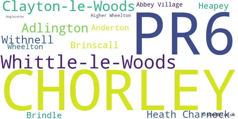
The largest settlement in the PR6 postal code is CHORLEY followed by Whittle-le-Woods, and Clayton-le-Woods.
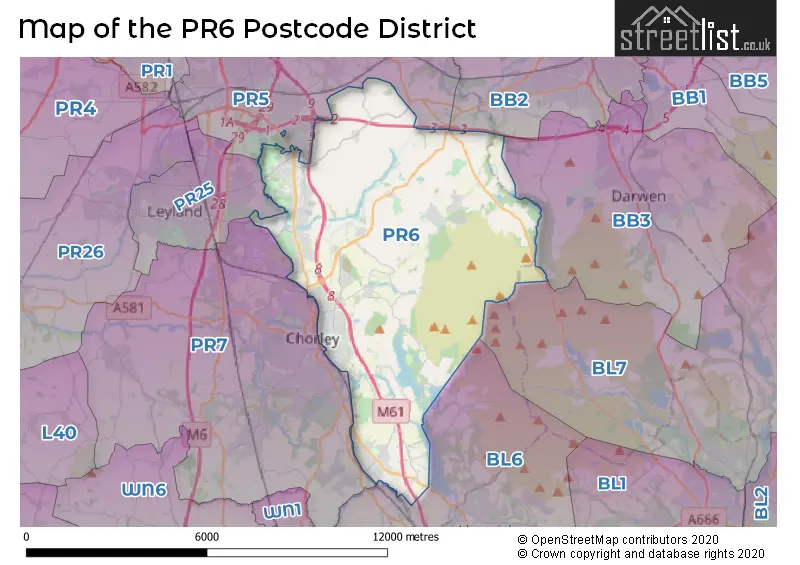
The PR6 Postcode shares a border with PR25 (LEYLAND, Farington), PR5 (Bamber Bridge, Lostock Hall, Walton-le-Dale), PR7 (CHORLEY, Euxton, Buckshaw Village), BL6 (Horwich, Lostock, Blackrod), BL7 (Bromley Cross, Egerton, Turton) and BB3 (DARWEN, Lower Darwen, Hoddlesden).
The primary settlement in the PR6 postcode district is Chorley, located in the county of Lancashire, England. Other significant settlements in this district include Brindle, Clayton-le-Woods, Whittle-le-Woods, Abbey Village, Brinscall, Heapey, Higher Wheelton, Wheelton, Withnell, Adlington, Anderton, Anglezarke, and Heath Charnock. The most significant post town in this district is Chorley.
For the district PR6, we have data on 5 postcode sectors. Here's a breakdown: The sector PR6 0, covers Chorley in Lancashire. The sector PR6 6 is non-geographic. It's often designated for PO Boxes, large organisations, or special services. The sector PR6 7, covers Whittle-Le-Woods and Clayton-Le-Woods and Chorley in Lancashire. The sector PR6 8, covers Withnell and Brinscall and Brindle and Wheelton in Lancashire. The sector PR6 9, covers Adlington and Heath Charnock and Anderton and Chorley in Lancashire.

Map of the PR6 Postcode District
Explore the PR6 postcode district by using our free interactive map.
When it comes to local government, postal geography often disregards political borders. However, for a breakdown in the PR6 District: the district mostly encompasses the Chorley District (B) area with a total of 1031 postcodes.
Recent House Sales in PR6
| Date | Price | Address |
|---|---|---|
| 20/10/2023 | £320,000 | Ashdown Drive, Clayton Le Woods, Chorley, PR6 7SQ |
| 06/10/2023 | £335,000 | Blackburn Road, Higher Wheelton, Chorley, PR6 8JA |
| 04/10/2023 | £173,500 | Montcliffe Road, Chorley, PR6 0EN |
| 22/09/2023 | £365,000 | Lady Crosse Drive, Whittle Le Woods, Chorley, PR6 7DR |
| 20/09/2023 | £290,000 | Parke Road, Brinscall, Chorley, PR6 8QB |
| 15/09/2023 | £649,995 | Mill Wood Close, Withnell, Chorley, PR6 8AR |
| 15/09/2023 | £55,000 | Cowling Brow, Chorley, PR6 0QG |
| 15/09/2023 | £100,000 | Bowland Avenue, Chorley, PR6 0BN |
| 12/09/2023 | £325,000 | Blackburn Road, Whittle Le Woods, Chorley, PR6 8LH |
| 04/09/2023 | £295,000 | Dark Lane, Whittle Le Woods, Chorley, PR6 8AH |
Weather Forecast for PR6
Press Button to Show Forecast for Chorley
| Time Period | Icon | Description | Temperature | Rain Probability | Wind |
|---|---|---|---|---|---|
| 06:00 to 09:00 | Cloudy | 8.0°C (feels like 4.0°C) | 43.00% | NW 13 mph | |
| 09:00 to 12:00 | Cloudy | 9.0°C (feels like 5.0°C) | 13.00% | NW 16 mph | |
| 12:00 to 15:00 | Cloudy | 10.0°C (feels like 7.0°C) | 38.00% | NW 18 mph | |
| 15:00 to 18:00 | Cloudy | 10.0°C (feels like 8.0°C) | 50.00% | NNW 13 mph | |
| 18:00 to 21:00 | Cloudy | 10.0°C (feels like 8.0°C) | 4.00% | N 9 mph | |
| 21:00 to 00:00 | Partly cloudy (night) | 7.0°C (feels like 5.0°C) | 1.00% | NNE 7 mph |
Press Button to Show Forecast for Chorley
| Time Period | Icon | Description | Temperature | Rain Probability | Wind |
|---|---|---|---|---|---|
| 00:00 to 03:00 | Partly cloudy (night) | 5.0°C (feels like 4.0°C) | 1.00% | NNE 4 mph | |
| 03:00 to 06:00 | Partly cloudy (night) | 4.0°C (feels like 2.0°C) | 1.00% | NE 4 mph | |
| 06:00 to 09:00 | Partly cloudy (day) | 4.0°C (feels like 2.0°C) | 1.00% | E 2 mph | |
| 09:00 to 12:00 | Sunny day | 7.0°C (feels like 6.0°C) | 1.00% | N 4 mph | |
| 12:00 to 15:00 | Cloudy | 10.0°C (feels like 9.0°C) | 5.00% | NNW 7 mph | |
| 15:00 to 18:00 | Cloudy | 10.0°C (feels like 9.0°C) | 5.00% | NW 7 mph | |
| 18:00 to 21:00 | Partly cloudy (day) | 9.0°C (feels like 8.0°C) | 1.00% | NW 7 mph | |
| 21:00 to 00:00 | Partly cloudy (night) | 6.0°C (feels like 5.0°C) | 1.00% | NNW 4 mph |
Press Button to Show Forecast for Chorley
| Time Period | Icon | Description | Temperature | Rain Probability | Wind |
|---|---|---|---|---|---|
| 00:00 to 03:00 | Partly cloudy (night) | 5.0°C (feels like 4.0°C) | 2.00% | N 2 mph | |
| 03:00 to 06:00 | Cloudy | 4.0°C (feels like 3.0°C) | 5.00% | NNE 2 mph | |
| 06:00 to 09:00 | Cloudy | 6.0°C (feels like 5.0°C) | 13.00% | NNE 2 mph | |
| 09:00 to 12:00 | Cloudy | 9.0°C (feels like 9.0°C) | 5.00% | N 4 mph | |
| 12:00 to 15:00 | Cloudy | 11.0°C (feels like 10.0°C) | 16.00% | N 4 mph | |
| 15:00 to 18:00 | Light rain | 12.0°C (feels like 10.0°C) | 38.00% | NNE 7 mph | |
| 18:00 to 21:00 | Cloudy | 11.0°C (feels like 9.0°C) | 5.00% | NE 7 mph | |
| 21:00 to 00:00 | Partly cloudy (night) | 8.0°C (feels like 6.0°C) | 3.00% | ENE 7 mph |
Press Button to Show Forecast for Chorley
| Time Period | Icon | Description | Temperature | Rain Probability | Wind |
|---|---|---|---|---|---|
| 00:00 to 03:00 | Cloudy | 6.0°C (feels like 4.0°C) | 5.00% | ENE 4 mph | |
| 03:00 to 06:00 | Cloudy | 5.0°C (feels like 4.0°C) | 6.00% | E 4 mph | |
| 06:00 to 09:00 | Cloudy | 6.0°C (feels like 5.0°C) | 6.00% | ENE 4 mph | |
| 09:00 to 12:00 | Cloudy | 9.0°C (feels like 7.0°C) | 6.00% | E 7 mph | |
| 12:00 to 15:00 | Cloudy | 10.0°C (feels like 9.0°C) | 16.00% | ENE 7 mph | |
| 15:00 to 18:00 | Cloudy | 11.0°C (feels like 9.0°C) | 16.00% | NE 7 mph | |
| 18:00 to 21:00 | Cloudy | 10.0°C (feels like 9.0°C) | 7.00% | NE 7 mph | |
| 21:00 to 00:00 | Cloudy | 7.0°C (feels like 6.0°C) | 5.00% | NE 7 mph |
Where is the PR6 Postcode District?
The postcode district PR6 is located in the town of Chorley. This district is in close proximity to several nearby towns. To the West is Leyland, which is approximately 5.18 miles away. To the East is Darwen, approximately 5.42 miles away. In the North East direction, you will find Blackburn, which is around 6.69 miles away. In the North West, you will find Preston, which is approximately 7.12 miles away. Moving towards the South East, Bolton is located around 9.15 miles away. Wigan is in the South direction and is approximately 9.76 miles away. Finally, in the South West direction, you will come across Skelmersdale, which is approximately 11.65 miles away. Additionally, the distance from the PR6 postcode district to the center of London is approximately 182.20 miles.
The district is within the post town of CHORLEY.
The sector has postcodes within the nation of England.
The PR6 Postcode District is covers the following regions.
- Chorley and West Lancashire - Lancashire - North West (England)
- Blackburn with Darwen - Lancashire - North West (England)
| Postcode Sector | Delivery Office |
|---|---|
| PR6 0 | Chorley Delivery Office |
| PR6 7 | Chorley Delivery Office |
| PR6 8 | Chorley Delivery Office |
| PR6 9 | Chorley Delivery Office |
| P | R | 6 | - | X | X | X |
| P | R | 6 | Space | Numeric | Letter | Letter |
Current Monthly Rental Prices
| # Bedrooms | Min Price | Max Price | Avg Price |
|---|---|---|---|
| £350 | £400 | £375 | |
| 1 | £475 | £1,225 | £834 |
| 2 | £650 | £1,860 | £1,106 |
| 3 | £950 | £2,100 | £1,463 |
| 4 | £995 | £1,600 | £1,349 |
Current House Prices
| # Bedrooms | Min Price | Max Price | Avg Price |
|---|---|---|---|
| £59,995 | £1,800,000 | £564,998 | |
| 1 | £49,995 | £110,000 | £78,330 |
| 2 | £70,000 | £480,000 | £186,167 |
| 3 | £75,000 | £895,000 | £287,653 |
| 4 | £159,995 | £1,000,000 | £424,587 |
| 5 | £179,000 | £1,200,000 | £534,091 |
| 6 | £774,995 | £774,995 | £774,995 |
| 7 | £699,995 | £699,995 | £699,995 |
Estate Agents who Operate in the PR6 District
| Logo | Name | Brand Name | Address | Contact Number | Total Properties |
|---|---|---|---|---|---|
 | Chorley | Ben Rose | 12 Cleveland Street, Chorley, PR7 1BH | 01257 445695 | 51 |
 | Chorley | Chesters | Chorley | 01257 445709 | 19 |
 | Chorley | Farrell Heyworth | 13/15 Cleveland Street Chorley PR7 1BH | 01257 445717 | 15 |
 | Chorley | Arnold & Phillips | 24 Market Street, Chorley, PR7 2TD | 01257 444403 | 15 |
 | Chorley | Reeds Rains | 24 High Street, Chorley, PR7 1DW | 01257 440935 | 14 |
- Abbey Village
- Adlington
- Bamber Bridge
- Blackburn
- Brindle
- Brinscall
- Chorley
- Grimeford Village
- Higher Copthurst
- Higher Wheelton
- Hoghton
- Jack Green
- Johnson's Hillock
- Leyland
- Limbrick
- Lower Copthurst
- Pippin Street
- Riley Green
- Rivington
- Ryal Fold
- Thorpe Green
- Tockholes
- Wheelton
- White Coppice
- Whittle-le-Woods
- Withnell
- Withnell Fold
- Worden
| Type of Property | 2018 Average | 2018 Sales | 2017 Average | 2017 Sales | 2016 Average | 2016 Sales | 2015 Average | 2015 Sales |
|---|---|---|---|---|---|---|---|---|
| Detached | £300,606 | 226 | £294,019 | 241 | £288,537 | 264 | £279,777 | 219 |
| Semi-Detached | £156,323 | 165 | £158,325 | 155 | £154,802 | 161 | £152,825 | 152 |
| Terraced | £123,286 | 260 | £123,904 | 250 | £123,015 | 235 | £116,733 | 238 |
| Flats | £109,045 | 10 | £92,667 | 6 | £121,255 | 17 | £88,806 | 8 |
Hotels within the Postcode Area
We found 4 hotels and guest houses within the PR6 postcode area
Hartwood Hall by Good Night Inns
Preston Road, Chorley, chorley-nr-preston-lanc, PR6 7AX.
View detailsShaw Hill Hotel Golf And Country Club
Preston Road, Whittle-Le-Woods, Chorley, chorley-nr-preston-lanc, PR6 7PP.
View detailsOak Royal Golf & Country Club Hotel
Moss Side Farm, Bury Lane, Chorley, withnell, PR6 8SW.
View details