The RG25 postcode district is a postal district located in the RG Reading postcode area with a population of 8,881 residents according to the 2021 England and Wales Census.
The area of the RG25 postcode district is 57.36 square miles which is 148.56 square kilometres or 36,710.01 acres.
Currently, the RG25 district has about 387 postcode units spread across 2 geographic postcode sectors.
Given that each sector allows for 400 unique postcode combinations, the district has a capacity of 800 postcodes. With 387 postcodes already in use, this leaves 413 units available.
The largest settlement in the RG25 postal code is Overton followed by North Waltham, and Upton Grey.
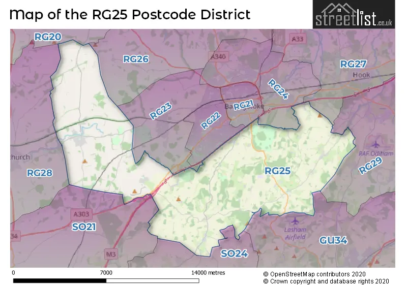
The RG25 Postcode shares a border with RG20 (Kingsclere, Woolton Hill, Compton), RG21 (BASINGSTOKE), RG28 (WHITCHURCH, Hurstbourne Priors, Laverstoke), SO21 (Colden Common, Sutton Scotney, Twyford), GU34 (ALTON, Four Marks, Medstead), RG22 (BASINGSTOKE, Beggarwood, Hatch Warren), RG29 (Odiham, North Warnborough, South Warnborough), SO24 (ALRESFORD, Ropley, Cheriton), RG23 (BASINGSTOKE, Oakley, Dummer), RG24 (BASINGSTOKE, Chineham, Old Basing) and RG26 (TADLEY, Bramley, Baughurst).
The primary settlement in the RG25 postcode district is Basingstoke, located in the county of Hampshire in England. Other significant settlements include Axford, Cliddesden, Dummer, Ellisfield, Farleigh Wallop, Hackwood Park, Herriard, Mapledurwell, Moundsmere, North Waltham, Nutley, Preston Candover, Tunworth, Upton Grey, Weston Corbett, Weston Patrick, and Winslade. The Postal Town for this district is Basingstoke.
For the district RG25, we have data on 2 postcode sectors. Here's a breakdown: The sector RG25 2, covers North Waltham and Upton Grey and Herriard and Dummer in Hampshire. The sector RG25 3, covers Overton in Hampshire.

Map of the RG25 Postcode District
Explore the RG25 postcode district by using our free interactive map.
When it comes to local government, postal geography often disregards political borders. However, for a breakdown in the RG25 District: the district mostly encompasses the Basingstoke and Deane District (B) area with a total of 390 postcodes.
Recent House Sales in RG25
| Date | Price | Address |
|---|---|---|
| 05/10/2023 | £1,100,000 | Manor Farm Cottages, Weston Corbett, Basingstoke, RG25 2PA |
| 29/09/2023 | £485,000 | Overton Hill, Overton, Basingstoke, RG25 3PE |
| 06/09/2023 | £465,000 | Hazelcombe, Overton, Basingstoke, RG25 3NX |
| 31/08/2023 | £325,000 | Crawts Road, Overton, Basingstoke, RG25 3LN |
| 23/08/2023 | £995,000 | Greyhound Lane, Overton, Basingstoke, RG25 3LE |
| 22/08/2023 | £515,000 | Copse Road, Overton, Basingstoke, RG25 3JL |
| 18/08/2023 | £1,026,000 | Upton Grey, Basingstoke, RG25 2RD |
| 09/08/2023 | £1,500,000 | Church Road, North Waltham, Basingstoke, RG25 2BL |
| 08/08/2023 | £775,000 | Hazelcombe, Overton, Basingstoke, RG25 3NX |
| 04/08/2023 | £1,700,000 | The Arboretum, Upton Grey, Basingstoke, RG25 2SG |
Weather Forecast for RG25
Press Button to Show Forecast for Ellisfield
| Time Period | Icon | Description | Temperature | Rain Probability | Wind |
|---|---|---|---|---|---|
| 12:00 to 15:00 | Overcast | 9.0°C (feels like 6.0°C) | 49.00% | WNW 9 mph | |
| 15:00 to 18:00 | Light rain | 9.0°C (feels like 7.0°C) | 51.00% | W 9 mph | |
| 18:00 to 21:00 | Cloudy | 8.0°C (feels like 7.0°C) | 52.00% | WNW 7 mph | |
| 21:00 to 00:00 | Cloudy | 6.0°C (feels like 5.0°C) | 10.00% | NE 4 mph |
Press Button to Show Forecast for Ellisfield
| Time Period | Icon | Description | Temperature | Rain Probability | Wind |
|---|---|---|---|---|---|
| 00:00 to 03:00 | Cloudy | 5.0°C (feels like 3.0°C) | 8.00% | ENE 7 mph | |
| 03:00 to 06:00 | Cloudy | 4.0°C (feels like 1.0°C) | 6.00% | ENE 7 mph | |
| 06:00 to 09:00 | Cloudy | 4.0°C (feels like 1.0°C) | 7.00% | ENE 9 mph | |
| 09:00 to 12:00 | Cloudy | 6.0°C (feels like 3.0°C) | 8.00% | ENE 9 mph | |
| 12:00 to 15:00 | Overcast | 9.0°C (feels like 6.0°C) | 15.00% | ENE 9 mph | |
| 15:00 to 18:00 | Overcast | 9.0°C (feels like 8.0°C) | 18.00% | ENE 7 mph | |
| 18:00 to 21:00 | Cloudy | 8.0°C (feels like 7.0°C) | 12.00% | ENE 7 mph | |
| 21:00 to 00:00 | Cloudy | 6.0°C (feels like 3.0°C) | 14.00% | ENE 7 mph |
Press Button to Show Forecast for Ellisfield
| Time Period | Icon | Description | Temperature | Rain Probability | Wind |
|---|---|---|---|---|---|
| 00:00 to 03:00 | Cloudy | 4.0°C (feels like 1.0°C) | 17.00% | ENE 7 mph | |
| 03:00 to 06:00 | Light rain | 3.0°C (feels like 1.0°C) | 51.00% | ENE 7 mph | |
| 06:00 to 09:00 | Light rain | 4.0°C (feels like 1.0°C) | 48.00% | NE 9 mph | |
| 09:00 to 12:00 | Cloudy | 7.0°C (feels like 5.0°C) | 19.00% | ENE 9 mph | |
| 12:00 to 15:00 | Overcast | 10.0°C (feels like 8.0°C) | 20.00% | ENE 11 mph | |
| 15:00 to 18:00 | Light rain shower (day) | 11.0°C (feels like 8.0°C) | 41.00% | ENE 11 mph | |
| 18:00 to 21:00 | Light rain | 9.0°C (feels like 7.0°C) | 53.00% | ENE 11 mph | |
| 21:00 to 00:00 | Light rain | 8.0°C (feels like 5.0°C) | 53.00% | ENE 13 mph |
Press Button to Show Forecast for Ellisfield
| Time Period | Icon | Description | Temperature | Rain Probability | Wind |
|---|---|---|---|---|---|
| 00:00 to 03:00 | Heavy rain | 7.0°C (feels like 4.0°C) | 75.00% | NE 13 mph | |
| 03:00 to 06:00 | Heavy rain | 7.0°C (feels like 4.0°C) | 76.00% | NE 9 mph | |
| 06:00 to 09:00 | Light rain | 7.0°C (feels like 5.0°C) | 51.00% | ESE 9 mph | |
| 09:00 to 12:00 | Heavy rain shower (day) | 9.0°C (feels like 7.0°C) | 58.00% | ESE 9 mph | |
| 12:00 to 15:00 | Light rain shower (day) | 11.0°C (feels like 8.0°C) | 40.00% | SW 11 mph | |
| 15:00 to 18:00 | Light rain shower (day) | 11.0°C (feels like 8.0°C) | 42.00% | W 13 mph | |
| 18:00 to 21:00 | Cloudy | 10.0°C (feels like 7.0°C) | 12.00% | W 11 mph | |
| 21:00 to 00:00 | Partly cloudy (night) | 7.0°C (feels like 5.0°C) | 6.00% | WSW 7 mph |
Where is the RG25 Postcode District?
The data suggests that the postcode district RG25 is located in the town of Basingstoke. The nearby towns to Basingstoke include Whitchurch to the West, Tadley to the North, Alresford to the South, Hook to the North East, Alton to the South East, Winchester to the South West, and Fleet to the East. Basingstoke is approximately 48.1 miles away from the center of London.
The district is within the post town of BASINGSTOKE.
The sector has postcodes within the nation of England.
The RG25 Postcode District is in the North Hampshire region of Hampshire and Isle of Wight within the South East (England).
| Postcode Sector | Delivery Office |
|---|---|
| RG25 2 | Basingstoke Delivery Office |
| RG25 3 | Whitchurch (rg) Delivery Office |
| R | G | 2 | 5 | - | X | X | X |
| R | G | 2 | 5 | Space | Numeric | Letter | Letter |
Current Monthly Rental Prices
| # Bedrooms | Min Price | Max Price | Avg Price |
|---|---|---|---|
| 2 | £1,250 | £1,850 | £1,550 |
| 3 | £1,500 | £1,500 | £1,500 |
Current House Prices
| # Bedrooms | Min Price | Max Price | Avg Price |
|---|---|---|---|
| £325,000 | £2,400,000 | £854,167 | |
| 1 | £109,950 | £109,950 | £109,950 |
| 2 | £150,000 | £510,000 | £331,425 |
| 3 | £190,000 | £1,000,000 | £553,800 |
| 4 | £500,000 | £950,000 | £735,000 |
| 5 | £730,000 | £1,495,000 | £980,833 |
| 6 | £1,000,000 | £1,000,000 | £1,000,000 |
Estate Agents who Operate in the RG25 District
| Logo | Name | Brand Name | Address | Contact Number | Total Properties |
|---|---|---|---|---|---|
 | Overton | Parnell Jordy & Harvey | 5 Winchester Street, Overton, Basingstoke, RG25 3HR | 01256 632525 | 16 |
 | Overton | Brockenhurst Estate Agents | 25b High Street, Overton, RG25 3HB | 01256 236496 | 11 |
 | Alresford | Charters | The Old Post Office, 17 West Street, Alresford SO24 9AB | 01962 571569 | 4 |
 | Covering North Hampshire | Knight Frank | Covering North Hampshire | 01256 236584 | 4 |
 | Basingstoke | Randalls Residential | Worting House Church Lane, Basingstoke, RG23 8PX | 01259 235997 | 3 |
- Axford
- Basingstoke
- Bradley
- Cliddesden
- Deane
- Dummer
- Ellisfield
- Farleigh Wallop
- Hannington
- Herriard
- Kingsclere
- Litchfield
- Little Hoddington
- Lower Common
- Mapledurwell
- Nashes Green
- North Waltham
- Overton
- Park Corner
- Preston Candover
- RAF Odiham
- Shalden Green
- Southrope
- Steventon
- Upper Common
- Upton Grey
- Weston Patrick
| Type of Property | 2018 Average | 2018 Sales | 2017 Average | 2017 Sales | 2016 Average | 2016 Sales | 2015 Average | 2015 Sales |
|---|---|---|---|---|---|---|---|---|
| Detached | £604,808 | 61 | £677,686 | 35 | £676,326 | 43 | £648,121 | 46 |
| Semi-Detached | £388,333 | 30 | £439,532 | 28 | £387,718 | 31 | £375,962 | 29 |
| Terraced | £306,604 | 38 | £285,379 | 21 | £310,787 | 27 | £289,900 | 30 |
| Flats | £193,305 | 13 | £167,000 | 6 | £144,265 | 13 | £144,467 | 18 |