The RH1 postcode district is a postal district located in the RH Redhill postcode area with a population of 50,436 residents according to the 2021 England and Wales Census.
The area of the RH1 postcode district is 25.25 square miles which is 65.40 square kilometres or 16,160.69 acres.
Currently, the RH1 district has about 1252 postcode units spread across 46 geographic postcode sectors.
Given that each sector allows for 400 unique postcode combinations, the district has a capacity of 18,400 postcodes. With 1252 postcodes already in use, this leaves 17148 units available.
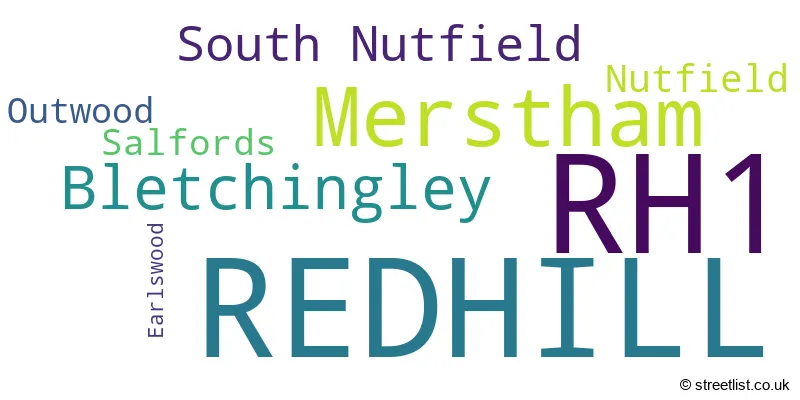
The largest settlement in the RH1 postal code is REDHILL followed by MERSTHAM, and BLETCHINGLEY.
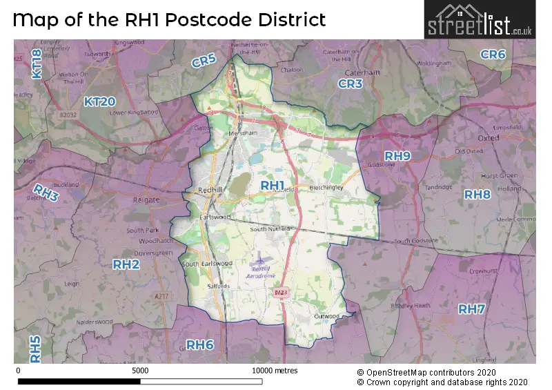
The RH1 Postcode shares a border with CR3 (CATERHAM, WHYTELEAFE), CR5 (COULSDON), RH2 (REIGATE, Leigh, Sidlow), RH6 (HORLEY, Smallfield, London Gatwick Airport) and RH9 (GODSTONE, South Godstone).
The primary settlement in the RH1 postcode district is Redhill, located in Surrey, England. Other significant settlements in the district include Merstham, Bletchingley, Nutfield, Outwood, Salfords, and Earlswood. The most significant post town in the district is Redhill.
For the district RH1, we have data on 7 postcode sectors. Here's a breakdown: The sector RH1 1, covers Redhill in Surrey. The sector RH1 2, covers Redhill in Surrey. The sector RH1 3, covers Merstham in Surrey. The sector RH1 4, covers Bletchingley and Redhill and Nutfield and South Nutfield in Surrey. The sector RH1 5, covers Redhill and South Nutfield and Salfords and Outwood in Surrey. The sector RH1 6, covers Redhill in Surrey. The sector RH1 9 is non-geographic. It's often designated for PO Boxes, large organisations, or special services.

Map of the RH1 Postcode District
Explore the RH1 postcode district by using our free interactive map.
When it comes to local government, postal geography often disregards political borders. However, for a breakdown in the RH1 District: the district mostly encompasses the Reigate and Banstead District (B) (1069 postcodes), and finally, the Tandridge District area (192 postcodes).
Recent House Sales in RH1
| Date | Price | Address |
|---|---|---|
| 02/10/2023 | £650,000 | Furze Place, Redhill, RH1 1ER |
| 29/09/2023 | £370,500 | Colman Way, Redhill, RH1 2BB |
| 29/09/2023 | £208,000 | Old School Close, Redhill, RH1 2FN |
| 28/09/2023 | £962,000 | Church Road, Redhill, RH1 6QA |
| 18/09/2023 | £460,000 | Prince Albert Square, Redhill, RH1 5AP |
| 15/09/2023 | £225,000 | Linkfield Lane, Redhill, RH1 1DU |
| 15/09/2023 | £430,000 | High Street, Merstham, Redhill, RH1 3BA |
| 15/09/2023 | £333,500 | Victoria Road, Redhill, RH1 6DX |
| 08/09/2023 | £1,080,000 | Gatton Park Road, Redhill, RH1 2EB |
| 07/09/2023 | £485,000 | Alpine Road, Redhill, RH1 2HY |
Weather Forecast for RH1
Press Button to Show Forecast for Redhill (Surrey)
| Time Period | Icon | Description | Temperature | Rain Probability | Wind |
|---|---|---|---|---|---|
| 12:00 to 15:00 | Overcast | 11.0°C (feels like 8.0°C) | 14.00% | WNW 9 mph | |
| 15:00 to 18:00 | Cloudy | 10.0°C (feels like 8.0°C) | 50.00% | WNW 9 mph | |
| 18:00 to 21:00 | Light rain | 8.0°C (feels like 7.0°C) | 75.00% | NW 7 mph | |
| 21:00 to 00:00 | Cloudy | 7.0°C (feels like 5.0°C) | 14.00% | NE 7 mph |
Press Button to Show Forecast for Redhill (Surrey)
| Time Period | Icon | Description | Temperature | Rain Probability | Wind |
|---|---|---|---|---|---|
| 00:00 to 03:00 | Cloudy | 6.0°C (feels like 4.0°C) | 9.00% | NE 7 mph | |
| 03:00 to 06:00 | Cloudy | 5.0°C (feels like 3.0°C) | 6.00% | NE 7 mph | |
| 06:00 to 09:00 | Cloudy | 5.0°C (feels like 2.0°C) | 7.00% | NE 7 mph | |
| 09:00 to 12:00 | Cloudy | 7.0°C (feels like 5.0°C) | 6.00% | ENE 9 mph | |
| 12:00 to 15:00 | Overcast | 10.0°C (feels like 8.0°C) | 14.00% | ENE 7 mph | |
| 15:00 to 18:00 | Overcast | 10.0°C (feels like 9.0°C) | 16.00% | ENE 7 mph | |
| 18:00 to 21:00 | Cloudy | 9.0°C (feels like 8.0°C) | 14.00% | ENE 7 mph | |
| 21:00 to 00:00 | Cloudy | 6.0°C (feels like 4.0°C) | 12.00% | E 7 mph |
Press Button to Show Forecast for Redhill (Surrey)
| Time Period | Icon | Description | Temperature | Rain Probability | Wind |
|---|---|---|---|---|---|
| 00:00 to 03:00 | Cloudy | 5.0°C (feels like 3.0°C) | 17.00% | E 7 mph | |
| 03:00 to 06:00 | Cloudy | 5.0°C (feels like 2.0°C) | 18.00% | ENE 7 mph | |
| 06:00 to 09:00 | Cloudy | 6.0°C (feels like 3.0°C) | 18.00% | ENE 9 mph | |
| 09:00 to 12:00 | Overcast | 9.0°C (feels like 7.0°C) | 19.00% | E 9 mph | |
| 12:00 to 15:00 | Overcast | 12.0°C (feels like 10.0°C) | 19.00% | E 9 mph | |
| 15:00 to 18:00 | Light rain | 11.0°C (feels like 9.0°C) | 52.00% | ENE 11 mph | |
| 18:00 to 21:00 | Light rain | 10.0°C (feels like 8.0°C) | 53.00% | ENE 11 mph | |
| 21:00 to 00:00 | Heavy rain | 9.0°C (feels like 7.0°C) | 75.00% | ENE 11 mph |
Press Button to Show Forecast for Redhill (Surrey)
| Time Period | Icon | Description | Temperature | Rain Probability | Wind |
|---|---|---|---|---|---|
| 00:00 to 03:00 | Heavy rain | 9.0°C (feels like 6.0°C) | 71.00% | NE 9 mph | |
| 03:00 to 06:00 | Heavy rain shower (night) | 9.0°C (feels like 7.0°C) | 60.00% | SE 11 mph | |
| 06:00 to 09:00 | Light rain | 9.0°C (feels like 7.0°C) | 48.00% | SE 9 mph | |
| 09:00 to 12:00 | Light rain shower (day) | 10.0°C (feels like 8.0°C) | 46.00% | SSE 11 mph | |
| 12:00 to 15:00 | Heavy rain shower (day) | 12.0°C (feels like 10.0°C) | 60.00% | S 11 mph | |
| 15:00 to 18:00 | Light rain shower (day) | 13.0°C (feels like 11.0°C) | 42.00% | SW 11 mph | |
| 18:00 to 21:00 | Light rain shower (day) | 11.0°C (feels like 9.0°C) | 34.00% | WSW 11 mph | |
| 21:00 to 00:00 | Partly cloudy (night) | 9.0°C (feels like 7.0°C) | 6.00% | SSW 7 mph |
Where is the RH1 Postcode District?
The RH1 postcode district is located in Redhill, a town in Surrey. It is situated near the towns of South Nutfield, Nutfield, and Bletchingley. Redhill is approximately 18.98 miles away from the center of London.
The district is within the post town of REDHILL.
The sector has postcodes within the nation of England.
The RH1 Postcode District is in the East Surrey region of Surrey, East and West Sussex within the South East (England).
Postcode Sectors within the RH1 District
- RH1 1
- RH1 2
- RH1 3
- RH1 4
- RH1 5
- RH1 6
- RH10 1
- RH10 3
- RH10 4
- RH10 5
- RH10 6
- RH10 7
- RH10 8
- RH10 9
- RH11 0
- RH11 6
- RH11 7
- RH11 8
- RH11 9
- RH12 1
- RH12 2
- RH12 3
- RH12 4
- RH12 5
- RH13 0
- RH13 5
- RH13 6
- RH13 8
- RH13 9
- RH14 0
- RH14 9
- RH15 0
- RH15 8
- RH15 9
- RH16 1
- RH16 2
- RH16 3
- RH16 4
- RH17 5
- RH17 6
- RH17 7
- RH18 5
- RH19 1
- RH19 2
- RH19 3
- RH19 4
| Postcode Sector | Delivery Office |
|---|---|
| RH1 1 | Redhill Delivery Office |
| RH1 2 | Redhill Delivery Office |
| RH1 3 | Redhill Delivery Office |
| RH1 4 | Redhill Delivery Office |
| RH1 5 | Redhill Delivery Office |
| RH1 6 | Redhill Delivery Office |
| R | H | 1 | - | X | X | X |
| R | H | 1 | Space | Numeric | Letter | Letter |
Current Monthly Rental Prices
| # Bedrooms | Min Price | Max Price | Avg Price |
|---|---|---|---|
| £825 | £875 | £856 | |
| 1 | £750 | £2,700 | £1,193 |
| 2 | £1,250 | £3,100 | £1,605 |
| 3 | £1,700 | £2,750 | £2,010 |
| 4 | £2,000 | £3,500 | £2,631 |
| 5 | £2,850 | £2,900 | £2,875 |
Current House Prices
| # Bedrooms | Min Price | Max Price | Avg Price |
|---|---|---|---|
| £135,000 | £800,000 | £376,667 | |
| 1 | £70,000 | £435,000 | £193,547 |
| 2 | £170,000 | £625,000 | £315,011 |
| 3 | £248,000 | £1,100,000 | £517,943 |
| 4 | £475,000 | £1,300,000 | £789,088 |
| 5 | £340,000 | £3,500,000 | £1,164,167 |
| 6 | £825,000 | £3,000,000 | £1,641,667 |
| 7 | £1,500,000 | £1,750,000 | £1,666,667 |
Estate Agents who Operate in the RH1 District
| Logo | Name | Brand Name | Address | Contact Number | Total Properties |
|---|---|---|---|---|---|
 | Redhill | Connells | 43 Station Road, Redhill, RH1 1QH | 01737 301547 | 72 |
 | Redhill | Cubitt & West | 5 Station Road Redhill Surrey, RH1 1NT | 01737 948417 | 27 |
 | Redhill - Sales | Woodlands Estate Agents | 49 Station Road, Redhill, RH1 1QH | 01737 301828 | 23 |
 | Redhill | Ralph James Estate Agents | 39 High Street, Redhill, RH1 1RX | 01737 302078 | 22 |
 | Redhill | Barnard Marcus | 27 Station Road, Redhill, RH1 1QH | 01737 949517 | 22 |
| Type of Property | 2018 Average | 2018 Sales | 2017 Average | 2017 Sales | 2016 Average | 2016 Sales | 2015 Average | 2015 Sales |
|---|---|---|---|---|---|---|---|---|
| Detached | £678,653 | 116 | £637,926 | 116 | £648,477 | 154 | £590,853 | 174 |
| Semi-Detached | £436,138 | 207 | £421,284 | 228 | £420,088 | 266 | £369,367 | 221 |
| Terraced | £388,017 | 180 | £382,578 | 174 | £364,947 | 198 | £326,092 | 238 |
| Flats | £231,654 | 255 | £236,375 | 309 | £235,205 | 358 | £213,716 | 439 |