The RH11 postcode district is a postal district located in the RH Redhill postcode area with a population of 60,281 residents according to the 2021 England and Wales Census.
The area of the RH11 postcode district is 12.19 square miles which is 31.56 square kilometres or 7,798.68 acres.
Currently, the RH11 district has about 1159 postcode units spread across 5 geographic postcode sectors.
Given that each sector allows for 400 unique postcode combinations, the district has a capacity of 2,000 postcodes. With 1159 postcodes already in use, this leaves 841 units available.
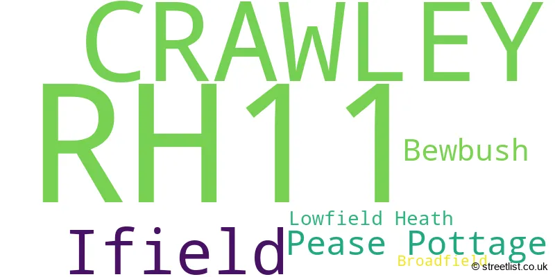
The largest settlement in the RH11 postal code is CRAWLEY followed by Ifield, and Pease Pottage.
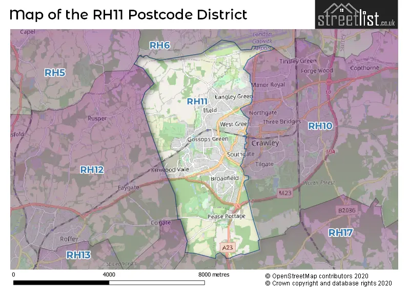
The RH11 Postcode shares a border with RH17 (Cuckfield, Balcombe, Ardingly), RH10 (CRAWLEY, Maidenbower, Copthorne) and RH6 (HORLEY, Smallfield, London Gatwick Airport).
The primary settlement in the RH11 postcode district is Crawley, located in the county of West Sussex, England. Other significant settlements include Ifield, Lowfield Heath, Bewbush, Broadfield, and Pease Pottage. The post town for this district is also Crawley.
For the district RH11, we have data on 5 postcode sectors. Here's a breakdown: The sector RH11 0, covers Ifield and Crawley in West Sussex. The sector RH11 6, covers Bewbush and Crawley in West Sussex. The sector RH11 7, covers Crawley in West Sussex. The sector RH11 8, covers Crawley in West Sussex. The sector RH11 9, covers Crawley and Pease Pottage in West Sussex.

Map of the RH11 Postcode District
Explore the RH11 postcode district by using our free interactive map.
When it comes to local government, postal geography often disregards political borders. However, for a breakdown in the RH11 District: the district mostly encompasses the Crawley District (B) (1085 postcodes), followed by the Mid Sussex District area (62 postcodes), and finally, the Horsham District area (34 postcodes).
Recent House Sales in RH11
| Date | Price | Address |
|---|---|---|
| 20/10/2023 | £96,000 | Oak Road, Crawley, RH11 8AE |
| 09/10/2023 | £322,500 | Norfolk Close, Crawley, RH11 8GJ |
| 08/09/2023 | £347,000 | Cherry Lane, Crawley, RH11 7NX |
| 07/09/2023 | £440,000 | Ewhurst Road, Crawley, RH11 7EX |
| 06/09/2023 | £551,000 | Town Barn Road, Crawley, RH11 7ED |
| 06/09/2023 | £435,950 | Fulham Close, Crawley, RH11 9NY |
| 06/09/2023 | £340,000 | St Brelades Road, Crawley, RH11 9RH |
| 04/09/2023 | £315,000 | Juniper Road, Crawley, RH11 7NL |
| 01/09/2023 | £325,000 | Medlar Close, Crawley, RH11 7SA |
| 31/08/2023 | £402,750 | Spartan Way, Crawley, RH11 7GH |
Weather Forecast for RH11
Press Button to Show Forecast for Crawley
| Time Period | Icon | Description | Temperature | Rain Probability | Wind |
|---|---|---|---|---|---|
| 18:00 to 21:00 | Cloudy | 9.0°C (feels like 7.0°C) | 50.00% | WNW 7 mph | |
| 21:00 to 00:00 | Light rain | 7.0°C (feels like 6.0°C) | 51.00% | N 7 mph |
Press Button to Show Forecast for Crawley
| Time Period | Icon | Description | Temperature | Rain Probability | Wind |
|---|---|---|---|---|---|
| 00:00 to 03:00 | Cloudy | 6.0°C (feels like 4.0°C) | 6.00% | ENE 7 mph | |
| 03:00 to 06:00 | Cloudy | 6.0°C (feels like 3.0°C) | 6.00% | ENE 7 mph | |
| 06:00 to 09:00 | Overcast | 5.0°C (feels like 3.0°C) | 10.00% | NE 7 mph | |
| 09:00 to 12:00 | Cloudy | 7.0°C (feels like 5.0°C) | 8.00% | ENE 9 mph | |
| 12:00 to 15:00 | Overcast | 9.0°C (feels like 8.0°C) | 15.00% | ENE 7 mph | |
| 15:00 to 18:00 | Overcast | 10.0°C (feels like 9.0°C) | 15.00% | ENE 7 mph | |
| 18:00 to 21:00 | Cloudy | 10.0°C (feels like 8.0°C) | 12.00% | E 7 mph | |
| 21:00 to 00:00 | Cloudy | 6.0°C (feels like 4.0°C) | 11.00% | E 7 mph |
Press Button to Show Forecast for Crawley
| Time Period | Icon | Description | Temperature | Rain Probability | Wind |
|---|---|---|---|---|---|
| 00:00 to 03:00 | Cloudy | 5.0°C (feels like 3.0°C) | 16.00% | ENE 7 mph | |
| 03:00 to 06:00 | Overcast | 5.0°C (feels like 2.0°C) | 22.00% | ENE 7 mph | |
| 06:00 to 09:00 | Cloudy | 6.0°C (feels like 4.0°C) | 18.00% | ENE 9 mph | |
| 09:00 to 12:00 | Overcast | 10.0°C (feels like 7.0°C) | 18.00% | E 11 mph | |
| 12:00 to 15:00 | Cloudy | 12.0°C (feels like 10.0°C) | 16.00% | E 11 mph | |
| 15:00 to 18:00 | Light rain | 12.0°C (feels like 9.0°C) | 49.00% | E 11 mph | |
| 18:00 to 21:00 | Light rain | 10.0°C (feels like 8.0°C) | 50.00% | ENE 11 mph | |
| 21:00 to 00:00 | Light rain | 9.0°C (feels like 7.0°C) | 51.00% | NE 11 mph |
Press Button to Show Forecast for Crawley
| Time Period | Icon | Description | Temperature | Rain Probability | Wind |
|---|---|---|---|---|---|
| 00:00 to 03:00 | Heavy rain | 9.0°C (feels like 7.0°C) | 73.00% | ENE 9 mph | |
| 03:00 to 06:00 | Heavy rain shower (night) | 9.0°C (feels like 7.0°C) | 59.00% | SE 11 mph | |
| 06:00 to 09:00 | Light rain | 9.0°C (feels like 7.0°C) | 48.00% | SE 9 mph | |
| 09:00 to 12:00 | Heavy rain shower (day) | 10.0°C (feels like 8.0°C) | 65.00% | SSE 11 mph | |
| 12:00 to 15:00 | Heavy rain shower (day) | 13.0°C (feels like 10.0°C) | 59.00% | SSW 13 mph | |
| 15:00 to 18:00 | Heavy rain shower (day) | 13.0°C (feels like 11.0°C) | 55.00% | SW 11 mph | |
| 18:00 to 21:00 | Light rain shower (day) | 11.0°C (feels like 9.0°C) | 33.00% | WSW 11 mph | |
| 21:00 to 00:00 | Cloudy | 9.0°C (feels like 8.0°C) | 10.00% | WSW 7 mph |
Where is the RH11 Postcode District?
The RH11 postcode district is located in Crawley. It is a district town in close proximity to several nearby towns. To the north is Horley, which is approximately 4.6 miles away. To the southwest is Horsham, which is around 5.8 miles away. East of Crawley is East Grinstead, situated approximately 8.8 miles away. Lastly, Haywards Heath is situated southeast of Crawley, at a distance of about 9 miles. Additionally, the RH11 postcode district is approximately 27.7 miles away from the centre of London.
The district is within the post town of CRAWLEY.
The sector has postcodes within the nation of England.
The RH11 Postcode District is in the West Sussex (North East) region of Surrey, East and West Sussex within the South East (England).
| Postcode Sector | Delivery Office |
|---|---|
| RH11 0 | Crawley Delivery Office |
| RH11 6 | Crawley Delivery Office |
| RH11 7 | Crawley Delivery Office |
| RH11 8 | Crawley Delivery Office |
| RH11 9 | Crawley Delivery Office |
| R | H | 1 | 1 | - | X | X | X |
| R | H | 1 | 1 | Space | Numeric | Letter | Letter |
Current Monthly Rental Prices
| # Bedrooms | Min Price | Max Price | Avg Price |
|---|---|---|---|
| £500 | £950 | £725 | |
| 1 | £550 | £1,175 | £886 |
| 2 | £1,200 | £1,500 | £1,300 |
| 3 | £1,450 | £1,750 | £1,563 |
| 4 | £1,600 | £2,800 | £2,117 |
| 6 | £2,800 | £2,800 | £2,800 |
Current House Prices
| # Bedrooms | Min Price | Max Price | Avg Price |
|---|---|---|---|
| £5,000 | £134,950 | £94,988 | |
| 1 | £75,000 | £295,000 | £184,201 |
| 2 | £100,000 | £450,000 | £276,281 |
| 3 | £215,000 | £900,000 | £381,977 |
| 4 | £300,000 | £1,035,000 | £573,350 |
| 5 | £450,000 | £1,250,000 | £757,500 |
| 6 | £650,000 | £1,200,000 | £925,000 |
| 7 | £850,000 | £850,000 | £850,000 |
Estate Agents who Operate in the RH11 District
| Logo | Name | Brand Name | Address | Contact Number | Total Properties |
|---|---|---|---|---|---|
 | Crawley | Cubitt & West | 2/3 Grand Parade, High Street, Crawley, RH10 1BU | 01293 222629 | 34 |
 | Crawley | Mansell McTaggart | 35 The Broadway, Crawley, West Sussex, RH10 1HD | 01293 222206 | 30 |
 | Crawley | Fox & Sons | 34 High Street, Crawley, West Sussex, RH10 1BW | 01293 222568 | 23 |
 | Crawley | Taylor Robinson | 2 Brittingham House, Orchard Street, Crawley, RH11 7AE | 01293 552388 | 22 |
 | Crawley | Homes Partnership | 44 High Street, Crawley, Sussex, RH10 1BW | 01293 529999 | 19 |
| Type of Property | 2018 Average | 2018 Sales | 2017 Average | 2017 Sales | 2016 Average | 2016 Sales | 2015 Average | 2015 Sales |
|---|---|---|---|---|---|---|---|---|
| Detached | £503,716 | 66 | £489,213 | 98 | £464,844 | 61 | £457,678 | 73 |
| Semi-Detached | £342,802 | 152 | £345,600 | 178 | £320,049 | 119 | £283,981 | 133 |
| Terraced | £278,744 | 362 | £274,973 | 370 | £261,763 | 407 | £234,933 | 477 |
| Flats | £209,496 | 347 | £198,929 | 176 | £190,200 | 200 | £161,625 | 145 |