The RH13 postcode district is a postal district located in the RH Redhill postcode area with a population of 40,063 residents according to the 2021 England and Wales Census.
The area of the RH13 postcode district is 65.31 square miles which is 169.16 square kilometres or 41,799.09 acres.
Currently, the RH13 district has about 1107 postcode units spread across 5 geographic postcode sectors.
Given that each sector allows for 400 unique postcode combinations, the district has a capacity of 2,000 postcodes. With 1107 postcodes already in use, this leaves 893 units available.
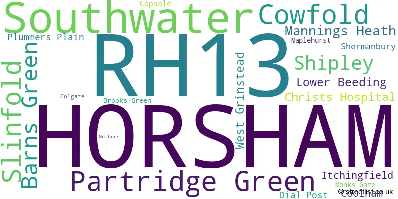
The largest settlement in the RH13 postal code is HORSHAM followed by Southwater, and Partridge Green.
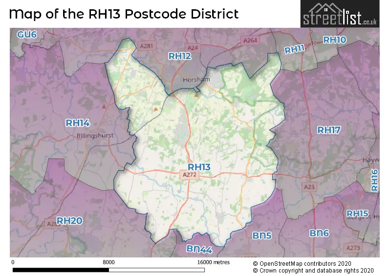
The RH13 Postcode shares a border with RH17 (Cuckfield, Balcombe, Ardingly), BN5 (HENFIELD, Small Dole, Woodmancote), RH14 (BILLINGSHURST, Loxwood, Wisborough Green), BN44 (STEYNING, Upper Beeding, Bramber), RH20 (Storrington, PULBOROUGH, West Chiltington) and RH12 (HORSHAM, Broadbridge Heath, Faygate).
The primary settlement in the RH13 postcode district is Horsham, located in West Sussex, England. Other significant settlements in this district include Barns Green, Brooks Green, Christs Hospital, Itchingfield, Slinfold, Colgate, Copsale, Lower Beeding, Mannings Heath, Maplehurst, Monks Gate, Nuthurst, Plummers Plain, Coolham, Cowfold, Dial Post, Partridge Green, Shermanbury, Shipley, and Southwater. The most significant post town in this district is Horsham.
For the district RH13, we have data on 5 postcode sectors. Here's a breakdown: The sector RH13 0, covers Slinfold and Barns Green and Christs Hospital and Horsham in West Sussex. The sector RH13 5, covers Horsham in West Sussex. The sector RH13 6, covers Horsham and Mannings Heath and Lower Beeding in West Sussex. The sector RH13 8, covers Partridge Green and Cowfold and Shipley in West Sussex. The sector RH13 9, covers Southwater in West Sussex.

Map of the RH13 Postcode District
Explore the RH13 postcode district by using our free interactive map.
When it comes to local government, postal geography often disregards political borders. However, for a breakdown in the RH13 District: the district mostly encompasses the Horsham District area with a total of 1121 postcodes.
Recent House Sales in RH13
| Date | Price | Address |
|---|---|---|
| 25/10/2023 | £415,000 | Lyons Road, Slinfold, Horsham, RH13 0QT |
| 18/10/2023 | £375,000 | Little Oak, Partridge Green, Horsham, RH13 8JY |
| 17/10/2023 | £350,000 | Cambria Close, Partridge Green, Horsham, RH13 8GW |
| 06/10/2023 | £300,000 | Coach House Mews, Cowfold, Horsham, RH13 8BU |
| 04/10/2023 | £586,000 | Chesworth Crescent, Horsham, RH13 5AN |
| 29/09/2023 | £210,000 | Woodhatch, Southwater, Horsham, RH13 9TU |
| 29/09/2023 | £570,000 | Brighton Road, Shermanbury, Horsham, RH13 8HB |
| 28/09/2023 | £395,000 | Bluecoat Pond, Christs Hospital, Horsham, RH13 0NW |
| 22/09/2023 | £275,000 | Ayshe Court Drive, Horsham, RH13 5RL |
| 20/09/2023 | £445,000 | Bluecoat Pond, Christs Hospital, Horsham, RH13 0NW |
Weather Forecast for RH13
Press Button to Show Forecast for West Grinstead
| Time Period | Icon | Description | Temperature | Rain Probability | Wind |
|---|---|---|---|---|---|
| 09:00 to 12:00 | Overcast | 12.0°C (feels like 9.0°C) | 11.00% | NW 16 mph | |
| 12:00 to 15:00 | Cloudy | 13.0°C (feels like 10.0°C) | 8.00% | NW 16 mph | |
| 15:00 to 18:00 | Cloudy | 13.0°C (feels like 10.0°C) | 7.00% | NNW 16 mph | |
| 18:00 to 21:00 | Cloudy | 11.0°C (feels like 9.0°C) | 7.00% | N 9 mph | |
| 21:00 to 00:00 | Cloudy | 8.0°C (feels like 6.0°C) | 5.00% | NNE 7 mph |
Press Button to Show Forecast for West Grinstead
| Time Period | Icon | Description | Temperature | Rain Probability | Wind |
|---|---|---|---|---|---|
| 00:00 to 03:00 | Partly cloudy (night) | 6.0°C (feels like 3.0°C) | 1.00% | N 7 mph | |
| 03:00 to 06:00 | Clear night | 5.0°C (feels like 2.0°C) | 1.00% | NNW 9 mph | |
| 06:00 to 09:00 | Sunny day | 5.0°C (feels like 2.0°C) | 1.00% | NNW 9 mph | |
| 09:00 to 12:00 | Overcast | 8.0°C (feels like 5.0°C) | 7.00% | N 11 mph | |
| 12:00 to 15:00 | Overcast | 10.0°C (feels like 7.0°C) | 9.00% | N 11 mph | |
| 15:00 to 18:00 | Overcast | 11.0°C (feels like 8.0°C) | 8.00% | N 11 mph | |
| 18:00 to 21:00 | Overcast | 10.0°C (feels like 8.0°C) | 9.00% | N 9 mph | |
| 21:00 to 00:00 | Cloudy | 7.0°C (feels like 5.0°C) | 5.00% | NNE 7 mph |
Press Button to Show Forecast for West Grinstead
| Time Period | Icon | Description | Temperature | Rain Probability | Wind |
|---|---|---|---|---|---|
| 00:00 to 03:00 | Cloudy | 5.0°C (feels like 4.0°C) | 5.00% | NNE 4 mph | |
| 03:00 to 06:00 | Partly cloudy (night) | 5.0°C (feels like 3.0°C) | 2.00% | N 4 mph | |
| 06:00 to 09:00 | Partly cloudy (day) | 5.0°C (feels like 3.0°C) | 2.00% | N 7 mph | |
| 09:00 to 12:00 | Cloudy | 9.0°C (feels like 6.0°C) | 6.00% | NNE 9 mph | |
| 12:00 to 15:00 | Overcast | 10.0°C (feels like 8.0°C) | 9.00% | NNE 11 mph | |
| 15:00 to 18:00 | Overcast | 11.0°C (feels like 9.0°C) | 11.00% | NNE 11 mph | |
| 18:00 to 21:00 | Cloudy | 10.0°C (feels like 8.0°C) | 9.00% | NNE 9 mph | |
| 21:00 to 00:00 | Clear night | 8.0°C (feels like 5.0°C) | 2.00% | NE 9 mph |
Press Button to Show Forecast for West Grinstead
| Time Period | Icon | Description | Temperature | Rain Probability | Wind |
|---|---|---|---|---|---|
| 00:00 to 03:00 | Clear night | 6.0°C (feels like 3.0°C) | 4.00% | NNE 9 mph | |
| 03:00 to 06:00 | Clear night | 5.0°C (feels like 2.0°C) | 3.00% | NNE 9 mph | |
| 06:00 to 09:00 | Sunny day | 5.0°C (feels like 2.0°C) | 3.00% | NNE 9 mph | |
| 09:00 to 12:00 | Partly cloudy (day) | 9.0°C (feels like 7.0°C) | 2.00% | NE 11 mph | |
| 12:00 to 15:00 | Cloudy | 11.0°C (feels like 8.0°C) | 7.00% | NE 11 mph | |
| 15:00 to 18:00 | Cloudy | 11.0°C (feels like 9.0°C) | 7.00% | NE 11 mph | |
| 18:00 to 21:00 | Cloudy | 10.0°C (feels like 7.0°C) | 7.00% | NE 11 mph | |
| 21:00 to 00:00 | Partly cloudy (night) | 7.0°C (feels like 5.0°C) | 2.00% | NE 9 mph |
Where is the RH13 Postcode District?
The postcode district RH13 is located in the town of Horsham. It is situated near several nearby towns, including Billingshurst in the West (5.15 miles away), Henfield in the South East (6.19 miles away), Steyning in the South (7.70 miles away), Pulborough in the South West (7.78 miles away), Burgess Hill in the East (9.61 miles away), Crawley in the North East (9.73 miles away), and Cranleigh in the North West (11.15 miles away). Additionally, the district is approximately 35.28 miles away from the center of London.
The district is within the post town of HORSHAM.
The sector has postcodes within the nation of England.
The RH13 Postcode District is in the West Sussex (North East) region of Surrey, East and West Sussex within the South East (England).
| Postcode Sector | Delivery Office |
|---|---|
| RH13 0 | Horsham Delivery Office |
| RH13 5 | Horsham Delivery Office |
| RH13 6 | Horsham Delivery Office |
| RH13 8 | Horsham Delivery Office |
| RH13 9 | Horsham Delivery Office |
| R | H | 1 | 3 | - | X | X | X |
| R | H | 1 | 3 | Space | Numeric | Letter | Letter |
Tourist Attractions within the Postcode Area
We found 1 visitor attractions within the RH13 postcode area
| Southwater Country Park |
|---|
| Country Parks |
| Country Park |
| View Southwater Country Park on Google Maps |
Current Monthly Rental Prices
| # Bedrooms | Min Price | Max Price | Avg Price |
|---|---|---|---|
| £750 | £4,853 | £2,134 | |
| 1 | £1,050 | £1,350 | £1,200 |
| 2 | £1,000 | £5,824 | £1,725 |
| 3 | £1,295 | £3,000 | £1,819 |
| 4 | £2,000 | £2,000 | £2,000 |
| 5 | £16,987 | £16,987 | £16,987 |
Current House Prices
| # Bedrooms | Min Price | Max Price | Avg Price |
|---|---|---|---|
| £200,000 | £2,235,000 | £728,500 | |
| 1 | £90,000 | £305,000 | £211,466 |
| 2 | £64,995 | £765,000 | £321,547 |
| 3 | £248,000 | £1,100,000 | £525,100 |
| 4 | £280,500 | £1,950,000 | £758,334 |
| 5 | £575,000 | £3,950,000 | £1,198,696 |
| 6 | £850,000 | £1,975,000 | £1,655,000 |
| 8 | £4,500,000 | £4,500,000 | £4,500,000 |
| 10 | £3,950,000 | £6,500,000 | £5,650,000 |
| 12 | £7,950,000 | £7,950,000 | £7,950,000 |
| 15 | £3,950,000 | £3,950,000 | £3,950,000 |
Estate Agents who Operate in the RH13 District
| Logo | Name | Brand Name | Address | Contact Number | Total Properties |
|---|---|---|---|---|---|
 | Horsham | At Home Estate and Lettings Agency | 35 Carfax Horsham RH12 1EE | 01405 800347 | 26 |
 | Southwater | Cubitt & West | 7/8 Lintot Square, Fairbank Road, Southwater, West Sussex, RH13 9LA | 01403 332206 | 26 |
 | Worthing | Homewise | 1 Liverpool Gardens Worthing BN11 1TF | 01903 497338 | 18 |
 | Horsham | Brock Taylor | 2 East Street Horsham RH12 1HL | 01403 912643 | 18 |
 | Horsham | Courtney Green | 25 Carfax, Horsham, RH12 1EE | 01403 252200 | 17 |
- Barns Green
- Broadbridge Heath
- Brooks Green
- Broomer's Corner
- Colgate
- Coneyhurst
- Coolham
- Copsale
- Cowfold
- Crabtree
- Dial Post
- Dragons Green
- Five Oaks
- Henfield
- Horsham
- Itchingfield
- Kent Street
- Littleworth
- Lower Beeding
- Mannings Heath
- Maplehurst
- Monk's Gate
- Nuthurst
- Partridge Green
- Plummers Plain
- Shermanbury
- Shipley
- Slinfold
- Southwater
- Tower Hill
- West Grinstead
- Whitehall
| Type of Property | 2018 Average | 2018 Sales | 2017 Average | 2017 Sales | 2016 Average | 2016 Sales | 2015 Average | 2015 Sales |
|---|---|---|---|---|---|---|---|---|
| Detached | £608,699 | 242 | £630,695 | 196 | £600,732 | 205 | £555,832 | 249 |
| Semi-Detached | £391,469 | 184 | £394,081 | 141 | £387,461 | 132 | £343,432 | 145 |
| Terraced | £348,908 | 96 | £318,738 | 121 | £314,772 | 117 | £298,431 | 139 |
| Flats | £209,830 | 119 | £222,060 | 189 | £209,654 | 251 | £199,312 | 147 |
Hotels within the Postcode Area
We found 5 hotels and guest houses within the RH13 postcode area
South Lodge, an Exclusive Hotel
Brighton Road, Lower Beeding, Horsham, lower-beeding, RH13 6PS.
View detailsThe Windmill Inn
The Windmill Inn, Littleworth Lane, West Grinstead, Horsham, horsham, RH13 8EJ.
View details