The RH18 postcode district is a postal district located in the RH Redhill postcode area with a population of 4,476 residents according to the 2021 England and Wales Census.
The area of the RH18 postcode district is 7.47 square miles which is 19.35 square kilometres or 4,782.39 acres.
Currently, the RH18 district has about 143 postcode units spread across 1 geographic postcode sectors.
Given that each sector allows for 400 unique postcode combinations, the district has a capacity of 400 postcodes. With 143 postcodes already in use, this leaves 257 units available.
The largest settlement in the RH18 postal code is FOREST ROW followed by Wych Cross, and Weir Wood.
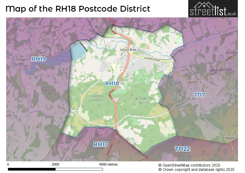
The RH18 Postcode shares a border with TN7 (HARTFIELD, Withyham, Upper Hartfield), RH19 (EAST GRINSTEAD, Felbridge, Ashurst Wood), TN22 (UCKFIELD, Ridgewood, Buxted) and RH17 (Cuckfield, Balcombe, Ardingly).
The primary settlement in the RH18 postcode district is Forest Row, located in the county of East Sussex. Other significant settlements in this district include Weir Wood and Wych Cross, which are also located in East Sussex. The most significant post town in the district is Forest Row.
For the district RH18, we have data on 1 postcode sectors. Here's a breakdown: The sector RH18 5, covers Forest Row in East Sussex.
RH18 Postcode Sectors

Map of the RH18 Postcode District
Explore the RH18 postcode district by using our free interactive map.
When it comes to local government, postal geography often disregards political borders. However, for a breakdown in the RH18 District: the district mostly encompasses the Wealden District area with a total of 141 postcodes.
Recent House Sales in RH18
| Date | Price | Address |
|---|---|---|
| 16/10/2023 | £540,000 | Woodcote Road, Forest Row, RH18 5AP |
| 14/09/2023 | £2,250,000 | Wych Cross, Forest Row, RH18 5JN |
| 31/08/2023 | £445,000 | Ashdown Close, Forest Row, RH18 5DF |
| 31/08/2023 | £450,000 | Hartfield Road, Forest Row, RH18 5FU |
| 31/08/2023 | £240,000 | Hartfield Road, Forest Row, RH18 5FU |
| 09/08/2023 | £615,000 | Park Crescent, Forest Row, RH18 5ED |
| 07/08/2023 | £135,000 | Hartfield Road, Forest Row, RH18 5DZ |
| 14/07/2023 | £870,000 | Lewes Road, Forest Row, RH18 5AN |
| 03/07/2023 | £470,000 | Hartfield Road, Forest Row, RH18 5BZ |
| 16/06/2023 | £975,000 | Tompsets Bank, Forest Row, RH18 5BG |
Weather Forecast for RH18
Press Button to Show Forecast for Standen
| Time Period | Icon | Description | Temperature | Rain Probability | Wind |
|---|---|---|---|---|---|
| 12:00 to 15:00 | Cloudy | 10.0°C (feels like 8.0°C) | 12.00% | WNW 9 mph | |
| 15:00 to 18:00 | Cloudy | 10.0°C (feels like 8.0°C) | 53.00% | W 11 mph | |
| 18:00 to 21:00 | Light rain | 9.0°C (feels like 7.0°C) | 53.00% | WNW 7 mph | |
| 21:00 to 00:00 | Light rain | 7.0°C (feels like 5.0°C) | 51.00% | N 4 mph |
Press Button to Show Forecast for Standen
| Time Period | Icon | Description | Temperature | Rain Probability | Wind |
|---|---|---|---|---|---|
| 00:00 to 03:00 | Cloudy | 6.0°C (feels like 4.0°C) | 7.00% | NE 4 mph | |
| 03:00 to 06:00 | Cloudy | 5.0°C (feels like 3.0°C) | 6.00% | NE 7 mph | |
| 06:00 to 09:00 | Overcast | 5.0°C (feels like 2.0°C) | 10.00% | NE 9 mph | |
| 09:00 to 12:00 | Cloudy | 7.0°C (feels like 4.0°C) | 8.00% | ENE 9 mph | |
| 12:00 to 15:00 | Overcast | 9.0°C (feels like 7.0°C) | 15.00% | ENE 7 mph | |
| 15:00 to 18:00 | Overcast | 10.0°C (feels like 8.0°C) | 15.00% | E 7 mph | |
| 18:00 to 21:00 | Cloudy | 9.0°C (feels like 7.0°C) | 12.00% | E 7 mph | |
| 21:00 to 00:00 | Cloudy | 6.0°C (feels like 4.0°C) | 11.00% | E 7 mph |
Press Button to Show Forecast for Standen
| Time Period | Icon | Description | Temperature | Rain Probability | Wind |
|---|---|---|---|---|---|
| 00:00 to 03:00 | Cloudy | 5.0°C (feels like 2.0°C) | 16.00% | ENE 7 mph | |
| 03:00 to 06:00 | Overcast | 5.0°C (feels like 2.0°C) | 22.00% | ENE 7 mph | |
| 06:00 to 09:00 | Overcast | 6.0°C (feels like 4.0°C) | 20.00% | ENE 9 mph | |
| 09:00 to 12:00 | Overcast | 10.0°C (feels like 8.0°C) | 17.00% | E 11 mph | |
| 12:00 to 15:00 | Cloudy | 12.0°C (feels like 10.0°C) | 19.00% | E 11 mph | |
| 15:00 to 18:00 | Light rain | 11.0°C (feels like 9.0°C) | 50.00% | E 11 mph | |
| 18:00 to 21:00 | Light rain | 10.0°C (feels like 7.0°C) | 54.00% | ENE 11 mph | |
| 21:00 to 00:00 | Light rain | 9.0°C (feels like 7.0°C) | 51.00% | NE 11 mph |
Press Button to Show Forecast for Standen
| Time Period | Icon | Description | Temperature | Rain Probability | Wind |
|---|---|---|---|---|---|
| 00:00 to 03:00 | Heavy rain | 9.0°C (feels like 7.0°C) | 76.00% | ENE 9 mph | |
| 03:00 to 06:00 | Heavy rain shower (night) | 9.0°C (feels like 7.0°C) | 58.00% | SE 11 mph | |
| 06:00 to 09:00 | Light rain | 9.0°C (feels like 7.0°C) | 48.00% | SE 9 mph | |
| 09:00 to 12:00 | Light rain shower (day) | 10.0°C (feels like 8.0°C) | 46.00% | SSE 13 mph | |
| 12:00 to 15:00 | Heavy rain shower (day) | 12.0°C (feels like 10.0°C) | 60.00% | SSW 13 mph | |
| 15:00 to 18:00 | Light rain shower (day) | 13.0°C (feels like 10.0°C) | 38.00% | SW 13 mph | |
| 18:00 to 21:00 | Light rain shower (day) | 11.0°C (feels like 9.0°C) | 35.00% | WSW 11 mph | |
| 21:00 to 00:00 | Partly cloudy (night) | 9.0°C (feels like 7.0°C) | 7.00% | SW 7 mph |
Where is the RH18 Postcode District?
The RH18 postcode district is located in Forest Row, a town in the southeast of England. Forest Row is surrounded by several nearby towns, including East Grinstead to the northwest, Hartfield to the northeast, Crowborough to the east, Lingfield to the north, Haywards Heath to the southwest, and Uckfield to the southeast. Additionally, Forest Row is situated approximately 29.97 miles away from the center of London.
The district is within the post town of FOREST ROW.
The sector has postcodes within the nation of England.
The RH18 Postcode District is covers the following regions.
- East Sussex CC - Surrey, East and West Sussex - South East (England)
- West Sussex (North East) - Surrey, East and West Sussex - South East (England)
Postcode Sectors within the RH18 District
| Postcode Sector | Delivery Office |
|---|---|
| RH18 5 | East Grinstead Delivery Office |
| R | H | 1 | 8 | - | X | X | X |
| R | H | 1 | 8 | Space | Numeric | Letter | Letter |
Current Monthly Rental Prices
| # Bedrooms | Min Price | Max Price | Avg Price |
|---|---|---|---|
| 2 | £2,000 | £2,000 | £2,000 |
| 4 | £2,500 | £4,500 | £3,500 |
Current House Prices
| # Bedrooms | Min Price | Max Price | Avg Price |
|---|---|---|---|
| £40,000 | £40,000 | £40,000 | |
| 1 | £85,000 | £160,000 | £122,500 |
| 2 | £125,000 | £500,000 | £245,909 |
| 3 | £250,000 | £800,000 | £511,364 |
| 4 | £575,000 | £1,250,000 | £965,625 |
| 5 | £700,000 | £2,250,000 | £1,416,667 |
| 6 | £1,600,000 | £1,600,000 | £1,600,000 |
Estate Agents who Operate in the RH18 District
| Logo | Name | Brand Name | Address | Contact Number | Total Properties |
|---|---|---|---|---|---|
 | Forest Row | Mansell McTaggart | The Old Bakery The Square Forest Row East Sussex RH18 5ES | 01342 645308 | 19 |
 | South East | Yopa | Meridian House Wheatfield Way Hinckley LE10 1YG | 01322 952994 | 3 |
 | Forest Row | Humberts | Humberts, The Old Bakery, Lewes Road, Forest Row, East Sussex, RH18 5HA | 01342 651090 | 3 |
 | East Grinstead | Cole's Estate Agents | 56 High Street East Grinstead West Sussex RH19 3DE | 01342 645077 | 3 |
 | Forest Row | KMJ Property | 5 Hartfield Road, Forest Row, RH18 5DN | 01342 645373 | 3 |
| Type of Property | 2018 Average | 2018 Sales | 2017 Average | 2017 Sales | 2016 Average | 2016 Sales | 2015 Average | 2015 Sales |
|---|---|---|---|---|---|---|---|---|
| Detached | £758,131 | 21 | £750,043 | 22 | £752,640 | 34 | £635,387 | 31 |
| Semi-Detached | £409,786 | 7 | £409,615 | 13 | £402,930 | 15 | £325,920 | 13 |
| Terraced | £354,188 | 16 | £393,493 | 7 | £352,727 | 11 | £403,542 | 21 |
| Flats | £279,438 | 8 | £272,656 | 16 | £233,118 | 17 | £223,400 | 15 |