The RH5 postcode district is a postal district located in the RH Redhill postcode area with a population of 16,249 residents according to the 2021 England and Wales Census.
The area of the RH5 postcode district is 56.16 square miles which is 145.46 square kilometres or 35,944.65 acres.
Currently, the RH5 district has about 639 postcode units spread across 3 geographic postcode sectors.
Given that each sector allows for 400 unique postcode combinations, the district has a capacity of 1,200 postcodes. With 639 postcodes already in use, this leaves 561 units available.
The largest settlement in the RH5 postal code is Newdigate followed by Beare Green, and North Holmwood.
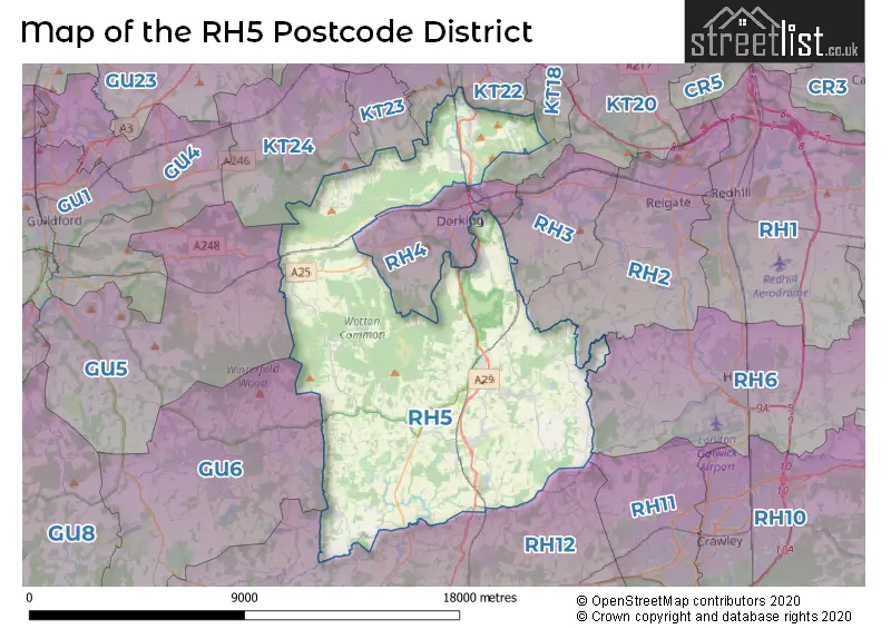
The RH5 Postcode shares a border with GU6 (CRANLEIGH, Ewhurst, Alfold), KT20 (TADWORTH, KINGSWOOD, LOWER KINGSWOOD), RH12 (HORSHAM, Broadbridge Heath, Faygate), KT22 (LEATHERHEAD, FETCHAM, Oxshott), KT23 (Great Bookham, BOOKHAM, Little Bookham), KT24 (East Horsley, West Horsley, Effingham), RH2 (REIGATE, Leigh, Sidlow), RH3 (Brockham, BETCHWORTH, BUCKLAND), RH4 (DORKING, Westcott, Pixham) and RH6 (HORLEY, Smallfield, London Gatwick Airport).
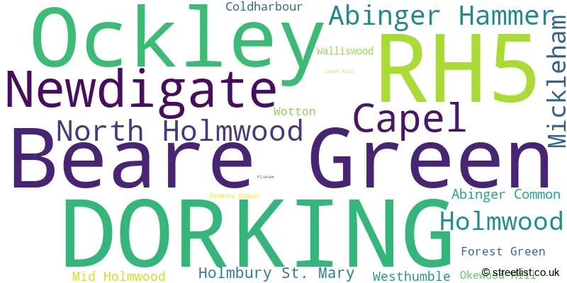
In the RH5 postcode district, the primary settlement is Dorking, which is located in the county of Surrey, England. Other significant settlements in this district include Beare Green, Coldharbour, Holmwood, Mid Holmwood, North Holmwood, Capel, Forest Green, Newdigate, Ockley, Okewood Hill, Walliswood, Abinger Common, Abinger Hammer, Holmbury St. Mary, Mickleham, Ranmore Common, Westhumble, and Wotton. The most significant postal town in this district is Dorking.
For the district RH5, we have data on 3 postcode sectors. Here's a breakdown: The sector RH5 4, covers Dorking and Beare Green and North Holmwood and Holmwood in Surrey. The sector RH5 5, covers Ockley and Newdigate and Capel in Surrey. The sector RH5 6, covers Abinger Hammer and Mickleham and Holmbury St. Mary and Abinger Common and Westhumble in Surrey.

Map of the RH5 Postcode District
Explore the RH5 postcode district by using our free interactive map.
When it comes to local government, postal geography often disregards political borders. However, for a breakdown in the RH5 District: the district mostly encompasses the Mole Valley District (599 postcodes), followed by the Guildford District (B) area (39 postcodes), and finally, the Waverley District (B) area (4 postcodes).
Recent House Sales in RH5
| Date | Price | Address |
|---|---|---|
| 17/10/2023 | £362,500 | Treelands, North Holmwood, Dorking, RH5 4TE |
| 06/10/2023 | £295,000 | Leith View, North Holmwood, Dorking, RH5 4TG |
| 12/09/2023 | £720,000 | Village Street, Newdigate, Dorking, RH5 5DH |
| 08/09/2023 | £281,500 | Wildcroft Drive, North Holmwood, Dorking, RH5 4TL |
| 01/09/2023 | £420,000 | Chart Downs, Dorking, RH5 4DF |
| 29/08/2023 | £690,000 | Wildcroft Drive, North Holmwood, Dorking, RH5 4TX |
| 25/08/2023 | £510,000 | Overdale, Dorking, RH5 4BS |
| 24/08/2023 | £460,000 | Devon Gate, Holmwood, Dorking, RH5 4NG |
| 23/08/2023 | £520,000 | Church Terrace, Holmwood, Dorking, RH5 4JZ |
| 18/08/2023 | £600,000 | Felday Road, Abinger Hammer, Dorking, RH5 6QX |
Weather Forecast for RH5
Press Button to Show Forecast for Capel
| Time Period | Icon | Description | Temperature | Rain Probability | Wind |
|---|---|---|---|---|---|
| 09:00 to 12:00 | Partly cloudy (day) | 9.0°C (feels like 7.0°C) | 3.00% | W 9 mph | |
| 12:00 to 15:00 | Overcast | 11.0°C (feels like 8.0°C) | 14.00% | WNW 9 mph | |
| 15:00 to 18:00 | Light rain | 10.0°C (feels like 7.0°C) | 53.00% | W 9 mph | |
| 18:00 to 21:00 | Light rain | 8.0°C (feels like 7.0°C) | 51.00% | NW 4 mph | |
| 21:00 to 00:00 | Cloudy | 7.0°C (feels like 5.0°C) | 52.00% | NE 4 mph |
Press Button to Show Forecast for Capel
| Time Period | Icon | Description | Temperature | Rain Probability | Wind |
|---|---|---|---|---|---|
| 00:00 to 03:00 | Cloudy | 6.0°C (feels like 4.0°C) | 11.00% | NE 7 mph | |
| 03:00 to 06:00 | Cloudy | 5.0°C (feels like 2.0°C) | 6.00% | NE 7 mph | |
| 06:00 to 09:00 | Cloudy | 5.0°C (feels like 2.0°C) | 7.00% | NE 7 mph | |
| 09:00 to 12:00 | Cloudy | 7.0°C (feels like 4.0°C) | 9.00% | ENE 9 mph | |
| 12:00 to 15:00 | Overcast | 9.0°C (feels like 8.0°C) | 17.00% | ENE 7 mph | |
| 15:00 to 18:00 | Overcast | 10.0°C (feels like 9.0°C) | 15.00% | ENE 7 mph | |
| 18:00 to 21:00 | Cloudy | 9.0°C (feels like 8.0°C) | 12.00% | E 7 mph | |
| 21:00 to 00:00 | Cloudy | 6.0°C (feels like 4.0°C) | 11.00% | E 7 mph |
Press Button to Show Forecast for Capel
| Time Period | Icon | Description | Temperature | Rain Probability | Wind |
|---|---|---|---|---|---|
| 00:00 to 03:00 | Cloudy | 5.0°C (feels like 2.0°C) | 18.00% | E 7 mph | |
| 03:00 to 06:00 | Overcast | 4.0°C (feels like 2.0°C) | 24.00% | ENE 7 mph | |
| 06:00 to 09:00 | Cloudy | 5.0°C (feels like 3.0°C) | 18.00% | ENE 9 mph | |
| 09:00 to 12:00 | Overcast | 9.0°C (feels like 7.0°C) | 19.00% | E 9 mph | |
| 12:00 to 15:00 | Overcast | 12.0°C (feels like 9.0°C) | 20.00% | E 9 mph | |
| 15:00 to 18:00 | Light rain | 11.0°C (feels like 9.0°C) | 50.00% | ENE 11 mph | |
| 18:00 to 21:00 | Light rain | 10.0°C (feels like 7.0°C) | 50.00% | ENE 11 mph | |
| 21:00 to 00:00 | Heavy rain | 9.0°C (feels like 6.0°C) | 74.00% | NE 11 mph |
Press Button to Show Forecast for Capel
| Time Period | Icon | Description | Temperature | Rain Probability | Wind |
|---|---|---|---|---|---|
| 00:00 to 03:00 | Heavy rain | 8.0°C (feels like 6.0°C) | 71.00% | NE 11 mph | |
| 03:00 to 06:00 | Heavy rain shower (night) | 9.0°C (feels like 7.0°C) | 61.00% | SE 11 mph | |
| 06:00 to 09:00 | Light rain | 9.0°C (feels like 7.0°C) | 47.00% | SE 9 mph | |
| 09:00 to 12:00 | Heavy rain shower (day) | 10.0°C (feels like 8.0°C) | 59.00% | SSE 11 mph | |
| 12:00 to 15:00 | Heavy rain shower (day) | 12.0°C (feels like 10.0°C) | 61.00% | SSW 11 mph | |
| 15:00 to 18:00 | Light rain shower (day) | 13.0°C (feels like 10.0°C) | 40.00% | SW 11 mph | |
| 18:00 to 21:00 | Cloudy | 11.0°C (feels like 9.0°C) | 14.00% | WSW 11 mph | |
| 21:00 to 00:00 | Cloudy | 8.0°C (feels like 7.0°C) | 8.00% | WSW 7 mph |
Where is the RH5 Postcode District?
The RH5 postcode district is located in Dorking. Dorking is a district town that is nearby several other towns. To the northeast is Betchworth, which is approximately 4.53 miles away. To the southwest is Cranleigh, which is around 7.05 miles away. To the north is Fetcham, which is roughly 7.13 miles away. To the east is Horley, which is approximately 7.63 miles away. In addition to these nearby towns, the RH5 district is also located about 24.33 miles away from the center of London.
The district is within the post town of DORKING.
The sector has postcodes within the nation of England.
The RH5 Postcode District is covers the following regions.
- East Surrey - Surrey, East and West Sussex - South East (England)
- West Sussex (North East) - Surrey, East and West Sussex - South East (England)
- West Surrey - Surrey, East and West Sussex - South East (England)
| Postcode Sector | Delivery Office |
|---|---|
| RH5 4 | Dorking Delivery Office |
| RH5 5 | Dorking Delivery Office |
| RH5 6 | Dorking Delivery Office |
| R | H | 5 | - | X | X | X |
| R | H | 5 | Space | Numeric | Letter | Letter |
Tourist Attractions within the Postcode Area
We found 2 visitor attractions within the RH5 postcode area
| Leith Hill Place |
|---|
| Historic Properties |
| Historic House / House and Garden / Palace |
| View Leith Hill Place on Google Maps |
| Polesden Lacey |
| Historic Properties |
| Historic House / House and Garden / Palace |
| View Polesden Lacey on Google Maps |
Current Monthly Rental Prices
| # Bedrooms | Min Price | Max Price | Avg Price |
|---|---|---|---|
| £392 | £725 | £559 | |
| 2 | £1,250 | £2,500 | £1,750 |
| 4 | £2,995 | £2,995 | £2,995 |
| 5 | £4,750 | £4,750 | £4,750 |
| 6 | £7,500 | £7,500 | £7,500 |
Current House Prices
| # Bedrooms | Min Price | Max Price | Avg Price |
|---|---|---|---|
| £115,000 | £1,350,000 | £772,000 | |
| 1 | £85,000 | £310,000 | £224,027 |
| 2 | £125,000 | £600,000 | £362,854 |
| 3 | £425,000 | £1,195,000 | £735,831 |
| 4 | £478,500 | £2,850,000 | £1,046,470 |
| 5 | £561,000 | £3,500,000 | £1,634,615 |
| 6 | £2,000,000 | £3,250,000 | £2,630,000 |
Estate Agents who Operate in the RH5 District
| Logo | Name | Brand Name | Address | Contact Number | Total Properties |
|---|---|---|---|---|---|
 | Dorking | Jackson-Stops | 279 High Street, Dorking, RH4 1RL | 01306 776303 | 21 |
 | Dorking | White & Sons | 104 High Street Dorking Surrey RH4 1AZ | 01306 771694 | 19 |
 | Dorking | Cubitt & West | 179 High Street, Dorking, Surrey, RH4 1RU | 01306 773767 | 11 |
 | Dorking | Patrick Gardner | 171 High Street, Dorking, RH4 1AD | 01306 773821 | 10 |
 | Dorking | Seymours Estate Agents | Cummins House, 62 South Street, Dorking, Surrey, RH4 2HD | 01306 773813 | 9 |
- Abinger Bottom
- Abinger Common
- Abinger Hammer
- Beare Green
- Box Hill
- Capel
- Coldharbour
- Crawley
- Cudworth
- Dorking
- East Horsley
- Effingham
- Ellen's Green
- Forest Green
- Headley
- Holmbury St Mary
- Holmwood Corner
- Kingsfold
- Leatherhead
- Little Bookham
- Mickleham
- Mid Holmwood
- Newdigate
- Ockley
- Okewood Hill
- Parkgate
- Pitland Street
- Rusper
- South Holmwood
- Sutton Abinger
- Walliswood
- Westcott
- Westhumble
- Wotton
| Type of Property | 2018 Average | 2018 Sales | 2017 Average | 2017 Sales | 2016 Average | 2016 Sales | 2015 Average | 2015 Sales |
|---|---|---|---|---|---|---|---|---|
| Detached | £801,647 | 78 | £928,405 | 80 | £824,977 | 86 | £800,431 | 103 |
| Semi-Detached | £489,918 | 39 | £491,454 | 43 | £515,447 | 56 | £470,264 | 75 |
| Terraced | £395,991 | 34 | £410,432 | 44 | £329,460 | 50 | £323,819 | 69 |
| Flats | £224,908 | 19 | £262,355 | 21 | £213,280 | 20 | £251,405 | 21 |