The RM1 postcode district is a postal district located in the RM Romford postcode area with a population of 23,049 residents according to the 2021 England and Wales Census.
The area of the RM1 postcode district is 1.82 square miles which is 4.72 square kilometres or 1,165.27 acres.
Currently, the RM1 district has about 495 postcode units spread across 32 geographic postcode sectors.
Given that each sector allows for 400 unique postcode combinations, the district has a capacity of 12,800 postcodes. With 495 postcodes already in use, this leaves 12305 units available.
The RM1 postal code covers the settlement of ROMFORD.
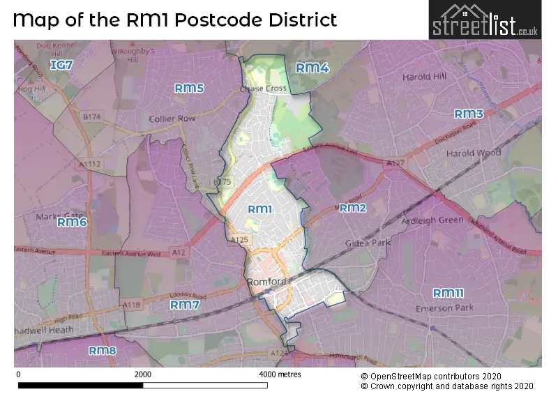
The RM1 Postcode shares a border with RM5 (ROMFORD), RM7 (ROMFORD, RUSH GREEN), RM2 (ROMFORD, GIDEA PARK), RM3 (ROMFORD), RM11 (HORNCHURCH) and RM12 (HORNCHURCH).
The primary settlement in the RM1 postcode district is Romford, which is located in the county of Greater London in England. Other significant settlements within this postcode district include Romford, Romford, and Romford. Romford is the most significant post town with the highest number of postcodes.
For the district RM1, we have data on 4 postcode sectors. Here's a breakdown: The sector RM1 1, covers Romford in Greater London. The sector RM1 2, covers Romford in Greater London. The sector RM1 3, covers Romford in Greater London. The sector RM1 4, covers Romford in Greater London.


Map of the RM1 Postcode District
Explore the RM1 postcode district by using our free interactive map.
When it comes to local government, postal geography often disregards political borders. However, for a breakdown in the RM1 District: the district mostly encompasses the Havering London Boro area with a total of 500 postcodes.
Recent House Sales in RM13
| Date | Price | Address |
|---|---|---|
| 18/10/2023 | £472,500 | Fairview Avenue, Rainham, RM13 9RP |
| 02/10/2023 | £258,500 | Bader Way, Rainham, RM13 7HU |
| 12/09/2023 | £580,000 | Lovell Walk, Rainham, RM13 7ND |
| 11/09/2023 | £420,000 | Lake Avenue, Rainham, RM13 9SQ |
| 08/09/2023 | £350,000 | Jersey Road, Rainham, RM13 7DR |
| 05/09/2023 | £430,000 | Lakeside, Rainham, RM13 9SW |
| 04/09/2023 | £420,000 | Kingaby Gardens, Rainham, RM13 7PH |
| 31/08/2023 | £395,000 | Louise Gardens, Rainham, RM13 8LH |
| 25/08/2023 | £280,000 | South End Road, Rainham, RM13 7XS |
| 24/08/2023 | £410,000 | Sunningdale Avenue, Rainham, RM13 9NR |
Weather Forecast for RM1
Press Button to Show Forecast for Romford
| Time Period | Icon | Description | Temperature | Rain Probability | Wind |
|---|---|---|---|---|---|
| 12:00 to 15:00 | Cloudy | 11.0°C (feels like 8.0°C) | 11.00% | WNW 11 mph | |
| 15:00 to 18:00 | Cloudy | 11.0°C (feels like 9.0°C) | 50.00% | WNW 9 mph | |
| 18:00 to 21:00 | Cloudy | 9.0°C (feels like 7.0°C) | 11.00% | NNW 7 mph | |
| 21:00 to 00:00 | Cloudy | 7.0°C (feels like 5.0°C) | 9.00% | ENE 7 mph |
Press Button to Show Forecast for Romford
| Time Period | Icon | Description | Temperature | Rain Probability | Wind |
|---|---|---|---|---|---|
| 00:00 to 03:00 | Cloudy | 6.0°C (feels like 4.0°C) | 5.00% | NE 7 mph | |
| 03:00 to 06:00 | Cloudy | 5.0°C (feels like 3.0°C) | 5.00% | NE 7 mph | |
| 06:00 to 09:00 | Cloudy | 5.0°C (feels like 2.0°C) | 4.00% | NE 7 mph | |
| 09:00 to 12:00 | Cloudy | 8.0°C (feels like 6.0°C) | 4.00% | ENE 7 mph | |
| 12:00 to 15:00 | Cloudy | 11.0°C (feels like 9.0°C) | 10.00% | E 7 mph | |
| 15:00 to 18:00 | Cloudy | 10.0°C (feels like 9.0°C) | 10.00% | E 7 mph | |
| 18:00 to 21:00 | Cloudy | 9.0°C (feels like 8.0°C) | 10.00% | E 7 mph | |
| 21:00 to 00:00 | Cloudy | 7.0°C (feels like 5.0°C) | 9.00% | E 7 mph |
Press Button to Show Forecast for Romford
| Time Period | Icon | Description | Temperature | Rain Probability | Wind |
|---|---|---|---|---|---|
| 00:00 to 03:00 | Cloudy | 5.0°C (feels like 3.0°C) | 12.00% | ENE 7 mph | |
| 03:00 to 06:00 | Cloudy | 5.0°C (feels like 3.0°C) | 17.00% | NE 7 mph | |
| 06:00 to 09:00 | Light rain | 6.0°C (feels like 4.0°C) | 47.00% | NE 7 mph | |
| 09:00 to 12:00 | Overcast | 10.0°C (feels like 8.0°C) | 20.00% | E 9 mph | |
| 12:00 to 15:00 | Cloudy | 12.0°C (feels like 10.0°C) | 16.00% | E 11 mph | |
| 15:00 to 18:00 | Cloudy | 12.0°C (feels like 10.0°C) | 18.00% | E 11 mph | |
| 18:00 to 21:00 | Light rain | 11.0°C (feels like 9.0°C) | 52.00% | ENE 9 mph | |
| 21:00 to 00:00 | Light rain | 10.0°C (feels like 7.0°C) | 52.00% | ENE 11 mph |
Press Button to Show Forecast for Romford
| Time Period | Icon | Description | Temperature | Rain Probability | Wind |
|---|---|---|---|---|---|
| 00:00 to 03:00 | Heavy rain | 9.0°C (feels like 7.0°C) | 73.00% | ENE 9 mph | |
| 03:00 to 06:00 | Heavy rain shower (night) | 10.0°C (feels like 8.0°C) | 60.00% | ESE 9 mph | |
| 06:00 to 09:00 | Light rain shower (day) | 10.0°C (feels like 8.0°C) | 39.00% | ESE 7 mph | |
| 09:00 to 12:00 | Light rain shower (day) | 11.0°C (feels like 9.0°C) | 40.00% | SE 9 mph | |
| 12:00 to 15:00 | Heavy rain shower (day) | 13.0°C (feels like 11.0°C) | 64.00% | S 11 mph | |
| 15:00 to 18:00 | Light rain shower (day) | 14.0°C (feels like 12.0°C) | 41.00% | SSW 11 mph | |
| 18:00 to 21:00 | Light rain shower (day) | 13.0°C (feels like 11.0°C) | 34.00% | WSW 11 mph | |
| 21:00 to 00:00 | Cloudy | 10.0°C (feels like 9.0°C) | 7.00% | SW 7 mph |
Where is the RM1 Postcode District?
The postcode district RM1 is located in the town of Romford. Romford is situated about 14.56 miles away from central London. It is surrounded by several nearby towns: Gidea Park to the East (0.70 miles), Mawneys to the South West (0.86 miles), Collier Row to the North West (1.29 miles), Harold Hill to the North East (1.92 miles), Havering-atte-Bower to the North (2.01 miles), Rush Green to the South (2.06 miles), and Emerson Park to the South East (2.22 miles).
The district is within the post town of ROMFORD.
The sector has postcodes within the nation of England.
The RM1 Postcode District is in the Barking & Dagenham and Havering region of Outer London - East and North East within the London.
Postcode Sectors within the RM1 District
| Postcode Sector | Delivery Office |
|---|---|
| RM1 1 | Romford Delivery Office |
| RM1 2 | Romford Delivery Office |
| RM1 3 | Romford Delivery Office |
| RM1 4 | Romford Delivery Office |
| R | M | 1 | - | X | X | X |
| R | M | 1 | Space | Numeric | Letter | Letter |
Tourist Attractions within the Postcode Area
We found 1 visitor attractions within the RM1 postcode area
| Havering Museum |
|---|
| Museums & Art Galleries |
| Museum and / or Art Gallery |
| View Havering Museum on Google Maps |
Current Monthly Rental Prices
| # Bedrooms | Min Price | Max Price | Avg Price |
|---|---|---|---|
| 1 | £1,300 | £1,673 | £1,542 |
| 2 | £1,200 | £1,800 | £1,620 |
| 3 | £1,900 | £2,500 | £2,240 |
| 5 | £2,600 | £2,600 | £2,600 |
Current House Prices
| # Bedrooms | Min Price | Max Price | Avg Price |
|---|---|---|---|
| £30,000 | £1,935,000 | £452,727 | |
| 1 | £90,000 | £310,000 | £202,402 |
| 2 | £30,000 | £550,000 | £290,949 |
| 3 | £275,000 | £850,000 | £488,750 |
| 4 | £525,000 | £1,150,000 | £691,250 |
| 5 | £575,000 | £850,000 | £708,333 |
Estate Agents who Operate in the RM1 District
| Logo | Name | Brand Name | Address | Contact Number | Total Properties |
|---|---|---|---|---|---|
 | Romford | haart | 153/159 South Street Romford RM1 1PL | 01708 205780 | 19 |
 | Romford | Balgores | 5-6 Station Chambers, Victoria Road, Romford, RM1 2HU | 01708 204467 | 14 |
 | at Gidea Park | Beresfords | 85 Main Road, Gidea Park, Romford, RM2 5EL | 01708 961741 | 13 |
 | Romford | Accord Sales & Lettings | 221 Pettits Lane North Romford RM1 4NU | 07723 185475 | 9 |
 | Romford Lettings | haart | 153/159 South Street, Romford, RM1 1PL | 01708 984659 | 8 |
| Type of Property | 2018 Average | 2018 Sales | 2017 Average | 2017 Sales | 2016 Average | 2016 Sales | 2015 Average | 2015 Sales |
|---|---|---|---|---|---|---|---|---|
| Detached | £572,594 | 16 | £587,534 | 29 | £542,607 | 28 | £505,530 | 27 |
| Semi-Detached | £444,416 | 109 | £424,229 | 108 | £417,799 | 110 | £370,142 | 120 |
| Terraced | £376,994 | 84 | £381,525 | 62 | £359,029 | 70 | £303,398 | 69 |
| Flats | £233,036 | 142 | £242,921 | 223 | £230,110 | 331 | £215,924 | 167 |