The RM3 postcode district is a postal district located in the RM Romford postcode area with a population of 48,053 residents according to the 2021 England and Wales Census.
The area of the RM3 postcode district is 5.48 square miles which is 14.19 square kilometres or 3,506.07 acres.
Currently, the RM3 district has about 928 postcode units spread across 4 geographic postcode sectors.
Given that each sector allows for 400 unique postcode combinations, the district has a capacity of 1,600 postcodes. With 928 postcodes already in use, this leaves 672 units available.
The RM3 postal code covers the settlement of ROMFORD.
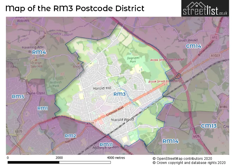
The RM3 Postcode shares a border with RM2 (ROMFORD, GIDEA PARK), RM1 (ROMFORD), RM11 (HORNCHURCH), RM14 (UPMINSTER, Bulphan, NORTH OCKENDON), RM4 (LAMBOURNE, STAPLEFORD ABBOTTS, HAVERING-ATTE-BOWER) and CM14 (BRENTWOOD, Warley, Pilgrims Hatch).
In the RM3 postcode district, the primary settlement is Romford. Other significant settlements include Harold Wood, Noak Hill, and Harold Hill. The post town for this district is Romford and it is located in the county of Greater London.
For the district RM3, we have data on 5 postcode sectors. Here's a breakdown: The sector RM3 0, covers Romford and Harold Wood in Greater London. The sector RM3 3 is non-geographic. It's often designated for PO Boxes, large organisations, or special services. The sector RM3 7, covers Romford in Greater London. The sector RM3 8, covers Romford in Greater London. The sector RM3 9, covers Romford in Greater London.

Map of the RM3 Postcode District
Explore the RM3 postcode district by using our free interactive map.
When it comes to local government, postal geography often disregards political borders. However, for a breakdown in the RM3 District: the district mostly encompasses the Havering London Boro area with a total of 928 postcodes.
Recent House Sales in RM3
| Date | Price | Address |
|---|---|---|
| 13/10/2023 | £627,000 | Kenilworth Avenue, Romford, RM3 9NE |
| 06/10/2023 | £296,000 | St Neots Road, Romford, RM3 9LR |
| 29/09/2023 | £425,000 | Dorking Road, Romford, RM3 9YU |
| 29/09/2023 | £725,000 | Shepherds Hill, Harold Wood, Romford, RM3 0NJ |
| 29/09/2023 | £375,000 | Archway, Romford, RM3 7EB |
| 22/09/2023 | £205,000 | Veronica Close, Romford, RM3 8JN |
| 18/09/2023 | £320,000 | Whitmore Avenue, Harold Wood, Romford, RM3 0WY |
| 15/09/2023 | £275,000 | Cavell Crescent, Harold Wood, Romford, RM3 0WL |
| 14/09/2023 | £575,000 | Arlington Gardens, Harold Wood, Romford, RM3 0EA |
| 11/09/2023 | £390,000 | Gubbins Lane, Harold Wood, Romford, RM3 0NQ |
Weather Forecast for RM3
Press Button to Show Forecast for Romford
| Time Period | Icon | Description | Temperature | Rain Probability | Wind |
|---|---|---|---|---|---|
| 18:00 to 21:00 | Cloudy | 9.0°C (feels like 7.0°C) | 5.00% | N 11 mph | |
| 21:00 to 00:00 | Cloudy | 7.0°C (feels like 5.0°C) | 4.00% | N 7 mph |
Press Button to Show Forecast for Romford
| Time Period | Icon | Description | Temperature | Rain Probability | Wind |
|---|---|---|---|---|---|
| 00:00 to 03:00 | Clear night | 6.0°C (feels like 3.0°C) | 0.00% | NW 7 mph | |
| 03:00 to 06:00 | Clear night | 4.0°C (feels like 1.0°C) | 0.00% | NNW 9 mph | |
| 06:00 to 09:00 | Partly cloudy (day) | 4.0°C (feels like 1.0°C) | 1.00% | NNW 9 mph | |
| 09:00 to 12:00 | Cloudy | 8.0°C (feels like 5.0°C) | 4.00% | NNW 13 mph | |
| 12:00 to 15:00 | Cloudy | 10.0°C (feels like 8.0°C) | 4.00% | NNW 13 mph | |
| 15:00 to 18:00 | Cloudy | 11.0°C (feels like 8.0°C) | 5.00% | NNW 11 mph | |
| 18:00 to 21:00 | Cloudy | 9.0°C (feels like 7.0°C) | 4.00% | N 9 mph | |
| 21:00 to 00:00 | Clear night | 7.0°C (feels like 5.0°C) | 1.00% | NE 4 mph |
Press Button to Show Forecast for Romford
| Time Period | Icon | Description | Temperature | Rain Probability | Wind |
|---|---|---|---|---|---|
| 00:00 to 03:00 | Cloudy | 5.0°C (feels like 4.0°C) | 4.00% | WSW 4 mph | |
| 03:00 to 06:00 | Cloudy | 5.0°C (feels like 3.0°C) | 4.00% | WSW 4 mph | |
| 06:00 to 09:00 | Cloudy | 6.0°C (feels like 4.0°C) | 5.00% | WSW 7 mph | |
| 09:00 to 12:00 | Cloudy | 9.0°C (feels like 7.0°C) | 7.00% | W 9 mph | |
| 12:00 to 15:00 | Cloudy | 11.0°C (feels like 9.0°C) | 9.00% | WNW 9 mph | |
| 15:00 to 18:00 | Overcast | 12.0°C (feels like 10.0°C) | 14.00% | WNW 9 mph | |
| 18:00 to 21:00 | Overcast | 10.0°C (feels like 9.0°C) | 14.00% | NW 7 mph | |
| 21:00 to 00:00 | Cloudy | 8.0°C (feels like 6.0°C) | 7.00% | NNE 4 mph |
Press Button to Show Forecast for Romford
| Time Period | Icon | Description | Temperature | Rain Probability | Wind |
|---|---|---|---|---|---|
| 00:00 to 03:00 | Cloudy | 6.0°C (feels like 5.0°C) | 4.00% | NE 4 mph | |
| 03:00 to 06:00 | Cloudy | 5.0°C (feels like 4.0°C) | 5.00% | NE 4 mph | |
| 06:00 to 09:00 | Cloudy | 6.0°C (feels like 4.0°C) | 7.00% | ENE 4 mph | |
| 09:00 to 12:00 | Cloudy | 9.0°C (feels like 7.0°C) | 7.00% | E 7 mph | |
| 12:00 to 15:00 | Overcast | 11.0°C (feels like 9.0°C) | 13.00% | SE 9 mph | |
| 15:00 to 18:00 | Cloudy | 11.0°C (feels like 9.0°C) | 12.00% | SE 9 mph | |
| 18:00 to 21:00 | Cloudy | 10.0°C (feels like 8.0°C) | 11.00% | ESE 9 mph | |
| 21:00 to 00:00 | Cloudy | 8.0°C (feels like 6.0°C) | 10.00% | ESE 7 mph |
Press Button to Show Forecast for Romford
| Time Period | Icon | Description | Temperature | Rain Probability | Wind |
|---|---|---|---|---|---|
| 00:00 to 03:00 | Overcast | 8.0°C (feels like 6.0°C) | 17.00% | ESE 7 mph | |
| 03:00 to 06:00 | Cloudy | 7.0°C (feels like 6.0°C) | 15.00% | E 7 mph | |
| 06:00 to 09:00 | Overcast | 8.0°C (feels like 6.0°C) | 16.00% | E 7 mph | |
| 09:00 to 12:00 | Cloudy | 11.0°C (feels like 9.0°C) | 12.00% | SE 9 mph | |
| 12:00 to 15:00 | Light rain | 13.0°C (feels like 11.0°C) | 40.00% | ESE 9 mph | |
| 15:00 to 18:00 | Light rain shower (day) | 13.0°C (feels like 11.0°C) | 32.00% | ESE 9 mph | |
| 18:00 to 21:00 | Cloudy | 12.0°C (feels like 11.0°C) | 14.00% | ENE 9 mph | |
| 21:00 to 00:00 | Cloudy | 11.0°C (feels like 9.0°C) | 12.00% | ENE 7 mph |
Where is the RM3 Postcode District?
The postcode district RM3 is located in Romford, which is a town in Greater London. It is situated approximately 16.78 miles away from the center of London. RM3 is surrounded by several nearby towns, including Harold Hill to the South West (0.32 miles), Harold Wood to the South East (0.81 miles), Noak Hill to the North (1.36 miles), South Weald to the North East (1.84 miles), Havering-Atte-Bower to the West (2.15 miles), and Emerson Park to the South (2.22 miles).
The district is within the post town of ROMFORD.
The sector has postcodes within the nation of England.
The RM3 Postcode District is in the Barking & Dagenham and Havering region of Outer London - East and North East within the London.
| Postcode Sector | Delivery Office |
|---|---|
| RM3 0 | Harold Hill Delivery Office |
| RM3 7 | Harold Hill Delivery Office |
| RM3 8 | Harold Hill Delivery Office |
| RM3 9 | Harold Hill Delivery Office |
| R | M | 3 | - | X | X | X |
| R | M | 3 | Space | Numeric | Letter | Letter |
Current Monthly Rental Prices
| # Bedrooms | Min Price | Max Price | Avg Price |
|---|---|---|---|
| £975 | £975 | £975 | |
| 1 | £975 | £1,400 | £1,200 |
| 2 | £1,300 | £2,000 | £1,631 |
| 3 | £3,750 | £3,750 | £3,750 |
| 5 | £2,500 | £3,000 | £2,750 |
Current House Prices
| # Bedrooms | Min Price | Max Price | Avg Price |
|---|---|---|---|
| 1 | £75,000 | £325,000 | £218,975 |
| 2 | £157,500 | £475,000 | £319,813 |
| 3 | £198,000 | £700,000 | £439,722 |
| 4 | £400,000 | £900,000 | £622,308 |
| 5 | £500,000 | £1,100,000 | £661,176 |
| 6 | £850,000 | £850,000 | £850,000 |
Estate Agents who Operate in the RM3 District
| Logo | Name | Brand Name | Address | Contact Number | Total Properties |
|---|---|---|---|---|---|
 | Harold Wood | haart | 49a Station Road, Harold Wood, Romford, RM3 0BS | 01708 205359 | 63 |
 | Harold Wood | Beresfords | 2 Queens Park Road, Harold Wood, Romford, RM3 0HJ | 01706 335901 | 34 |
 | Harold Wood | Delaney's | 29 Station Road, Harold Wood, Romford, RM3 0BP | 01708 205758 | 26 |
 | covering Romford | Purplebricks | Suite 7 First Floor Cranmore Drive Shirley Solihull B90 4RZ | 020 3910 6289 | 12 |
 | Hornchurch | Durden & Hunt | 159 High Street, Hornchurch, RM11 3YD | 01708 204294 | 11 |
| Type of Property | 2018 Average | 2018 Sales | 2017 Average | 2017 Sales | 2016 Average | 2016 Sales | 2015 Average | 2015 Sales |
|---|---|---|---|---|---|---|---|---|
| Detached | £513,432 | 22 | £494,088 | 34 | £468,182 | 33 | £423,145 | 48 |
| Semi-Detached | £389,042 | 160 | £368,916 | 148 | £364,922 | 196 | £324,746 | 284 |
| Terraced | £322,228 | 272 | £331,766 | 256 | £330,355 | 305 | £277,432 | 341 |
| Flats | £306,064 | 277 | £284,239 | 231 | £253,159 | 177 | £190,603 | 204 |