The S11 postcode district is a postal district located in the S Sheffield postcode area with a population of 34,918 residents according to the 2021 England and Wales Census.
The area of the S11 postcode district is 10.12 square miles which is 26.22 square kilometres or 6,479.99 acres.
Currently, the S11 district has about 658 postcode units spread across 3 geographic postcode sectors.
Given that each sector allows for 400 unique postcode combinations, the district has a capacity of 1,200 postcodes. With 658 postcodes already in use, this leaves 542 units available.
The S11 postal code covers the settlement of SHEFFIELD.
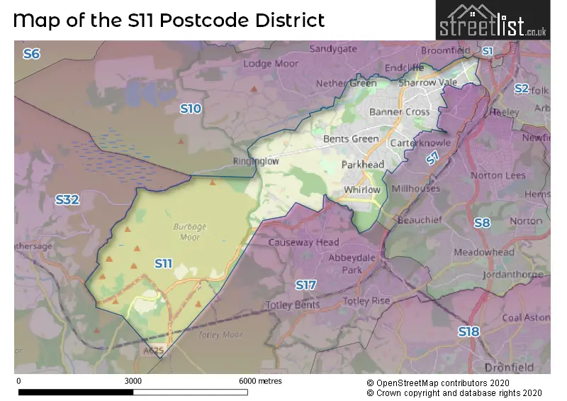
The S11 Postcode shares a border with S10 (SHEFFIELD), S17 (SHEFFIELD, Dore, Totley Rise), S32 (Hathersage, Calver, Eyam), S7 (SHEFFIELD) and S3 (SHEFFIELD).
The primary settlement in the S11 postcode district is Sheffield, which is located in South Yorkshire. Sheffield is the most significant settlement with a total count of 178. The other significant settlements in the district include Derbyshire and South Yorkshire, with counts of 1 and 229 respectively.
For the district S11, we have data on 4 postcode sectors. Here's a breakdown: The sector S11 0 is non-geographic. It's often designated for PO Boxes, large organisations, or special services. The sector S11 7, covers Sheffield in South Yorkshire. The sector S11 8, covers Sheffield in South Yorkshire. The sector S11 9, covers Sheffield in South Yorkshire.

Map of the S11 Postcode District
Explore the S11 postcode district by using our free interactive map.
When it comes to local government, postal geography often disregards political borders. However, for a breakdown in the S11 District: the district mostly encompasses the Sheffield District (B) area with a total of 658 postcodes.
Recent House Sales in S11
| Date | Price | Address |
|---|---|---|
| 13/10/2023 | £370,000 | High Storrs Road, Sheffield, S11 7LH |
| 10/10/2023 | £425,000 | Bingham Park Road, Sheffield, S11 7BD |
| 06/10/2023 | £230,000 | Stewart Road, Sheffield, S11 8XT |
| 04/10/2023 | £550,000 | Woodholm Road, Ecclesall, Sheffield, S11 9HS |
| 13/09/2023 | £890,000 | Chelsea Road, Sheffield, S11 9BQ |
| 07/09/2023 | £459,000 | Strathtay Road, Sheffield, S11 7GU |
| 07/09/2023 | £475,000 | Whinfell Court, Sheffield, S11 9QA |
| 06/09/2023 | £184,000 | Neill Road, Sheffield, S11 8QG |
| 06/09/2023 | £403,595 | Greystones Hall Road, Sheffield, S11 7BA |
| 05/09/2023 | £710,000 | Parkhead Road, Sheffield, S11 9RB |
Weather Forecast for S11
Press Button to Show Forecast for Hathersage Youth Hostel
| Time Period | Icon | Description | Temperature | Rain Probability | Wind |
|---|---|---|---|---|---|
| 00:00 to 03:00 | Clear night | 3.0°C (feels like 1.0°C) | 1.00% | NNW 4 mph | |
| 03:00 to 06:00 | Partly cloudy (night) | 2.0°C (feels like 0.0°C) | 1.00% | NNW 4 mph | |
| 06:00 to 09:00 | Partly cloudy (day) | 3.0°C (feels like 1.0°C) | 1.00% | NNW 4 mph | |
| 09:00 to 12:00 | Cloudy | 7.0°C (feels like 5.0°C) | 4.00% | NNW 7 mph | |
| 12:00 to 15:00 | Overcast | 9.0°C (feels like 7.0°C) | 8.00% | N 7 mph | |
| 15:00 to 18:00 | Overcast | 10.0°C (feels like 8.0°C) | 7.00% | N 7 mph | |
| 18:00 to 21:00 | Overcast | 9.0°C (feels like 8.0°C) | 7.00% | NNE 4 mph | |
| 21:00 to 00:00 | Cloudy | 7.0°C (feels like 5.0°C) | 4.00% | NE 4 mph |
Press Button to Show Forecast for Hathersage Youth Hostel
| Time Period | Icon | Description | Temperature | Rain Probability | Wind |
|---|---|---|---|---|---|
| 00:00 to 03:00 | Cloudy | 5.0°C (feels like 4.0°C) | 5.00% | NE 2 mph | |
| 03:00 to 06:00 | Cloudy | 5.0°C (feels like 4.0°C) | 12.00% | NNE 2 mph | |
| 06:00 to 09:00 | Overcast | 5.0°C (feels like 4.0°C) | 19.00% | N 2 mph | |
| 09:00 to 12:00 | Overcast | 6.0°C (feels like 5.0°C) | 17.00% | NE 4 mph | |
| 12:00 to 15:00 | Overcast | 8.0°C (feels like 6.0°C) | 15.00% | NE 7 mph | |
| 15:00 to 18:00 | Overcast | 9.0°C (feels like 7.0°C) | 14.00% | NE 7 mph | |
| 18:00 to 21:00 | Cloudy | 8.0°C (feels like 7.0°C) | 11.00% | NE 7 mph | |
| 21:00 to 00:00 | Cloudy | 6.0°C (feels like 5.0°C) | 12.00% | ENE 4 mph |
Press Button to Show Forecast for Hathersage Youth Hostel
| Time Period | Icon | Description | Temperature | Rain Probability | Wind |
|---|---|---|---|---|---|
| 00:00 to 03:00 | Cloudy | 5.0°C (feels like 4.0°C) | 12.00% | ENE 4 mph | |
| 03:00 to 06:00 | Overcast | 4.0°C (feels like 3.0°C) | 17.00% | E 2 mph | |
| 06:00 to 09:00 | Overcast | 5.0°C (feels like 3.0°C) | 19.00% | N 4 mph | |
| 09:00 to 12:00 | Light rain | 6.0°C (feels like 5.0°C) | 49.00% | ESE 4 mph | |
| 12:00 to 15:00 | Light rain | 8.0°C (feels like 7.0°C) | 50.00% | SSE 4 mph | |
| 15:00 to 18:00 | Light rain | 9.0°C (feels like 8.0°C) | 52.00% | SE 4 mph | |
| 18:00 to 21:00 | Overcast | 9.0°C (feels like 7.0°C) | 45.00% | NNE 4 mph | |
| 21:00 to 00:00 | Overcast | 8.0°C (feels like 6.0°C) | 16.00% | NE 4 mph |
Press Button to Show Forecast for Hathersage Youth Hostel
| Time Period | Icon | Description | Temperature | Rain Probability | Wind |
|---|---|---|---|---|---|
| 00:00 to 03:00 | Overcast | 7.0°C (feels like 6.0°C) | 14.00% | ENE 4 mph | |
| 03:00 to 06:00 | Overcast | 6.0°C (feels like 4.0°C) | 11.00% | NNE 7 mph | |
| 06:00 to 09:00 | Cloudy | 6.0°C (feels like 4.0°C) | 9.00% | N 7 mph | |
| 09:00 to 12:00 | Overcast | 8.0°C (feels like 6.0°C) | 10.00% | NE 9 mph | |
| 12:00 to 15:00 | Cloudy | 10.0°C (feels like 8.0°C) | 9.00% | NNE 9 mph | |
| 15:00 to 18:00 | Cloudy | 11.0°C (feels like 9.0°C) | 11.00% | NNE 9 mph | |
| 18:00 to 21:00 | Cloudy | 10.0°C (feels like 8.0°C) | 6.00% | NNE 9 mph | |
| 21:00 to 00:00 | Clear night | 7.0°C (feels like 5.0°C) | 5.00% | NNE 7 mph |
Where is the S11 Postcode District?
The data shows that the postcode district for S11 is located in Sheffield, a town in South Yorkshire. Sheffield is situated near several nearby towns, including Dronfield (4.7 miles to the South East), Bakewell (10.2 miles to the South West), Rotherham (12 miles to the North East), Matlock (14.9 miles to the South), Barnsley (15.1 miles to the North), and Glossop (17.5 miles to the West). Furthermore, the distance from Sheffield's postcode district to London's city center is approximately 140.5 miles.
The district is within the post town of SHEFFIELD.
The sector has postcodes within the nation of England.
The S11 Postcode District is covers the following regions.
- Sheffield - South Yorkshire - Yorkshire and The Humber
- South and West Derbyshire - Derbyshire and Nottinghamshire - East Midlands (England)
| Postcode Sector | Delivery Office |
|---|---|
| S11 7 | Sheffield Swpostal Delivery Office |
| S11 8 | Sheffield Swpostal Delivery Office |
| S11 9 | Sheffield Swpostal Delivery Office |
| S | 1 | 1 | - | X | X | X |
| S | 1 | 1 | Space | Numeric | Letter | Letter |
Current Monthly Rental Prices
| # Bedrooms | Min Price | Max Price | Avg Price |
|---|---|---|---|
| £100 | £833 | £587 | |
| 1 | £277 | £950 | £687 |
| 2 | £725 | £1,950 | £1,181 |
| 3 | £312 | £2,250 | £1,121 |
| 4 | £275 | £2,100 | £664 |
| 5 | £300 | £3,185 | £787 |
| 6 | £303 | £2,600 | £1,174 |
| 7 | £351 | £3,458 | £890 |
| 8 | £342 | £407 | £375 |
| 9 | £325 | £325 | £325 |
Current House Prices
| # Bedrooms | Min Price | Max Price | Avg Price |
|---|---|---|---|
| £85,000 | £2,000,000 | £500,000 | |
| 1 | £80,000 | £190,000 | £129,995 |
| 2 | £150,000 | £450,000 | £261,579 |
| 3 | £200,000 | £700,000 | £381,250 |
| 4 | £240,000 | £1,150,000 | £551,667 |
| 5 | £275,000 | £1,100,000 | £565,000 |
| 6 | £325,000 | £2,499,995 | £1,187,777 |
| 10 | £615,000 | £615,000 | £615,000 |
Estate Agents who Operate in the S11 District
| Logo | Name | Brand Name | Address | Contact Number | Total Properties |
|---|---|---|---|---|---|
 | Banner Cross | Whitehornes | 952 Ecclesall Road, Sheffield, S11 8TR | 0114 697 3517 | 22 |
 | Sheffield | Dove Properties | 430 Ecclesall Road, Sheffield, S11 8PX | 0114 697 1436 | 21 |
 | Sheffield | Fit Property | 144 Charles Street, Sheffield, S1 2NE | 0114 697 2820 | 18 |
 | Sheffield | Saxton Mee | 949-951 Ecclesall Road Sheffield S11 8TN | 0114 697 1645 | 13 |
 | Sheffield | Redbrik | 837 Ecclesall Road Sheffield S11 8TH | 0114 697 4292 | 11 |
| Type of Property | 2018 Average | 2018 Sales | 2017 Average | 2017 Sales | 2016 Average | 2016 Sales | 2015 Average | 2015 Sales |
|---|---|---|---|---|---|---|---|---|
| Detached | £505,130 | 104 | £473,236 | 100 | £500,054 | 105 | £429,299 | 99 |
| Semi-Detached | £353,128 | 153 | £332,522 | 167 | £332,992 | 118 | £308,932 | 134 |
| Terraced | £250,510 | 201 | £241,682 | 161 | £225,857 | 197 | £227,606 | 228 |
| Flats | £192,880 | 89 | £181,813 | 100 | £181,372 | 95 | £167,296 | 128 |
Hotels within the Postcode Area
We found 4 hotels and guest houses within the S11 postcode area
Innkeeper's Lodge Hathersage, Peak District
The Fox House Vintage Inn, Hathersage Road, Sheffield, sheffield, S11 7TY.
View detailsBrocco On The Park Boutique Hotel
92 Brocco Bank, Sheffield, South Yorkshire, Sheffield, sheffield, S11 8RS.
View details