The S32 postcode district is a postal district located in the S Sheffield postcode area with a population of 5,620 residents according to the 2021 England and Wales Census.
The area of the S32 postcode district is 26.28 square miles which is 68.06 square kilometres or 16,816.79 acres.
Currently, the S32 district has about 209 postcode units spread across 5 geographic postcode sectors.
Given that each sector allows for 400 unique postcode combinations, the district has a capacity of 2,000 postcodes. With 209 postcodes already in use, this leaves 1791 units available.
The largest settlement in the S32 postal code is Hathersage followed by Calver, and Eyam.
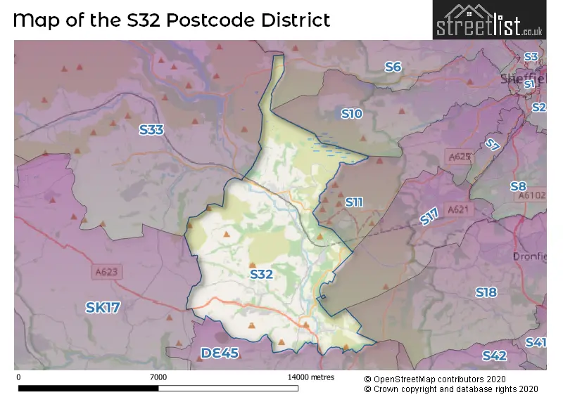
The S32 Postcode shares a border with S33 (Bamford, Bradwell, Hope), DE45 (BAKEWELL, Youlgrave, Baslow), S11 (SHEFFIELD), S17 (SHEFFIELD, Dore, Totley Rise) and SK17 (BUXTON, Tideswell, Dove Holes).
The primary settlement in the S32 postcode district is Hathersage, located in the county of Derbyshire in England. Other significant settlements in the district include Grindleford, Calver, Great Longstone, Stoney Middleton, and Eyam, all also in Derbyshire. The most significant post town in the district is Hope Valley.
For the district S32, we have data on 5 postcode sectors. Here's a breakdown: The sector S32 1, covers Hathersage in Derbyshire. The sector S32 2, covers Grindleford in Derbyshire. The sector S32 3, covers Calver in Derbyshire. The sector S32 4, covers Stoney Middleton in Derbyshire. The sector S32 5, covers Eyam in Derbyshire.

Map of the S32 Postcode District
Explore the S32 postcode district by using our free interactive map.
When it comes to local government, postal geography often disregards political borders. However, for a breakdown in the S32 District: the district mostly encompasses the Derbyshire Dales District area with a total of 208 postcodes.
Recent House Sales in S32
| Date | Price | Address |
|---|---|---|
| 05/09/2023 | £1,320,000 | Cliff Lane, Curbar, Hope Valley, S32 3XD |
| 31/08/2023 | £405,000 | Eyam Woodlands, Grindleford, Hope Valley, S32 2HF |
| 31/08/2023 | £820,000 | Upper Padley, Hope Valley, S32 2JA |
| 31/08/2023 | £400,000 | Denman Crescent, Stoney Middleton, Hope Valley, S32 4TG |
| 22/08/2023 | £400,000 | Sir William Hill Road, Grindleford, Hope Valley, S32 2HS |
| 17/08/2023 | £335,000 | Lowside Close, Calver, Hope Valley, S32 3WZ |
| 11/08/2023 | £250,000 | New Close, Eyam, Hope Valley, S32 5QX |
| 09/08/2023 | £1,065,000 | High Street, Calver, Hope Valley, S32 3XP |
| 07/08/2023 | £350,000 | Trinkey Lane, Stoney Middleton, Hope Valley, S32 4TX |
| 07/08/2023 | £438,000 | Smithy Knoll Road, Calver, Hope Valley, S32 3XW |
Weather Forecast for S32
Press Button to Show Forecast for Eyam Youth Hostel
| Time Period | Icon | Description | Temperature | Rain Probability | Wind |
|---|---|---|---|---|---|
| 12:00 to 15:00 | Overcast | 4.0°C (feels like 1.0°C) | 50.00% | N 7 mph | |
| 15:00 to 18:00 | Cloudy | 6.0°C (feels like 4.0°C) | 38.00% | NNE 4 mph | |
| 18:00 to 21:00 | Cloudy | 5.0°C (feels like 2.0°C) | 8.00% | NNE 7 mph | |
| 21:00 to 00:00 | Cloudy | 3.0°C (feels like 1.0°C) | 7.00% | ENE 4 mph |
Press Button to Show Forecast for Eyam Youth Hostel
| Time Period | Icon | Description | Temperature | Rain Probability | Wind |
|---|---|---|---|---|---|
| 00:00 to 03:00 | Partly cloudy (night) | 1.0°C (feels like -1.0°C) | 2.00% | E 4 mph | |
| 03:00 to 06:00 | Clear night | 0.0°C (feels like -3.0°C) | 1.00% | NNE 4 mph | |
| 06:00 to 09:00 | Sunny day | 1.0°C (feels like -2.0°C) | 1.00% | N 4 mph | |
| 09:00 to 12:00 | Cloudy | 4.0°C (feels like 1.0°C) | 5.00% | ENE 7 mph | |
| 12:00 to 15:00 | Overcast | 6.0°C (feels like 5.0°C) | 9.00% | ENE 4 mph | |
| 15:00 to 18:00 | Cloudy | 7.0°C (feels like 6.0°C) | 6.00% | E 4 mph | |
| 18:00 to 21:00 | Cloudy | 6.0°C (feels like 4.0°C) | 7.00% | E 7 mph | |
| 21:00 to 00:00 | Partly cloudy (night) | 3.0°C (feels like 0.0°C) | 5.00% | ENE 7 mph |
Press Button to Show Forecast for Eyam Youth Hostel
| Time Period | Icon | Description | Temperature | Rain Probability | Wind |
|---|---|---|---|---|---|
| 00:00 to 03:00 | Cloudy | 1.0°C (feels like -1.0°C) | 8.00% | NE 4 mph | |
| 03:00 to 06:00 | Cloudy | 1.0°C (feels like -2.0°C) | 10.00% | NE 4 mph | |
| 06:00 to 09:00 | Cloudy | 2.0°C (feels like -1.0°C) | 11.00% | NE 7 mph | |
| 09:00 to 12:00 | Cloudy | 5.0°C (feels like 2.0°C) | 12.00% | ENE 9 mph | |
| 12:00 to 15:00 | Overcast | 7.0°C (feels like 4.0°C) | 20.00% | E 11 mph | |
| 15:00 to 18:00 | Cloudy | 7.0°C (feels like 4.0°C) | 21.00% | ENE 11 mph | |
| 18:00 to 21:00 | Cloudy | 7.0°C (feels like 3.0°C) | 20.00% | ENE 11 mph | |
| 21:00 to 00:00 | Cloudy | 4.0°C (feels like 1.0°C) | 18.00% | ENE 11 mph |
Press Button to Show Forecast for Eyam Youth Hostel
| Time Period | Icon | Description | Temperature | Rain Probability | Wind |
|---|---|---|---|---|---|
| 00:00 to 03:00 | Light rain | 4.0°C (feels like 0.0°C) | 49.00% | NE 13 mph | |
| 03:00 to 06:00 | Light rain | 4.0°C (feels like 0.0°C) | 51.00% | NNE 13 mph | |
| 06:00 to 09:00 | Heavy rain | 4.0°C (feels like 0.0°C) | 76.00% | NNE 16 mph | |
| 09:00 to 12:00 | Heavy rain | 5.0°C (feels like 1.0°C) | 79.00% | NNE 13 mph | |
| 12:00 to 15:00 | Light rain | 7.0°C (feels like 3.0°C) | 56.00% | NNE 13 mph | |
| 15:00 to 18:00 | Light rain | 7.0°C (feels like 4.0°C) | 54.00% | NNE 11 mph | |
| 18:00 to 21:00 | Light rain shower (day) | 7.0°C (feels like 4.0°C) | 35.00% | NNW 11 mph | |
| 21:00 to 00:00 | Partly cloudy (night) | 5.0°C (feels like 2.0°C) | 10.00% | NNE 9 mph |
Where is the S32 Postcode District?
The postcode district S32 is located in the town of Hope Valley. It is close to several nearby towns, including Bakewell to the south (located 6.56 miles away), Sheffield to the northeast (located 7.79 miles away), Dronfield to the east (located 7.92 miles away), Buxton to the southwest (located 10.49 miles away), Chesterfield to the southeast (located 11.93 miles away), and Glossop to the northwest (located 15.06 miles away). Additionally, the distance from Hope Valley to the center of London is approximately 140.27 miles.
The district is within the post town of HOPE VALLEY.
The sector has postcodes within the nation of England.
The S32 Postcode District is covers the following regions.
- South and West Derbyshire - Derbyshire and Nottinghamshire - East Midlands (England)
- East Derbyshire - Derbyshire and Nottinghamshire - East Midlands (England)
- Sheffield - South Yorkshire - Yorkshire and The Humber
| Postcode Sector | Delivery Office |
|---|---|
| S32 1 | Hathersage Scale Payment Delivery Office |
| S32 2 | Grindleford Scale Payment Delivery Office |
| S32 3 | Calver Scale Payment Delivery Office |
| S32 4 | Stoney Middleton Scale Payment Delivery Office |
| S32 4 | Calver Scale Payment Delivery Office |
| S32 5 | Eyam Scale Payment Delivery Office |
| S | 3 | 2 | - | X | X | X |
| S | 3 | 2 | Space | Numeric | Letter | Letter |
Tourist Attractions within the Postcode Area
We found 1 visitor attractions within the S32 postcode area
| Padley Manor, Gatehouse & Chapel |
|---|
| Places of Worship |
| Place of Worship (still in use) |
| View Padley Manor, Gatehouse & Chapel on Google Maps |
Current Monthly Rental Prices
| # Bedrooms | Min Price | Max Price | Avg Price |
|---|---|---|---|
| £440 | £440 | £440 | |
| 2 | £800 | £800 | £800 |
| 3 | £1,500 | £1,500 | £1,500 |
| 4 | £1,950 | £1,950 | £1,950 |
Current House Prices
| # Bedrooms | Min Price | Max Price | Avg Price |
|---|---|---|---|
| £40,000 | £275,000 | £154,400 | |
| 1 | £176,000 | £245,000 | £201,917 |
| 2 | £270,000 | £475,000 | £370,833 |
| 3 | £399,950 | £625,000 | £487,090 |
| 4 | £500,000 | £1,175,000 | £751,667 |
| 6 | £1,895,000 | £1,895,000 | £1,895,000 |
Estate Agents who Operate in the S32 District
| Logo | Name | Brand Name | Address | Contact Number | Total Properties |
|---|---|---|---|---|---|
 | Hathersage | Eadon Lockwood & Riddle | Main Road, Hathersage, Hope Valley, S32 1BB | 01433 449387 | 8 |
 | Hathersage | Saxton Mee | 3 Bank View, Main Road, Hathersage, Hope Valley, S32 1BB | 01433 449386 | 6 |
 | Bakewell | Bagshaws Residential | Bridge Street, Bakewell, Derbyshire, DE45 1DS | 01629 701321 | 3 |
 | Bakewell | Bagshaws | The Agricultural Business Centre, Agricultural Way, Bakewell, DE45 1AH | 01629 701331 | 3 |
 | Sheffield New Homes | Redbrik | 837 Ecclesall Road Sheffield S11 8TH | 0114 697 9176 | 3 |
| Type of Property | 2018 Average | 2018 Sales | 2017 Average | 2017 Sales | 2016 Average | 2016 Sales | 2015 Average | 2015 Sales |
|---|---|---|---|---|---|---|---|---|
| Detached | £484,684 | 27 | £491,425 | 44 | £588,614 | 40 | £461,470 | 33 |
| Semi-Detached | £303,313 | 8 | £378,523 | 20 | £304,763 | 23 | £318,363 | 19 |
| Terraced | £283,969 | 17 | £247,028 | 32 | £256,262 | 36 | £234,278 | 27 |
| Flats | £380,000 | 4 | £271,500 | 2 | £293,454 | 12 | £230,938 | 8 |