The S80 postcode district is a postal district located in the S Sheffield postcode area with a population of 30,843 residents according to the 2021 England and Wales Census.
The area of the S80 postcode district is 40.28 square miles which is 104.31 square kilometres or 25,776.35 acres.
Currently, the S80 district has about 988 postcode units spread across 4 geographic postcode sectors.
Given that each sector allows for 400 unique postcode combinations, the district has a capacity of 1,600 postcodes. With 988 postcodes already in use, this leaves 612 units available.
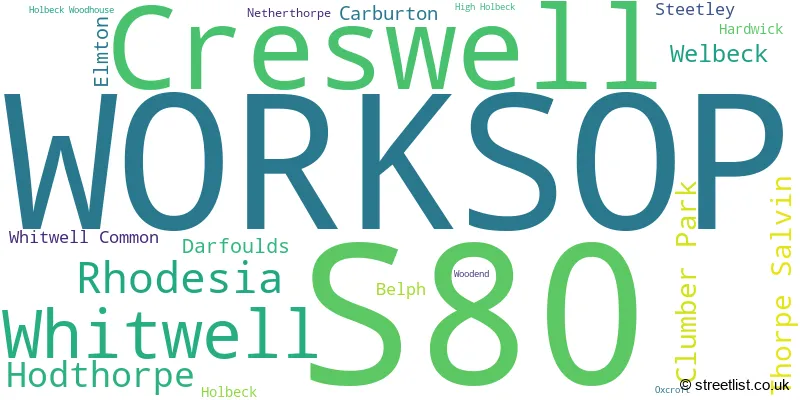
The largest settlement in the S80 postal code is WORKSOP followed by Creswell, and Whitwell.
The S80 Postcode shares a border with S43 (Brimington, Clowne, Staveley), S26 (Swallownest, Aston, Kiveton Park), S81 (WORKSOP, Carlton-in-Lindrick, Langold), DN22 (RETFORD, Ranskill, Clarborough), NG20 (Shirebrook, Warsop, Langwith) and NG22 (New Ollerton, Bilsthorpe, Tuxford).
The S80 postcode district primarily consists of the settlement of Worksop, located in the county of Nottinghamshire. Other significant settlements within this district include Belph, Carburton, Clumber Park, Darfoulds, Hardwick, High Holbeck, Holbeck, Holbeck Woodhouse, Netherthorpe, Rhodesia, Steetley, Thorpe Salvin, Welbeck, Whitwell, Whitwell Common, and Woodend. Worksop is also the main Post Town for this district.
For the district S80, we have data on 5 postcode sectors. Here's a breakdown: The sector S80 1, covers Worksop in Nottinghamshire. The sector S80 2, covers Worksop in Nottinghamshire. The sector S80 3, covers Worksop and Rhodesia in Nottinghamshire. The sector S80 4, covers Creswell and Whitwell in Derbyshire. The sector S80 9 is non-geographic. It's often designated for PO Boxes, large organisations, or special services.

Map of the S80 Postcode District
Explore the S80 postcode district by using our free interactive map.
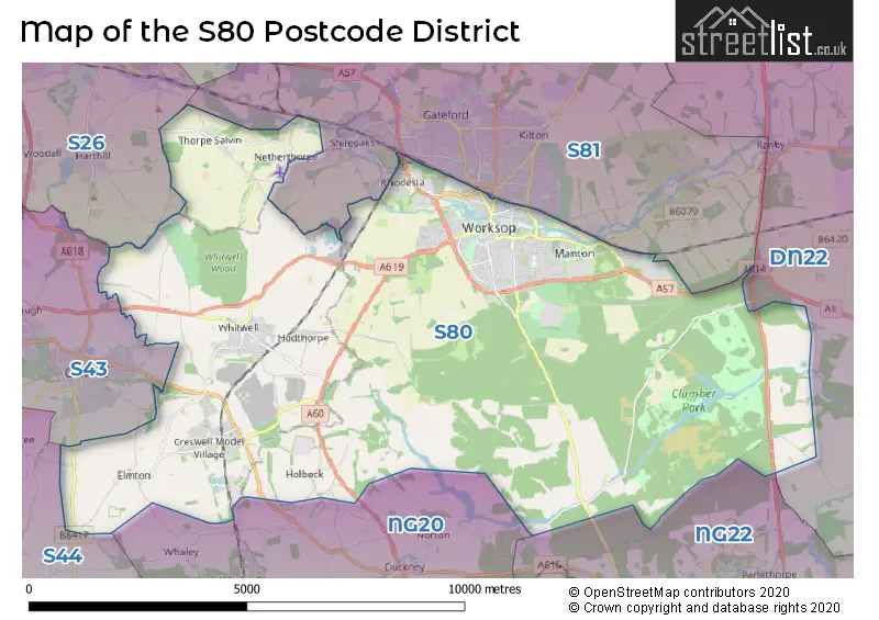
When it comes to local government, postal geography often disregards political borders. However, for a breakdown in the S80 District: the district mostly encompasses the Bassetlaw District (684 postcodes), followed by the Bolsover District area (324 postcodes), and finally, the Rotherham District (B) area (16 postcodes).
Recent House Sales in S80
| Date | Price | Address |
|---|---|---|
| 06/10/2023 | £136,000 | Birch Road, Hodthorpe, Worksop, S80 4XS |
| 29/09/2023 | £140,000 | Manor Grove, Worksop, S80 3QU |
| 22/09/2023 | £115,000 | Edwards Court, Worksop, S80 1YE |
| 18/09/2023 | £98,000 | Church Street, Creswell, Worksop, S80 4AX |
| 15/09/2023 | £140,000 | Kilton Road, Worksop, S80 2EA |
| 15/09/2023 | £109,000 | Trent Street, Worksop, S80 1TB |
| 08/09/2023 | £60,000 | Cheapside, Worksop, S80 2JD |
| 31/08/2023 | £160,000 | Mill Walk, Whitwell, Worksop, S80 4SH |
| 30/08/2023 | £136,954 | Bakestone Moor, Whitwell, Worksop, S80 4QB |
| 25/08/2023 | £75,000 | Gladstone Street, Worksop, S80 1SQ |
Weather Forecast for S80
Press Button to Show Forecast for Worksop
| Time Period | Icon | Description | Temperature | Rain Probability | Wind |
|---|---|---|---|---|---|
| 00:00 to 03:00 | Clear night | 2.0°C (feels like 1.0°C) | 1.00% | NNE 4 mph | |
| 03:00 to 06:00 | Clear night | 1.0°C (feels like -1.0°C) | 1.00% | NNW 4 mph | |
| 06:00 to 09:00 | Sunny day | 2.0°C (feels like 0.0°C) | 1.00% | NNW 4 mph | |
| 09:00 to 12:00 | Partly cloudy (day) | 7.0°C (feels like 5.0°C) | 3.00% | NE 4 mph | |
| 12:00 to 15:00 | Overcast | 9.0°C (feels like 8.0°C) | 10.00% | NE 4 mph | |
| 15:00 to 18:00 | Cloudy | 9.0°C (feels like 8.0°C) | 10.00% | NE 4 mph | |
| 18:00 to 21:00 | Cloudy | 7.0°C (feels like 6.0°C) | 8.00% | ENE 4 mph | |
| 21:00 to 00:00 | Cloudy | 5.0°C (feels like 4.0°C) | 8.00% | ENE 4 mph |
Press Button to Show Forecast for Worksop
| Time Period | Icon | Description | Temperature | Rain Probability | Wind |
|---|---|---|---|---|---|
| 00:00 to 03:00 | Cloudy | 4.0°C (feels like 2.0°C) | 8.00% | NE 4 mph | |
| 03:00 to 06:00 | Cloudy | 3.0°C (feels like 1.0°C) | 10.00% | NNE 4 mph | |
| 06:00 to 09:00 | Partly cloudy (day) | 4.0°C (feels like 1.0°C) | 7.00% | NNE 4 mph | |
| 09:00 to 12:00 | Cloudy | 8.0°C (feels like 6.0°C) | 10.00% | ENE 9 mph | |
| 12:00 to 15:00 | Cloudy | 10.0°C (feels like 7.0°C) | 20.00% | E 9 mph | |
| 15:00 to 18:00 | Overcast | 10.0°C (feels like 8.0°C) | 22.00% | ENE 9 mph | |
| 18:00 to 21:00 | Cloudy | 9.0°C (feels like 7.0°C) | 17.00% | ENE 11 mph | |
| 21:00 to 00:00 | Cloudy | 7.0°C (feels like 4.0°C) | 15.00% | NE 9 mph |
Press Button to Show Forecast for Worksop
| Time Period | Icon | Description | Temperature | Rain Probability | Wind |
|---|---|---|---|---|---|
| 00:00 to 03:00 | Overcast | 6.0°C (feels like 4.0°C) | 23.00% | NE 9 mph | |
| 03:00 to 06:00 | Light rain | 7.0°C (feels like 3.0°C) | 49.00% | NNE 11 mph | |
| 06:00 to 09:00 | Heavy rain | 7.0°C (feels like 4.0°C) | 77.00% | NNE 11 mph | |
| 09:00 to 12:00 | Heavy rain | 9.0°C (feels like 6.0°C) | 77.00% | NNE 11 mph | |
| 12:00 to 15:00 | Heavy rain | 10.0°C (feels like 7.0°C) | 78.00% | NNE 11 mph | |
| 15:00 to 18:00 | Heavy rain shower (day) | 10.0°C (feels like 7.0°C) | 58.00% | NNW 11 mph | |
| 18:00 to 21:00 | Light rain | 9.0°C (feels like 7.0°C) | 46.00% | NNE 9 mph | |
| 21:00 to 00:00 | Partly cloudy (night) | 7.0°C (feels like 5.0°C) | 8.00% | SSE 7 mph |
Where is the S80 Postcode District?
The S80 postcode district is located in Worksop. Worksop is surrounded by several nearby towns. To the east, there is Retford, which is approximately 9.82 miles away. To the south, there is Mansfield, which is around 9.99 miles away. Chesterfield is located to the west, about 11.12 miles away. Sutton-in-Ashfield is situated in the southwest, around 11.38 miles away. Rotherham is located to the northwest, approximately 12.83 miles away. Lastly, Mexborough is situated to the north, around 15.98 miles away. Additionally, Worksop is approximately 129.84 miles away from the center of London.
The district is within the post town of WORKSOP.
The sector has postcodes within the nation of England.
The S80 Postcode District is covers the following regions.
- North Nottinghamshire - Derbyshire and Nottinghamshire - East Midlands (England)
- East Derbyshire - Derbyshire and Nottinghamshire - East Midlands (England)
- Barnsley, Doncaster and Rotherham - South Yorkshire - Yorkshire and The Humber
| Postcode Sector | Delivery Office |
|---|---|
| S80 1 | Worksop Delivery Office |
| S80 2 | Worksop Delivery Office |
| S80 3 | Worksop Delivery Office |
| S80 4 | Worksop Delivery Office |
| S80 4 | Creswell Scale Payment Delivery Office |
| S | 8 | 0 | - | X | X | X |
| S | 8 | 0 | Space | Numeric | Letter | Letter |
Tourist Attractions within the Postcode Area
We found 1 visitor attractions within the S80 postcode area
| Clumber Park |
|---|
| Country Parks |
| Country Park |
| View Clumber Park on Google Maps |
Current Monthly Rental Prices
| # Bedrooms | Min Price | Max Price | Avg Price |
|---|---|---|---|
| £30 | £30 | £30 | |
| 1 | £347 | £575 | £469 |
| 2 | £475 | £900 | £641 |
| 3 | £675 | £1,450 | £940 |
| 4 | £875 | £875 | £875 |
| 5 | £1,400 | £1,400 | £1,400 |
| 9 | £4,166 | £4,166 | £4,166 |
Current House Prices
| # Bedrooms | Min Price | Max Price | Avg Price |
|---|---|---|---|
| £34,000 | £80,000 | £53,000 | |
| 1 | £30,000 | £155,000 | £83,333 |
| 2 | £50,000 | £800,000 | £129,826 |
| 3 | £50,000 | £475,000 | £181,069 |
| 4 | £125,000 | £1,150,000 | £359,861 |
| 5 | £195,000 | £580,000 | £409,500 |
| 6 | £650,000 | £650,000 | £650,000 |
| 9 | £250,000 | £250,000 | £250,000 |
| 10 | £2,750,000 | £2,750,000 | £2,750,000 |
Estate Agents who Operate in the S80 District
| Logo | Name | Brand Name | Address | Contact Number | Total Properties |
|---|---|---|---|---|---|
 | Worksop | William H. Brown | 80 Bridge Street, Worksop, S80 1JA | 01909 490418 | 33 |
 | Worksop | Mellor & Beer | 51 Bridge Street, Worksop, S80 1DA | 01909 491311 | 19 |
 | Worksop | Martin & Co | 1 Ryton Street Worksop S80 2AY | 01909 498197 | 16 |
 | Worksop | Bartrop & Dilks Property Services | 78 Bridge Street, Worksop, S80 1JA | 01909 491040 | 16 |
 | covering Sheffield | Purplebricks | Suite 7 First Floor Cranmore Drive Shirley Solihull B90 4RZ | 020 3834 8396 | 14 |
| Type of Property | 2018 Average | 2018 Sales | 2017 Average | 2017 Sales | 2016 Average | 2016 Sales | 2015 Average | 2015 Sales |
|---|---|---|---|---|---|---|---|---|
| Detached | £238,349 | 144 | £260,047 | 155 | £231,799 | 138 | £202,232 | 89 |
| Semi-Detached | £118,350 | 182 | £113,990 | 197 | £111,389 | 174 | £104,527 | 171 |
| Terraced | £81,470 | 170 | £77,638 | 144 | £76,580 | 163 | £70,887 | 175 |
| Flats | £105,881 | 13 | £88,433 | 23 | £87,603 | 28 | £92,196 | 28 |