AB Aberdeen is a Postcode Area in the United Kingdom. The area code AB stands for the letters a and b in ABerdeen. AB has a population of 500,309 and covers an area of 7,871,817 hectares. Fun fact: 0.77% of the population of Great Britain lives in this area.
The postcode sector falls within the following counties: Aberdeenshire (40.33%), City of Aberdeen (38.61%), Banffshire (12.23%), Kincardineshire (8.35%), Moray (0.45%), Angus (0.03%), Inverness (0.01%).
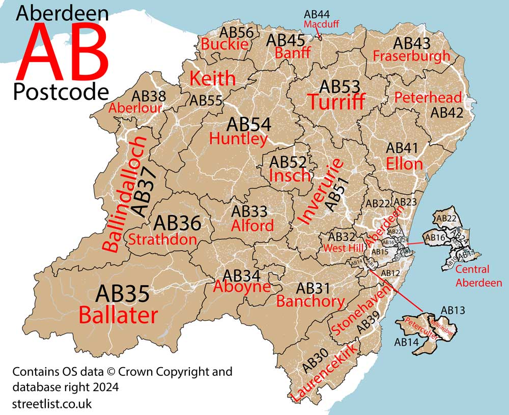
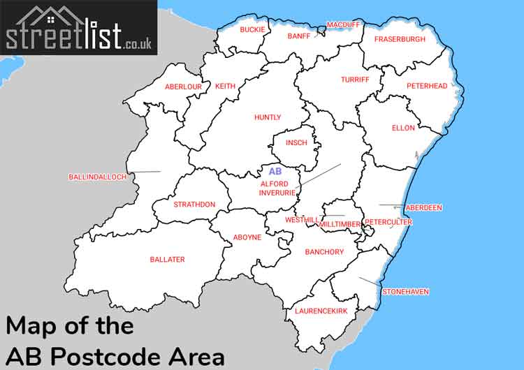
Post Towns and Postcode Districts for the AB Postcode
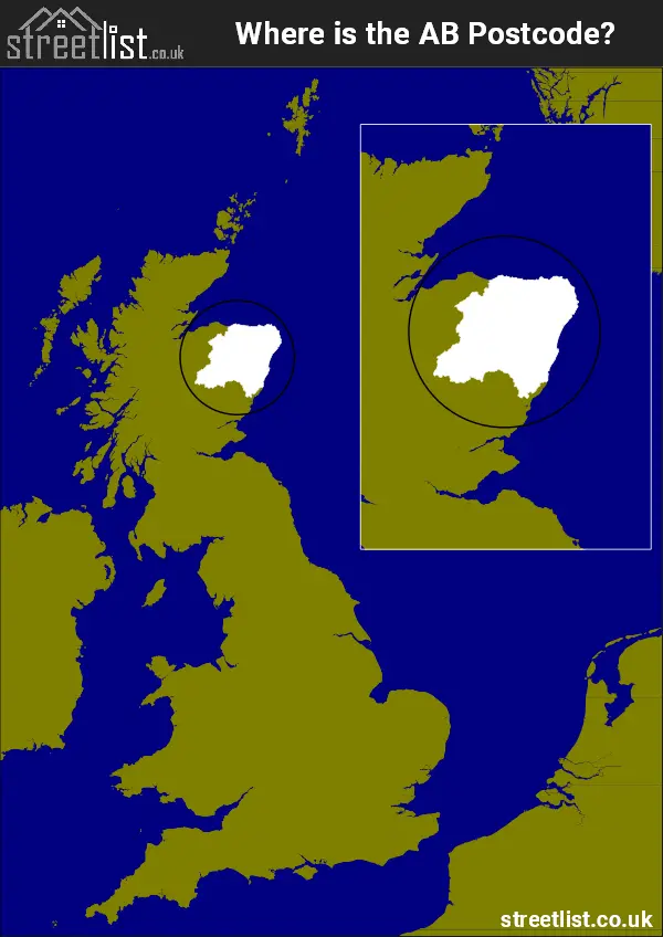
Where is the AB Postcode Area?
The AB postcode area is located on the east coast of Scotland, named after Aberdeen, a coastal city and port. It spans from Buckie in the north to Stonehaven in the south, bordered by the Moray Firth to the north and the North Sea to the east.
The area reaches inland up to the Cairngorms. Positioned about 75 miles northeast of Glasgow and 65 miles northeast of Edinburgh, it is also approximately 375 miles northwest of London and 365 miles north of Cardiff.
The AB Aberdeen Postcode is in Scotland. The postal area borders the following neighbouring postal areas: DD - Dundee, PH - Perth and IV - Inverness, It also borders The North Sea and The Moray Firth.
Postcode Districts within the AB Aberdeen Postcode Area
There are 33 postcode districts within the Aberdeen postcode area
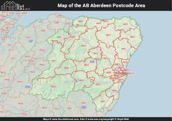
A map showing the boundary of in relation to other areas
Map of the AB Aberdeen Postcode Area
Explore the AB Aberdeen postcode area by using our free interactive map.
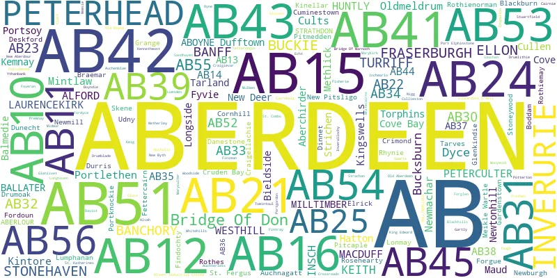
There are 25 towns within the Aberdeen postcode area.
| Unit | Area² |
|---|---|
| Hectares | 7,871,817² |
| Miles | 30,393² |
| Feet | 847,314,510,063² |
| Kilometres | 78,718² |
Postal Delivery Offices serving the AB Aberdeen Postcode Area
- Aberlour Scale Payment Delivery Office
- Aboyne Scale Payment Delivery Office
- Alford Scale Payment Delivery Office
- Altens Delivery Office
- Ballater Scale Payment Delivery Office
- Ballindalloch Scale Payment Delivery Office
- Banchory Delivery Office
- Banff Delivery Office
- Bridge Of Don Delivery Office
- Buckie Delivery Office
- Dyce Delivery Office
- Ellon Delivery Office
- Fraserburgh Delivery Office
- Huntly Delivery Office
- Inverurie Delivery Office
- Keith Delivery Office
- Kittybrewster Delivery Office
- Laurencekirk Delivery Office
- Mastrick Delivery Office
- Peterhead Delivery Office
- Stonehaven Delivery Office
- Turriff Delivery Office
- Westhill Delivery Office
Councils with Postcodes in AB
Towns and Villages within the AB Aberdeen Postcode Area
- Aberchirder - town
- Aberdeen - city
- Aberlour -
- Aboyne - village
- Alford -
- Arbuthnott - village
- Archiestown - village
- Ardo - otherSettlement
- Arradoul - village
- Aucharnie - otherSettlement
- Auchenblae - village
- Auchleven - village
- Auchmaliddie - otherSettlement
- Auchnagatt - village
- Ballater - town
- Balmedie - village
- Balthangie - otherSettlement
- Banchory - town
- Banchory-Devenick - village
- Banff - town
- Bauds of Cullen - otherSettlement
- Belhelvie - village
- Birse - village
- Birsemore - village
- Blackburn (Aberdeenshire) - town
- Blackdog - village
- Blairs - village
- Boddam -
- Bogton - otherSettlement
- Braemar - village
- Brathens - otherSettlement
- Bridge of Alford - village
- Bridge of Gairn - otherSettlement
- Buckie - town
- Cairnie - village
- Cammachmore - village
- Cardhu - village
- Carron - village
- Catterline - village
- Chapel of Garioch - village
- Chapelton - Settlement
- Clochcan - otherSettlement
- Clola - otherSettlement
- Collieston - village
- Cookney - otherSettlement
- Cookston - otherSettlement
- Cornhill - village
- Corsehill - otherSettlement
- Cothal - otherSettlement
- Cove Bay - urban area
- Cowbog - otherSettlement
- Craigellachie - village
- Crathes - village
- Crimond - village
- Crossfields - otherSettlement
- Cruden Bay - village
- Cullen - town
- Cultercullen - village
- Cuminestown - village
- Daviot - village
- Denhead - otherSettlement
- Dinnet - village
- Downies - village
- Drum - otherSettlement
- Drumblade - otherSettlement
- Drumlithie - village
- Drummuir - village
- Drumoak - village
- Dufftown - town
- Dunecht - village
- Dyce -
- Echt - village
- Ellon - town
- Esslemont - otherSettlement
- Fedderate - otherSettlement
- Fetterangus - village
- Fettercairn - village
- Fiddes - otherSettlement
- Fiddler's Green - otherSettlement
- Findochty - town
- Finzean - otherSettlement
- Fordoun - village
- Fordyce - village
- Forgue - village
- Foveran - village
- Fraserburgh - town
- Fyvie - village
- Gardenstown - village
- Garlogie - village
- Gartly - village
- Gight - otherSettlement
- Glassel - otherSettlement
- Glenbervie - otherSettlement
- Glenkindie - village
- Glenlivet - village
- Gordonstown - otherSettlement
- Greens - otherSettlement
- Hardgate - otherSettlement
- Hatton of Cruden -
- Hatton of Fintray - village
- Haugh of Glass - otherSettlement
- Huntly - town
- Inchmarlo - village
- Insch - village
- Inverallochy and Cairnbulg -
- Inverugie - village
- Inverurie - town
- Keig - village
- Keith - town
- Kemnay - village
- Kennethmont - village
- Kiddshill - otherSettlement
- Kildrummy - otherSettlement
- Kincardine O'Neil - village
- Kinellar - village
- Kingseat (Aberdeenshire) -
- Kingswells - village
- Kinmuck - village
- Kinmundy - otherSettlement
- Kinnoir - otherSettlement
- Kintore - town
- Kirkton of Auchterless - village
- Kirkton of Culsalmond - otherSettlement
- Kirkton of Maryculter - village
- Knaven - otherSettlement
- Knock - otherSettlement
- Knockando - village
- Laurencekirk - town
- Lintmill - village
- Logie Coldstone - village
- Longhaven - otherSettlement
- Longside - village
- Lonmay - otherSettlement
- Lumphanan - village
- Lumsden - village
- Luthermuir - village
- Macduff - town
- Marnoch - otherSettlement
- Marykirk - village
- Marypark - village
- Marywell -
- Maud - village
- Meikle Wartle - village
- Memsie - village
- Methlick - village
- Midmar - otherSettlement
- Millbrex - otherSettlement
- Milltimber - village
- Milltown of Rothiemay - village
- Mintlaw - village
- Montgarrie - village
- Monymusk - village
- Muchalls - village
- Muir of Fowlis - village
- Nether Kinmundy - otherSettlement
- Netherbrae - otherSettlement
- Netherley - village
- New Aberdour - village
- New Byth - village
- New Deer - village
- New Leeds - village
- New Pitsligo - village
- Newburgh (Aberdeenshire) -
- Newhills - village
- Newmachar - village
- Newmill - village
- Newtonhill - village
- Old Deer - village
- Old Rayne - village
- Oldmeldrum - town
- Oldwhat - otherSettlement
- Oyne - village
- Peterculter - village
- Peterhead - town
- Pitmedden - village
- Portgordon - village
- Portknockie - village
- Portlethen - town
- Portlethen Village - village
- Portsoy - town
- Potterton -
- Quilquox - otherSettlement
- Rathven - village
- Rhynie - village
- Rora - village
- Rosehearty - town
- Rothes - town
- Rothienorman - village
- Sandend - village
- Sandhaven - village
- Sauchen - village
- Silverhillocks - otherSettlement
- St Combs - village
- St Fergus - village
- Stevensburn - otherSettlement
- Stonehaven - town
- Strachan - village
- Strathdon - otherSettlement
- Strichen - village
- Stuartfield - village
- Tarland - village
- Tarves -
- Tillyfourie - otherSettlement
- Tipperty - village
- Tomintoul - village
- Tomnavoulin - village
- Tornaveen - otherSettlement
- Torphins - village
- Tullynessle - village
- Turriff - town
- Udny Green - village
- Westhill (Aberdeenshire) -
- Whitecairns - otherSettlement
- Whiteford - village
- Whitehills - village
- Woodhead - village
- Woodlands - village
- Ythanbank - village