The AL1 4 postcode sector is within the county of Hertfordshire.
Did you know? According to the 2021 Census, the AL1 4 postcode sector is home to a bustling 9,635 residents!
Given that each sector allows for 400 unique postcode combinations. Letters C, I, K, M, O and V are not allowed in the last two letters of a postcode. With 231 postcodes already in use, this leaves 169 units available.
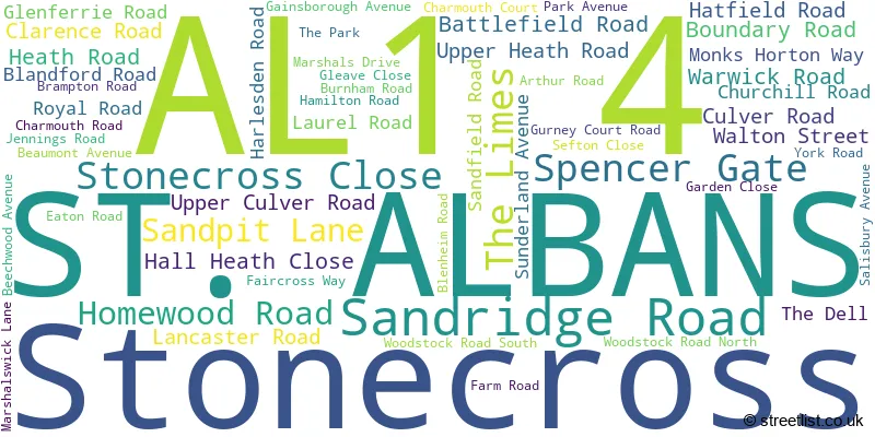
The AL1 4 postal code covers the settlement of ST. ALBANS.
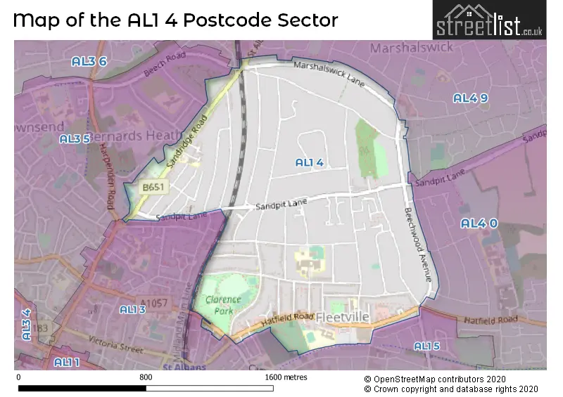
The AL1 4 Postcode shares a border with AL1 3 (ST. ALBANS), AL3 6 (ST. ALBANS, Childwickbury, Gorhambury), AL4 0 (ST. ALBANS, Colney Heath, Smallford), AL4 9 (ST. ALBANS, Sandridge), AL1 5 (ST. ALBANS) and AL3 5 (ST. ALBANS).
The sector is within the post town of ST. ALBANS.
AL1 4 is a postcode sector within the AL1 postcode district which is within the AL St Albans postcode area.
The Royal Mail delivery office for the AL1 4 postal sector is the St. Albans Delivery Office.
The area of the AL1 4 postcode sector is 0.94 square miles which is 2.45 square kilometres or 604.21 square acres.

Map of the AL1 4 Postcode Sector
Explore the AL1 4 postcode sector by using our free interactive map.
| A | L | 1 | - | 4 | X | X |
| A | L | 1 | Space | 4 | Letter | Letter |
Official List of Streets
ST. ALBANS (55 Streets)
Unofficial Streets or Alternative Spellings
ST. ALBANS
ALBION ROAD ASHLEY ROAD BEECH ROAD CASTLE ROAD CAVENDISH ROAD CENTRAL DRIVE CHALKDELL FIELDS CHESTNUT DRIVE ELM DRIVE FURSE AVENUE GRANVILLE ROAD JERSEY LANE MARSHALL AVENUE SEYMOUR ROAD SHERWOOD AVENUE STANHOPE ROAD SUTTON ROAD THE RIDGEWAY VALLEY ROAD ARCHERS FIELDS CHAUCER CLOSE CHURCH PATH CLARENCE PARK MEWS HARPTREE WAY HEATHFIELD COURT HEATHSIDE LUNA PLACE MARSHALS COURT PRESTWOOD GATE QUEENS COURT SNATCHUP ALLEY ST ALBANS ROAD ST JOHNS COURT ST PAULS PLACE WICKWOOD COURTSandridge
RONSONS WAYSmallford
HATFIELD ROADWeather Forecast for AL1 4
Press Button to Show Forecast for St. Albans
| Time Period | Icon | Description | Temperature | Rain Probability | Wind |
|---|---|---|---|---|---|
| 03:00 to 06:00 | Clear night | 3.0°C (feels like 0.0°C) | 0.00% | NNW 9 mph | |
| 06:00 to 09:00 | Cloudy | 4.0°C (feels like 0.0°C) | 3.00% | NNW 9 mph | |
| 09:00 to 12:00 | Cloudy | 7.0°C (feels like 4.0°C) | 8.00% | N 13 mph | |
| 12:00 to 15:00 | Overcast | 9.0°C (feels like 6.0°C) | 8.00% | N 13 mph | |
| 15:00 to 18:00 | Cloudy | 10.0°C (feels like 7.0°C) | 4.00% | N 11 mph | |
| 18:00 to 21:00 | Cloudy | 9.0°C (feels like 6.0°C) | 4.00% | NNE 9 mph | |
| 21:00 to 00:00 | Cloudy | 6.0°C (feels like 4.0°C) | 4.00% | NNE 4 mph |
Press Button to Show Forecast for St. Albans
| Time Period | Icon | Description | Temperature | Rain Probability | Wind |
|---|---|---|---|---|---|
| 00:00 to 03:00 | Partly cloudy (night) | 5.0°C (feels like 3.0°C) | 2.00% | N 4 mph | |
| 03:00 to 06:00 | Partly cloudy (night) | 4.0°C (feels like 1.0°C) | 2.00% | NNW 7 mph | |
| 06:00 to 09:00 | Cloudy | 4.0°C (feels like 2.0°C) | 6.00% | N 7 mph | |
| 09:00 to 12:00 | Overcast | 7.0°C (feels like 4.0°C) | 10.00% | N 11 mph | |
| 12:00 to 15:00 | Overcast | 9.0°C (feels like 6.0°C) | 10.00% | NNE 11 mph | |
| 15:00 to 18:00 | Overcast | 10.0°C (feels like 7.0°C) | 10.00% | NNE 11 mph | |
| 18:00 to 21:00 | Partly cloudy (day) | 8.0°C (feels like 6.0°C) | 3.00% | NNE 11 mph | |
| 21:00 to 00:00 | Partly cloudy (night) | 5.0°C (feels like 3.0°C) | 3.00% | NNE 9 mph |
Press Button to Show Forecast for St. Albans
| Time Period | Icon | Description | Temperature | Rain Probability | Wind |
|---|---|---|---|---|---|
| 00:00 to 03:00 | Partly cloudy (night) | 4.0°C (feels like 2.0°C) | 3.00% | NNE 7 mph | |
| 03:00 to 06:00 | Partly cloudy (night) | 3.0°C (feels like 1.0°C) | 3.00% | N 7 mph | |
| 06:00 to 09:00 | Cloudy | 4.0°C (feels like 1.0°C) | 7.00% | N 7 mph | |
| 09:00 to 12:00 | Cloudy | 7.0°C (feels like 5.0°C) | 10.00% | N 7 mph | |
| 12:00 to 15:00 | Overcast | 8.0°C (feels like 7.0°C) | 17.00% | N 7 mph | |
| 15:00 to 18:00 | Overcast | 9.0°C (feels like 7.0°C) | 17.00% | NNW 7 mph | |
| 18:00 to 21:00 | Overcast | 8.0°C (feels like 6.0°C) | 17.00% | N 7 mph | |
| 21:00 to 00:00 | Cloudy | 6.0°C (feels like 4.0°C) | 14.00% | N 7 mph |
Press Button to Show Forecast for St. Albans
| Time Period | Icon | Description | Temperature | Rain Probability | Wind |
|---|---|---|---|---|---|
| 00:00 to 03:00 | Light rain shower (night) | 5.0°C (feels like 3.0°C) | 30.00% | NNW 4 mph | |
| 03:00 to 06:00 | Cloudy | 4.0°C (feels like 2.0°C) | 12.00% | NNE 4 mph | |
| 06:00 to 09:00 | Cloudy | 5.0°C (feels like 3.0°C) | 11.00% | N 7 mph | |
| 09:00 to 12:00 | Cloudy | 8.0°C (feels like 5.0°C) | 10.00% | NNE 9 mph | |
| 12:00 to 15:00 | Overcast | 9.0°C (feels like 7.0°C) | 13.00% | N 9 mph | |
| 15:00 to 18:00 | Overcast | 10.0°C (feels like 8.0°C) | 17.00% | N 9 mph | |
| 18:00 to 21:00 | Cloudy | 10.0°C (feels like 7.0°C) | 6.00% | NNE 9 mph | |
| 21:00 to 00:00 | Clear night | 6.0°C (feels like 4.0°C) | 2.00% | NNE 7 mph |
Schools and Places of Education Within the AL1 4 Postcode Sector
Bernards Heath Infant and Nursery School
Community school
154 Sandridge Road, St Albans, Hertfordshire, AL1 4AP
Head: Mrs Hannah Rimmer
Ofsted Rating: Good
Inspection: 2022-01-26 (815 days ago)
Website: Visit Bernards Heath Infant and Nursery School Website
Phone: 01727852106
Number of Pupils: 309
Fleetville Infant and Nursery School
Academy converter
Royal Road, St Albans, Hertfordshire, AL1 4LX
Head: Mrs Jennifer Gardner
Ofsted Rating: Outstanding
Inspection: 2023-12-15 (127 days ago)
Website: Visit Fleetville Infant and Nursery School Website
Phone: 01727519221
Number of Pupils: 314
Fleetville Junior School
Academy converter
228 Hatfield Road, St Albans, Hertfordshire, AL1 4LW
Head: Ms Clare Whitehouse
Ofsted Rating: Good
Inspection: 2023-11-22 (150 days ago)
Website: Visit Fleetville Junior School Website
Phone: 01727519224
Number of Pupils: 358
Verulam School
Academy converter
Brampton Road, St Albans, Hertfordshire, AL1 4PR
Head: Miss Julie Richardson
Ofsted Rating: Good
Inspection: 2018-10-10 (2019 days ago)
Website: Visit Verulam School Website
Phone: 01727766100
Number of Pupils: 1066
House Prices in the AL1 4 Postcode Sector
| Type of Property | 2018 Average | 2018 Sales | 2017 Average | 2017 Sales | 2016 Average | 2016 Sales | 2015 Average | 2015 Sales |
|---|---|---|---|---|---|---|---|---|
| Detached | £1,176,944 | 40 | £1,249,789 | 47 | £1,267,471 | 49 | £1,130,763 | 41 |
| Semi-Detached | £874,088 | 40 | £813,262 | 30 | £876,517 | 46 | £674,312 | 36 |
| Terraced | £551,543 | 44 | £560,292 | 47 | £593,243 | 48 | £482,125 | 54 |
| Flats | £340,786 | 21 | £321,375 | 8 | £309,260 | 21 | £299,174 | 22 |
Important Postcodes AL1 4 in the Postcode Sector
AL1 4AP is the postcode for Bernards Heath Infant School, 154 Sandridge Road, and Bernards Heath Infant and Nursery School, 154 Sandridge Road
AL1 4LW is the postcode for Fleetville JM School, 228 Hatfield Road, and Fleetville Junior School, 228 Hatfield Road
AL1 4LX is the postcode for Fleetville Infant and Nursery School, Royal Road, and Fleetville Infant & Nursery School, Royal Road
AL1 4PR is the postcode for NEW SPORTS HALL, Verulam School, Brampton Road, Maths Block, Verulam School, Brampton Road, Music Block, Verulam School, Brampton Road, Sixth Form Block, Verulam School, Brampton Road, and Verulam School, Brampton Road
| The AL1 4 Sector is within these Local Authorities |
|
|---|---|
| The AL1 4 Sector is within these Counties |
|
| The AL1 4 Sector is within these Water Company Areas |
|