The AL10 8 postcode sector is within the county of Hertfordshire.
Did you know? According to the 2021 Census, the AL10 8 postcode sector is home to a bustling 11,449 residents!
Given that each sector allows for 400 unique postcode combinations. Letters C, I, K, M, O and V are not allowed in the last two letters of a postcode. With 248 postcodes already in use, this leaves 152 units available.
The AL10 8 postal code covers the settlement of HATFIELD.
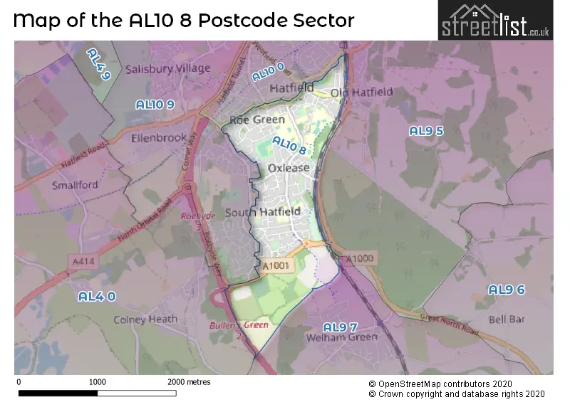
The AL10 8 Postcode shares a border with AL4 0 (ST. ALBANS, Colney Heath, Smallford), AL10 9 (HATFIELD), AL9 5 (HATFIELD, Essendon, North Mymms), AL9 7 (North Mymms, BROOKMANS PARK, WELHAM GREEN) and AL10 0 (HATFIELD).
The sector is within the post town of HATFIELD.
AL10 8 is a postcode sector within the AL10 postcode district which is within the AL St Albans postcode area.
The Royal Mail delivery office for the AL10 8 postal sector is the Hatfield (al) Delivery Office.
The area of the AL10 8 postcode sector is 1.18 square miles which is 3.06 square kilometres or 756.60 square acres.
The AL10 8 postcode sector is crossed by the A1M Major A road.

Map of the AL10 8 Postcode Sector
Explore the AL10 8 postcode sector by using our free interactive map.
| A | L | 1 | 0 | - | 8 | X | X |
| A | L | 1 | 0 | Space | 8 | Letter | Letter |
Official List of Streets
HATFIELD (118 Streets)
Unofficial Streets or Alternative Spellings
HATFIELD
BISHOPS RISE DAYS MEAD ENDYMION MEWS HAZEL GROVE KENNELWOOD LANE LEMSFORD ROAD MEADOW DELL MINSTER CLOSE PEREGRINE WAY QUEENSWAY RESERVOIR COURT ROEHYDE WAY SANDPIPER CLOSE SHALLCROSS CRESCENT WELLFIELD ROAD CAVENDISH WAY CHANTRY LANE DOG KENNEL LANE HOLLIER COURT MCDONALD COURT ROESTOCK ROUNDABOUT TRAVELLERS LANE ROUNDABOUTNorth Mymms
DELLSOME LANEBrookmans Park
GREAT NORTH ROADWeather Forecast for AL10 8
Press Button to Show Forecast for Hatfield (Hertfordshire)
| Time Period | Icon | Description | Temperature | Rain Probability | Wind |
|---|---|---|---|---|---|
| 18:00 to 21:00 | Cloudy | 10.0°C (feels like 8.0°C) | 41.00% | W 11 mph | |
| 21:00 to 00:00 | Light rain | 9.0°C (feels like 6.0°C) | 50.00% | WSW 13 mph |
Press Button to Show Forecast for Hatfield (Hertfordshire)
| Time Period | Icon | Description | Temperature | Rain Probability | Wind |
|---|---|---|---|---|---|
| 00:00 to 03:00 | Cloudy | 9.0°C (feels like 5.0°C) | 51.00% | WSW 13 mph | |
| 03:00 to 06:00 | Light rain | 9.0°C (feels like 6.0°C) | 56.00% | W 13 mph | |
| 06:00 to 09:00 | Cloudy | 9.0°C (feels like 6.0°C) | 39.00% | WNW 11 mph | |
| 09:00 to 12:00 | Cloudy | 11.0°C (feels like 7.0°C) | 49.00% | NW 18 mph | |
| 12:00 to 15:00 | Light rain | 11.0°C (feels like 8.0°C) | 50.00% | NW 16 mph | |
| 15:00 to 18:00 | Light rain | 10.0°C (feels like 8.0°C) | 52.00% | N 11 mph | |
| 18:00 to 21:00 | Cloudy | 9.0°C (feels like 6.0°C) | 51.00% | NNE 9 mph | |
| 21:00 to 00:00 | Cloudy | 7.0°C (feels like 4.0°C) | 7.00% | NNE 9 mph |
Press Button to Show Forecast for Hatfield (Hertfordshire)
| Time Period | Icon | Description | Temperature | Rain Probability | Wind |
|---|---|---|---|---|---|
| 00:00 to 03:00 | Clear night | 5.0°C (feels like 2.0°C) | 1.00% | N 9 mph | |
| 03:00 to 06:00 | Clear night | 4.0°C (feels like 0.0°C) | 2.00% | NNW 9 mph | |
| 06:00 to 09:00 | Cloudy | 4.0°C (feels like 0.0°C) | 5.00% | NNW 9 mph | |
| 09:00 to 12:00 | Overcast | 7.0°C (feels like 3.0°C) | 8.00% | N 11 mph | |
| 12:00 to 15:00 | Overcast | 8.0°C (feels like 6.0°C) | 10.00% | N 11 mph | |
| 15:00 to 18:00 | Overcast | 9.0°C (feels like 7.0°C) | 9.00% | N 11 mph | |
| 18:00 to 21:00 | Cloudy | 8.0°C (feels like 6.0°C) | 5.00% | NNE 9 mph | |
| 21:00 to 00:00 | Clear night | 5.0°C (feels like 3.0°C) | 2.00% | NNE 7 mph |
Press Button to Show Forecast for Hatfield (Hertfordshire)
| Time Period | Icon | Description | Temperature | Rain Probability | Wind |
|---|---|---|---|---|---|
| 00:00 to 03:00 | Clear night | 4.0°C (feels like 2.0°C) | 1.00% | N 4 mph | |
| 03:00 to 06:00 | Partly cloudy (night) | 3.0°C (feels like 1.0°C) | 2.00% | NNW 7 mph | |
| 06:00 to 09:00 | Cloudy | 4.0°C (feels like 2.0°C) | 6.00% | NNW 7 mph | |
| 09:00 to 12:00 | Overcast | 8.0°C (feels like 5.0°C) | 10.00% | N 9 mph | |
| 12:00 to 15:00 | Overcast | 9.0°C (feels like 7.0°C) | 10.00% | NNE 11 mph | |
| 15:00 to 18:00 | Overcast | 10.0°C (feels like 7.0°C) | 11.00% | NNE 11 mph | |
| 18:00 to 21:00 | Cloudy | 9.0°C (feels like 6.0°C) | 5.00% | NNE 11 mph | |
| 21:00 to 00:00 | Clear night | 6.0°C (feels like 3.0°C) | 4.00% | NNE 9 mph |
Press Button to Show Forecast for Hatfield (Hertfordshire)
| Time Period | Icon | Description | Temperature | Rain Probability | Wind |
|---|---|---|---|---|---|
| 00:00 to 03:00 | Clear night | 5.0°C (feels like 2.0°C) | 4.00% | NNE 7 mph | |
| 03:00 to 06:00 | Clear night | 4.0°C (feels like 1.0°C) | 3.00% | NNE 7 mph | |
| 06:00 to 09:00 | Sunny day | 5.0°C (feels like 2.0°C) | 3.00% | N 7 mph | |
| 09:00 to 12:00 | Partly cloudy (day) | 8.0°C (feels like 6.0°C) | 4.00% | NE 11 mph | |
| 12:00 to 15:00 | Cloudy | 10.0°C (feels like 8.0°C) | 9.00% | NE 11 mph | |
| 15:00 to 18:00 | Light rain shower (day) | 10.0°C (feels like 8.0°C) | 29.00% | NE 11 mph | |
| 18:00 to 21:00 | Cloudy | 9.0°C (feels like 6.0°C) | 8.00% | NNE 9 mph | |
| 21:00 to 00:00 | Clear night | 6.0°C (feels like 4.0°C) | 5.00% | NNE 7 mph |
Schools and Places of Education Within the AL10 8 Postcode Sector
Bishop's Hatfield Girls' School
Academy converter
Woods Avenue, Hatfield, Hertfordshire, AL10 8NL
Head: Headteacher Alf Wood
Ofsted Rating: Outstanding
Inspection: 2022-12-07 (498 days ago)
Website: Visit Bishop's Hatfield Girls' School Website
Phone: 01707275331
Number of Pupils: 943
Countess Anne Church of England School
Academy converter
School Lane, Hatfield, Hertfordshire, AL10 8AX
Head: David Lodge
Ofsted Rating: Outstanding
Inspection: 2019-10-16 (1646 days ago)
Website: Visit Countess Anne Church of England School Website
Phone: 01707262840
Number of Pupils: 211
De Havilland Primary School
Academy sponsor led
Travellers Lane, Hatfield, Hertfordshire, AL10 8TQ
Head: Mrs Sarah King
Ofsted Rating: Good
Inspection: 2023-09-20 (211 days ago)
Website: Visit De Havilland Primary School Website
Phone: 01707273542
Number of Pupils: 453
Hatfield Community Free School
Free schools
Briars Lane, Hatfield, Hertfordshire, AL10 8ES
Head: Mrs Victoria Hobson
Ofsted Rating: Outstanding
Inspection: 2014-05-21 (3620 days ago)
Website: Visit Hatfield Community Free School Website
Phone: 01707276018
Number of Pupils: 416
Oak View Primary and Nursery School
Community school
Woods Avenue, Hatfield, Hertfordshire, AL10 8NW
Head: Mr Neil Richardson
Ofsted Rating: Good
Inspection: 2023-06-14 (309 days ago)
Website: Visit Oak View Primary and Nursery School Website
Phone: 01707280590
Number of Pupils: 430
Onslow St Audrey's School
Academy converter
Old Rectory Drive, Hatfield, Hertfordshire, AL10 8AB
Head: Mrs Julie Jones
Ofsted Rating: Good
Inspection: 2023-12-14 (126 days ago)
Website: Visit Onslow St Audrey's School Website
Phone: 01707264228
Number of Pupils: 824
Southfield School
Community special school
Woods Avenue, Hatfield, Hertfordshire, AL10 8NN
Head: Mrs Angela O'Rourke
Ofsted Rating: Good
Inspection: 2019-07-05 (1749 days ago)
Website: Visit Southfield School Website
Phone: 01707276504
Number of Pupils: 85
St Philip Howard Catholic Primary School
Voluntary aided school
Woods Avenue, Hatfield, Hertfordshire, AL10 8NN
Head: Mrs Mairead Waugh
Ofsted Rating: Good
Inspection: 2018-06-26 (2123 days ago)
Website: Visit St Philip Howard Catholic Primary School Website
Phone: 01707263969
Number of Pupils: 481
House Prices in the AL10 8 Postcode Sector
| Type of Property | 2018 Average | 2018 Sales | 2017 Average | 2017 Sales | 2016 Average | 2016 Sales | 2015 Average | 2015 Sales |
|---|---|---|---|---|---|---|---|---|
| Detached | £490,500 | 6 | £470,786 | 7 | £498,143 | 7 | £448,000 | 7 |
| Semi-Detached | £381,889 | 9 | £335,502 | 18 | £380,325 | 12 | £336,000 | 7 |
| Terraced | £293,964 | 73 | £310,404 | 68 | £292,869 | 67 | £249,517 | 84 |
| Flats | £236,929 | 14 | £231,763 | 19 | £200,353 | 17 | £174,737 | 19 |
Important Postcodes AL10 8 in the Postcode Sector
AL10 8AB is the postcode for Onslow St. Audreys School, Old Rectory Drive, and New Science Block, Onslow St. Audreys School, Old Rectory Drive
AL10 8AX is the postcode for Countess Anne School, School Lane, Eden House, Countess Anne (VA) C of E Primary School, School Lane, and Countess Anne (VA) C of E Primary School, School Lane
AL10 8ES is the postcode for Community Free School, Briars Lane
AL10 8HP is the postcode for Burvill House Surgery, 52/54 Dellfield Rd
AL10 8HR is the postcode for Jim McDonald Centre, 3 McDonald Court, and JIM MCDONALD CENTRE, 3 MCDONALD CLOSE
AL10 8NJ is the postcode for H M Revenue & Customs, Gracemead House, Woods Avenue
AL10 8NL is the postcode for Bishops Hatfield Girls School, Woods Avenue
AL10 8NN is the postcode for Southfield School, Woods Avenue, NEW CLASSROOM BLOCK, The St. Philip Howard Catholic Primary School, Woods Avenue, SOUTHFIELD SCHOOL, WOODS AVENUE, HATFIELD, and The St. Philip Howard Catholic Primary School, Woods Avenue
AL10 8NW is the postcode for Oak View Primary & Nursery School, Woods Avenue
AL10 8TJ is the postcode for Links Academy Hatfield, Travellers Lane, Hatfield Leisure Centre, Travellers Lane, and Southfield School, Travellers Lane
AL10 8TP is the postcode for Breaks Manor, Link Drive
AL10 8TQ is the postcode for De Havilland Primary School, Travellers Lane
AL10 8YE is the postcode for The Collonades, Beaconsfield Close
AL10 8YF is the postcode for CENTRAL RESOURCE LIBRARY /TRAINING CENTRE, Herts County Council, New Barn Field, Travellers Lane, SCHOOL LIBRARY SERVICE & HEALTH PROMOTIONS, Herts County Council, New Barn Field, Travellers Lane, and CANTEEN BLOCK, Herts County Council, New Barn Field, Travellers Lane
| The AL10 8 Sector is within these Local Authorities |
|
|---|---|
| The AL10 8 Sector is within these Counties |
|
| The AL10 8 Sector is within these Water Company Areas |
|