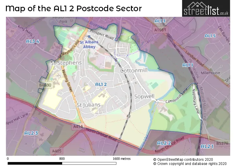
The AL1 2 postcode sector is within the county of Hertfordshire.
Did you know? According to the 2021 Census, the AL1 2 postcode sector is home to a bustling 6,942 residents!
Given that each sector allows for 400 unique postcode combinations. Letters C, I, K, M, O and V are not allowed in the last two letters of a postcode. With 174 postcodes already in use, this leaves 226 units available.
The AL1 2 postal code covers the settlement of ST. ALBANS.
The AL1 2 Postcode shares a border with AL2 2 (PARK STREET, FROGMORE, ST ALBANS), AL2 3 (BRICKET WOOD, CHISWELL GREEN, ST ALBANS), AL1 1 (ST. ALBANS, ST ALBANS) and AL3 4 (ST. ALBANS, Kings Park).
The sector is within the post town of ST. ALBANS.
AL1 2 is a postcode sector within the AL2 postcode district which is within the AL St Albans postcode area.
The Royal Mail delivery office for the AL1 2 postal sector is the St. Albans Delivery Office.
The area of the AL1 2 postcode sector is 1.10 square miles which is 2.84 square kilometres or 700.92 square acres.
The AL1 2 postcode sector is crossed by the A414 Major A road.
Waterways within the AL1 2 postcode sector include the River Ver, Mill Stream.

Map of the AL1 2 Postcode Sector
Explore the AL1 2 postcode sector by using our free interactive map.
| A | L | 1 | - | 2 | X | X |
| A | L | 1 | Space | 2 | Letter | Letter |
Official List of Streets
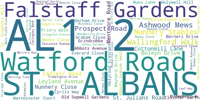
ST. ALBANS (62 Streets)
Unofficial Streets or Alternative Spellings
ST. ALBANS
KING HARRY LANE LEAF WAY MIDWAY MILE HOUSE LANE NAPSBURY LANE NORMAN CLOSE ABBEY VIEW ALBAN WAY BUTTERFIELD DRIVE CENTRIUM CHAPEL CLOSE FERNECROFT GLENGALL PLACE HOLLY CLOSE LECTERN LANE MONKS GATE MUD LANE NORTH ORBITAL OLD OAK PARK STREET ROUNDABOUT PRAETORIAN COURT SAVOY MEWS ST ALBANS CITY FP042 ST ALBANS CITY FP043 ST ALBANS CITY FP044 ST ALBANS CITY FP045 ST ALBANS CITY FP048 ST ALBANS CITY FP049 ST ALBANS CITY FP050 ST ALBANS-HATFIELD BRANCH LINE ST STEPHENS AVENUE THE BRAMBLES THE CLOSE TREVELYAN PLACE VER VALLEY WALK / ST STEPHEN 084 WESTMINSTER LODGEPark Street
WATLING STREETColney Heath
NORTH ORBITAL ROADWeather Forecast for AL1 2
Press Button to Show Forecast for St Albans
| Time Period | Icon | Description | Temperature | Rain Probability | Wind |
|---|---|---|---|---|---|
| 06:00 to 09:00 | Cloudy | 4.0°C (feels like 0.0°C) | 3.00% | NNW 9 mph | |
| 09:00 to 12:00 | Cloudy | 7.0°C (feels like 4.0°C) | 8.00% | N 13 mph | |
| 12:00 to 15:00 | Overcast | 9.0°C (feels like 6.0°C) | 8.00% | N 13 mph | |
| 15:00 to 18:00 | Cloudy | 10.0°C (feels like 7.0°C) | 4.00% | N 11 mph | |
| 18:00 to 21:00 | Cloudy | 9.0°C (feels like 6.0°C) | 4.00% | NNE 9 mph | |
| 21:00 to 00:00 | Cloudy | 6.0°C (feels like 4.0°C) | 4.00% | NNE 4 mph |
Press Button to Show Forecast for St Albans
| Time Period | Icon | Description | Temperature | Rain Probability | Wind |
|---|---|---|---|---|---|
| 00:00 to 03:00 | Partly cloudy (night) | 5.0°C (feels like 3.0°C) | 2.00% | N 4 mph | |
| 03:00 to 06:00 | Partly cloudy (night) | 4.0°C (feels like 1.0°C) | 2.00% | NNW 7 mph | |
| 06:00 to 09:00 | Cloudy | 4.0°C (feels like 2.0°C) | 6.00% | N 7 mph | |
| 09:00 to 12:00 | Overcast | 7.0°C (feels like 4.0°C) | 10.00% | N 11 mph | |
| 12:00 to 15:00 | Overcast | 9.0°C (feels like 6.0°C) | 10.00% | NNE 11 mph | |
| 15:00 to 18:00 | Overcast | 10.0°C (feels like 7.0°C) | 10.00% | NNE 11 mph | |
| 18:00 to 21:00 | Partly cloudy (day) | 8.0°C (feels like 6.0°C) | 3.00% | NNE 11 mph | |
| 21:00 to 00:00 | Partly cloudy (night) | 5.0°C (feels like 3.0°C) | 3.00% | NNE 9 mph |
Press Button to Show Forecast for St Albans
| Time Period | Icon | Description | Temperature | Rain Probability | Wind |
|---|---|---|---|---|---|
| 00:00 to 03:00 | Partly cloudy (night) | 4.0°C (feels like 2.0°C) | 3.00% | NNE 7 mph | |
| 03:00 to 06:00 | Partly cloudy (night) | 3.0°C (feels like 1.0°C) | 3.00% | N 7 mph | |
| 06:00 to 09:00 | Cloudy | 4.0°C (feels like 1.0°C) | 7.00% | N 7 mph | |
| 09:00 to 12:00 | Cloudy | 7.0°C (feels like 5.0°C) | 10.00% | N 7 mph | |
| 12:00 to 15:00 | Overcast | 8.0°C (feels like 7.0°C) | 17.00% | N 7 mph | |
| 15:00 to 18:00 | Overcast | 9.0°C (feels like 7.0°C) | 17.00% | NNW 7 mph | |
| 18:00 to 21:00 | Overcast | 8.0°C (feels like 6.0°C) | 17.00% | N 7 mph | |
| 21:00 to 00:00 | Cloudy | 6.0°C (feels like 4.0°C) | 14.00% | N 7 mph |
Press Button to Show Forecast for St Albans
| Time Period | Icon | Description | Temperature | Rain Probability | Wind |
|---|---|---|---|---|---|
| 00:00 to 03:00 | Light rain shower (night) | 5.0°C (feels like 3.0°C) | 30.00% | NNW 4 mph | |
| 03:00 to 06:00 | Cloudy | 4.0°C (feels like 2.0°C) | 12.00% | NNE 4 mph | |
| 06:00 to 09:00 | Cloudy | 5.0°C (feels like 3.0°C) | 11.00% | N 7 mph | |
| 09:00 to 12:00 | Cloudy | 8.0°C (feels like 5.0°C) | 10.00% | NNE 9 mph | |
| 12:00 to 15:00 | Overcast | 9.0°C (feels like 7.0°C) | 13.00% | N 9 mph | |
| 15:00 to 18:00 | Overcast | 10.0°C (feels like 8.0°C) | 17.00% | N 9 mph | |
| 18:00 to 21:00 | Cloudy | 10.0°C (feels like 7.0°C) | 6.00% | NNE 9 mph | |
| 21:00 to 00:00 | Clear night | 6.0°C (feels like 4.0°C) | 2.00% | NNE 7 mph |
Schools and Places of Education Within the AL1 2 Postcode Sector
Mandeville Primary School
Academy converter
Mandeville Drive, St Albans, Hertfordshire, AL1 2LE
Head: Mrs Cathy Longhurst
Ofsted Rating: Good
Inspection: 2021-10-14 (919 days ago)
Website: Visit Mandeville Primary School Website
Phone: 01727519220
Number of Pupils: 429
St Adrian Roman Catholic Primary School
Voluntary aided school
Watling View, St Albans, Hertfordshire, AL1 2PB
Head: Mrs Aideen Porter
Ofsted Rating: Good
Inspection: 2022-12-15 (492 days ago)
Website: Visit St Adrian Roman Catholic Primary School Website
Phone: 01727852687
Number of Pupils: 219
The Marlborough Science Academy
Academy converter
Watling Street, St Albans, Hertfordshire, AL1 2QA
Head: Ms Annie Thomson
Ofsted Rating: Good
Inspection: 2023-11-30 (142 days ago)
Website: Visit The Marlborough Science Academy Website
Phone: 01727856874
Number of Pupils: 1290
Watling View School
Community special school
Watling View, St Albans, Hertfordshire, AL1 2NU
Head: Mr Andy Scott
Ofsted Rating: Good
Inspection: 2020-03-11 (1501 days ago)
Website: Visit Watling View School Website
Phone: 01727850560
Number of Pupils: 98
House Prices in the AL1 2 Postcode Sector
| Type of Property | 2018 Average | 2018 Sales | 2017 Average | 2017 Sales | 2016 Average | 2016 Sales | 2015 Average | 2015 Sales |
|---|---|---|---|---|---|---|---|---|
| Detached | £900,625 | 12 | £812,333 | 12 | £757,313 | 16 | £715,933 | 15 |
| Semi-Detached | £573,257 | 27 | £548,760 | 31 | £521,320 | 25 | £504,095 | 21 |
| Terraced | £504,117 | 24 | £467,822 | 28 | £419,381 | 24 | £370,515 | 31 |
| Flats | £300,714 | 28 | £330,579 | 19 | £290,506 | 17 | £257,963 | 23 |
Important Postcodes AL1 2 in the Postcode Sector
AL1 2DL is the postcode for Westminster Lodge Leisure Centre, Holywell Hill, and New Westminster Lodge Leisure Centre, Holywell Hill
AL1 2LE is the postcode for Mandeville Primary School, Mandeville Drive
AL1 2NU is the postcode for Watling View School, Watling View
AL1 2PB is the postcode for St. Adrian's Catholic Primary School, Watling View, Vesta Lodge, Watling View, and St. Adrian's RC Primary School & Nursery, Watling View
AL1 2QA is the postcode for THE MARLBOROUGH SCIENCE ACADEMY FRANKLIN/PASCAL, Marlborough School, Watling Street, FRANKLIN/PASCAL, Marlborough School, Watling Street, THE MARLBOROUGH SCIENCE ACADEMY, Marlborough School, Watling Street, and Marlborough School, Watling Street
| The AL1 2 Sector is within these Local Authorities |
|
|---|---|
| The AL1 2 Sector is within these Counties |
|
| The AL1 2 Sector is within these Water Company Areas |
|