The AL2 1 postcode sector is within the county of Hertfordshire.
Did you know? According to the 2021 Census, the AL2 1 postcode sector is home to a bustling 9,815 residents!
Given that each sector allows for 400 unique postcode combinations. Letters C, I, K, M, O and V are not allowed in the last two letters of a postcode. With 249 postcodes already in use, this leaves 151 units available.
The largest settlements in the AL2 1 postal code are LONDON COLNEY and Napsbury.
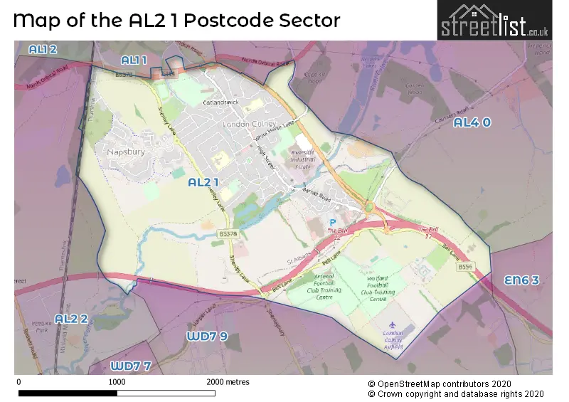
The AL2 1 Postcode shares a border with WD7 9 (SHENLEY ), AL2 2 (PARK STREET, FROGMORE, ST ALBANS), AL4 0 (ST. ALBANS, Colney Heath, Smallford), EN6 3 (POTTERS BAR , SOUTH MIMMS , RIDGE ) and AL1 1 (ST. ALBANS, ST ALBANS).
The sector is within the post town of ST. ALBANS.
AL2 1 is a postcode sector within the AL2 postcode district which is within the AL St Albans postcode area.
The Royal Mail delivery office for the AL2 1 postal sector is the St. Albans Delivery Office.
The area of the AL2 1 postcode sector is 3.02 square miles which is 7.83 square kilometres or 1,933.76 square acres.
The AL2 1 postcode sector is crossed by the M25 motorway.
Waterways within the AL2 1 postcode sector include the River Colne.

Map of the AL2 1 Postcode Sector
Explore the AL2 1 postcode sector by using our free interactive map.
| A | L | 2 | - | 1 | X | X |
| A | L | 2 | Space | 1 | Letter | Letter |
Official List of Streets
London Colney (81 Streets)
ST. ALBANS (3 Streets)
Napsbury (3 Streets)
Unofficial Streets or Alternative Spellings
London Colney
MILLFIELD CLOSE ARMSTRONG CLOSE BANFIELD COURT CHICKEN LANE COLNEY FIELDS FIELDFARES FOXHOLLOWS KINGFISHER MEWS KINGS COURT LONDON COLNEY ROUNDABOUT MOUNT VIEW PARK HOMES RIDGEVIEW SIDING WAY THE BELL ROUNDABOUT WATERSPLASH COURT WATERY LANE WATLING CHASE TRAILColney Heath
COURSERS ROAD NORTH ORBITAL ROADTyttenhanger
HIGHFIELD LANEShenley
HARPER LANE SHENLEYBURYWeather Forecast for AL2 1
Press Button to Show Forecast for Radlett
| Time Period | Icon | Description | Temperature | Rain Probability | Wind |
|---|---|---|---|---|---|
| 21:00 to 00:00 | Cloudy | 6.0°C (feels like 4.0°C) | 7.00% | NE 7 mph |
Press Button to Show Forecast for Radlett
| Time Period | Icon | Description | Temperature | Rain Probability | Wind |
|---|---|---|---|---|---|
| 00:00 to 03:00 | Cloudy | 5.0°C (feels like 3.0°C) | 4.00% | NE 4 mph | |
| 03:00 to 06:00 | Partly cloudy (night) | 3.0°C (feels like 1.0°C) | 4.00% | NE 4 mph | |
| 06:00 to 09:00 | Partly cloudy (day) | 3.0°C (feels like 1.0°C) | 2.00% | NE 7 mph | |
| 09:00 to 12:00 | Partly cloudy (day) | 7.0°C (feels like 5.0°C) | 2.00% | ENE 7 mph | |
| 12:00 to 15:00 | Cloudy | 10.0°C (feels like 9.0°C) | 10.00% | ENE 7 mph | |
| 15:00 to 18:00 | Overcast | 10.0°C (feels like 9.0°C) | 14.00% | ENE 4 mph | |
| 18:00 to 21:00 | Cloudy | 9.0°C (feels like 8.0°C) | 13.00% | ENE 7 mph | |
| 21:00 to 00:00 | Cloudy | 6.0°C (feels like 5.0°C) | 11.00% | E 7 mph |
Press Button to Show Forecast for Radlett
| Time Period | Icon | Description | Temperature | Rain Probability | Wind |
|---|---|---|---|---|---|
| 00:00 to 03:00 | Cloudy | 5.0°C (feels like 2.0°C) | 10.00% | ENE 7 mph | |
| 03:00 to 06:00 | Cloudy | 4.0°C (feels like 2.0°C) | 16.00% | NE 7 mph | |
| 06:00 to 09:00 | Cloudy | 5.0°C (feels like 2.0°C) | 22.00% | NE 7 mph | |
| 09:00 to 12:00 | Overcast | 9.0°C (feels like 6.0°C) | 20.00% | ENE 9 mph | |
| 12:00 to 15:00 | Overcast | 11.0°C (feels like 9.0°C) | 18.00% | E 9 mph | |
| 15:00 to 18:00 | Cloudy | 12.0°C (feels like 10.0°C) | 19.00% | ENE 11 mph | |
| 18:00 to 21:00 | Cloudy | 11.0°C (feels like 8.0°C) | 22.00% | ENE 9 mph | |
| 21:00 to 00:00 | Light rain | 9.0°C (feels like 6.0°C) | 52.00% | NE 11 mph |
Press Button to Show Forecast for Radlett
| Time Period | Icon | Description | Temperature | Rain Probability | Wind |
|---|---|---|---|---|---|
| 00:00 to 03:00 | Heavy rain | 8.0°C (feels like 6.0°C) | 75.00% | NE 9 mph | |
| 03:00 to 06:00 | Heavy rain | 9.0°C (feels like 7.0°C) | 75.00% | E 7 mph | |
| 06:00 to 09:00 | Light rain shower (day) | 9.0°C (feels like 7.0°C) | 44.00% | SE 9 mph | |
| 09:00 to 12:00 | Heavy rain shower (day) | 10.0°C (feels like 8.0°C) | 60.00% | ESE 9 mph | |
| 12:00 to 15:00 | Light rain | 11.0°C (feels like 10.0°C) | 57.00% | SSE 9 mph | |
| 15:00 to 18:00 | Heavy rain shower (day) | 13.0°C (feels like 11.0°C) | 56.00% | SSW 11 mph | |
| 18:00 to 21:00 | Cloudy | 11.0°C (feels like 9.0°C) | 18.00% | WSW 11 mph | |
| 21:00 to 00:00 | Cloudy | 9.0°C (feels like 7.0°C) | 8.00% | SW 7 mph |
Schools and Places of Education Within the AL2 1 Postcode Sector
Bowmansgreen Primary School
Community school
Telford Road, St Albans, Hertfordshire, AL2 1PH
Head: Ms Anna Lippa
Ofsted Rating: Good
Inspection: 2019-11-13 (1625 days ago)
Website: Visit Bowmansgreen Primary School Website
Phone: 01727767772
Number of Pupils: 339
London Colney Primary & Nursery School
Community school
Alexander Road, St Albans, Hertfordshire, AL2 1JG
Head: Mrs Sarah Joyce
Ofsted Rating: Good
Inspection: 2023-03-03 (419 days ago)
Website: Visit London Colney Primary & Nursery School Website
Phone: 01727823283
Number of Pupils: 187
Saint Bernadette Catholic Primary School
Voluntary aided school
Walsingham Way, St Albans, Hertfordshire, AL2 1NL
Head: Co Headteacher Sandra Lavelle-Murphy / Jodie Reilly
Ofsted Rating: Good
Inspection: 2018-10-10 (2024 days ago)
Website: Visit Saint Bernadette Catholic Primary School Website
Phone: 01727822489
Number of Pupils: 216
House Prices in the AL2 1 Postcode Sector
| Type of Property | 2018 Average | 2018 Sales | 2017 Average | 2017 Sales | 2016 Average | 2016 Sales | 2015 Average | 2015 Sales |
|---|---|---|---|---|---|---|---|---|
| Detached | £634,500 | 15 | £740,679 | 14 | £644,667 | 12 | £703,125 | 16 |
| Semi-Detached | £461,736 | 36 | £444,644 | 17 | £422,196 | 23 | £387,821 | 34 |
| Terraced | £429,677 | 45 | £457,704 | 51 | £427,442 | 61 | £355,769 | 62 |
| Flats | £272,137 | 47 | £282,150 | 39 | £277,364 | 82 | £245,750 | 81 |
Important Postcodes AL2 1 in the Postcode Sector
AL2 1BZ is the postcode for PAVILION, Shenley Athletic Ground, Bell Lane, and CHANGING FACILITIES, Shenley Athletic Ground, Bell Lane
AL2 1EB is the postcode for Cotlandswick Leisure Centre, 341 High Street
AL2 1EU is the postcode for The Village Surgery, 283 High Street
AL2 1JG is the postcode for LONDON COLNEY PRIMARY AND NURSERY SCHOOL, Alexander Road, and London Colney Primary & Nursery School, Alexander Road
AL2 1LB is the postcode for Adventure World Recreation Centre, Perham Way
AL2 1NL is the postcode for St. Bernadette Catholic Primary School, Walsingham Way, London Colney, and St. Bernadette Catholic Primary School - London Colney, Walsingham Way
AL2 1PH is the postcode for BOWMANSGREEN PRIMARY SCHOOL, TELFORD ROAD, LONDON COLNEY, and Bowmansgreen Primary School, Telford Road
| The AL2 1 Sector is within these Local Authorities |
|
|---|---|
| The AL2 1 Sector is within these Counties |
|
| The AL2 1 Sector is within these Water Company Areas |
|
Tourist Attractions within the AL2 1 Postcode Area
We found 1 visitor attractions within the AL2 postcode area
| de Havilland Aircraft Heritage Centre |
|---|
| Museums & Art Galleries |
| Museum and / or Art Gallery |
| View de Havilland Aircraft Heritage Centre on Google Maps |