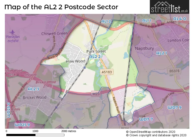
The AL2 2 postcode sector is within the county of Hertfordshire.
Did you know? According to the 2021 Census, the AL2 2 postcode sector is home to a bustling 6,122 residents!
Given that each sector allows for 400 unique postcode combinations. Letters C, I, K, M, O and V are not allowed in the last two letters of a postcode. With 208 postcodes already in use, this leaves 192 units available.
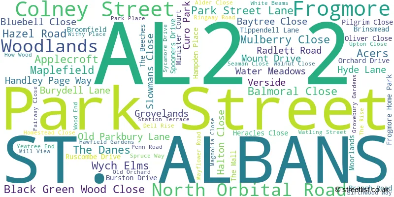
The largest settlement in the AL2 2 postal code is PARK STREET followed by FROGMORE, and ST ALBANS.
The AL2 2 Postcode shares a border with WD7 7 (RADLETT , SHENLEY ), WD7 9 (SHENLEY ), AL2 3 (BRICKET WOOD, CHISWELL GREEN, ST ALBANS), AL1 1 (ST. ALBANS, ST ALBANS), AL1 2 (ST. ALBANS) and AL2 1 (LONDON COLNEY, Napsbury).
The sector is within the post town of ST. ALBANS.
AL2 2 is a postcode sector within the AL2 postcode district which is within the AL St Albans postcode area.
The Royal Mail delivery office for the AL2 2 postal sector is the St. Albans Delivery Office.
The area of the AL2 2 postcode sector is 2.80 square miles which is 7.24 square kilometres or 1,790.22 square acres.
The AL2 2 postcode sector is crossed by the M25 motorway.
Waterways within the AL2 2 postcode sector include the River Ver, River Colne.

Map of the AL2 2 Postcode Sector
Explore the AL2 2 postcode sector by using our free interactive map.
| A | L | 2 | - | 2 | X | X |
| A | L | 2 | Space | 2 | Letter | Letter |
Official List of Streets
Park Street (58 Streets)
Frogmore (7 Streets)
ST. ALBANS (6 Streets)
Unofficial Streets or Alternative Spellings
Park Street
HERACLES CLOSEST. ALBANS
DRIFTWOOD AVENUE MANOR DRIVE PENMAN CLOSE WILLOW WAY ALBANY MEWS AVIAN AVENUE BENINGFIELD DRIVE CARDINAL PLACE CENTAURUS SQUARE DARLEY CROFT FAIRHAVEN FREDERICK PLACE GIDIAN COURT HARBERT GARDENS HEYFORD END INGLEWOOD GARDENS JAKES VIEW NORTH ORBITAL PAGE PLACE PARK INDUSTRIAL ESTATE PARK STREET ROUNDABOUT ST ALBANS CITY FP049 ST ALBANS CITY FP050 ST STEPHEN 085 ST STEPHEN UCR3 VENTURA PARK VER VALLEY WALK / ST STEPHEN 084 VER VALLEY WALK / ST STEPHEN FP084 VICTOR WAY WOODCUTTER PLACERADLETT
WATLING STREETColney Heath
NORTH ORBITAL ROADColney Street
MOOR MILL LANEBricket Wood
LYE LANE SMUG OAK LANEWeather Forecast for AL2 2
Press Button to Show Forecast for Chiswell Green
| Time Period | Icon | Description | Temperature | Rain Probability | Wind |
|---|---|---|---|---|---|
| 09:00 to 12:00 | Cloudy | 7.0°C (feels like 4.0°C) | 4.00% | NNW 11 mph | |
| 12:00 to 15:00 | Cloudy | 9.0°C (feels like 7.0°C) | 3.00% | N 11 mph | |
| 15:00 to 18:00 | Cloudy | 10.0°C (feels like 8.0°C) | 4.00% | N 9 mph | |
| 18:00 to 21:00 | Partly cloudy (day) | 9.0°C (feels like 7.0°C) | 1.00% | N 7 mph | |
| 21:00 to 00:00 | Partly cloudy (night) | 6.0°C (feels like 5.0°C) | 1.00% | ENE 4 mph |
Press Button to Show Forecast for Chiswell Green
| Time Period | Icon | Description | Temperature | Rain Probability | Wind |
|---|---|---|---|---|---|
| 00:00 to 03:00 | Cloudy | 5.0°C (feels like 3.0°C) | 4.00% | SSW 4 mph | |
| 03:00 to 06:00 | Cloudy | 4.0°C (feels like 1.0°C) | 4.00% | WSW 4 mph | |
| 06:00 to 09:00 | Cloudy | 4.0°C (feels like 2.0°C) | 5.00% | W 7 mph | |
| 09:00 to 12:00 | Cloudy | 8.0°C (feels like 6.0°C) | 8.00% | WNW 9 mph | |
| 12:00 to 15:00 | Overcast | 9.0°C (feels like 7.0°C) | 16.00% | WNW 9 mph | |
| 15:00 to 18:00 | Overcast | 10.0°C (feels like 8.0°C) | 14.00% | WNW 7 mph | |
| 18:00 to 21:00 | Cloudy | 9.0°C (feels like 8.0°C) | 12.00% | NW 4 mph | |
| 21:00 to 00:00 | Cloudy | 7.0°C (feels like 5.0°C) | 7.00% | N 4 mph |
Press Button to Show Forecast for Chiswell Green
| Time Period | Icon | Description | Temperature | Rain Probability | Wind |
|---|---|---|---|---|---|
| 00:00 to 03:00 | Cloudy | 5.0°C (feels like 3.0°C) | 6.00% | NNW 4 mph | |
| 03:00 to 06:00 | Cloudy | 4.0°C (feels like 2.0°C) | 6.00% | NNE 4 mph | |
| 06:00 to 09:00 | Cloudy | 4.0°C (feels like 2.0°C) | 10.00% | ENE 4 mph | |
| 09:00 to 12:00 | Cloudy | 7.0°C (feels like 6.0°C) | 12.00% | E 7 mph | |
| 12:00 to 15:00 | Overcast | 10.0°C (feels like 8.0°C) | 19.00% | SE 7 mph | |
| 15:00 to 18:00 | Overcast | 10.0°C (feels like 9.0°C) | 21.00% | ESE 7 mph | |
| 18:00 to 21:00 | Cloudy | 9.0°C (feels like 8.0°C) | 19.00% | SE 9 mph | |
| 21:00 to 00:00 | Cloudy | 8.0°C (feels like 5.0°C) | 16.00% | ESE 7 mph |
Press Button to Show Forecast for Chiswell Green
| Time Period | Icon | Description | Temperature | Rain Probability | Wind |
|---|---|---|---|---|---|
| 00:00 to 03:00 | Cloudy | 7.0°C (feels like 5.0°C) | 21.00% | ESE 7 mph | |
| 03:00 to 06:00 | Light rain | 6.0°C (feels like 5.0°C) | 48.00% | E 7 mph | |
| 06:00 to 09:00 | Light rain | 7.0°C (feels like 5.0°C) | 49.00% | E 7 mph | |
| 09:00 to 12:00 | Cloudy | 9.0°C (feels like 8.0°C) | 19.00% | SE 7 mph | |
| 12:00 to 15:00 | Light rain | 11.0°C (feels like 9.0°C) | 44.00% | SE 9 mph | |
| 15:00 to 18:00 | Light rain shower (day) | 11.0°C (feels like 10.0°C) | 43.00% | SE 9 mph | |
| 18:00 to 21:00 | Light rain shower (day) | 11.0°C (feels like 9.0°C) | 39.00% | ENE 7 mph | |
| 21:00 to 00:00 | Cloudy | 10.0°C (feels like 8.0°C) | 22.00% | E 7 mph |
Schools and Places of Education Within the AL2 2 Postcode Sector
How Wood Primary and Nursery School
Community school
Spooners Drive, St Albans, Hertfordshire, AL2 2HU
Head: Mrs CYNTHIA ROWE
Ofsted Rating: Good
Inspection: 2023-03-03 (418 days ago)
Website: Visit How Wood Primary and Nursery School Website
Phone: 01727768885
Number of Pupils: 220
Park Street Church of England Voluntary Aided Primary School
Voluntary aided school
Branch Road, St Albans, Hertfordshire, AL2 2LX
Head: Ms Monique Gregory
Ofsted Rating: Good
Inspection: 2021-11-26 (880 days ago)
Website: Visit Park Street Church of England Voluntary Aided Primary School Website
Phone: 01727872158
Number of Pupils: 138
House Prices in the AL2 2 Postcode Sector
| Type of Property | 2018 Average | 2018 Sales | 2017 Average | 2017 Sales | 2016 Average | 2016 Sales | 2015 Average | 2015 Sales |
|---|---|---|---|---|---|---|---|---|
| Detached | £597,624 | 25 | £701,813 | 32 | £610,073 | 34 | £575,198 | 30 |
| Semi-Detached | £519,820 | 19 | £516,563 | 16 | £502,474 | 21 | £466,607 | 28 |
| Terraced | £480,333 | 15 | £408,150 | 20 | £442,283 | 15 | £353,239 | 23 |
| Flats | £239,417 | 12 | £241,856 | 16 | £274,985 | 17 | £238,688 | 16 |
Important Postcodes AL2 2 in the Postcode Sector
AL2 2DQ is the postcode for Unit 8, Handley Page Way, Colney Street
AL2 2HU is the postcode for How Wood Primary School and Nursery, Spooners Drive, Park Street, and How Wood Primary School and Nursery, Spooners Drive
AL2 2LX is the postcode for Park Street C of E VA Primary School & Nursery, Branch Road, Park Street C of E VA Primary School & Nursery, Branch Road, Park Street, and Park Street C Of E Primary School And Nursery, Branch Road, Park Street
| The AL2 2 Sector is within these Local Authorities |
|
|---|---|
| The AL2 2 Sector is within these Counties |
|
| The AL2 2 Sector is within these Water Company Areas |
|