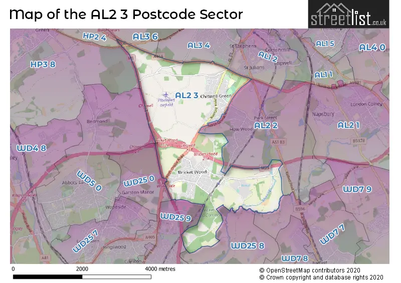
The AL2 3 postcode sector is within the county of Hertfordshire.
Did you know? According to the 2021 Census, the AL2 3 postcode sector is home to a bustling 8,274 residents!
Given that each sector allows for 400 unique postcode combinations. Letters C, I, K, M, O and V are not allowed in the last two letters of a postcode. With 267 postcodes already in use, this leaves 133 units available.
The largest settlement in the AL2 3 postal code is BRICKET WOOD followed by CHISWELL GREEN, and ST ALBANS.
The AL2 3 Postcode shares a border with WD7 7 (RADLETT , SHENLEY ), WD5 0 (ABBOTS LANGLEY , BEDMOND ), AL2 2 (PARK STREET, FROGMORE, ST ALBANS), AL3 6 (ST. ALBANS, Childwickbury, Gorhambury), HP2 4 (HEMEL HEMPSTEAD, Paradise Industrial Estate), WD25 0 (WATFORD , ABBOTS LANGLEY ), WD25 8 (ALDENHAM , WATFORD , LETCHMORE HEATH ), WD25 9 (WATFORD , GARSTON ), AL1 2 (ST. ALBANS), AL3 4 (ST. ALBANS, Kings Park) and HP3 8 (HEMEL HEMPSTEAD, NASH MILLS, Pimlico).
The sector is within the post town of ST. ALBANS.
AL2 3 is a postcode sector within the AL2 postcode district which is within the AL St Albans postcode area.
The Royal Mail delivery office for the AL2 3 postal sector is the St. Albans Delivery Office.
The area of the AL2 3 postcode sector is 4.71 square miles which is 12.20 square kilometres or 3,014.25 square acres.
The AL2 3 postcode sector is crossed by the A414 Major A road.
The AL2 3 postcode sector is crossed by the A405 Major A road.
The AL2 3 postcode sector is crossed by the M1 motorway.
The AL2 3 postcode sector is crossed by the M25 motorway.
Waterways within the AL2 3 postcode sector include the River Ver, River Colne.

Map of the AL2 3 Postcode Sector
Explore the AL2 3 postcode sector by using our free interactive map.
| A | L | 2 | - | 3 | X | X |
| A | L | 2 | Space | 3 | Letter | Letter |
Official List of Streets
Potters Crouch (1 Streets)
Bricket Wood (72 Streets)
ST. ALBANS (37 Streets)
Colney Street (2 Streets)
Unofficial Streets or Alternative Spellings
Park Street
PARK STREET LANE TIPPENDELL LANEHEMEL HEMPSTEAD,
HEMEL HEMPSTEAD ROADBricket Wood
HANCROSS CLOSE JAYS CLOSE RANDALLS WALKColney Heath
NORTH ORBITAL ROADWATFORD
CHEQUERS LANEWeather Forecast for AL2 3
Press Button to Show Forecast for Chiswell Green
| Time Period | Icon | Description | Temperature | Rain Probability | Wind |
|---|---|---|---|---|---|
| 18:00 to 21:00 | Cloudy | 8.0°C (feels like 6.0°C) | 8.00% | NNE 7 mph | |
| 21:00 to 00:00 | Cloudy | 7.0°C (feels like 5.0°C) | 4.00% | ENE 4 mph |
Press Button to Show Forecast for Chiswell Green
| Time Period | Icon | Description | Temperature | Rain Probability | Wind |
|---|---|---|---|---|---|
| 00:00 to 03:00 | Cloudy | 5.0°C (feels like 4.0°C) | 4.00% | NE 4 mph | |
| 03:00 to 06:00 | Cloudy | 4.0°C (feels like 2.0°C) | 4.00% | ENE 4 mph | |
| 06:00 to 09:00 | Cloudy | 4.0°C (feels like 2.0°C) | 5.00% | NE 4 mph | |
| 09:00 to 12:00 | Cloudy | 7.0°C (feels like 5.0°C) | 6.00% | ENE 7 mph | |
| 12:00 to 15:00 | Overcast | 9.0°C (feels like 8.0°C) | 10.00% | E 7 mph | |
| 15:00 to 18:00 | Overcast | 10.0°C (feels like 9.0°C) | 15.00% | E 7 mph | |
| 18:00 to 21:00 | Overcast | 9.0°C (feels like 7.0°C) | 16.00% | E 7 mph | |
| 21:00 to 00:00 | Cloudy | 7.0°C (feels like 5.0°C) | 12.00% | E 7 mph |
Press Button to Show Forecast for Chiswell Green
| Time Period | Icon | Description | Temperature | Rain Probability | Wind |
|---|---|---|---|---|---|
| 00:00 to 03:00 | Cloudy | 6.0°C (feels like 4.0°C) | 11.00% | ENE 7 mph | |
| 03:00 to 06:00 | Cloudy | 5.0°C (feels like 3.0°C) | 16.00% | ENE 7 mph | |
| 06:00 to 09:00 | Light rain | 6.0°C (feels like 3.0°C) | 51.00% | ENE 9 mph | |
| 09:00 to 12:00 | Overcast | 8.0°C (feels like 6.0°C) | 21.00% | ENE 9 mph | |
| 12:00 to 15:00 | Cloudy | 11.0°C (feels like 8.0°C) | 17.00% | E 9 mph | |
| 15:00 to 18:00 | Cloudy | 12.0°C (feels like 10.0°C) | 21.00% | E 9 mph | |
| 18:00 to 21:00 | Light rain | 11.0°C (feels like 9.0°C) | 52.00% | ENE 9 mph | |
| 21:00 to 00:00 | Light rain | 9.0°C (feels like 7.0°C) | 50.00% | ENE 9 mph |
Press Button to Show Forecast for Chiswell Green
| Time Period | Icon | Description | Temperature | Rain Probability | Wind |
|---|---|---|---|---|---|
| 00:00 to 03:00 | Heavy rain | 9.0°C (feels like 6.0°C) | 72.00% | ENE 9 mph | |
| 03:00 to 06:00 | Heavy rain | 8.0°C (feels like 6.0°C) | 73.00% | ENE 9 mph | |
| 06:00 to 09:00 | Heavy rain | 8.0°C (feels like 6.0°C) | 75.00% | ESE 9 mph | |
| 09:00 to 12:00 | Heavy rain shower (day) | 10.0°C (feels like 8.0°C) | 62.00% | ESE 9 mph | |
| 12:00 to 15:00 | Light rain | 12.0°C (feels like 10.0°C) | 54.00% | ESE 11 mph | |
| 15:00 to 18:00 | Heavy rain shower (day) | 12.0°C (feels like 10.0°C) | 61.00% | S 11 mph | |
| 18:00 to 21:00 | Light rain shower (day) | 12.0°C (feels like 10.0°C) | 37.00% | SW 9 mph | |
| 21:00 to 00:00 | Partly cloudy (night) | 10.0°C (feels like 8.0°C) | 5.00% | S 7 mph |
Schools and Places of Education Within the AL2 3 Postcode Sector
Killigrew Primary and Nursery School
Community school
West Avenue, St Albans, Hertfordshire, AL2 3HD
Head: Miss Tracy Mylotte
Ofsted Rating: Good
Inspection: 2018-07-03 (2123 days ago)
Website: Visit Killigrew Primary and Nursery School Website
Phone: 01727774200
Number of Pupils: 390
Mount Pleasant Lane Primary School
Academy converter
Mount Pleasant Lane, St Albans, Hertfordshire, AL2 3XA
Head: Mrs Leanne Williams
Ofsted Rating: Good
Inspection: 2022-10-05 (568 days ago)
Website: Visit Mount Pleasant Lane Primary School Website
Phone: 01923672729
Number of Pupils: 270
House Prices in the AL2 3 Postcode Sector
| Type of Property | 2018 Average | 2018 Sales | 2017 Average | 2017 Sales | 2016 Average | 2016 Sales | 2015 Average | 2015 Sales |
|---|---|---|---|---|---|---|---|---|
| Detached | £676,694 | 45 | £706,619 | 42 | £655,826 | 52 | £641,048 | 66 |
| Semi-Detached | £570,689 | 37 | £559,167 | 36 | £565,568 | 36 | £513,124 | 56 |
| Terraced | £514,429 | 21 | £406,000 | 4 | £424,150 | 10 | £382,045 | 11 |
| Flats | £306,583 | 12 | £250,575 | 12 | £259,760 | 15 | £211,728 | 23 |
Important Postcodes AL2 3 in the Postcode Sector
AL2 3HD is the postcode for LOWER BUILDING, Killigrew Primary and Nursery School, West Avenue, and UPPER BUILDING, Killigrew Primary and Nursery School, West Avenue
AL2 3HW is the postcode for Greenwood Park Community Centre, 37 Tippendell Lane
AL2 3JX is the postcode for Doctors Surgery, 93 Watford Road
AL2 3PJ is the postcode for St. Stephens Parish Centre, Station Road
AL2 3XA is the postcode for Mount Pleasant Lane School, Mount Pleasant Lane, and Mount Pleasant Lane Primary School, Mount Pleasant Lane, Bricket Wood
| The AL2 3 Sector is within these Local Authorities |
|
|---|---|
| The AL2 3 Sector is within these Counties |
|
| The AL2 3 Sector is within these Water Company Areas |
|