The AL3 4 postcode sector is within the county of Hertfordshire.
Did you know? According to the 2021 Census, the AL3 4 postcode sector is home to a bustling 6,219 residents!
Given that each sector allows for 400 unique postcode combinations. Letters C, I, K, M, O and V are not allowed in the last two letters of a postcode. With 185 postcodes already in use, this leaves 215 units available.
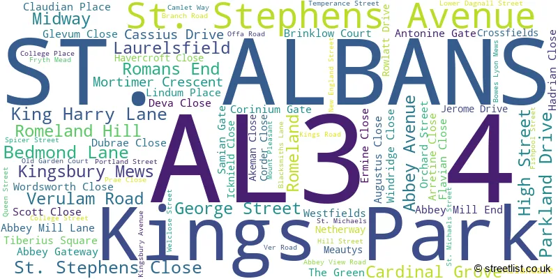
The largest settlements in the AL3 4 postal code are ST. ALBANS and Kings Park.
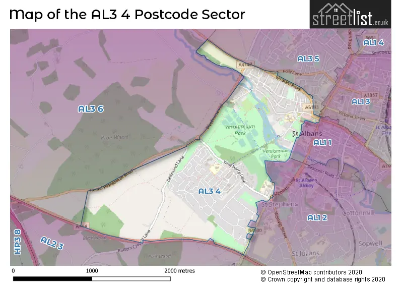
The AL3 4 Postcode shares a border with AL1 3 (ST. ALBANS), AL2 3 (BRICKET WOOD, CHISWELL GREEN, ST ALBANS), AL3 6 (ST. ALBANS, Childwickbury, Gorhambury), AL1 1 (ST. ALBANS, ST ALBANS), AL1 2 (ST. ALBANS) and AL3 5 (ST. ALBANS).
The sector is within the post town of ST. ALBANS.
AL3 4 is a postcode sector within the AL3 postcode district which is within the AL St Albans postcode area.
The Royal Mail delivery office for the AL3 4 postal sector is the St. Albans Delivery Office.
The area of the AL3 4 postcode sector is 1.36 square miles which is 3.51 square kilometres or 868.26 square acres.
The AL3 4 postcode sector is crossed by the A414 Major A road.
Waterways within the AL3 4 postcode sector include the River Ver.

Map of the AL3 4 Postcode Sector
Explore the AL3 4 postcode sector by using our free interactive map.
| A | L | 3 | - | 4 | X | X |
| A | L | 3 | Space | 4 | Letter | Letter |
Official List of Streets
ST. ALBANS (72 Streets)
Unofficial Streets or Alternative Spellings
ST. ALBANS
BRITTON AVENUE CHEQUER STREET CHRISTOPHER PLACE CHURCH CRESCENT FOLLY LANE FRENCH ROW HOLYWELL HILL LONDON ROAD MARKET PLACE REDBOURN ROAD ROBERT AVENUE SPENCER STREET UPPER DAGNALL STREET WATFORD ROAD AQUIS COURT BATCHWOOD ROUNDABOUT BLUEHOUSE HILL BOOT ALLEY CAELIAN PLACE COLLEGE YARD GLENALMOND AND CATHEDRAL COURT GOMBARDS ALLEY HERITAGE CLOSE HOLLYWELL MEWS KING HARRY PARK KINGSGATE KNIGHTS ORCHARD LADY SPENCERS GROVE LAURELS CLOSE MAYNE AVENUE MONASTERY CLOSE MUD LANE PARKLANDS DRIVE POTTERSCROUCH LANE SPINNEYS DRIVE ST STEPHENS HILL SYDNEY PLACE TANKERFIELD PLACE THE LAWNS THE RAMPARTS VERULAMIUM PARK CYCLE PATH- CAUSEWAY VILLAGE ARCADE WAXHOUSE GATE WESTMINSTER LODGEHEMEL HEMPSTEAD,
HEMEL HEMPSTEAD ROADWeather Forecast for AL3 4
Press Button to Show Forecast for St Albans
| Time Period | Icon | Description | Temperature | Rain Probability | Wind |
|---|---|---|---|---|---|
| 09:00 to 12:00 | Light rain | 10.0°C (feels like 7.0°C) | 76.00% | WNW 16 mph | |
| 12:00 to 15:00 | Heavy rain | 10.0°C (feels like 7.0°C) | 86.00% | NW 16 mph | |
| 15:00 to 18:00 | Heavy rain shower (day) | 10.0°C (feels like 7.0°C) | 68.00% | N 13 mph | |
| 18:00 to 21:00 | Cloudy | 8.0°C (feels like 6.0°C) | 7.00% | NNE 9 mph | |
| 21:00 to 00:00 | Clear night | 6.0°C (feels like 3.0°C) | 0.00% | N 9 mph |
Press Button to Show Forecast for St Albans
| Time Period | Icon | Description | Temperature | Rain Probability | Wind |
|---|---|---|---|---|---|
| 00:00 to 03:00 | Clear night | 4.0°C (feels like 0.0°C) | 0.00% | NNW 9 mph | |
| 03:00 to 06:00 | Clear night | 3.0°C (feels like 0.0°C) | 0.00% | NNW 9 mph | |
| 06:00 to 09:00 | Cloudy | 4.0°C (feels like 0.0°C) | 3.00% | NNW 9 mph | |
| 09:00 to 12:00 | Cloudy | 7.0°C (feels like 4.0°C) | 8.00% | N 13 mph | |
| 12:00 to 15:00 | Overcast | 9.0°C (feels like 6.0°C) | 8.00% | N 13 mph | |
| 15:00 to 18:00 | Cloudy | 10.0°C (feels like 7.0°C) | 4.00% | N 11 mph | |
| 18:00 to 21:00 | Cloudy | 9.0°C (feels like 6.0°C) | 4.00% | NNE 9 mph | |
| 21:00 to 00:00 | Cloudy | 6.0°C (feels like 4.0°C) | 4.00% | NNE 4 mph |
Press Button to Show Forecast for St Albans
| Time Period | Icon | Description | Temperature | Rain Probability | Wind |
|---|---|---|---|---|---|
| 00:00 to 03:00 | Partly cloudy (night) | 5.0°C (feels like 3.0°C) | 2.00% | N 4 mph | |
| 03:00 to 06:00 | Partly cloudy (night) | 4.0°C (feels like 1.0°C) | 2.00% | NNW 7 mph | |
| 06:00 to 09:00 | Cloudy | 4.0°C (feels like 2.0°C) | 6.00% | N 7 mph | |
| 09:00 to 12:00 | Overcast | 7.0°C (feels like 4.0°C) | 10.00% | N 11 mph | |
| 12:00 to 15:00 | Overcast | 9.0°C (feels like 6.0°C) | 10.00% | NNE 11 mph | |
| 15:00 to 18:00 | Overcast | 10.0°C (feels like 7.0°C) | 10.00% | NNE 11 mph | |
| 18:00 to 21:00 | Partly cloudy (day) | 8.0°C (feels like 6.0°C) | 3.00% | NNE 11 mph | |
| 21:00 to 00:00 | Partly cloudy (night) | 5.0°C (feels like 3.0°C) | 3.00% | NNE 9 mph |
Press Button to Show Forecast for St Albans
| Time Period | Icon | Description | Temperature | Rain Probability | Wind |
|---|---|---|---|---|---|
| 00:00 to 03:00 | Partly cloudy (night) | 4.0°C (feels like 2.0°C) | 3.00% | NNE 7 mph | |
| 03:00 to 06:00 | Partly cloudy (night) | 3.0°C (feels like 1.0°C) | 3.00% | N 7 mph | |
| 06:00 to 09:00 | Cloudy | 4.0°C (feels like 1.0°C) | 7.00% | N 7 mph | |
| 09:00 to 12:00 | Cloudy | 7.0°C (feels like 5.0°C) | 10.00% | N 7 mph | |
| 12:00 to 15:00 | Overcast | 8.0°C (feels like 7.0°C) | 17.00% | N 7 mph | |
| 15:00 to 18:00 | Overcast | 9.0°C (feels like 7.0°C) | 17.00% | NNW 7 mph | |
| 18:00 to 21:00 | Overcast | 8.0°C (feels like 6.0°C) | 17.00% | N 7 mph | |
| 21:00 to 00:00 | Cloudy | 6.0°C (feels like 4.0°C) | 14.00% | N 7 mph |
Press Button to Show Forecast for St Albans
| Time Period | Icon | Description | Temperature | Rain Probability | Wind |
|---|---|---|---|---|---|
| 00:00 to 03:00 | Light rain shower (night) | 5.0°C (feels like 3.0°C) | 30.00% | NNW 4 mph | |
| 03:00 to 06:00 | Cloudy | 4.0°C (feels like 2.0°C) | 12.00% | NNE 4 mph | |
| 06:00 to 09:00 | Cloudy | 5.0°C (feels like 3.0°C) | 11.00% | N 7 mph | |
| 09:00 to 12:00 | Cloudy | 8.0°C (feels like 5.0°C) | 10.00% | NNE 9 mph | |
| 12:00 to 15:00 | Overcast | 9.0°C (feels like 7.0°C) | 13.00% | N 9 mph | |
| 15:00 to 18:00 | Overcast | 10.0°C (feels like 8.0°C) | 17.00% | N 9 mph | |
| 18:00 to 21:00 | Cloudy | 10.0°C (feels like 7.0°C) | 6.00% | NNE 9 mph | |
| 21:00 to 00:00 | Clear night | 6.0°C (feels like 4.0°C) | 2.00% | NNE 7 mph |
Schools and Places of Education Within the AL3 4 Postcode Sector
Prae Wood Primary School
Community school
King Harry Lane, St Albans, Hertfordshire, AL3 4HZ
Head: Mrs Jenny Sheppard
Ofsted Rating: Good
Inspection: 2019-07-04 (1751 days ago)
Website: Visit Prae Wood Primary School Website
Phone: 01727751930
Number of Pupils: 442
St Michael's Church of England Voluntary Aided Primary School, St Albans
Voluntary aided school
St Michael's Street, St Albans, Hertfordshire, AL3 4SJ
Head: Mrs Alison Rafferty
Ofsted Rating: Good
Inspection: 2023-05-17 (338 days ago)
Website: Visit St Michael's Church of England Voluntary Aided Primary School, St Albans Website
Phone: 01727854866
Number of Pupils: 180
House Prices in the AL3 4 Postcode Sector
| Type of Property | 2018 Average | 2018 Sales | 2017 Average | 2017 Sales | 2016 Average | 2016 Sales | 2015 Average | 2015 Sales |
|---|---|---|---|---|---|---|---|---|
| Detached | £942,167 | 21 | £890,558 | 26 | £801,947 | 33 | £757,795 | 28 |
| Semi-Detached | £722,400 | 10 | £735,333 | 15 | £765,559 | 17 | £643,571 | 14 |
| Terraced | £589,201 | 46 | £618,618 | 35 | £608,211 | 41 | £566,258 | 56 |
| Flats | £350,902 | 22 | £457,600 | 6 | £374,750 | 10 | £379,083 | 12 |
Important Postcodes AL3 4 in the Postcode Sector
AL3 4HZ is the postcode for TWO STOREY CLASSROOM BLOCK, Prae Wood Primary School, King Harry Lane, and Prae Wood Primary School, King Harry Lane
AL3 4LA is the postcode for Fosse House Residential Care Home, Ermine Close
AL3 4SW is the postcode for Verulamium Museum, St Michaels Street, and Verulamium Museum, St. Michaels Street
| The AL3 4 Sector is within these Local Authorities |
|
|---|---|
| The AL3 4 Sector is within these Counties |
|
| The AL3 4 Sector is within these Water Company Areas |
|