The AL6 9 postcode sector is within the county of Hertfordshire.
Did you know? According to the 2021 Census, the AL6 9 postcode sector is home to a bustling 5,734 residents!
Given that each sector allows for 400 unique postcode combinations. Letters C, I, K, M, O and V are not allowed in the last two letters of a postcode. With 243 postcodes already in use, this leaves 157 units available.
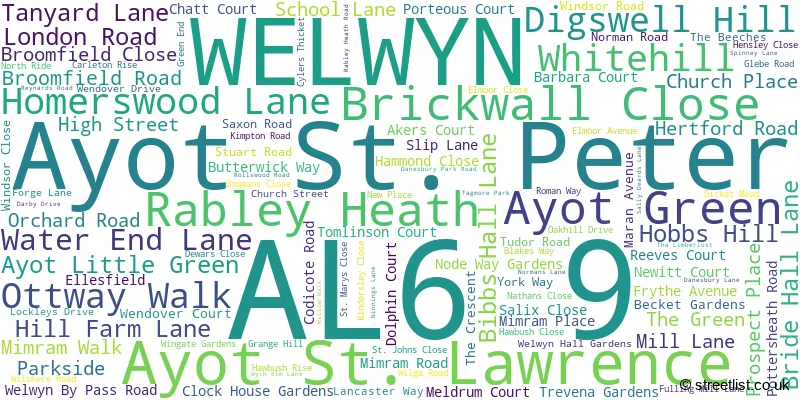
The largest settlement in the AL6 9 postal code is WELWYN followed by Ayot St. Peter, and Ayot St. Lawrence.
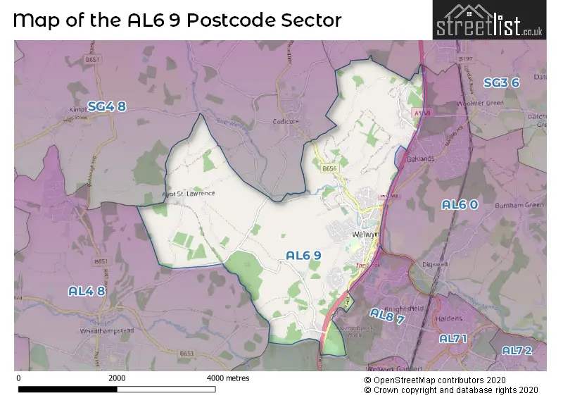
The AL6 9 Postcode shares a border with SG3 6 (KNEBWORTH, Woolmer Green, Datchworth), AL4 8 (Wheathampstead), AL6 0 (WELWYN, Tewin, Digswell), SG4 8 (Codicote, Kimpton, Whitwell) and AL8 7 (WELWYN GARDEN CITY, Lemsford).
The sector is within the post town of WELWYN.
AL6 9 is a postcode sector within the AL6 postcode district which is within the AL St Albans postcode area.
The Royal Mail delivery office for the AL6 9 postal sector is the Welwyn Garden City Delivery Office.
The area of the AL6 9 postcode sector is 6.29 square miles which is 16.30 square kilometres or 4,027.27 square acres.
The AL6 9 postcode sector is crossed by the A1M Major A road.

Map of the AL6 9 Postcode Sector
Explore the AL6 9 postcode sector by using our free interactive map.
| A | L | 6 | - | 9 | X | X |
| A | L | 6 | Space | 9 | Letter | Letter |
Official List of Streets
WELWYN (97 Streets)
Ayot St. Peter (4 Streets)
Ayot St. Lawrence (4 Streets)
Rabley Heath (3 Streets)
Unofficial Streets or Alternative Spellings
WELWYN
GREAT NORTH ROAD ROUNDWOOD CLOSE THE AVENUEDigswell
HERTFORD ROAD AYOT GREENWAY AYOT LITTLE GREEN LANE AYOT ST PETER ROAD CODICOTE HEIGHTS DANESBURY PARK DAWSON WAY FALLOW END GOSTWICK LODGE GREAT NORTH ROAD HALLS CLOSE HENWYK LODGE HOLLY HALL COURT LORD MEAD LANE OLD NURSERY WAY RECTORY ROAD RIVERSIDE THE CLOCK THE LIMBER LOST WELWYN BY-PASS ROAD WHITE HILLOld Knebworth
SLIP LANEWELWYN GARDEN CITY
BROCKSWOOD LANE GREAT NORTH ROADWheathampstead
CODICOTE ROAD WATEREND LANECodicote
HIGH STREET KIMPTON ROADWeather Forecast for AL6 9
Press Button to Show Forecast for Welwyn
| Time Period | Icon | Description | Temperature | Rain Probability | Wind |
|---|---|---|---|---|---|
| 15:00 to 18:00 | Heavy rain shower (day) | 10.0°C (feels like 7.0°C) | 83.00% | N 13 mph | |
| 18:00 to 21:00 | Cloudy | 8.0°C (feels like 6.0°C) | 10.00% | NNE 9 mph | |
| 21:00 to 00:00 | Clear night | 6.0°C (feels like 3.0°C) | 0.00% | N 9 mph |
Press Button to Show Forecast for Welwyn
| Time Period | Icon | Description | Temperature | Rain Probability | Wind |
|---|---|---|---|---|---|
| 00:00 to 03:00 | Clear night | 4.0°C (feels like 1.0°C) | 0.00% | NNW 9 mph | |
| 03:00 to 06:00 | Partly cloudy (night) | 3.0°C (feels like 0.0°C) | 1.00% | NNW 9 mph | |
| 06:00 to 09:00 | Cloudy | 4.0°C (feels like 0.0°C) | 3.00% | NNW 9 mph | |
| 09:00 to 12:00 | Cloudy | 7.0°C (feels like 4.0°C) | 7.00% | N 13 mph | |
| 12:00 to 15:00 | Cloudy | 9.0°C (feels like 7.0°C) | 7.00% | N 11 mph | |
| 15:00 to 18:00 | Overcast | 10.0°C (feels like 7.0°C) | 7.00% | N 11 mph | |
| 18:00 to 21:00 | Cloudy | 8.0°C (feels like 6.0°C) | 4.00% | NNE 9 mph | |
| 21:00 to 00:00 | Cloudy | 6.0°C (feels like 4.0°C) | 4.00% | NNE 4 mph |
Press Button to Show Forecast for Welwyn
| Time Period | Icon | Description | Temperature | Rain Probability | Wind |
|---|---|---|---|---|---|
| 00:00 to 03:00 | Partly cloudy (night) | 5.0°C (feels like 3.0°C) | 1.00% | N 4 mph | |
| 03:00 to 06:00 | Partly cloudy (night) | 4.0°C (feels like 1.0°C) | 2.00% | NNW 7 mph | |
| 06:00 to 09:00 | Cloudy | 4.0°C (feels like 2.0°C) | 6.00% | N 7 mph | |
| 09:00 to 12:00 | Overcast | 7.0°C (feels like 4.0°C) | 10.00% | NNE 11 mph | |
| 12:00 to 15:00 | Overcast | 9.0°C (feels like 6.0°C) | 9.00% | NNE 11 mph | |
| 15:00 to 18:00 | Overcast | 10.0°C (feels like 7.0°C) | 9.00% | NNE 11 mph | |
| 18:00 to 21:00 | Partly cloudy (day) | 8.0°C (feels like 6.0°C) | 3.00% | NNE 11 mph | |
| 21:00 to 00:00 | Partly cloudy (night) | 6.0°C (feels like 3.0°C) | 2.00% | NNE 9 mph |
Press Button to Show Forecast for Welwyn
| Time Period | Icon | Description | Temperature | Rain Probability | Wind |
|---|---|---|---|---|---|
| 00:00 to 03:00 | Partly cloudy (night) | 4.0°C (feels like 2.0°C) | 2.00% | NNE 7 mph | |
| 03:00 to 06:00 | Partly cloudy (night) | 3.0°C (feels like 1.0°C) | 3.00% | N 7 mph | |
| 06:00 to 09:00 | Cloudy | 4.0°C (feels like 1.0°C) | 7.00% | N 7 mph | |
| 09:00 to 12:00 | Cloudy | 7.0°C (feels like 6.0°C) | 9.00% | N 7 mph | |
| 12:00 to 15:00 | Cloudy | 9.0°C (feels like 7.0°C) | 13.00% | N 7 mph | |
| 15:00 to 18:00 | Overcast | 9.0°C (feels like 7.0°C) | 18.00% | NNW 7 mph | |
| 18:00 to 21:00 | Cloudy | 8.0°C (feels like 6.0°C) | 13.00% | N 7 mph | |
| 21:00 to 00:00 | Cloudy | 6.0°C (feels like 4.0°C) | 13.00% | N 4 mph |
Press Button to Show Forecast for Welwyn
| Time Period | Icon | Description | Temperature | Rain Probability | Wind |
|---|---|---|---|---|---|
| 00:00 to 03:00 | Light rain shower (night) | 5.0°C (feels like 4.0°C) | 31.00% | NNW 4 mph | |
| 03:00 to 06:00 | Light rain shower (night) | 5.0°C (feels like 3.0°C) | 30.00% | N 4 mph | |
| 06:00 to 09:00 | Cloudy | 5.0°C (feels like 3.0°C) | 10.00% | N 7 mph | |
| 09:00 to 12:00 | Overcast | 8.0°C (feels like 6.0°C) | 12.00% | N 9 mph | |
| 12:00 to 15:00 | Overcast | 10.0°C (feels like 8.0°C) | 15.00% | N 9 mph | |
| 15:00 to 18:00 | Overcast | 10.0°C (feels like 8.0°C) | 21.00% | NNE 9 mph | |
| 18:00 to 21:00 | Partly cloudy (day) | 10.0°C (feels like 7.0°C) | 3.00% | NNE 9 mph | |
| 21:00 to 00:00 | Clear night | 6.0°C (feels like 4.0°C) | 2.00% | NNE 7 mph |
Schools and Places of Education Within the AL6 9 Postcode Sector
Tenterfield Nursery School
Local authority nursery school
London Road, Welwyn, Hertfordshire, AL6 9JF
Head: Mrs Victoria Beare
Ofsted Rating: Outstanding
Inspection: 2023-03-23 (393 days ago)
Website: Visit Tenterfield Nursery School Website
Phone: 01438714564
Number of Pupils: 66
Welwyn St Mary's Church of England Voluntary Aided Primary School
Voluntary aided school
15 London Road, Welwyn, Hertfordshire, AL6 9DJ
Head: Mr Stuart Whiteland
Ofsted Rating: Outstanding
Inspection: 2013-09-25 (3859 days ago)
Website: Visit Welwyn St Mary's Church of England Voluntary Aided Primary School Website
Phone: 01438714169
Number of Pupils: 421
House Prices in the AL6 9 Postcode Sector
| Type of Property | 2018 Average | 2018 Sales | 2017 Average | 2017 Sales | 2016 Average | 2016 Sales | 2015 Average | 2015 Sales |
|---|---|---|---|---|---|---|---|---|
| Detached | £830,826 | 34 | £845,773 | 46 | £870,817 | 60 | £858,610 | 41 |
| Semi-Detached | £563,673 | 21 | £640,382 | 39 | £553,367 | 30 | £476,555 | 18 |
| Terraced | £475,438 | 20 | £445,873 | 24 | £519,124 | 20 | £476,848 | 23 |
| Flats | £350,107 | 14 | £235,606 | 14 | £265,559 | 17 | £214,761 | 49 |
Important Postcodes AL6 9 in the Postcode Sector
AL6 9DJ is the postcode for Welwyn St. Marys Primary School, 15 London Road
AL6 9EF is the postcode for Bridge Cottage Surgery, 41 High Street
AL6 9ER is the postcode for Welwyn Civic Centre, Prospect Place
AL6 9PW is the postcode for QUEEN VICTORIA MEMORIAL HOSPITAL, 73 SCHOOL LANE, WELWYN, Queen Victoria Memorial Hospital, School Lane, East and North Hertfordshire PCT, Danesbury Hospital, and East and North Hertfordshire PCT, Queen Victoria Memorial Hospital (welwyn)
AL6 9SB is the postcode for DANESBURY HOME, 73 SCHOOL LANE, WELWYN, Danesbury Neurological Centre, School Lane, and Danesbury Home, School Lane
| The AL6 9 Sector is within these Local Authorities |
|
|---|---|
| The AL6 9 Sector is within these Counties |
|
| The AL6 9 Sector is within these Water Company Areas |
|
Tourist Attractions within the AL6 9 Postcode Area
We found 2 visitor attractions within the AL6 postcode area
| Shaw's Corner |
|---|
| Historic Properties |
| Historic House / House and Garden / Palace |
| View Shaw's Corner on Google Maps |
| Welwyn Roman Baths |
| Historic Properties |
| Historic Monument / Archaeological Site |
| View Welwyn Roman Baths on Google Maps |