The B11 4 postcode sector is within the county of West Midlands.
Did you know? According to the 2021 Census, the B11 4 postcode sector is home to a bustling 12,508 residents!
Given that each sector allows for 400 unique postcode combinations. Letters C, I, K, M, O and V are not allowed in the last two letters of a postcode. With 142 postcodes already in use, this leaves 258 units available.
The largest settlements in the B11 4 postal code are Sparkhill and BIRMINGHAM.
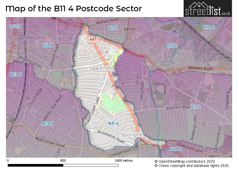
The B11 4 Postcode shares a border with B11 1 (BIRMINGHAM, Sparkhill, Sparkbrook), B12 8 (BIRMINGHAM, Balsall Heath, Sparkbrook), B11 2 (BIRMINGHAM, Tyseley, Sparkbrook), B11 3 (BIRMINGHAM, Sparkhill, Tyseley), B13 9 (BIRMINGHAM, Moseley, Kings Heath) and B28 8 (BIRMINGHAM, Hall Green).
The sector is within the post town of BIRMINGHAM.
B11 4 is a postcode sector within the B11 postcode district which is within the B Birmingham postcode area.
The Royal Mail delivery office for the B11 4 postal sector is the Camp Hill Delivery Office.
The area of the B11 4 postcode sector is 0.44 square miles which is 1.15 square kilometres or 283.36 square acres.
Waterways within the B11 4 postcode sector include the River Cole.

Map of the B11 4 Postcode Sector
Explore the B11 4 postcode sector by using our free interactive map.
| B | 1 | 1 | - | 4 | X | X |
| B | 1 | 1 | Space | 4 | Letter | Letter |
Official List of Streets
BIRMINGHAM (28 Streets)
Sparkhill (20 Streets)
Unofficial Streets or Alternative Spellings
BIRMINGHAM
ANDERTON PARK ROAD AVONDALE ROAD BLACKFORD ROAD BROMYARD ROAD CASTLEFORD ROAD EVELYN ROAD FERNLEY ROAD HILLFIELD ROAD KNOWLE ROAD MEDLICOTT ROAD OSBORN ROAD SAREHOLE ROAD TENBY ROAD WALFORD ROADAcocks Green
SHAFTMOOR LANE WARWICK ROADHall Green
STRATFORD ROADSparkhill
CLARENCE ROAD FORMANS ROAD POPLAR ROAD SOLIHULL ROAD THORNHILL ROADShirley
YARDLEY WOOD ROAD GEOFFREY PLACE LIME COURT LYONS CLOSE TRENVILLE AVENUESparkbrook
HIGHGATE ROADMoseley
COLLEGE ROAD SPRINGFIELD ROADBalsall Heath
STONEY LANEWeather Forecast for B11 4
Press Button to Show Forecast for Ackers Trust Ski Centre
| Time Period | Icon | Description | Temperature | Rain Probability | Wind |
|---|---|---|---|---|---|
| 09:00 to 12:00 | Cloudy | 7.0°C (feels like 5.0°C) | 10.00% | WNW 9 mph | |
| 12:00 to 15:00 | Overcast | 9.0°C (feels like 7.0°C) | 10.00% | NW 11 mph | |
| 15:00 to 18:00 | Cloudy | 9.0°C (feels like 7.0°C) | 11.00% | N 9 mph | |
| 18:00 to 21:00 | Cloudy | 9.0°C (feels like 8.0°C) | 9.00% | NNE 4 mph | |
| 21:00 to 00:00 | Cloudy | 8.0°C (feels like 6.0°C) | 4.00% | ENE 4 mph |
Press Button to Show Forecast for Ackers Trust Ski Centre
| Time Period | Icon | Description | Temperature | Rain Probability | Wind |
|---|---|---|---|---|---|
| 00:00 to 03:00 | Cloudy | 6.0°C (feels like 4.0°C) | 10.00% | E 7 mph | |
| 03:00 to 06:00 | Cloudy | 5.0°C (feels like 3.0°C) | 7.00% | E 4 mph | |
| 06:00 to 09:00 | Cloudy | 4.0°C (feels like 2.0°C) | 5.00% | ENE 4 mph | |
| 09:00 to 12:00 | Cloudy | 6.0°C (feels like 4.0°C) | 6.00% | ENE 7 mph | |
| 12:00 to 15:00 | Overcast | 9.0°C (feels like 7.0°C) | 11.00% | ENE 7 mph | |
| 15:00 to 18:00 | Overcast | 10.0°C (feels like 8.0°C) | 12.00% | E 7 mph | |
| 18:00 to 21:00 | Cloudy | 9.0°C (feels like 8.0°C) | 10.00% | ENE 7 mph | |
| 21:00 to 00:00 | Partly cloudy (night) | 7.0°C (feels like 5.0°C) | 9.00% | E 7 mph |
Press Button to Show Forecast for Ackers Trust Ski Centre
| Time Period | Icon | Description | Temperature | Rain Probability | Wind |
|---|---|---|---|---|---|
| 00:00 to 03:00 | Cloudy | 5.0°C (feels like 3.0°C) | 12.00% | ENE 7 mph | |
| 03:00 to 06:00 | Cloudy | 4.0°C (feels like 2.0°C) | 13.00% | ENE 7 mph | |
| 06:00 to 09:00 | Cloudy | 5.0°C (feels like 2.0°C) | 14.00% | ENE 7 mph | |
| 09:00 to 12:00 | Cloudy | 7.0°C (feels like 4.0°C) | 19.00% | ENE 9 mph | |
| 12:00 to 15:00 | Light rain | 9.0°C (feels like 6.0°C) | 53.00% | ENE 9 mph | |
| 15:00 to 18:00 | Overcast | 10.0°C (feels like 8.0°C) | 23.00% | ENE 9 mph | |
| 18:00 to 21:00 | Cloudy | 10.0°C (feels like 7.0°C) | 19.00% | ENE 9 mph | |
| 21:00 to 00:00 | Cloudy | 8.0°C (feels like 6.0°C) | 22.00% | NE 9 mph |
Press Button to Show Forecast for Ackers Trust Ski Centre
| Time Period | Icon | Description | Temperature | Rain Probability | Wind |
|---|---|---|---|---|---|
| 00:00 to 03:00 | Light rain | 7.0°C (feels like 4.0°C) | 52.00% | NE 9 mph | |
| 03:00 to 06:00 | Heavy rain | 7.0°C (feels like 4.0°C) | 70.00% | NE 9 mph | |
| 06:00 to 09:00 | Heavy rain | 7.0°C (feels like 4.0°C) | 73.00% | NNE 9 mph | |
| 09:00 to 12:00 | Heavy rain | 8.0°C (feels like 6.0°C) | 75.00% | NNE 9 mph | |
| 12:00 to 15:00 | Light rain shower (day) | 10.0°C (feels like 8.0°C) | 43.00% | NNE 9 mph | |
| 15:00 to 18:00 | Heavy rain shower (day) | 11.0°C (feels like 9.0°C) | 59.00% | NW 9 mph | |
| 18:00 to 21:00 | Heavy rain shower (day) | 11.0°C (feels like 9.0°C) | 53.00% | NNW 9 mph | |
| 21:00 to 00:00 | Clear night | 9.0°C (feels like 7.0°C) | 11.00% | WNW 7 mph |
Schools and Places of Education Within the B11 4 Postcode Sector
Arden Primary School
Community school
Baker Street, Birmingham, West Midlands, B11 4SF
Head: Mrs Gurjit Shergill
Ofsted Rating: Good
Inspection: 2019-02-27 (1884 days ago)
Website: Visit Arden Primary School Website
Phone: 01216757702
Number of Pupils: 703
City of Birmingham School
Pupil referral unit
14 Court Road, Birmingham, , B11 4LX
Head: Mr Steve Howell
Ofsted Rating: Requires improvement
Inspection: 2022-03-10 (777 days ago)
Website: Visit City of Birmingham School Website
Phone: 01213030272
Number of Pupils: 351
St John's CofE Primary School
Academy converter
Stratford Road, Birmingham, West Midlands, B11 4EA
Head: Mrs Naomi Hedges
Ofsted Rating: Outstanding
Inspection: 2014-11-20 (3444 days ago)
Website: Visit St John's CofE Primary School Website
Phone: 01216751469
Number of Pupils: 471
House Prices in the B11 4 Postcode Sector
| Type of Property | 2018 Average | 2018 Sales | 2017 Average | 2017 Sales | 2016 Average | 2016 Sales | 2015 Average | 2015 Sales |
|---|---|---|---|---|---|---|---|---|
| Detached | £251,333 | 3 | £274,437 | 5 | £245,000 | 2 | £380,000 | 1 |
| Semi-Detached | £220,482 | 12 | £186,964 | 14 | £211,500 | 6 | £220,750 | 8 |
| Terraced | £155,743 | 53 | £147,518 | 49 | £152,292 | 53 | £137,667 | 39 |
| Flats | £75,000 | 1 | £102,500 | 1 | £240,000 | 1 | £0 | 0 |
Important Postcodes B11 4 in the Postcode Sector
B11 4AN is the postcode for South Birmingham Mental Health NHS Trust, Stratford Road Day Centre, 572 Stratford Road, STRATFORD HOUSE SURGERY, Sparkhill Surgery, 578 Stratford Road, and Fernley Medical Centre, 560 Stratford Road
B11 4AR is the postcode for 636a Stratford Road, Springfield
B11 4BW is the postcode for Sparkhill Primary Care Centre, 856 Stratford Road, and SPARKHILL PRIMARY CARE CENTRE, 856 STRATFORD ROAD, SPRINGFIELD
B11 4DY is the postcode for Sparkhill Pool & Fitness Centre, Stratford Road, Sparkhill, Sparkhill Pool & Fitness Centre, Stratford Road, and Birmingham City Council, 641 Stratford Road
B11 4EA is the postcode for St. Johns C of E Junior & Infant School, Stratford Road, Sparkhill, St Johns Church Of England School, Stratford Road, Springfield, and St. Johns C of E Junior & Infant School, Stratford Road
B11 4HB is the postcode for Park House Child & Family Centre, Park Road
B11 4HL is the postcode for Birmingham & Solihull Mental Health NHS Trust, 100 Showell Green Lane
B11 4LE is the postcode for SPARKHILL ADULT EDUCATION CENTRE, STRATFORD ROAD, and Sparkhill Adult Education Centre, 477 Stratford Road
B11 4SF is the postcode for Arden Primary School, Baker Street, Sparkhill, and Arden Primary School, Baker Street
| The B11 4 Sector is within these Local Authorities |
|
|---|---|
| The B11 4 Sector is within these Counties |
|
| The B11 4 Sector is within these Water Company Areas |
|