The B20 1 postcode sector is within the county of West Midlands.
Did you know? According to the 2021 Census, the B20 1 postcode sector is home to a bustling 8,640 residents!
Given that each sector allows for 400 unique postcode combinations. Letters C, I, K, M, O and V are not allowed in the last two letters of a postcode. With 128 postcodes already in use, this leaves 272 units available.
The B20 1 postal code covers the settlement of BIRMINGHAM.
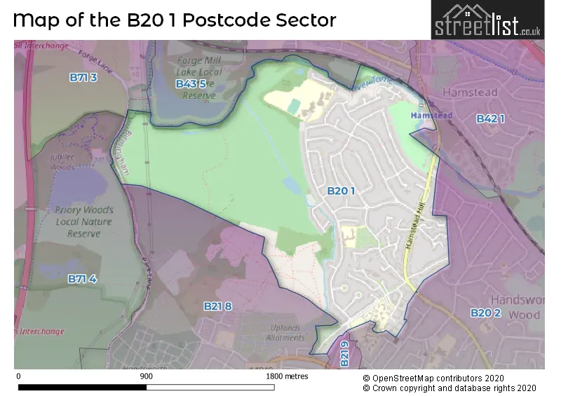
The B20 1 Postcode shares a border with B43 5 (BIRMINGHAM, Great Barr), B71 3 (WEST BROMWICH), B20 2 (BIRMINGHAM, Handsworth), B21 8 (BIRMINGHAM, Handsworth), B21 9 (Handsworth, BIRMINGHAM), B42 1 (BIRMINGHAM, Perry Barr, Great Barr) and B71 4 (WEST BROMWICH, Sandwell).
The sector is within the post town of BIRMINGHAM.
B20 1 is a postcode sector within the B20 postcode district which is within the B Birmingham postcode area.
The Royal Mail delivery office for the B20 1 postal sector is the Handsworth Delivery Office.
The area of the B20 1 postcode sector is 1.04 square miles which is 2.70 square kilometres or 668.09 square acres.
Waterways within the B20 1 postcode sector include the River Tame.

Map of the B20 1 Postcode Sector
Explore the B20 1 postcode sector by using our free interactive map.
| B | 2 | 0 | - | 1 | X | X |
| B | 2 | 0 | Space | 1 | Letter | Letter |
Official List of Streets
BIRMINGHAM (53 Streets)
Unofficial Streets or Alternative Spellings
BIRMINGHAM
CHERRY ORCHARD ROAD STOCKWELL ROAD BEECHWOOD HAWTHORN PARK DRIVE LAKESIDE COURT TAME VALLEY WAY WILTSHIRE AVENUEHandsworth
COLLEGE ROAD HANDSWORTH WOOD ROAD WEST AVENUEHamstead Industrial Estate
OLD WALSALL ROADWeather Forecast for B20 1
Press Button to Show Forecast for Brown's Green
| Time Period | Icon | Description | Temperature | Rain Probability | Wind |
|---|---|---|---|---|---|
| 21:00 to 00:00 | Cloudy | 8.0°C (feels like 7.0°C) | 8.00% | NNE 4 mph |
Press Button to Show Forecast for Brown's Green
| Time Period | Icon | Description | Temperature | Rain Probability | Wind |
|---|---|---|---|---|---|
| 00:00 to 03:00 | Cloudy | 6.0°C (feels like 5.0°C) | 5.00% | N 4 mph | |
| 03:00 to 06:00 | Cloudy | 6.0°C (feels like 5.0°C) | 9.00% | NNW 2 mph | |
| 06:00 to 09:00 | Cloudy | 6.0°C (feels like 4.0°C) | 5.00% | NNE 7 mph | |
| 09:00 to 12:00 | Cloudy | 7.0°C (feels like 5.0°C) | 3.00% | N 7 mph | |
| 12:00 to 15:00 | Cloudy | 10.0°C (feels like 8.0°C) | 3.00% | N 7 mph | |
| 15:00 to 18:00 | Sunny day | 11.0°C (feels like 10.0°C) | 1.00% | NNW 7 mph | |
| 18:00 to 21:00 | Sunny day | 10.0°C (feels like 9.0°C) | 1.00% | NNW 7 mph | |
| 21:00 to 00:00 | Clear night | 7.0°C (feels like 5.0°C) | 1.00% | NNW 7 mph |
Press Button to Show Forecast for Brown's Green
| Time Period | Icon | Description | Temperature | Rain Probability | Wind |
|---|---|---|---|---|---|
| 00:00 to 03:00 | Cloudy | 5.0°C (feels like 3.0°C) | 4.00% | NW 4 mph | |
| 03:00 to 06:00 | Cloudy | 4.0°C (feels like 1.0°C) | 4.00% | W 7 mph | |
| 06:00 to 09:00 | Cloudy | 5.0°C (feels like 2.0°C) | 5.00% | W 7 mph | |
| 09:00 to 12:00 | Overcast | 7.0°C (feels like 4.0°C) | 12.00% | WNW 9 mph | |
| 12:00 to 15:00 | Cloudy | 9.0°C (feels like 7.0°C) | 11.00% | NW 9 mph | |
| 15:00 to 18:00 | Cloudy | 10.0°C (feels like 8.0°C) | 9.00% | NNW 9 mph | |
| 18:00 to 21:00 | Cloudy | 9.0°C (feels like 7.0°C) | 5.00% | NNW 7 mph | |
| 21:00 to 00:00 | Cloudy | 6.0°C (feels like 5.0°C) | 5.00% | NNE 4 mph |
Press Button to Show Forecast for Brown's Green
| Time Period | Icon | Description | Temperature | Rain Probability | Wind |
|---|---|---|---|---|---|
| 00:00 to 03:00 | Cloudy | 5.0°C (feels like 3.0°C) | 6.00% | ENE 4 mph | |
| 03:00 to 06:00 | Cloudy | 4.0°C (feels like 2.0°C) | 9.00% | ENE 4 mph | |
| 06:00 to 09:00 | Cloudy | 4.0°C (feels like 2.0°C) | 12.00% | E 7 mph | |
| 09:00 to 12:00 | Cloudy | 6.0°C (feels like 4.0°C) | 15.00% | ESE 7 mph | |
| 12:00 to 15:00 | Overcast | 9.0°C (feels like 7.0°C) | 19.00% | ESE 7 mph | |
| 15:00 to 18:00 | Overcast | 9.0°C (feels like 7.0°C) | 19.00% | E 7 mph | |
| 18:00 to 21:00 | Cloudy | 8.0°C (feels like 6.0°C) | 21.00% | E 9 mph | |
| 21:00 to 00:00 | Cloudy | 7.0°C (feels like 4.0°C) | 25.00% | E 7 mph |
Press Button to Show Forecast for Brown's Green
| Time Period | Icon | Description | Temperature | Rain Probability | Wind |
|---|---|---|---|---|---|
| 00:00 to 03:00 | Cloudy | 6.0°C (feels like 3.0°C) | 23.00% | E 7 mph | |
| 03:00 to 06:00 | Cloudy | 5.0°C (feels like 3.0°C) | 24.00% | E 7 mph | |
| 06:00 to 09:00 | Overcast | 5.0°C (feels like 3.0°C) | 25.00% | E 7 mph | |
| 09:00 to 12:00 | Overcast | 7.0°C (feels like 5.0°C) | 20.00% | ENE 9 mph | |
| 12:00 to 15:00 | Cloudy | 10.0°C (feels like 7.0°C) | 22.00% | E 9 mph | |
| 15:00 to 18:00 | Cloudy | 10.0°C (feels like 8.0°C) | 22.00% | E 9 mph | |
| 18:00 to 21:00 | Light rain | 10.0°C (feels like 8.0°C) | 51.00% | ENE 9 mph | |
| 21:00 to 00:00 | Light rain | 8.0°C (feels like 6.0°C) | 50.00% | NE 9 mph |
Schools and Places of Education Within the B20 1 Postcode Sector
Grestone Academy
Academy sponsor led
Grestone Avenue, Birmingham, West Midlands, B20 1ND
Head: Mrs Deborah Steen
Ofsted Rating: Good
Inspection: 2023-12-14 (131 days ago)
Website: Visit Grestone Academy Website
Phone: 01216756787
Number of Pupils: 419
Hamstead Hall Academy
Academy converter
Craythorne Avenue, Birmingham, West Midlands, B20 1HL
Head: Mrs Carla Tranter
Ofsted Rating: Good
Inspection: 2019-01-22 (1918 days ago)
Website: Visit Hamstead Hall Academy Website
Phone: 01213867510
Number of Pupils: 1140
House Prices in the B20 1 Postcode Sector
| Type of Property | 2018 Average | 2018 Sales | 2017 Average | 2017 Sales | 2016 Average | 2016 Sales | 2015 Average | 2015 Sales |
|---|---|---|---|---|---|---|---|---|
| Detached | £328,875 | 16 | £235,711 | 19 | £266,630 | 23 | £269,838 | 25 |
| Semi-Detached | £198,990 | 24 | £224,667 | 24 | £185,144 | 31 | £155,831 | 27 |
| Terraced | £196,593 | 14 | £189,720 | 15 | £164,150 | 13 | £165,023 | 11 |
| Flats | £110,375 | 2 | £97,500 | 2 | £0 | 0 | £65,000 | 1 |
Important Postcodes B20 1 in the Postcode Sector
B20 1AP is the postcode for Birmingham City University, Aspen Building, Birmingham City University, Hamstead Hall, and Birmingham City University, Rowan Building
B20 1HL is the postcode for Hamstead Hall Academy, Craythorne Avenue, WOOD END BUILDING, Hamstead Hall Academy, Craythorne Avenue, MOILLIET BUILDING, Hamstead Hall Academy, Craythorne Avenue, CRAYTHORNE BUILDING, Hamstead Hall Academy, Craythorne Avenue, SPORTS HALL, Hamstead Hall Academy, Craythorne Avenue, PARKSIDE BUILDING, Hamstead Hall Academy, Craythorne Avenue, and ASPIRATION BUILDING, Hamstead Hall Academy, Craythorne Avenue
B20 1ND is the postcode for Grestone Academy, Grestone Avenue
| The B20 1 Sector is within these Local Authorities |
|
|---|---|
| The B20 1 Sector is within these Counties |
|
| The B20 1 Sector is within these Water Company Areas |
|