The B23 postcode district is a postal district located in the B Birmingham postcode area with a population of 48,328 residents according to the 2021 England and Wales Census.
The area of the B23 postcode district is 3.17 square miles which is 8.22 square kilometres or 2,031.75 acres.
Currently, the B23 district has about 822 postcode units spread across 3 geographic postcode sectors.
Given that each sector allows for 400 unique postcode combinations, the district has a capacity of 1,200 postcodes. With 822 postcodes already in use, this leaves 378 units available.
The largest settlements in the B23 postal code are BIRMINGHAM and Erdington.
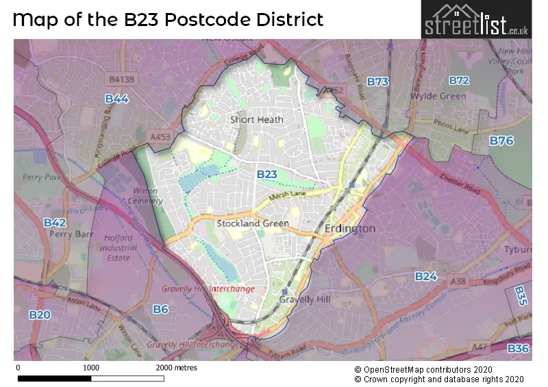
The B23 Postcode shares a border with B73 (SUTTON COLDFIELD, Wylde Green), B44 (BIRMINGHAM, Great Barr, Kingstanding) and B24 (BIRMINGHAM, Erdington).
In the B23 postcode district of Birmingham, the primary settlement with the highest count is Erdington. Other significant settlements include Stockland Green. The post town for this district is Birmingham, located in the West Midlands county of England.
For the district B23, we have data on 4 postcode sectors. Here's a breakdown: The sector B23 3 is non-geographic. It's often designated for PO Boxes, large organisations, or special services. The sector B23 5, covers Birmingham in West Midlands. The sector B23 6, covers Birmingham and Erdington in West Midlands. The sector B23 7, covers Birmingham and Erdington in West Midlands.

Map of the B23 Postcode District
Explore the B23 postcode district by using our free interactive map.
When it comes to local government, postal geography often disregards political borders. However, for a breakdown in the B23 District: the district mostly encompasses the Birmingham District (B) area with a total of 829 postcodes.
Weather Forecast for B23
Press Button to Show Forecast for Short Heath
| Time Period | Icon | Description | Temperature | Rain Probability | Wind |
|---|---|---|---|---|---|
| 21:00 to 00:00 | Cloudy | 7.0°C (feels like 5.0°C) | 6.00% | ENE 7 mph |
Press Button to Show Forecast for Short Heath
| Time Period | Icon | Description | Temperature | Rain Probability | Wind |
|---|---|---|---|---|---|
| 00:00 to 03:00 | Cloudy | 5.0°C (feels like 3.0°C) | 8.00% | E 7 mph | |
| 03:00 to 06:00 | Cloudy | 4.0°C (feels like 2.0°C) | 6.00% | E 4 mph | |
| 06:00 to 09:00 | Partly cloudy (day) | 4.0°C (feels like 2.0°C) | 2.00% | ENE 4 mph | |
| 09:00 to 12:00 | Cloudy | 6.0°C (feels like 4.0°C) | 5.00% | ENE 7 mph | |
| 12:00 to 15:00 | Overcast | 9.0°C (feels like 7.0°C) | 10.00% | ENE 7 mph | |
| 15:00 to 18:00 | Overcast | 9.0°C (feels like 8.0°C) | 11.00% | ENE 7 mph | |
| 18:00 to 21:00 | Cloudy | 9.0°C (feels like 7.0°C) | 9.00% | ENE 7 mph | |
| 21:00 to 00:00 | Partly cloudy (night) | 7.0°C (feels like 4.0°C) | 8.00% | E 7 mph |
Press Button to Show Forecast for Short Heath
| Time Period | Icon | Description | Temperature | Rain Probability | Wind |
|---|---|---|---|---|---|
| 00:00 to 03:00 | Cloudy | 5.0°C (feels like 3.0°C) | 12.00% | ENE 7 mph | |
| 03:00 to 06:00 | Cloudy | 4.0°C (feels like 2.0°C) | 12.00% | ENE 7 mph | |
| 06:00 to 09:00 | Cloudy | 4.0°C (feels like 2.0°C) | 13.00% | ENE 7 mph | |
| 09:00 to 12:00 | Cloudy | 7.0°C (feels like 4.0°C) | 17.00% | ENE 9 mph | |
| 12:00 to 15:00 | Overcast | 9.0°C (feels like 6.0°C) | 25.00% | ENE 9 mph | |
| 15:00 to 18:00 | Light rain | 10.0°C (feels like 8.0°C) | 49.00% | ENE 9 mph | |
| 18:00 to 21:00 | Cloudy | 9.0°C (feels like 7.0°C) | 19.00% | ENE 9 mph | |
| 21:00 to 00:00 | Cloudy | 8.0°C (feels like 5.0°C) | 21.00% | NE 9 mph |
Press Button to Show Forecast for Short Heath
| Time Period | Icon | Description | Temperature | Rain Probability | Wind |
|---|---|---|---|---|---|
| 00:00 to 03:00 | Light rain | 7.0°C (feels like 4.0°C) | 51.00% | NE 9 mph | |
| 03:00 to 06:00 | Light rain | 7.0°C (feels like 4.0°C) | 52.00% | NE 9 mph | |
| 06:00 to 09:00 | Heavy rain | 7.0°C (feels like 4.0°C) | 75.00% | NNE 9 mph | |
| 09:00 to 12:00 | Heavy rain | 8.0°C (feels like 6.0°C) | 76.00% | NNE 9 mph | |
| 12:00 to 15:00 | Light rain | 10.0°C (feels like 8.0°C) | 53.00% | NNW 9 mph | |
| 15:00 to 18:00 | Light rain | 11.0°C (feels like 9.0°C) | 54.00% | N 9 mph | |
| 18:00 to 21:00 | Heavy rain shower (day) | 10.0°C (feels like 9.0°C) | 56.00% | WSW 9 mph | |
| 21:00 to 00:00 | Partly cloudy (night) | 9.0°C (feels like 7.0°C) | 11.00% | SW 7 mph |
Where is the B23 Postcode District?
The postcode district B23 is located in Birmingham. It is near towns such as Sutton Coldfield, Smethwick, West Bromwich, Solihull, and Walsall. Additionally, B23 is approximately 102.06 miles away from the center of London.
The district is within the post town of BIRMINGHAM.
The sector has postcodes within the nation of England.
The B23 Postcode District is in the Birmingham region of West Midlands within the West Midlands (England).
| Postcode Sector | Delivery Office |
|---|---|
| B23 5 | Erdington Delivery Office |
| B23 6 | Erdington Delivery Office |
| B23 7 | Erdington Delivery Office |
| B | 2 | 3 | - | X | X | X |
| B | 2 | 3 | Space | Numeric | Letter | Letter |
Current Monthly Rental Prices
| # Bedrooms | Min Price | Max Price | Avg Price |
|---|---|---|---|
| 1 | £750 | £750 | £750 |
| 2 | £750 | £1,150 | £921 |
| 3 | £1,000 | £1,600 | £1,261 |
| 4 | £1,150 | £1,600 | £1,300 |
| 6 | £2,500 | £2,500 | £2,500 |
Current House Prices
| # Bedrooms | Min Price | Max Price | Avg Price |
|---|---|---|---|
| £1,399,000 | £1,399,000 | £1,399,000 | |
| 3 | £300,000 | £450,000 | £342,450 |
| 4 | £300,000 | £415,000 | £354,279 |
| 5 | £310,000 | £425,000 | £365,833 |
| 6 | £324,000 | £369,950 | £346,975 |
Estate Agents who Operate in the B23 District
| Logo | Name | Brand Name | Address | Contact Number | Total Properties |
|---|---|---|---|---|---|
 | Erdington | Paul Carr | 19 York Road, Erdington, Birmingham, B23 6TE | 0121 387 6412 | 43 |
 | Covering West Midlands | Homewise | B46 1DL | 01273 092409 | 32 |
 | Erdington | Dixons | 1 Sutton New Road, Erdington, Birmingham, W Midlands, B23 6TJ | 0121 387 6273 | 24 |
 | Birmingham | Waller & Farnworth | 2 York Road, Erdington, Birmingham, B23 6TE | 0121 387 6585 | 22 |
 | Erdington | Burchell Edwards | Unit 3 Queens Court Gravelly Hill North Stockland Green Birmingham B23 6BJ | 0121 387 6363 | 19 |
| Type of Property | 2018 Average | 2018 Sales | 2017 Average | 2017 Sales | 2016 Average | 2016 Sales | 2015 Average | 2015 Sales |
|---|---|---|---|---|---|---|---|---|
| Detached | £222,283 | 46 | £238,071 | 35 | £223,407 | 33 | £194,432 | 31 |
| Semi-Detached | £175,412 | 259 | £165,275 | 215 | £148,053 | 203 | £144,153 | 225 |
| Terraced | £146,232 | 268 | £138,897 | 315 | £124,527 | 298 | £118,299 | 281 |
| Flats | £100,704 | 128 | £93,683 | 113 | £86,983 | 147 | £77,409 | 123 |