The B26 postcode district is a postal district located in the B Birmingham postcode area with a population of 34,601 residents according to the 2021 England and Wales Census.
The area of the B26 postcode district is 3.58 square miles which is 9.26 square kilometres or 2,288.68 acres.
Currently, the B26 district has about 570 postcode units spread across 3 geographic postcode sectors.
Given that each sector allows for 400 unique postcode combinations, the district has a capacity of 1,200 postcodes. With 570 postcodes already in use, this leaves 630 units available.
The largest settlement in the B26 postal code is BIRMINGHAM followed by Sheldon, and Yardley.
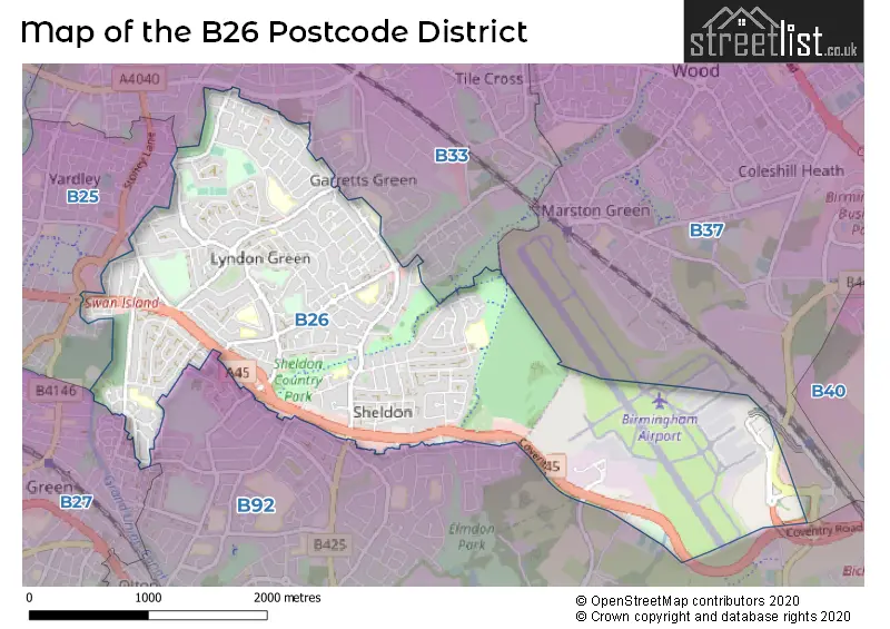
The B26 Postcode shares a border with B92 (SOLIHULL, Hampton-in-Arden, Barston), B33 (BIRMINGHAM, Stechford, Kitts Green), B25 (BIRMINGHAM, Yardley) and B27 (BIRMINGHAM, Acocks Green).
The primary settlement in the B26 postcode district is Birmingham, located in the county of West Midlands in England. Other significant settlements in this district include Sheldon and Yardley, also within the county of West Midlands. The most significant post town in the B26 postcode district is Birmingham.
For the district B26, we have data on 3 postcode sectors. Here's a breakdown: The sector B26 1, covers Birmingham and Yardley in West Midlands. The sector B26 2, covers Birmingham in West Midlands. The sector B26 3, covers Birmingham and Sheldon in West Midlands.


Map of the B26 Postcode District
Explore the B26 postcode district by using our free interactive map.
When it comes to local government, postal geography often disregards political borders. However, for a breakdown in the B26 District: the district mostly encompasses the Birmingham District (B) (553 postcodes), and finally, the Solihull District (B) area (19 postcodes).
Weather Forecast for B26
Press Button to Show Forecast for Lyndon Green
| Time Period | Icon | Description | Temperature | Rain Probability | Wind |
|---|---|---|---|---|---|
| 09:00 to 12:00 | Partly cloudy (day) | 7.0°C (feels like 5.0°C) | 1.00% | N 7 mph | |
| 12:00 to 15:00 | Cloudy | 10.0°C (feels like 8.0°C) | 3.00% | N 7 mph | |
| 15:00 to 18:00 | Partly cloudy (day) | 11.0°C (feels like 10.0°C) | 1.00% | N 7 mph | |
| 18:00 to 21:00 | Partly cloudy (day) | 11.0°C (feels like 9.0°C) | 1.00% | N 7 mph | |
| 21:00 to 00:00 | Clear night | 7.0°C (feels like 6.0°C) | 1.00% | NW 7 mph |
Press Button to Show Forecast for Lyndon Green
| Time Period | Icon | Description | Temperature | Rain Probability | Wind |
|---|---|---|---|---|---|
| 00:00 to 03:00 | Cloudy | 5.0°C (feels like 3.0°C) | 4.00% | NW 4 mph | |
| 03:00 to 06:00 | Cloudy | 4.0°C (feels like 2.0°C) | 4.00% | W 4 mph | |
| 06:00 to 09:00 | Cloudy | 5.0°C (feels like 3.0°C) | 6.00% | W 7 mph | |
| 09:00 to 12:00 | Cloudy | 7.0°C (feels like 5.0°C) | 9.00% | WNW 9 mph | |
| 12:00 to 15:00 | Overcast | 10.0°C (feels like 8.0°C) | 14.00% | NW 9 mph | |
| 15:00 to 18:00 | Cloudy | 10.0°C (feels like 8.0°C) | 11.00% | NW 9 mph | |
| 18:00 to 21:00 | Cloudy | 9.0°C (feels like 8.0°C) | 8.00% | NNW 7 mph | |
| 21:00 to 00:00 | Cloudy | 7.0°C (feels like 5.0°C) | 5.00% | NNE 4 mph |
Press Button to Show Forecast for Lyndon Green
| Time Period | Icon | Description | Temperature | Rain Probability | Wind |
|---|---|---|---|---|---|
| 00:00 to 03:00 | Cloudy | 5.0°C (feels like 4.0°C) | 6.00% | ENE 4 mph | |
| 03:00 to 06:00 | Cloudy | 4.0°C (feels like 2.0°C) | 11.00% | E 4 mph | |
| 06:00 to 09:00 | Cloudy | 4.0°C (feels like 2.0°C) | 14.00% | E 4 mph | |
| 09:00 to 12:00 | Cloudy | 7.0°C (feels like 4.0°C) | 15.00% | ESE 7 mph | |
| 12:00 to 15:00 | Overcast | 9.0°C (feels like 7.0°C) | 18.00% | ESE 7 mph | |
| 15:00 to 18:00 | Overcast | 10.0°C (feels like 8.0°C) | 21.00% | ESE 7 mph | |
| 18:00 to 21:00 | Cloudy | 9.0°C (feels like 7.0°C) | 22.00% | E 9 mph | |
| 21:00 to 00:00 | Cloudy | 7.0°C (feels like 5.0°C) | 22.00% | E 7 mph |
Press Button to Show Forecast for Lyndon Green
| Time Period | Icon | Description | Temperature | Rain Probability | Wind |
|---|---|---|---|---|---|
| 00:00 to 03:00 | Cloudy | 6.0°C (feels like 4.0°C) | 23.00% | ESE 7 mph | |
| 03:00 to 06:00 | Light rain | 6.0°C (feels like 3.0°C) | 50.00% | ENE 7 mph | |
| 06:00 to 09:00 | Light rain | 6.0°C (feels like 3.0°C) | 48.00% | ENE 7 mph | |
| 09:00 to 12:00 | Overcast | 8.0°C (feels like 5.0°C) | 21.00% | E 9 mph | |
| 12:00 to 15:00 | Cloudy | 10.0°C (feels like 8.0°C) | 19.00% | NE 9 mph | |
| 15:00 to 18:00 | Overcast | 11.0°C (feels like 9.0°C) | 24.00% | E 9 mph | |
| 18:00 to 21:00 | Light rain shower (day) | 10.0°C (feels like 8.0°C) | 41.00% | ENE 9 mph | |
| 21:00 to 00:00 | Light rain | 9.0°C (feels like 7.0°C) | 50.00% | E 9 mph |
Where is the B26 Postcode District?
The data indicates that the postcode district B26 is located in Birmingham. It is situated near several towns, including Solihull to the southwest, Sutton Coldfield to the north, Smethwick to the west, West Bromwich to the northwest, Kenilworth to the southeast, Henley-in-Arden to the south, and Atherstone to the northeast. Additionally, the distance from B26 to the center of London is approximately 96.26 miles.
The district is within the post town of BIRMINGHAM.
The sector has postcodes within the nation of England.
The B26 Postcode District is covers the following regions.
- Birmingham - West Midlands - West Midlands (England)
- Solihull - West Midlands - West Midlands (England)
| Postcode Sector | Delivery Office |
|---|---|
| B26 1 | Redfern Park Delivery Office |
| B26 2 | Redfern Park Delivery Office |
| B26 3 | Redfern Park Delivery Office |
| B | 2 | 6 | - | X | X | X |
| B | 2 | 6 | Space | Numeric | Letter | Letter |
Current Monthly Rental Prices
| # Bedrooms | Min Price | Max Price | Avg Price |
|---|---|---|---|
| 1 | £550 | £1,000 | £825 |
| 2 | £850 | £1,100 | £963 |
| 3 | £1,000 | £1,300 | £1,207 |
Current House Prices
| # Bedrooms | Min Price | Max Price | Avg Price |
|---|---|---|---|
| 2 | £399,950 | £399,950 | £399,950 |
| 3 | £290,000 | £422,000 | £331,550 |
| 4 | £350,000 | £350,000 | £350,000 |
| 5 | £475,000 | £475,000 | £475,000 |
| 6 | £695,000 | £695,000 | £695,000 |
| 7 | £650,000 | £650,000 | £650,000 |
Estate Agents who Operate in the B26 District
| Logo | Name | Brand Name | Address | Contact Number | Total Properties |
|---|---|---|---|---|---|
 | Sheldon | Burchell Edwards | 2208 Coventry Road, Sheldon, Birmingham, B26 3JH | 0121 387 6431 | 34 |
 | Sheldon | Melvyn Danes | 2214 Coventry Road, Sheldon, Birmingham, B26 3JH | 0121 387 6584 | 22 |
 | Birmingham | Empire Lettings & Property Management Ltd | 27 Frederick Street, Hockley, Birmingham, B1 3HH | 0121 661 3623 | 18 |
 | covering Birmingham | Purplebricks | Suite 7 First Floor Cranmore Drive Shirley Solihull B90 4RZ | 024 7542 7306 | 11 |
 | West Midlands | Yopa | Meridian House Wheatfield Way Hinckley LE10 1YG | 01525 659945 | 6 |
| Type of Property | 2018 Average | 2018 Sales | 2017 Average | 2017 Sales | 2016 Average | 2016 Sales | 2015 Average | 2015 Sales |
|---|---|---|---|---|---|---|---|---|
| Detached | £255,998 | 32 | £261,193 | 23 | £228,371 | 28 | £213,967 | 46 |
| Semi-Detached | £187,008 | 346 | £174,379 | 323 | £164,411 | 314 | £152,855 | 313 |
| Terraced | £167,286 | 140 | £155,920 | 114 | £149,121 | 95 | £137,418 | 130 |
| Flats | £104,800 | 65 | £104,982 | 64 | £93,073 | 53 | £93,906 | 67 |