The B29 7 postcode sector is within the county of West Midlands.
Did you know? According to the 2021 Census, the B29 7 postcode sector is home to a bustling 12,821 residents!
Given that each sector allows for 400 unique postcode combinations. Letters C, I, K, M, O and V are not allowed in the last two letters of a postcode. With 178 postcodes already in use, this leaves 222 units available.
The largest settlement in the B29 7 postal code is Selly Park followed by BIRMINGHAM, and Selly Oak.
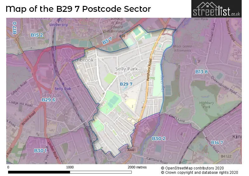
The B29 7 Postcode shares a border with B5 7 (BIRMINGHAM, Edgbaston), B13 8 (BIRMINGHAM, Moseley), B15 2 (BIRMINGHAM, Edgbaston), B29 6 (BIRMINGHAM, Selly Oak) and B30 2 (BIRMINGHAM, Stirchley, Bournville).
The sector is within the post town of BIRMINGHAM.
B29 7 is a postcode sector within the B29 postcode district which is within the B Birmingham postcode area.
The Royal Mail delivery office for the B29 7 postal sector is the Selly Oak Delivery Office.
The area of the B29 7 postcode sector is 0.76 square miles which is 1.97 square kilometres or 487.37 square acres.
Waterways within the B29 7 postcode sector include the River Rea, Bourn Brook, Worcester & Birmingham Canal.

Map of the B29 7 Postcode Sector
Explore the B29 7 postcode sector by using our free interactive map.
| B | 2 | 9 | - | 7 | X | X |
| B | 2 | 9 | Space | 7 | Letter | Letter |
Official List of Streets
BIRMINGHAM (29 Streets)
Bournbrook (2 Streets)
Selly Park (41 Streets)
Unofficial Streets or Alternative Spellings
BIRMINGHAM
EXETER ROAD MILL POOL WAY RADDLEBARN FARM DRIVE RIBBLESDALE ROADKings Norton
PERSHORE ROAD AVON PLACE BLOSSOM AVENUE HOLLY AVENUE HOLLY PLACE HOPE PLACE HOPE PLACE/UNITY PLACE LIME AVENUE MYRTLE PLACE PLAY PARK TRAIL UNITY PLACESelly Oak
BRISTOL ROAD RADDLEBARN ROADEdgbaston
ASTON WEBB BOULEVARDWeather Forecast for B29 7
Press Button to Show Forecast for Selly Oak
| Time Period | Icon | Description | Temperature | Rain Probability | Wind |
|---|---|---|---|---|---|
| 12:00 to 15:00 | Overcast | 9.0°C (feels like 7.0°C) | 13.00% | NW 9 mph | |
| 15:00 to 18:00 | Cloudy | 9.0°C (feels like 7.0°C) | 11.00% | N 9 mph | |
| 18:00 to 21:00 | Cloudy | 9.0°C (feels like 7.0°C) | 6.00% | NNE 7 mph | |
| 21:00 to 00:00 | Cloudy | 7.0°C (feels like 6.0°C) | 5.00% | ENE 4 mph |
Press Button to Show Forecast for Selly Oak
| Time Period | Icon | Description | Temperature | Rain Probability | Wind |
|---|---|---|---|---|---|
| 00:00 to 03:00 | Cloudy | 6.0°C (feels like 3.0°C) | 7.00% | E 7 mph | |
| 03:00 to 06:00 | Cloudy | 4.0°C (feels like 2.0°C) | 7.00% | E 4 mph | |
| 06:00 to 09:00 | Cloudy | 4.0°C (feels like 2.0°C) | 5.00% | ENE 4 mph | |
| 09:00 to 12:00 | Cloudy | 6.0°C (feels like 4.0°C) | 6.00% | E 7 mph | |
| 12:00 to 15:00 | Overcast | 8.0°C (feels like 7.0°C) | 11.00% | ENE 7 mph | |
| 15:00 to 18:00 | Overcast | 9.0°C (feels like 8.0°C) | 12.00% | E 7 mph | |
| 18:00 to 21:00 | Cloudy | 9.0°C (feels like 7.0°C) | 10.00% | ENE 7 mph | |
| 21:00 to 00:00 | Partly cloudy (night) | 7.0°C (feels like 4.0°C) | 9.00% | ENE 7 mph |
Press Button to Show Forecast for Selly Oak
| Time Period | Icon | Description | Temperature | Rain Probability | Wind |
|---|---|---|---|---|---|
| 00:00 to 03:00 | Cloudy | 5.0°C (feels like 3.0°C) | 12.00% | ENE 7 mph | |
| 03:00 to 06:00 | Cloudy | 4.0°C (feels like 2.0°C) | 13.00% | ENE 7 mph | |
| 06:00 to 09:00 | Cloudy | 4.0°C (feels like 2.0°C) | 14.00% | ENE 7 mph | |
| 09:00 to 12:00 | Cloudy | 7.0°C (feels like 4.0°C) | 19.00% | ENE 9 mph | |
| 12:00 to 15:00 | Light rain | 9.0°C (feels like 6.0°C) | 53.00% | ENE 9 mph | |
| 15:00 to 18:00 | Overcast | 10.0°C (feels like 7.0°C) | 23.00% | ENE 9 mph | |
| 18:00 to 21:00 | Cloudy | 9.0°C (feels like 7.0°C) | 19.00% | ENE 11 mph | |
| 21:00 to 00:00 | Cloudy | 8.0°C (feels like 5.0°C) | 22.00% | NE 11 mph |
Press Button to Show Forecast for Selly Oak
| Time Period | Icon | Description | Temperature | Rain Probability | Wind |
|---|---|---|---|---|---|
| 00:00 to 03:00 | Light rain | 7.0°C (feels like 4.0°C) | 52.00% | NE 9 mph | |
| 03:00 to 06:00 | Heavy rain | 6.0°C (feels like 4.0°C) | 71.00% | NE 9 mph | |
| 06:00 to 09:00 | Heavy rain | 7.0°C (feels like 4.0°C) | 73.00% | NE 9 mph | |
| 09:00 to 12:00 | Heavy rain | 8.0°C (feels like 6.0°C) | 75.00% | NNE 9 mph | |
| 12:00 to 15:00 | Light rain shower (day) | 10.0°C (feels like 8.0°C) | 43.00% | NNE 9 mph | |
| 15:00 to 18:00 | Heavy rain shower (day) | 11.0°C (feels like 9.0°C) | 59.00% | NW 9 mph | |
| 18:00 to 21:00 | Heavy rain shower (day) | 10.0°C (feels like 8.0°C) | 52.00% | NNW 9 mph | |
| 21:00 to 00:00 | Clear night | 8.0°C (feels like 7.0°C) | 11.00% | WNW 7 mph |
Schools and Places of Education Within the B29 7 Postcode Sector
Raddlebarn Primary School
Community school
Gristhorpe Road, Birmingham, West Midlands, B29 7TD
Head: Miss Angela Lowry
Ofsted Rating: Good
Inspection: 2018-07-17 (2109 days ago)
Website: Visit Raddlebarn Primary School Website
Phone: 01214720062
Number of Pupils: 424
Selly Park Girls' School
Community school
5 Selly Park Road, Birmingham, West Midlands, B29 7PH
Head: Mrs Lisa Darwood
Ofsted Rating: Good
Inspection: 2022-11-24 (518 days ago)
Website: Visit Selly Park Girls' School Website
Phone: 01214721238
Number of Pupils: 793
St Edward's Catholic Primary School
Voluntary aided school
Greenland Road, Birmingham, West Midlands, B29 7PN
Head: Mrs Joanne Kennett
Ofsted Rating: Good
Inspection: 2022-11-03 (539 days ago)
Website: Visit St Edward's Catholic Primary School Website
Phone: 01214641730
Number of Pupils: 405
House Prices in the B29 7 Postcode Sector
| Type of Property | 2018 Average | 2018 Sales | 2017 Average | 2017 Sales | 2016 Average | 2016 Sales | 2015 Average | 2015 Sales |
|---|---|---|---|---|---|---|---|---|
| Detached | £828,271 | 12 | £599,380 | 22 | £460,186 | 14 | £456,265 | 20 |
| Semi-Detached | £246,133 | 37 | £265,323 | 33 | £207,382 | 37 | £230,512 | 30 |
| Terraced | £226,493 | 100 | £228,650 | 105 | £205,588 | 115 | £203,528 | 126 |
| Flats | £138,806 | 8 | £139,458 | 12 | £122,370 | 10 | £119,480 | 10 |
Important Postcodes B29 7 in the Postcode Sector
B29 7DB is the postcode for Annexe St. Edwards RC School, Raddlebarn Road
B29 7DU is the postcode for Bournbrook Varsity Medical Practice, 1a Alton Road
B29 7HU is the postcode for Appledore Family Support Centre, Bourne House, 8 Serpentine Road
B29 7PH is the postcode for Sports Hall, Selly Park Girls School, 5 Selly Park Road, Selly Oak Local Authority, Selly Park Technology College, 5 Selly Park Road, New Science Building, Selly Park Girls School, 5 Selly Park Road, SPORTS HALL, Selly Oak Local Authority, Selly Park Technology College, 5 Selly Park Road, and Selly Park Girls School, 5 Selly Park Road
B29 7PN is the postcode for St Edwards Roman Catholic School, Greenland Road, Birmingham City Council, St. Edwards RC School, Greenland Road, Selly Oak Local Authority, St. Edwards RC School, Greenland Road, and ST EDWARDS ROMAN CATHOLIC SCHOOL, GREENLAND ROAD, BIRMINGHAM
B29 7QS is the postcode for 40, Woodside Road
B29 7TD is the postcode for Raddlebarn Primary & Nursery School, Gristhorpe Road
| The B29 7 Sector is within these Local Authorities |
|
|---|---|
| The B29 7 Sector is within these Counties |
|
| The B29 7 Sector is within these Water Company Areas |
|