B31 Postcode District
B31 is one of 46 Postcode Districts for the Birmingham Post town in West Midlands
The B31 postcode district is located in the B Birmingham postal area, B31 has a population of 58,045 residents according to the 2021 England and Wales Census..
The area of the district is 5.78 square miles (14.98 square kilometres or 3,701.06 acres).
A wide range of spatial data has been analysed to present this overview of B31. If you would like anything added, please contact us.
Map of B31
Explore the postcode district using the interactive map.
Larger circles indicate higher recorded crime totals.
On this page
District overview
The primary settlement in the B31 postcode district is Birmingham, which is located in the county of West Midlands. The most significant postal town within the B31 district is also Birmingham. There are other significant settlements in the district, including Northfield, which is also part of Birmingham in the county of West Midlands.
There are 6 postcode sectors within the district. Here's a breakdown:
The sector B31 1, covers Birmingham and Northfield in West Midlands.
The sector B31 2, covers Birmingham and Northfield in West Midlands.
The sector B31 3, covers Birmingham and Northfield in West Midlands.
The sector B31 4, covers Birmingham in West Midlands.
The sector B31 5, covers Birmingham and Northfield in West Midlands.
The sector B31 9 is non-geographic. It's often designated for PO Boxes, large organisations, or special services.
The post town for this district is BIRMINGHAM.
When it comes to local government, postal geography often disregards political borders. However, this district intersects the following councils: the district mostly encompasses the Birmingham District (B) (1146 postal codes), and finally, the Bromsgrove District area (5 postal codes).
Postcode sectors and neighbouring districts
Nearest towns
To help place the district geographically, here are nearby towns and their approximate direction from the district centre.
| Town | Distance (miles) | Direction |
|---|---|---|
| Halesowen | 4.81 | NW |
| Blackheath | 5.48 | NNW |
| Smethwick | 5.77 | N |
| Birmingham | 5.84 | NNE |
| Rowley Regis | 6.07 | NNW |
| Bromsgrove | 6.12 | SW |
| Oldbury | 6.97 | NNW |
| Brierley Hill | 7.07 | NW |
| Redditch | 7.09 | SSE |
| Stourbridge | 7.82 | WNW |
| West Bromwich | 7.85 | N |
| Solihull | 8.38 | E |
| Dudley | 8.43 | NNW |
| Tipton | 9.65 | NNW |
| Wednesbury | 10.17 | N |
| Kingswinford | 10.18 | NW |
| Coseley | 10.44 | NNW |
| Sedgley | 11.14 | NNW |
| Darlaston | 11.43 | NNW |
| Henley-in-Arden | 11.49 | SE |
Postcode information
Total geographical postcodes: 1,584
| Location | Post Town | Sector | Number of postcodes |
|---|---|---|---|
| BIRMINGHAM | BIRMINGHAM | B31 4 | 204 |
| BIRMINGHAM | BIRMINGHAM | B31 2 | 187 |
| BIRMINGHAM | BIRMINGHAM | B31 1 | 181 |
| BIRMINGHAM | BIRMINGHAM | B31 3 | 180 |
| BIRMINGHAM | BIRMINGHAM | B31 5 | 146 |
| Northfield | BIRMINGHAM | B31 2 | 92 |
| Northfield | BIRMINGHAM | B31 2 | 90 |
| BIRMINGHAM | BIRMINGHAM | B31 2 | 73 |
| BIRMINGHAM | BIRMINGHAM | B31 1 | 60 |
| BIRMINGHAM | BIRMINGHAM | B31 3 | 50 |
| Northfield | BIRMINGHAM | B31 3 | 43 |
| Northfield | BIRMINGHAM | B31 3 | 40 |
| Northfield | BIRMINGHAM | B31 1 | 39 |
| BIRMINGHAM | BIRMINGHAM | B31 5 | 34 |
| Northfield | BIRMINGHAM | B31 1 | 28 |
| Northfield | BIRMINGHAM | B31 5 | 26 |
| Northfield | BIRMINGHAM | B31 5 | 23 |
| BIRMINGHAM | BIRMINGHAM | B31 4 | 19 |
| Northfield | BIRMINGHAM | B31 4 | 16 |
| BIRMINGHAM | BIRMINGHAM | B31 5 | 14 |
| BIRMINGHAM | BIRMINGHAM | B31 2 | 7 |
| Northfield | BIRMINGHAM | B31 4 | 7 |
| BIRMINGHAM | BIRMINGHAM | B31 3 | 5 |
| BIRMINGHAM | BIRMINGHAM | B31 4 | 4 |
| Northfield | BIRMINGHAM | B31 5 | 4 |
| BIRMINGHAM | BIRMINGHAM | B31 5 | 2 |
| Northfield | BIRMINGHAM | B31 3 | 2 |
| BIRMINGHAM | BIRMINGHAM | B31 4 | 2 |
| BIRMINGHAM | BIRMINGHAM | B31 4 | 1 |
| Northfield | BIRMINGHAM | B31 4 | 1 |
| Northfield | BIRMINGHAM | B31 4 | 1 |
| Northfield | BIRMINGHAM | B31 4 | 1 |
| BIRMINGHAM | BIRMINGHAM | B31 2 | 1 |
| BIRMINGHAM | BIRMINGHAM | B31 2 | 1 |
Street list for B31
Crime overview
Top streets by recorded crime
| Street | Crime count |
|---|---|
| BRISTOL ROAD SOUTH | 906 |
| NEWLYN ROAD | 381 |
| HIGH STREET | 309 |
| ROCHESTER ROAD | 286 |
| THE GREEN | 188 |
| GROSVENOR SHOPPING PRECINCT | 186 |
| ABBEYDALE ROAD | 176 |
| ABBEYDALE ROAD | 176 |
| EDEN CLOSE | 166 |
| DALMUIR ROAD | 146 |
Most common crime types
| Crime type | Count |
|---|---|
| Violence and sexual offences | 6618 |
| Shoplifting | 1675 |
| Vehicle crime | 1370 |
| Criminal damage and arson | 1281 |
| Public order | 879 |
| Other theft | 773 |
| Burglary | 727 |
| Possession of weapons | 357 |
| Robbery | 352 |
| Drugs | 318 |
| Other crime | 308 |
| Theft from the person | 80 |
| Bicycle theft | 45 |
Retail and shopping
| Street | Town | Locality | Number of shops | Central postcode | Map |
|---|---|---|---|---|---|
| BRISTOL ROAD SOUTH | BIRMINGHAM | 256 | B31 2NS | View map | |
| ALVECHURCH ROAD | BIRMINGHAM | 22 | B31 3JW | View map | |
| HIGH STREET | BIRMINGHAM | LONGBRIDGE | 18 | B31 2UQ | View map |
| FAIRFAX ROAD | BIRMINGHAM | 15 | B31 3SH | View map | |
| WYCHALL ROAD | BIRMINGHAM | 15 | B31 3AU | View map | |
| LONGBRIDGE LANE | BIRMINGHAM | 11 | B31 4LF | View map | |
| MERRITTS BROOK LANE | BIRMINGHAM | 11 | B31 1UJ | View map | |
| TURVES GREEN | BIRMINGHAM | 9 | B31 4BL | View map | |
| WEST HEATH ROAD | BIRMINGHAM | NORTHFIELD | 9 | B31 3TG | View map |
| HILLWOOD ROAD | BIRMINGHAM | 8 | B31 1DJ | View map | |
| FRANKLEY BEECHES ROAD | BIRMINGHAM | 7 | B31 5AA | View map | |
| SUNBURY ROAD | BIRMINGHAM | 7 | B31 4LJ | View map | |
| CHURCH HILL | BIRMINGHAM | NORTHFIELD | 6 | B31 3UB | View map |
| HIGH STREET | BIRMINGHAM | 6 | B31 2UQ | View map |
Schools in the district
Woodcock Hill Primary School
Phase: Primary
Address:
Farwood Road , Northfield , Birmingham
Postcode: B31 1BS
Headteacher: Mr Derek Higgins (Headteacher)
Ofsted rating: Good
Shenley Fields Nursery School
Phase: Nursery
Address:
Woodcock Lane , Northfield , Birmingham
Postcode: B31 1BU
Headteacher: Mr David Aldworth (Headteacher)
Ofsted rating: Outstanding
Victoria School
Phase: Not applicable
Address:
Bell Hill , Northfield , Birmingham
Postcode: B31 1LD
Headteacher: Mr Gary Coffey (Executive Headteacher)
Ofsted rating: Outstanding
Longwill A Primary School for Deaf Children
Phase: Not applicable
Address:
Bell Hill , Northfield , Birmingham
Postcode: B31 1LD
Headteacher: Mrs Alison Carter (Headteacher)
Ofsted rating: Outstanding
Victoria College
Phase: Not applicable
Address:
Bell Hill , Northfield , Birmingham
Postcode: B31 1LD
Headteacher: Mr Gary Coffey
Ofsted rating: Requires improvement
Bellfield Infant School (NC)
Phase: Primary
Address:
Vineyard Road , Birmingham
Postcode: B31 1PT
Headteacher: Mr Joseph McCabe (Headteacher)
Ofsted rating: Good
Bellfield Junior School
Phase: Primary
Address:
Vineyard Road , Northfield , Birmingham
Postcode: B31 1PT
Headteacher: Mr Nigel Attwood (Headteacher)
Ofsted rating: Good
The Orchards Primary Academy
Phase: Primary
Address:
Rhayader Road , Northfield , Birmingham
Postcode: B31 1TX
Headteacher: Mrs Beverley Walker-Gordon (Headteacher)
Ofsted rating: Good
St Laurence Church Junior School
Phase: Primary
Address:
Bunbury Road , Northfield , Birmingham
Postcode: B31 2DJ
Headteacher: Mr Andrew Murphy (Headteacher)
Ofsted rating: Good
St Laurence Church Infant School
Phase: Primary
Address:
Bunbury Road , Northfield , Birmingham
Postcode: B31 2DJ
Headteacher: Mrs Catherine Smith (Headteacher)
Ofsted rating: Good
The Edge Academy
Phase: Not applicable
Address:
946, Bristol Road South , Northfield , Birmingham
Postcode: B31 2LQ
Headteacher: Mr Adam Smith (Interim Headteacher)
Ofsted rating: Good
The Meadows Primary School
Phase: Primary
Address:
Bristol Road South , Northfield , Bristol Road South, Northfield , Birmingham
Postcode: B31 2SW
Headteacher: Miss Di Waeland (Acting Headteacher)
Ofsted rating: Requires improvement
Wychall Primary School
Phase: Primary
Address:
Middle Field Road , Northfield , Birmingham
Postcode: B31 3EH
Headteacher: Headteacher Nick Lamorte (Headteacher)
Ofsted rating: Good
West Heath Nursery School
Phase: Nursery
Address:
200 West Heath Road , Northfield , Birmingham
Postcode: B31 3HB
Headteacher: Mrs Jacqueline Jackson (Headteacher)
Ofsted rating: Good
St John Fisher Catholic Primary School
Phase: Primary
Address:
Alvechurch Road , West Heath , Birmingham
Postcode: B31 3PN
Headteacher: Mrs Leanne Rogers (Headteacher)
Ofsted rating: Good
St John Fisher Catholic Primary School
Phase: Primary
Address:
Alvechurch Road , West Heath , Birmingham
Postcode: B31 3PN
Headteacher: Mrs Leanne Rogers (Headteacher)
Ofsted rating: Good
Turves Green Primary School
Phase: Primary
Address:
Northfield , Birmingham
Postcode: B31 4BP
Headteacher: Mr Jon Gale (Executive Headteacher)
Ofsted rating: Special Measures
Turves Green Girls' School
Phase: Secondary
Address:
Turves Green , Northfield , Birmingham
Postcode: B31 4BP
Headteacher: Mr Neil Jones (Headteacher)
Ofsted rating: Good
Turves Green Primary School
Phase: Primary
Address:
Northfield , Birmingham
Postcode: B31 4BP
Headteacher: Mrs Debbie Holland (Ceo /Executive Headteacher)
Ofsted rating: Good
Turves Green Boys' School
Phase: Secondary
Address:
Turves Green , Northfield , Birmingham
Postcode: B31 4BS
Headteacher: Mr James Till (Headteacher)
Ofsted rating: Special Measures
Albert Bradbeer Primary Academy
Phase: Primary
Address:
Turves Green , Longbridge , Birmingham
Postcode: B31 4RD
Headteacher: Miss Christine Nock (Headteacher)
Ofsted rating: Good
Cofton Primary School
Phase: Primary
Address:
Wootton Road , West Heath , Birmingham
Postcode: B31 4ST
Headteacher: Mrs Deborah Dudt (Headteacher)
Ofsted rating: Good
St Brigid's Catholic Primary School
Phase: Primary
Address:
Frankley Beeches Road , Northfield , Birmingham
Postcode: B31 5AB
Headteacher: Mrs Caroline Chapman (Headteacher)
Ofsted rating: Good
Merritts Brook Primary E-ACT Academy
Phase: Primary
Address:
Trescott Road , Northfield , Birmingham
Postcode: B31 5QD
Headteacher: Mrs Joanne Hall (Principal)
Ofsted rating: Good
Healthcare services
| # | Name | Address | Type | Contact |
|---|---|---|---|---|
| 1 | House Of Dental | 31 REDHILL ROAD, NORTHFIELD, BIRMINGHAM, WEST MIDLANDS, B31 3JS | GENERAL DENTAL PRACTICE | No contact details listed |
| 2 | Dental Surgery | 58 BUNBURY ROAD, BIRMINGHAM, WEST MIDLANDS, B31 2DW | GENERAL DENTAL PRACTICE | No contact details listed |
| 3 | Dental Surgery | 990 BRISTOL ROAD SOUTH, NORTHFIELD, BIRMINGHAM, WEST MIDLANDS, B31 2PE | GENERAL DENTAL PRACTICE | No contact details listed |
| 4 | Hilltop Dental Spa | 1007 BRISTOL ROAD SOUTH, NORTHFIELD, BIRMINGHAM, B31 2QT | GENERAL DENTAL PRACTICE | No contact details listed |
| 5 | Dental Surgery | 225 LONGBRIDGE LANE, BIRMINGHAM, WEST MIDLANDS, B31 4RE | GENERAL DENTAL PRACTICE | No contact details listed |
| 6 | Hollymoor Tower Dental Surgery | MANOR PARK GROVE, NORTHFIELD, BIRMINGHAM, WEST MIDLANDS, B31 5ER | GENERAL DENTAL PRACTICE | No contact details listed |
| 7 | Northfield Health Centre | 15 ST HELIERS ROAD, BIRMINGHAM, WEST MIDLANDS, B31 1QT | GENERAL DENTAL PRACTICE | No contact details listed |
Data accessed from NHS Digital and updated monthly.
| # | Name | Address | Type | Contact |
|---|---|---|---|---|
| 1 | West Heath Surgery | 196 WEST HEATH ROAD, NORTHFIELD, BIRMINGHAM, WEST MIDLANDS, B31 3HB | GP PRACTICE | Call 0121 4761135 |
| 2 | College Green Medical Practice | HEALTH & WELLBEING CENTRE, 1 BRISTOL ROAD SOUTH, BIRMINGHAM, WEST MIDLANDS, B31 2GH | GP PRACTICE | Call 01212 030200 |
| 3 | St Heliers Medical Practice | 15 ST. HELIERS ROAD, BIRMINGHAM, B31 1QT | GP PRACTICE | Call 0121 4781850 |
| 4 | Woodland Road Surgery | 57 WOODLAND ROAD, NORTHFIELD, BIRMINGHAM, WEST MIDLANDS, B31 2HZ | GP PRACTICE | Call 0121 4751065 |
| 5 | Great Park Medical Group | MANOR PARK GROVE, NORTHFIELD, BIRMINGHAM, WEST MIDLANDS, B31 5ER | GP PRACTICE | Call 0121 4769191 |
| 6 | Cofton Medical Centre | 2 ROBINSFIELD DRIVE, BIRMINGHAM, WEST MIDLANDS, B31 4TU | GP PRACTICE | Call 0121 6935777 |
| 7 | Doski Medical Practice | 101 HOLLOWAY, NORTHFIELD, BIRMINGHAM, WEST MIDLANDS, B31 1TR | GP PRACTICE | Call 0121 4751422 |
| 8 | West Heath Surgery - Covid Local Vaccination Service 2 | 196 WEST HEATH ROAD, NORTHFIELD, BIRMINGHAM, B31 3HB | BRANCH SURGERY | No contact details listed |
| 9 | St Heliers Medical Practice - Covid Local Vaccination Service 2 | 15 ST HELIERS ROAD, BIRMINGHAM, B31 1QT | BRANCH SURGERY | No contact details listed |
Data accessed from NHS Digital and updated monthly.
| # | Name | Address | Type | Contact |
|---|---|---|---|---|
| 1 | Boots | 1 MIDDLEMORE ROAD, NORTHFIELD, BIRMINGHAM, WEST MIDLANDS, B31 3UD | PHARMACY | Call 0121 6043000 |
| 2 | Clock Pharmacy | 827 BRISTOL ROAD SOUTH, NORTHFIELD, BIRMINGHAM, WEST MIDLANDS, B31 2PA | PHARMACY | Call 0121 4774646 |
| 3 | Knights West Heath Pharmacy | 5 ALVECHURCH ROAD, WEST HEATH, BIRMINGHAM, WEST MIDLANDS, B31 3JW | PHARMACY | Call 01214 770123 |
| 4 | G R Pharmacy | HILLWOOD ROAD, BIRMINGHAM, WEST MIDLANDS, B31 1DJ | PHARMACY | Call 0121 4752556 |
| 5 | Knights Royston Hall Pharmacy | 15 ST HELIERS ROAD, NORTHFIELD, BIRMINGHAM, WEST MIDLANDS, B31 1QT | PHARMACY | Call 01214 754427 |
| 6 | Superdrug Pharmacy | 26-28 GROSVENOR SHOPPING CENTRE, NORTHFIELD, BIRMINGHAM, WEST MIDLANDS, B31 2JU | PHARMACY | Call 0121 4773845 |
| 7 | Knights Longbridge Pharmacy | 4 SUNBURY ROAD, LONGBRIDGE, BIRMINGHAM, WEST MIDLANDS, B31 4LJ | PHARMACY | Call 01214 752655 |
| 8 | Pitman Pharmacy | 622 BRISTOL ROAD SOUTH, NORTHFIELD, BIRMINGHAM, WEST MIDLANDS, B31 2JR | PHARMACY | Call 0121 4762276 |
| 9 | Hingley Chemist | MANOR PARK GROVE, NORTHFIELD, BIRMINGHAM, WEST MIDLANDS, B31 5ER | PHARMACY | Call 0121 4530055 |
| 10 | Browns Pharmacy | 228-230 WYCHALL ROAD, NORTHFIELD, BIRMINGHAM, B31 3AU | PHARMACY | Call 01214 581119 |
| 11 | Redhill Pharmacy | 11 ALVECHURCH ROAD, WEST HEATH, BIRMINGHAM, B31 3JP | PHARMACY | Call 01214 752790 |
Data accessed from NHS Digital and updated monthly.
| # | Name | Address | Type | Contact |
|---|---|---|---|---|
| 1 | Scrivens Opticians (northfield) | 731 BRISTOL ROAD SOUTH, NORTHFIELD, BIRMINGHAM, WEST MIDLANDS, B31 2NG | OPTICAL SITE | No contact details listed |
| 2 | Specsavers (northfield, Birmingham) | 790-792 BRISTOL ROAD SOUTH, NORTHFIELD, BIRMINGHAM, WEST MIDLANDS, B31 2NN | OPTICAL SITE | No contact details listed |
| 3 | Boots Opticians (northfield) | 816 BRISTOL ROAD SOUTH, NORTHFIELD, BIRMINGHAM, WEST MIDLANDS, B31 2NS | OPTICAL SITE | No contact details listed |
| 4 | The Eye Collective | 892 BRISTOL ROAD SOUTH, NORTHFIELD, BIRMINGHAM, WEST MIDLANDS, B31 2NS | OPTICAL SITE | No contact details listed |
| 5 | Specsavers Opticians (longbridge) | LONGBRIDGE TOWN CENTRE, 11 HIGH STREET, NORTHFIELD, BIRMINGHAM, WEST MIDLANDS, B31 2UQ | OPTICAL SITE | No contact details listed |
| 6 | Mattoo Davinder (heliers Road) | NORTHFIELD HEALTH CENTRE, 15 ST. HELIERS ROAD, BIRMINGHAM, WEST MIDLANDS, B31 1QT | OPTICAL SITE | No contact details listed |
| 7 | Specs Direct (bristol Road) | 871 BRISTOL ROAD SOUTH, NORTHFIELD, BIRMINGHAM, B31 2PA | OPTICAL SITE | No contact details listed |
| 8 | The Eye Collective (west Heath) Ltd | 3 ALVECHURCH ROAD, BIRMINGHAM, B31 3JW | OPTICAL SITE | No contact details listed |
| 9 | M&s Opticians - Longbridge | 20 HIGH STREET, NORTHFIELD, BIRMINGHAM, B31 2UQ | OPTICAL SITE | No contact details listed |
| 10 | Acton & Lloyds Limited | 826 BRISTOL ROAD SOUTH, NORTHFIELD, BIRMINGHAM, B31 2NS | OPTICAL SITE | No contact details listed |
Data accessed from NHS Digital and updated monthly.
Property and housing
Yearly house price averages for the district
| Type of property | 2025 average | 2025 sales | 2024 average | 2024 sales | 2023 average | 2023 sales | 2022 average | 2022 sales |
|---|---|---|---|---|---|---|---|---|
| Detached | £364,446 | 94 | £380,794 | 85 | £386,567 | 73 | £344,158 | 89 |
| Semi-detached | £259,313 | 294 | £251,590 | 370 | £243,951 | 320 | £244,649 | 411 |
| Terraced | £211,579 | 236 | £215,206 | 246 | £199,483 | 236 | £200,517 | 263 |
| Flats | £144,102 | 103 | £153,529 | 125 | £156,854 | 134 | £168,233 | 241 |
Transport and connectivity
Stations in the district
Northfield
CRS Code: NFD
Operator: WM
Line: Bristol to Brimingham Line
Company:
Longbridge
CRS Code: LOB
Operator: WM
Line: Bristol to Brimingham Line
Company:
Accessible motorway junctions
M42 J2
Average Driving Time from within the district: 7.38
Average Driving Distance: 4.03
Number of Postcodes that can access the Motorway Junction: 1135
M5 J4
Average Driving Time from within the district: 7.47
Average Driving Distance: 4.59
Number of Postcodes that can access the Motorway Junction: 1135
M42 J3
Average Driving Time from within the district: 8.80
Average Driving Distance: 6.04
Number of Postcodes that can access the Motorway Junction: 663
M42 J1
Average Driving Time from within the district: 9.61
Average Driving Distance: 6.17
Number of Postcodes that can access the Motorway Junction: 1039
M5 J2
Average Driving Time from within the district: 10.68
Average Driving Distance: 6.27
Number of Postcodes that can access the Motorway Junction: 261
M5 J3
Average Driving Time from within the district: 10.79
Average Driving Distance: 6.20
Number of Postcodes that can access the Motorway Junction: 1134
M5 J1
Average Driving Time from within the district: 11.12
Average Driving Distance: 6.59
Number of Postcodes that can access the Motorway Junction: 62
Royal Mail delivery and sorting offices
| Postal sector | Delivery office |
|---|---|
| B31 1 | Northfield Delivery Office |
| B31 2 | Northfield Delivery Office |
| B31 3 | Northfield Delivery Office |
| B31 4 | Northfield Delivery Office |
| B31 5 | Northfield Delivery Office |
Postcode format
| B | 3 | 1 | - | X | X | X |
| B | 3 | 1 | Space | Numeric | Letter | Letter |
Administrative and boundary notes
The largest settlements in the B31 postal code are BIRMINGHAM and Northfield.
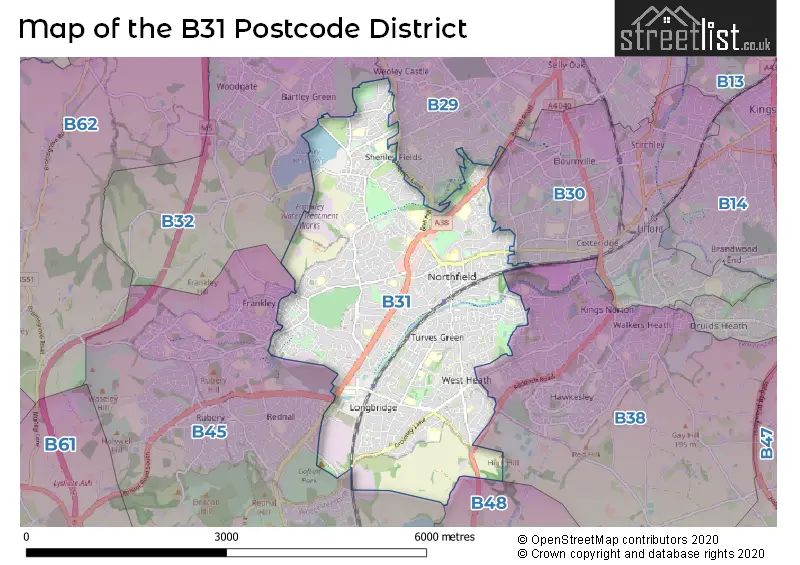
The B31 Postcode shares a border with B29 (BIRMINGHAM, Selly Oak, Selly Park), B30 (BIRMINGHAM, Kings Norton, Stirchley), B32 (BIRMINGHAM, Quinton, Harborne), B48 (Alvechurch, Portway), B38 (BIRMINGHAM, Kings Norton) and B45 (Rednal, Barnt Green, Cofton Hackett).
Maps and visuals
Weather
Weather Forecast for Northfield (West Midlands)
Powered by Met Office DataPoint under the Open Government Licence.