The B31 4 postcode sector stands on the West Midlands and Worcestershire border.
Did you know? According to the 2021 Census, the B31 4 postcode sector is home to a bustling 10,338 residents!
Given that each sector allows for 400 unique postcode combinations. Letters C, I, K, M, O and V are not allowed in the last two letters of a postcode. With 223 postcodes already in use, this leaves 177 units available.
The largest settlements in the B31 4 postal code are BIRMINGHAM and Northfield.
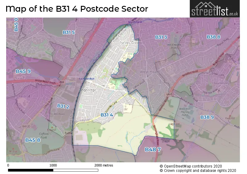
The B31 4 Postcode shares a border with B31 2 (BIRMINGHAM, Northfield), B48 7 (Alvechurch, Portway), B31 3 (BIRMINGHAM, Northfield), B38 8 (BIRMINGHAM, Kings Norton), B38 9 (BIRMINGHAM, Kings Norton) and B45 8 (Rednal, Barnt Green, Cofton Hackett).
The sector is within the post town of BIRMINGHAM.
B31 4 is a postcode sector within the B31 postcode district which is within the B Birmingham postcode area.
The Royal Mail delivery office for the B31 4 postal sector is the Northfield Delivery Office.
The area of the B31 4 postcode sector is 1.28 square miles which is 3.31 square kilometres or 816.92 square acres.
Waterways within the B31 4 postcode sector include the River Rea.

Map of the B31 4 Postcode Sector
Explore the B31 4 postcode sector by using our free interactive map.
| B | 3 | 1 | - | 4 | X | X |
| B | 3 | 1 | Space | 4 | Letter | Letter |
Official List of Streets
BIRMINGHAM (81 Streets)
Unofficial Streets or Alternative Spellings
BIRMINGHAM
ABBEYDALE ROAD BEECHES WAY CLUNBURY ROAD COFTON ROAD FAIRFAX ROAD GREENSLADE CROFT HAWKESLEY MILL LANE KELVIN ROAD LAUGHTON CLOSE PETERS AVENUE QUARRY LANE STEEL ROAD TESSALL LANENorthfield
MILL LANE REA ROAD STATION ROADKings Norton
REDDITCH ROADCofton Hackett
GROVELEY LANEAlvechurch
BIRMINGHAM ROAD CULMINGTON GROVE KINGSWOOD WALK REA VALLEY ROUTEWeather Forecast for B31 4
Press Button to Show Forecast for Longbridge
| Time Period | Icon | Description | Temperature | Rain Probability | Wind |
|---|---|---|---|---|---|
| 06:00 to 09:00 | Cloudy | 5.0°C (feels like 2.0°C) | 9.00% | WSW 7 mph | |
| 09:00 to 12:00 | Cloudy | 7.0°C (feels like 5.0°C) | 7.00% | NW 9 mph | |
| 12:00 to 15:00 | Overcast | 9.0°C (feels like 6.0°C) | 15.00% | NW 9 mph | |
| 15:00 to 18:00 | Cloudy | 9.0°C (feels like 6.0°C) | 7.00% | N 9 mph | |
| 18:00 to 21:00 | Cloudy | 8.0°C (feels like 6.0°C) | 7.00% | NNE 7 mph | |
| 21:00 to 00:00 | Cloudy | 7.0°C (feels like 5.0°C) | 4.00% | ENE 4 mph |
Press Button to Show Forecast for Longbridge
| Time Period | Icon | Description | Temperature | Rain Probability | Wind |
|---|---|---|---|---|---|
| 00:00 to 03:00 | Cloudy | 5.0°C (feels like 3.0°C) | 9.00% | E 7 mph | |
| 03:00 to 06:00 | Cloudy | 4.0°C (feels like 2.0°C) | 7.00% | E 7 mph | |
| 06:00 to 09:00 | Cloudy | 4.0°C (feels like 1.0°C) | 6.00% | ENE 7 mph | |
| 09:00 to 12:00 | Cloudy | 6.0°C (feels like 3.0°C) | 6.00% | ENE 7 mph | |
| 12:00 to 15:00 | Overcast | 8.0°C (feels like 6.0°C) | 12.00% | ENE 7 mph | |
| 15:00 to 18:00 | Cloudy | 9.0°C (feels like 8.0°C) | 9.00% | ENE 7 mph | |
| 18:00 to 21:00 | Cloudy | 8.0°C (feels like 6.0°C) | 10.00% | E 7 mph | |
| 21:00 to 00:00 | Cloudy | 6.0°C (feels like 4.0°C) | 12.00% | ENE 9 mph |
Press Button to Show Forecast for Longbridge
| Time Period | Icon | Description | Temperature | Rain Probability | Wind |
|---|---|---|---|---|---|
| 00:00 to 03:00 | Cloudy | 5.0°C (feels like 2.0°C) | 11.00% | ENE 9 mph | |
| 03:00 to 06:00 | Cloudy | 4.0°C (feels like 1.0°C) | 12.00% | ENE 9 mph | |
| 06:00 to 09:00 | Cloudy | 4.0°C (feels like 1.0°C) | 13.00% | ENE 9 mph | |
| 09:00 to 12:00 | Cloudy | 6.0°C (feels like 3.0°C) | 17.00% | ENE 11 mph | |
| 12:00 to 15:00 | Light rain | 8.0°C (feels like 5.0°C) | 50.00% | ENE 11 mph | |
| 15:00 to 18:00 | Overcast | 9.0°C (feels like 7.0°C) | 23.00% | ENE 11 mph | |
| 18:00 to 21:00 | Cloudy | 9.0°C (feels like 6.0°C) | 18.00% | ENE 11 mph | |
| 21:00 to 00:00 | Cloudy | 7.0°C (feels like 4.0°C) | 22.00% | NE 11 mph |
Press Button to Show Forecast for Longbridge
| Time Period | Icon | Description | Temperature | Rain Probability | Wind |
|---|---|---|---|---|---|
| 00:00 to 03:00 | Light rain | 6.0°C (feels like 3.0°C) | 52.00% | NE 11 mph | |
| 03:00 to 06:00 | Heavy rain | 6.0°C (feels like 3.0°C) | 71.00% | NE 11 mph | |
| 06:00 to 09:00 | Heavy rain | 6.0°C (feels like 3.0°C) | 76.00% | NE 11 mph | |
| 09:00 to 12:00 | Heavy rain | 8.0°C (feels like 5.0°C) | 76.00% | NNE 11 mph | |
| 12:00 to 15:00 | Light rain | 9.0°C (feels like 7.0°C) | 49.00% | ENE 11 mph | |
| 15:00 to 18:00 | Heavy rain shower (day) | 10.0°C (feels like 8.0°C) | 60.00% | NNW 11 mph | |
| 18:00 to 21:00 | Light rain shower (day) | 10.0°C (feels like 8.0°C) | 40.00% | NNE 9 mph | |
| 21:00 to 00:00 | Partly cloudy (night) | 8.0°C (feels like 5.0°C) | 10.00% | N 9 mph |
Schools and Places of Education Within the B31 4 Postcode Sector
Albert Bradbeer Primary Academy
Academy converter
Turves Green, Birmingham, West Midlands, B31 4RD
Head: Miss Christine Nock
Ofsted Rating: Good
Inspection: 2019-10-10 (1659 days ago)
Website: Visit Albert Bradbeer Primary Academy Website
Phone: 01214642356
Number of Pupils: 435
Cofton Primary School
Foundation school
Wootton Road, Birmingham, West Midlands, B31 4ST
Head: Mrs Deborah Dudt
Ofsted Rating: Good
Inspection: 2020-01-16 (1561 days ago)
Website: Visit Cofton Primary School Website
Phone: 01214753374
Number of Pupils: 408
Turves Green Primary School
Academy sponsor led
Northfield, Birmingham, West Midlands, B31 4BP
Head: Mrs Debbie Holland
Ofsted Rating: Good
Inspection: 2020-02-26 (1520 days ago)
Website: Visit Turves Green Primary School Website
Phone: 01214643686
Number of Pupils: 380
House Prices in the B31 4 Postcode Sector
| Type of Property | 2018 Average | 2018 Sales | 2017 Average | 2017 Sales | 2016 Average | 2016 Sales | 2015 Average | 2015 Sales |
|---|---|---|---|---|---|---|---|---|
| Detached | £172,357 | 14 | £164,090 | 20 | £144,235 | 17 | £143,917 | 30 |
| Semi-Detached | £158,411 | 78 | £150,790 | 67 | £142,526 | 70 | £132,183 | 62 |
| Terraced | £145,097 | 54 | £132,012 | 55 | £128,693 | 41 | £117,202 | 48 |
| Flats | £95,306 | 16 | £95,097 | 16 | £87,555 | 14 | £81,500 | 12 |
Important Postcodes B31 4 in the Postcode Sector
B31 4BP is the postcode for BIRMINGHAM CITY COUNCIL MAIN BLOCK, Turves Green Girls School, 117 Turves Green, Turves Green Primary School, Turves Green Road, King Edwards VI Northfield Girls School, Turves Green, WEST BLOCK, Turves Green Girls School, 117 Turves Green, Turves Green Girls School, 117 Turves Green, MAIN BLOCK, Turves Green Girls School, 117 Turves Green, BIRMINGHAM CITY COUNCIL WEST BLOCK, Turves Green Girls School, 117 Turves Green, and BIRMINGHAM CITY COUNCIL, TECHNOLOGY BLOCK, Turves Green Girls School, 117 Turves Green
B31 4BS is the postcode for BIRMINGHAM CITY COUNCIL, Turves Green Boys School, Turves Green, Turves Green Boys School, Turves Green, and Sports Centre, Turves Green Boys School, Turves Green
B31 4RD is the postcode for JUNIORS BUILDING, Birmingham City Council, Albert Bradbeer Infants School, Albert Bradbeer Junior School, Longbridge Lane, Albert Bradbeer Primary, Longbridge Lane, JUNIORS BUILDING, Albert Bradbeer Primary Academy, Longbridge Lane, SURE START NURSERY, Birmingham City Council, Albert Bradbeer Infants School, Birmingham City Council, Albert Bradbeer Infants School, and BIRMINGHAM CITY COUNCIL, Albert Bradbeer Junior School, Longbridge Lane
B31 4ST is the postcode for Dinning Room, Cofton Primary School, Wootton Road, Reception Classes, Cofton Primary School, Wootton Road, Juniors Building, Cofton Primary School, Wootton Road, Infants Building, Cofton Primary School, Wootton Road, and Cofton Primary School, Wootton Road
B31 4TU is the postcode for Cofton Medical Centre, 2 Robinsfield Drive
| The B31 4 Sector is within these Local Authorities |
|
|---|---|
| The B31 4 Sector is within these Counties |
|
| The B31 4 Sector is within these Water Company Areas |
|