The B34 7 postcode sector is within the county of West Midlands.
Did you know? According to the 2021 Census, the B34 7 postcode sector is home to a bustling 8,868 residents!
Given that each sector allows for 400 unique postcode combinations. Letters C, I, K, M, O and V are not allowed in the last two letters of a postcode. With 151 postcodes already in use, this leaves 249 units available.
The B34 7 postal code covers the settlement of BIRMINGHAM.
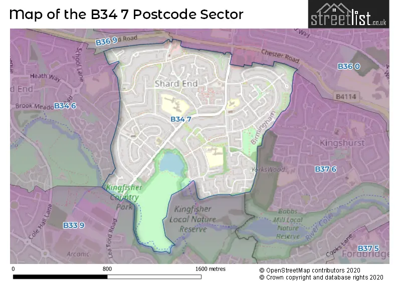
The B34 7 Postcode shares a border with B33 9 (BIRMINGHAM, Stechford, Kitts Green), B36 0 (BIRMINGHAM, Castle Bromwich, Kingshurst), B36 9 (BIRMINGHAM, Castle Bromwich), B37 6 (BIRMINGHAM, Kingshurst, Chelmsley Wood) and B34 6 (BIRMINGHAM, Shard End, Buckland End).
The sector is within the post town of BIRMINGHAM.
B34 7 is a postcode sector within the B34 postcode district which is within the B Birmingham postcode area.
The Royal Mail delivery office for the B34 7 postal sector is the Kitts Green Delivery Office.
The area of the B34 7 postcode sector is 0.68 square miles which is 1.77 square kilometres or 437.54 square acres.
Waterways within the B34 7 postcode sector include the River Cole.

Map of the B34 7 Postcode Sector
Explore the B34 7 postcode sector by using our free interactive map.
| B | 3 | 4 | - | 7 | X | X |
| B | 3 | 4 | Space | 7 | Letter | Letter |
Official List of Streets
BIRMINGHAM (71 Streets)
Unofficial Streets or Alternative Spellings
Castle Bromwich
BROOM CLOSE CHESTER ROADKingshurst
SILVER BIRCH ROADBIRMINGHAM
HEATH WAY HURST LANE NORTH LEA FORD ROAD PENCROFT ROADShard End
PEAR TREE ROAD FREEMANTLE DRIVEWeather Forecast for B34 7
Press Button to Show Forecast for Shard End
| Time Period | Icon | Description | Temperature | Rain Probability | Wind |
|---|---|---|---|---|---|
| 15:00 to 18:00 | Cloudy | 10.0°C (feels like 8.0°C) | 39.00% | N 13 mph | |
| 18:00 to 21:00 | Cloudy | 9.0°C (feels like 7.0°C) | 31.00% | NNE 9 mph | |
| 21:00 to 00:00 | Cloudy | 8.0°C (feels like 6.0°C) | 5.00% | NE 7 mph |
Press Button to Show Forecast for Shard End
| Time Period | Icon | Description | Temperature | Rain Probability | Wind |
|---|---|---|---|---|---|
| 00:00 to 03:00 | Cloudy | 5.0°C (feels like 4.0°C) | 4.00% | NNE 4 mph | |
| 03:00 to 06:00 | Cloudy | 5.0°C (feels like 3.0°C) | 3.00% | NNW 4 mph | |
| 06:00 to 09:00 | Partly cloudy (day) | 5.0°C (feels like 3.0°C) | 0.00% | NNW 4 mph | |
| 09:00 to 12:00 | Cloudy | 7.0°C (feels like 5.0°C) | 4.00% | N 7 mph | |
| 12:00 to 15:00 | Cloudy | 10.0°C (feels like 8.0°C) | 5.00% | N 7 mph | |
| 15:00 to 18:00 | Cloudy | 11.0°C (feels like 9.0°C) | 5.00% | NNE 9 mph | |
| 18:00 to 21:00 | Cloudy | 10.0°C (feels like 9.0°C) | 5.00% | NNE 7 mph | |
| 21:00 to 00:00 | Cloudy | 8.0°C (feels like 7.0°C) | 4.00% | NNE 4 mph |
Press Button to Show Forecast for Shard End
| Time Period | Icon | Description | Temperature | Rain Probability | Wind |
|---|---|---|---|---|---|
| 00:00 to 03:00 | Partly cloudy (night) | 6.0°C (feels like 5.0°C) | 1.00% | NE 4 mph | |
| 03:00 to 06:00 | Overcast | 6.0°C (feels like 5.0°C) | 8.00% | N 4 mph | |
| 06:00 to 09:00 | Overcast | 6.0°C (feels like 4.0°C) | 9.00% | N 4 mph | |
| 09:00 to 12:00 | Cloudy | 7.0°C (feels like 5.0°C) | 9.00% | NNE 7 mph | |
| 12:00 to 15:00 | Cloudy | 9.0°C (feels like 7.0°C) | 9.00% | NNE 9 mph | |
| 15:00 to 18:00 | Overcast | 10.0°C (feels like 8.0°C) | 11.00% | NE 9 mph | |
| 18:00 to 21:00 | Cloudy | 9.0°C (feels like 8.0°C) | 8.00% | NE 7 mph | |
| 21:00 to 00:00 | Partly cloudy (night) | 7.0°C (feels like 5.0°C) | 6.00% | NE 7 mph |
Press Button to Show Forecast for Shard End
| Time Period | Icon | Description | Temperature | Rain Probability | Wind |
|---|---|---|---|---|---|
| 00:00 to 03:00 | Partly cloudy (night) | 5.0°C (feels like 3.0°C) | 4.00% | ENE 4 mph | |
| 03:00 to 06:00 | Cloudy | 4.0°C (feels like 2.0°C) | 9.00% | NE 4 mph | |
| 06:00 to 09:00 | Overcast | 4.0°C (feels like 3.0°C) | 14.00% | NNE 4 mph | |
| 09:00 to 12:00 | Overcast | 7.0°C (feels like 6.0°C) | 15.00% | NE 4 mph | |
| 12:00 to 15:00 | Cloudy | 8.0°C (feels like 7.0°C) | 19.00% | ESE 4 mph | |
| 15:00 to 18:00 | Cloudy | 9.0°C (feels like 7.0°C) | 17.00% | E 7 mph | |
| 18:00 to 21:00 | Cloudy | 9.0°C (feels like 7.0°C) | 16.00% | ENE 7 mph | |
| 21:00 to 00:00 | Cloudy | 8.0°C (feels like 6.0°C) | 13.00% | NNE 4 mph |
Press Button to Show Forecast for Shard End
| Time Period | Icon | Description | Temperature | Rain Probability | Wind |
|---|---|---|---|---|---|
| 00:00 to 03:00 | Overcast | 7.0°C (feels like 5.0°C) | 11.00% | NE 4 mph | |
| 03:00 to 06:00 | Cloudy | 6.0°C (feels like 5.0°C) | 7.00% | NNE 4 mph | |
| 06:00 to 09:00 | Cloudy | 6.0°C (feels like 4.0°C) | 6.00% | N 4 mph | |
| 09:00 to 12:00 | Cloudy | 8.0°C (feels like 7.0°C) | 8.00% | N 7 mph | |
| 12:00 to 15:00 | Overcast | 11.0°C (feels like 9.0°C) | 12.00% | N 9 mph | |
| 15:00 to 18:00 | Cloudy | 12.0°C (feels like 10.0°C) | 10.00% | NNE 9 mph | |
| 18:00 to 21:00 | Overcast | 11.0°C (feels like 9.0°C) | 9.00% | NNE 9 mph | |
| 21:00 to 00:00 | Partly cloudy (night) | 8.0°C (feels like 7.0°C) | 3.00% | NNE 7 mph |
Schools and Places of Education Within the B34 7 Postcode Sector
Hillstone Primary School
Academy converter
Hillstone Road, Birmingham, West Midlands, B34 7PY
Head: Mr Jason King
Ofsted Rating: Good
Inspection: 2022-11-24 (512 days ago)
Website: Visit Hillstone Primary School Website
Phone: 01216753573
Number of Pupils: 449
SILVER BIRCH SCHOOL
Other independent special school
170 PACKINGTON AVENUE, , , B34 7RD
Head: Mr Noel Thomas
Ofsted Rating: Good
Inspection: 2023-06-29 (295 days ago)
Website: Visit SILVER BIRCH SCHOOL Website
Phone: 01217474430
Number of Pupils: 24
Timberley Academy
Academy converter
Bradley Road, Birmingham, West Midlands, B34 7RL
Head: Mrs Catherine Harris
Ofsted Rating: Good
Inspection: 2023-11-08 (163 days ago)
Website: Visit Timberley Academy Website
Phone: 01214642002
Number of Pupils: 658
House Prices in the B34 7 Postcode Sector
| Type of Property | 2018 Average | 2018 Sales | 2017 Average | 2017 Sales | 2016 Average | 2016 Sales | 2015 Average | 2015 Sales |
|---|---|---|---|---|---|---|---|---|
| Detached | £231,600 | 5 | £145,667 | 3 | £238,000 | 1 | £166,000 | 4 |
| Semi-Detached | £156,196 | 23 | £151,253 | 29 | £125,525 | 20 | £128,472 | 18 |
| Terraced | £148,191 | 81 | £141,044 | 92 | £123,805 | 77 | £112,816 | 63 |
| Flats | £96,500 | 14 | £83,500 | 11 | £72,841 | 11 | £77,313 | 8 |
Important Postcodes B34 7 in the Postcode Sector
B34 7AQ is the postcode for Birmingham City Council, The Shard
B34 7BP is the postcode for The Harlequin Surgery, 160 Shard End Crescent
B34 7HN is the postcode for Guardian Angels Catholic Primary School, Hurst Lane, and LITTLE ANGELS NURSERY, Guardian Angels Catholic Primary School, Hurst Lane
B34 7HY is the postcode for SHARD END YOUTH CENTRE, 10 BROWNFIELD ROAD
B34 7PB is the postcode for 27, Packington Avenue
B34 7PY is the postcode for Hillstone Primary School, Hillstone Road
B34 7RD is the postcode for Shard End Wellbeing Centre, Packington Avenue, and City College Birmingham, Shard End Community Centre, 170 Packington Avenue
B34 7RL is the postcode for Timberley Primary School, Bradley Road
| The B34 7 Sector is within these Local Authorities |
|
|---|---|
| The B34 7 Sector is within these Counties |
|
| The B34 7 Sector is within these Water Company Areas |
|