The B49 postcode district is a postal district located in the B Birmingham postcode area with a population of 10,286 residents according to the 2021 England and Wales Census.
The area of the B49 postcode district is 30.83 square miles which is 79.84 square kilometres or 19,729.04 acres.
Currently, the B49 district has about 371 postcode units spread across 2 geographic postcode sectors.
Given that each sector allows for 400 unique postcode combinations, the district has a capacity of 800 postcodes. With 371 postcodes already in use, this leaves 429 units available.
The largest settlement in the B49 postal code is ALCESTER followed by Great Alne, and Cookhill.
The B49 Postcode shares a border with B95 (HENLEY-IN-ARDEN, Wootton Wawen, Ullenhall), WR7 (Inkberrow, Crowle, Upton Snodsbury), B50 (Bidford-on-Avon, Broom), B80 (STUDLEY, Mappleborough Green, Morton Bagot) and B96 (Astwood Bank, Feckenham, Sambourne).
The primary settlement in the B49 postcode district is Alcester, located in the county of Warwickshire, England. Other significant settlements in this district include Arrow, Coldcomfort, Cookhill, Coughton, Dunnington, Kings Coughton, Knowle Fields, Weethley, and Wood Bevington. There is also a settlement called Cookhill located in Worcestershire, and Knighton located in Worcestershire as well. The most significant post town in this district is Alcester.
For the district B49, we have data on 3 postcode sectors. Here's a breakdown: The sector B49 5, covers Alcester in Warwickshire. The sector B49 5, covers Cookhill in Worcestershire. The sector B49 6, covers Alcester and Great Alne in Warwickshire. The sector B49 9 is non-geographic. It's often designated for PO Boxes, large organisations, or special services.

Map of the B49 Postcode District
Explore the B49 postcode district by using our free interactive map.
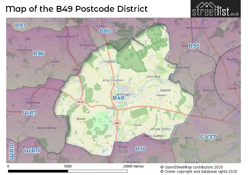
When it comes to local government, postal geography often disregards political borders. However, for a breakdown in the B49 District: the district mostly encompasses the Stratford-on-Avon District (360 postcodes), and finally, the Wychavon District area (22 postcodes).
Weather Forecast for B49
Press Button to Show Forecast for Alcester
| Time Period | Icon | Description | Temperature | Rain Probability | Wind |
|---|---|---|---|---|---|
| 12:00 to 15:00 | Cloudy | 11.0°C (feels like 8.0°C) | 5.00% | N 11 mph | |
| 15:00 to 18:00 | Cloudy | 12.0°C (feels like 10.0°C) | 5.00% | NNE 9 mph | |
| 18:00 to 21:00 | Cloudy | 11.0°C (feels like 9.0°C) | 5.00% | NE 7 mph | |
| 21:00 to 00:00 | Cloudy | 9.0°C (feels like 7.0°C) | 7.00% | NNE 4 mph |
Press Button to Show Forecast for Alcester
| Time Period | Icon | Description | Temperature | Rain Probability | Wind |
|---|---|---|---|---|---|
| 00:00 to 03:00 | Cloudy | 7.0°C (feels like 6.0°C) | 5.00% | N 4 mph | |
| 03:00 to 06:00 | Cloudy | 6.0°C (feels like 5.0°C) | 7.00% | NNW 2 mph | |
| 06:00 to 09:00 | Cloudy | 7.0°C (feels like 5.0°C) | 5.00% | NNW 4 mph | |
| 09:00 to 12:00 | Cloudy | 8.0°C (feels like 6.0°C) | 4.00% | N 9 mph | |
| 12:00 to 15:00 | Partly cloudy (day) | 11.0°C (feels like 9.0°C) | 1.00% | N 9 mph | |
| 15:00 to 18:00 | Cloudy | 12.0°C (feels like 11.0°C) | 3.00% | N 7 mph | |
| 18:00 to 21:00 | Sunny day | 11.0°C (feels like 10.0°C) | 1.00% | NE 4 mph | |
| 21:00 to 00:00 | Clear night | 6.0°C (feels like 5.0°C) | 1.00% | N 4 mph |
Press Button to Show Forecast for Alcester
| Time Period | Icon | Description | Temperature | Rain Probability | Wind |
|---|---|---|---|---|---|
| 00:00 to 03:00 | Partly cloudy (night) | 4.0°C (feels like 3.0°C) | 2.00% | W 4 mph | |
| 03:00 to 06:00 | Cloudy | 3.0°C (feels like 1.0°C) | 4.00% | W 4 mph | |
| 06:00 to 09:00 | Cloudy | 5.0°C (feels like 2.0°C) | 6.00% | W 7 mph | |
| 09:00 to 12:00 | Cloudy | 8.0°C (feels like 6.0°C) | 9.00% | WNW 7 mph | |
| 12:00 to 15:00 | Overcast | 10.0°C (feels like 8.0°C) | 14.00% | NW 7 mph | |
| 15:00 to 18:00 | Cloudy | 11.0°C (feels like 9.0°C) | 10.00% | WNW 7 mph | |
| 18:00 to 21:00 | Cloudy | 10.0°C (feels like 8.0°C) | 7.00% | NNW 7 mph | |
| 21:00 to 00:00 | Cloudy | 7.0°C (feels like 5.0°C) | 5.00% | NNE 4 mph |
Press Button to Show Forecast for Alcester
| Time Period | Icon | Description | Temperature | Rain Probability | Wind |
|---|---|---|---|---|---|
| 00:00 to 03:00 | Cloudy | 6.0°C (feels like 4.0°C) | 7.00% | NE 4 mph | |
| 03:00 to 06:00 | Cloudy | 5.0°C (feels like 2.0°C) | 10.00% | ESE 4 mph | |
| 06:00 to 09:00 | Cloudy | 5.0°C (feels like 3.0°C) | 14.00% | ENE 7 mph | |
| 09:00 to 12:00 | Cloudy | 8.0°C (feels like 5.0°C) | 14.00% | ESE 9 mph | |
| 12:00 to 15:00 | Overcast | 10.0°C (feels like 8.0°C) | 18.00% | ESE 9 mph | |
| 15:00 to 18:00 | Overcast | 11.0°C (feels like 9.0°C) | 19.00% | ESE 9 mph | |
| 18:00 to 21:00 | Cloudy | 10.0°C (feels like 8.0°C) | 19.00% | ESE 7 mph | |
| 21:00 to 00:00 | Cloudy | 7.0°C (feels like 5.0°C) | 20.00% | E 7 mph |
Press Button to Show Forecast for Alcester
| Time Period | Icon | Description | Temperature | Rain Probability | Wind |
|---|---|---|---|---|---|
| 00:00 to 03:00 | Cloudy | 6.0°C (feels like 4.0°C) | 20.00% | ESE 7 mph | |
| 03:00 to 06:00 | Cloudy | 6.0°C (feels like 3.0°C) | 22.00% | ENE 7 mph | |
| 06:00 to 09:00 | Overcast | 6.0°C (feels like 4.0°C) | 20.00% | NNE 7 mph | |
| 09:00 to 12:00 | Overcast | 9.0°C (feels like 7.0°C) | 22.00% | ENE 9 mph | |
| 12:00 to 15:00 | Cloudy | 11.0°C (feels like 9.0°C) | 18.00% | E 9 mph | |
| 15:00 to 18:00 | Light rain | 11.0°C (feels like 10.0°C) | 51.00% | E 9 mph | |
| 18:00 to 21:00 | Heavy rain shower (day) | 11.0°C (feels like 9.0°C) | 57.00% | E 9 mph | |
| 21:00 to 00:00 | Cloudy | 9.0°C (feels like 7.0°C) | 21.00% | ENE 9 mph |
Where is the B49 Postcode District?
The data shows that the B49 postcode district is located in Alcester. Alcester is a town in Warwickshire. It is surrounded by several nearby towns, such as Studley to the North, Henley-in-Arden to the North East, Redditch to the North West, Stratford-upon-Avon to the South East, Evesham to the South, Pershore to the South West, and Droitwich to the West. The distance from Alcester to London is approximately 89.16 miles.
The district is within the post town of ALCESTER.
The sector has postcodes within the nation of England.
The B49 Postcode District is covers the following regions.
- Warwickshire - Herefordshire, Worcestershire and Warwickshire - West Midlands (England)
- Worcestershire - Herefordshire, Worcestershire and Warwickshire - West Midlands (England)
| Postcode Sector | Delivery Office |
|---|---|
| B49 5 | Alcester Delivery Office |
| B49 6 | Alcester Delivery Office |
| B49 9 | Alcester Delivery Office |
| B | 4 | 9 | - | X | X | X |
| B | 4 | 9 | Space | Numeric | Letter | Letter |
Tourist Attractions within the Postcode Area
We found 1 visitor attractions within the B49 postcode area
| Coughton Court |
|---|
| Historic Properties |
| Historic House / House and Garden / Palace |
| View Coughton Court on Google Maps |
Current Monthly Rental Prices
| # Bedrooms | Min Price | Max Price | Avg Price |
|---|---|---|---|
| 1 | £1,880 | £1,880 | £1,880 |
| 2 | £1,095 | £2,305 | £1,700 |
| 3 | £1,450 | £1,450 | £1,450 |
| 4 | £1,800 | £1,800 | £1,800 |
Current House Prices
| # Bedrooms | Min Price | Max Price | Avg Price |
|---|---|---|---|
| 3 | £626,000 | £1,350,000 | £932,286 |
| 4 | £675,000 | £1,150,000 | £873,744 |
| 5 | £650,000 | £2,750,000 | £1,368,056 |
| 8 | £1,900,000 | £1,900,000 | £1,900,000 |
Estate Agents who Operate in the B49 District
| Logo | Name | Brand Name | Address | Contact Number | Total Properties |
|---|---|---|---|---|---|
 | Alcester | Sanders & Sanders | Burton House High Street, Alcester, B49 5AB | 01789 339291 | 29 |
 | Alcester | Jeremy McGinn & Co | 49 High Street, Alcester, B49 5AF | 01789 339445 | 13 |
 | Stratford-Upon-Avon | Peter Clarke & Co | 53 Henley Street, Stratford-Upon-Avon, CV37 6PT | 01789 415444 | 5 |
 | covering Birmingham | Purplebricks | Suite 7 First Floor Cranmore Drive Shirley Solihull B90 4RZ | 024 7542 7306 | 4 |
 | Bramshott Place | Inspired Villages Group Re-Sales | Unit 3, Edwalton Business Park, Landmere Lane, Edwalton, Nottingham, NG12 4JL | 07512 314491 | 4 |
| Type of Property | 2018 Average | 2018 Sales | 2017 Average | 2017 Sales | 2016 Average | 2016 Sales | 2015 Average | 2015 Sales |
|---|---|---|---|---|---|---|---|---|
| Detached | £480,027 | 51 | £484,433 | 56 | £467,636 | 60 | £417,318 | 56 |
| Semi-Detached | £251,233 | 43 | £274,733 | 46 | £256,220 | 47 | £235,743 | 49 |
| Terraced | £210,797 | 46 | £282,038 | 54 | £210,123 | 51 | £191,478 | 60 |
| Flats | £211,650 | 23 | £185,645 | 57 | £124,306 | 31 | £113,462 | 26 |