The B6 6 postcode sector is within the county of West Midlands.
Did you know? According to the 2021 Census, the B6 6 postcode sector is home to a bustling 11,373 residents!
Given that each sector allows for 400 unique postcode combinations. Letters C, I, K, M, O and V are not allowed in the last two letters of a postcode. With 138 postcodes already in use, this leaves 262 units available.
The largest settlements in the B6 6 postal code are BIRMINGHAM and Aston.
The B6 6 Postcode shares a border with B6 5 (Aston, BIRMINGHAM), B6 7 (BIRMINGHAM, Aston, Witton), B19 1 (BIRMINGHAM, Lozells, Handsworth) and B20 3 (BIRMINGHAM, Handsworth).
The sector is within the post town of BIRMINGHAM.
B6 6 is a postcode sector within the B6 postcode district which is within the B Birmingham postcode area.
The Royal Mail delivery office for the B6 6 postal sector is the Aston Delivery Office.
The area of the B6 6 postcode sector is 0.48 square miles which is 1.24 square kilometres or 306.34 square acres.
Waterways within the B6 6 postcode sector include the River Tame.

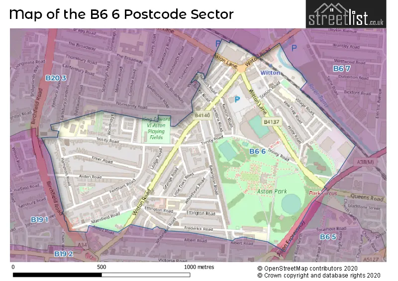
Map of the B6 6 Postcode Sector
Explore the B6 6 postcode sector by using our free interactive map.
| B | 6 | - | 6 | X | X |
| B | 6 | Space | 6 | Letter | Letter |
Official List of Streets
Aston (15 Streets)
BIRMINGHAM (31 Streets)
Unofficial Streets or Alternative Spellings
Weather Forecast for B6 6
Press Button to Show Forecast for Aston Villa F.C.
| Time Period | Icon | Description | Temperature | Rain Probability | Wind |
|---|---|---|---|---|---|
| 06:00 to 09:00 | Overcast | 8.0°C (feels like 6.0°C) | 21.00% | NW 11 mph | |
| 09:00 to 12:00 | Cloudy | 9.0°C (feels like 6.0°C) | 36.00% | NW 16 mph | |
| 12:00 to 15:00 | Cloudy | 11.0°C (feels like 8.0°C) | 7.00% | NNW 16 mph | |
| 15:00 to 18:00 | Overcast | 11.0°C (feels like 8.0°C) | 9.00% | NNW 16 mph | |
| 18:00 to 21:00 | Cloudy | 10.0°C (feels like 7.0°C) | 6.00% | NNW 11 mph | |
| 21:00 to 00:00 | Cloudy | 8.0°C (feels like 6.0°C) | 6.00% | NNE 7 mph |
Press Button to Show Forecast for Aston Villa F.C.
| Time Period | Icon | Description | Temperature | Rain Probability | Wind |
|---|---|---|---|---|---|
| 00:00 to 03:00 | Cloudy | 6.0°C (feels like 5.0°C) | 7.00% | NE 4 mph | |
| 03:00 to 06:00 | Cloudy | 5.0°C (feels like 3.0°C) | 5.00% | NNE 4 mph | |
| 06:00 to 09:00 | Cloudy | 4.0°C (feels like 2.0°C) | 5.00% | N 4 mph | |
| 09:00 to 12:00 | Sunny day | 7.0°C (feels like 4.0°C) | 2.00% | N 7 mph | |
| 12:00 to 15:00 | Overcast | 10.0°C (feels like 8.0°C) | 8.00% | N 7 mph | |
| 15:00 to 18:00 | Overcast | 11.0°C (feels like 9.0°C) | 8.00% | NNE 7 mph | |
| 18:00 to 21:00 | Partly cloudy (day) | 10.0°C (feels like 8.0°C) | 3.00% | NNE 7 mph | |
| 21:00 to 00:00 | Partly cloudy (night) | 7.0°C (feels like 6.0°C) | 2.00% | NNE 4 mph |
Press Button to Show Forecast for Aston Villa F.C.
| Time Period | Icon | Description | Temperature | Rain Probability | Wind |
|---|---|---|---|---|---|
| 00:00 to 03:00 | Clear night | 6.0°C (feels like 4.0°C) | 1.00% | NE 4 mph | |
| 03:00 to 06:00 | Partly cloudy (night) | 5.0°C (feels like 3.0°C) | 1.00% | N 2 mph | |
| 06:00 to 09:00 | Cloudy | 5.0°C (feels like 4.0°C) | 4.00% | N 4 mph | |
| 09:00 to 12:00 | Cloudy | 8.0°C (feels like 7.0°C) | 5.00% | NNE 4 mph | |
| 12:00 to 15:00 | Overcast | 10.0°C (feels like 9.0°C) | 9.00% | NNE 7 mph | |
| 15:00 to 18:00 | Overcast | 11.0°C (feels like 9.0°C) | 11.00% | NNE 7 mph | |
| 18:00 to 21:00 | Cloudy | 10.0°C (feels like 8.0°C) | 5.00% | NE 9 mph | |
| 21:00 to 00:00 | Partly cloudy (night) | 8.0°C (feels like 6.0°C) | 4.00% | NE 9 mph |
Press Button to Show Forecast for Aston Villa F.C.
| Time Period | Icon | Description | Temperature | Rain Probability | Wind |
|---|---|---|---|---|---|
| 00:00 to 03:00 | Cloudy | 6.0°C (feels like 4.0°C) | 6.00% | ENE 7 mph | |
| 03:00 to 06:00 | Clear night | 5.0°C (feels like 3.0°C) | 3.00% | NNE 7 mph | |
| 06:00 to 09:00 | Sunny day | 5.0°C (feels like 3.0°C) | 4.00% | NNE 7 mph | |
| 09:00 to 12:00 | Partly cloudy (day) | 8.0°C (feels like 6.0°C) | 5.00% | NE 9 mph | |
| 12:00 to 15:00 | Overcast | 10.0°C (feels like 8.0°C) | 10.00% | NE 9 mph | |
| 15:00 to 18:00 | Overcast | 11.0°C (feels like 9.0°C) | 10.00% | NE 11 mph | |
| 18:00 to 21:00 | Partly cloudy (day) | 10.0°C (feels like 8.0°C) | 6.00% | NE 9 mph | |
| 21:00 to 00:00 | Cloudy | 8.0°C (feels like 5.0°C) | 8.00% | NE 7 mph |
Schools and Places of Education Within the B6 6 Postcode Sector
Birchfield Primary School
Academy sponsor led
Trinity Road, Birmingham, , B6 6AJ
Head: Mrs Zoe Thewlis
Ofsted Rating: Good
Inspection: 2022-09-14 (583 days ago)
Website: Visit Birchfield Primary School Website
Phone: 01214645661
Number of Pupils: 686
King Edward VI Aston School
Academy converter
Frederick Road, Birmingham, West Midlands, B6 6DJ
Head: Mr Matthew Brady
Ofsted Rating: Outstanding
Inspection: 2022-05-11 (709 days ago)
Website: Visit King Edward VI Aston School Website
Phone: 01213271130
Number of Pupils: 1001
Titan St Georges Academy
Free schools alternative provision
Prestbury Road, Birmingham, , B6 6EE
Head: Mrs Nicola Hutchison
Ofsted Rating: Good
Inspection: 2019-07-09 (1746 days ago)
Website: Visit Titan St Georges Academy Website
Phone: 01212962277
Number of Pupils: 0
Yew Tree Community Junior and Infant School (NC)
Academy converter
Yew Tree Road, Birmingham, West Midlands, B6 6RX
Head: Shaukat Islam
Ofsted Rating: Good
Inspection: 2022-11-09 (527 days ago)
Website: Visit Yew Tree Community Junior and Infant School (NC) Website
Phone: 01214642967
Number of Pupils: 485
House Prices in the B6 6 Postcode Sector
| Type of Property | 2018 Average | 2018 Sales | 2017 Average | 2017 Sales | 2016 Average | 2016 Sales | 2015 Average | 2015 Sales |
|---|---|---|---|---|---|---|---|---|
| Detached | £0 | 0 | £0 | 0 | £0 | 0 | £0 | 0 |
| Semi-Detached | £161,750 | 6 | £103,873 | 3 | £126,906 | 8 | £132,000 | 8 |
| Terraced | £125,073 | 31 | £113,368 | 53 | £106,856 | 43 | £109,361 | 36 |
| Flats | £50,000 | 1 | £67,750 | 2 | £114,000 | 1 | £70,500 | 1 |
Important Postcodes B6 6 in the Postcode Sector
B6 6AH is the postcode for BIRCHFIELD LIBRARY, 3, Trinity Road
B6 6AJ is the postcode for Birchfield Community School, Trinity Road, NEW BLOCK, Birchfield Community School, Trinity Road, Birchfield Community School, 27 Trinity Road, and School Community House, 27 Trinity Road
B6 6DJ is the postcode for SPORTS HALL, King Edwards VI Aston School, Frederick Road, OLD SCHOOL, King Edwards VI Aston School, Frederick Road, King Edwards VI Aston School, Frederick Road, and DOUGLAS HOUSE, King Edwards VI Aston School, Frederick Road
B6 6ED is the postcode for Fire Station, Ettington Road
B6 6EE is the postcode for West Midlands Fire Service, Aston Fire Station, 86 Prestbury Road
B6 6EJ is the postcode for Aston Academy, 99 Whitehead Road
B6 6EL is the postcode for Eden Boys Leadership Academy, Whitehead Road
B6 6JA is the postcode for Aston Health Centre, Trinity Road
B6 6JD is the postcode for STABLES, Aston Hall, Trinity Road, Aston Park Pavilion & Pitches, Aston Park, Trinity Road, and Aston Hall, Trinity Road
B6 6JY is the postcode for Alshafa Medical Centre, 5-7 Little Oaks Road
B6 6LS is the postcode for KING EDWARD VI ASTON SCHOOL PLAYING FIELDS, 79, Trinity Road
B6 6RX is the postcode for Yew Tree Community School NC, Yew Tree Road, and Yew Tree Community School Nc, Yew Tree Road, Perry Barr
| The B6 6 Sector is within these Local Authorities |
|
|---|---|
| The B6 6 Sector is within these Counties |
|
| The B6 6 Sector is within these Water Company Areas |
|
Tourist Attractions within the B6 6 Postcode Area
We found 1 visitor attractions within the B6 postcode area
| Aston Hall |
|---|
| Historic Properties |
| Historic House / House and Garden / Palace |
| View Aston Hall on Google Maps |